Lighthouses of Indonesia: Talaud and Sangihe Islands

The Republic of Indonesia has been independent since 1945 after having been the Dutch East Indies for more than 350 years. It is a huge country, stretching along both sides of the Equator for more than 46 degrees of longitude (roughly 5100 km or 3200 miles). Comprised of some 17,000 islands (more than 6000 inhabited islands), it has hundreds of major aids to navigation.

Sulawesi (Celebes) is a major island in the northern part of the country. Shaped like an artistically drawn letter K, Sulawesi consists mostly of four narrow peninsulas. The Makassar Strait separates Sulawesi from Kalimantan (Borneo) to the west. The Celebes Sea is north of the island, the Molucca Sea is on the northeast, the Banda Sea is to the southeast, and the Flores Sea is on the south. Makassar, also called Ujung Pandang, is the major port. This page includes the lighthouses of the Talaud Islands and Sangihe Islands, archipelagos lying between Sulawesi and the southern Philippine island of Mindanao. The island chains separate the Philippine Sea to the east from the Celebes Sea (known in Indonesia as the Sulawesi Sea) to the west.

Indonesia is divided into 38 provinces and the provinces are subdivided into regencies (kabupaten). The Talaud and Sangihe Islands are administered as three regencies of Sulawesi Utara (North Sulawesi Province). Although the islands are remote, they are well populated, with a total population of about 300,000.

More than 700 languages are spoken in Indonesia. The official national language, Indonesian (Bahasa Indonesia), was standardized from a form of Malay that served as a lingua franca across the archipelago. In Indonesian a lighthouse is a mercusuar or a menara suar. Tanjung is a cape, ujung is a headland or point of land, bukit is a hill, sungai is a river, kuala or muara is an estuary or river mouth, pulau is an island, karang is a reef, batu is a rock, laut is a sea, selat is a strait, teluk is a bay, pelabuhan is a harbor, and labuhan is a port.

Aids to navigation in Indonesia are operated and maintained by the Directorate of Marine Navigation within the Directorate General of Sea Transportation.

ARLHS numbers are from the ARLHS World List of Lights. Admiralty numbers are from volume F of the Admiralty List of Lights & Fog Signals. U.S. NGA List numbers are from Publication 112.

General Sources
Online List of Lights - Indonesia - North Sulawesi Islands
Photos by various photographers posted by Alexander Trabas.
Indonesian Lighthouses
Historic postcard views from the collection of Michel Forand.
World of Lighthouses - Indonesia
Photos by various photographers available from Lightphotos.net.
GPSNavigationCharts
Navigational chart for the islands.
Navionics Charts
Navigation chart for the islands.

Pulau Miangas Light, January 2018
Instagram photo by panjiarifs

Kepulauan Talaud (Talaud Islands) Regency Lighthouses

The Talaud Islands are the northeasternmost islands of North Sulawesi, located in the Philippine Sea northeast of the Sangihe Islands and southeast of Mindanao in the Philippines. The islands are quite remote but they are well populated with a population of nesrly 100,000. Pulau Karakelong is by far the largest of the islands and has most of the population.

Pulau Miangas Lighthouse
 
Pulau Miangas (Isla Palmas) (3?)
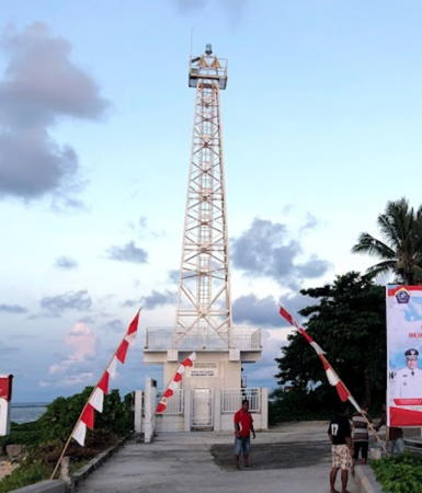
Date unknown (around 2017). Active; focal plane 130 m (427 ft); three white flashes every 20 s. 30 m (98 ft) octagonal skeletal tower with lantern and gallery, covered with buff-colored panels, rising from an octagonal 1-story concrete building. Several coast guard station buildings. A photo is at the top of this page, Nocka Maarisit has a 2022 photo, Esa Daya Lestari has a 2018 photo showing two of the panels missing, and Google has a blurry satellite view. The NKRI letters on the tower are the initials of Negara Kesatuan Republik Indonesia (The Unitary State of the Republic of Indonesia). Charles Buts has a street view taken from the top of the tower. Bing has a satellite view of the previous square skeletal tower. The station buildings are about 300 m (1000 ft) downhill southwest of the tower. Pulau Miangas is a small island isolated in the Philippine Sea about 125 km (75 mi) east of the southern tip of Mindanao. Known as Isla Palmas in the Philippines, the island was claimed by the U.S. as part of the Philippines in the early 1900s, but in 1928 the Permanent Court of Arbitration ruled in favor of the Netherlands. Indonesia maintains sovereignty as successor to the Netherlands. A settlement on the island has a population of about 700. NGA and ARLHS list this light under the Philippines, but the Admiralty has it placed properly in Indonesia. Located at the highest point of the island. Site and tower open. ARLHS PHI-112; Admiralty F2138; NGA 15156.

Nanusa Islands Lighthouses
These are small islands located about 30 km (19 mi) northeast of Pulau Karakelong.

Pulau Marampit
2006. Active; focal plane 45 m (148 ft); two white flashes every 12 s. 40 m (131 ft) square skeletal tower with lantern and gallery, painted white and mounted atop a 2-story coast guard station building. Izzuddin Abdul Aziz has the 2018 photo at right, Rizki Bachtiar has a 2012 photo (3/4 the way down the page), and Google has a satellite view of the station. Located at the northern tip of Pulau Marampit, the largest of the Nanusa group, island about 10 km (6 mi) northeast of Pulau Keratung. Site status unknown. Admiralty F2134.2.
* Pelabuhan Marampit
2020. Active; focal plane 18 m (59 ft); white flash every 3 s. 15 m (49 ft) (?) square skeletal tower. A photo is available but the light may be too new to appear in Google's fuzzy satellite view. The tower appears taller than its listed height. Located on the quay of the ferry terminal of the Marampit village, on the south coast of the island. Admiralty F2134.1.

Pulau Marampit Light, Talaud Islands, July 2018
Google Maps photo by Izzuddin Abdul Aziz
* Pulau Karatung (2?)
Date unknown. Active; focal plane 12 m (39 ft); white flash every 3 s. 10 m (33 ft) round hourglass-shaped white fiberglass tower, mounted on a square concrete base. Don Kalangit has a 2017 photo, the light is at the right edge in Ernest Rifan's 2020 photo, and a very distant 2018 view is available, and Google has a satellite view. This light is similar to many harbor lights in Indonesia's out islands. Pulau Karatung is a small but inhabited island about 50 km (30 mi) northeast of the northern tip of Pulau Talaud. The Admiralty's location places this light near the northwestern point of the island but no lighthouse is seen in satellite views of that area. Accessible only by boat. Site status unknown. Admiralty F2134; NGA 25199.
Pulau Intata
Date unknown (2006 or later). Active; focal plane 55 m (180 ft); two white flashes every 10 s. 30 m (98 ft) square skeletal tower with gallery, painted white. Farel Manus Kasili has a distant 2017 aerial view (tower at upper right), the light is near the left edge in Dandi Ratri Antoro's view, and Google has a satellite view. Located on an uninhabited island about 15 km (9 mi) south of Pulau Marampit. Accessible only by boat. Site status unknown. Admiralty F2133.9.
Pulau Kakarutan (Kakorotan)
Date unknown. Active; focal plane 45 m (148 ft); two white flashes every 10 s. 30 m (98 ft) square skeletal tower with gallery, painted white and mounted on a white 1-story equipment building. No photo available but Google has a satellite view. Located on the east side of a small island only 2.5 km (1.5 mi) south of the Pulau Intata lighthouse. Accessible only by boat. Site status unknown. Admiralty F2133.8.
Pulau Kakarutan North
Date unknown (must be recent). Active; focal plane about 20 m (66 ft); white light, pattern unknown. Approx. 17 m (56 ft) square skeletal tower with gallery, painted white and mounted on a white 1-story equipment building. Embo Yan Chanel's 2021 photo is at right, Herry Dariwu has a 2018 closeup photo, Aulia Iswi has a 2023 photo, and Google has an indistinct satellite view. The Admiralty lists this light as Pulau Malo (Kakolotan), an island southwest of Pulau Kakarutan, and places the light on the north side of that island. Neither Google's satellite view nor Bing's satellite view show any structures on Pulau Malo. Located at a pier on the north side of Pulau Kakarutan. Accessible only by boat. Site status unknown. Admiralty F2133.7.

Pulau Kakarutan North Light, Talaud Islands, June 2021
Google Maps photo by Embo Yan Chanel

Pulau Karakelong Lighthouses
Karakelong is the largest of the Talaud Islands, about 80 km (50 mi) long north to south and roughly 10 km (6 mi) wide. It has a population of about 60,000. Its princcipal town Melonguane is the capital of the Talaud Islands Regency.
Tanjung Ambora (Mamahan) (2)
Around 2020. Active; focal plane 42 m (138 ft); three white flashes every 20 s. 40 m (131 ft) octagonal concrete tower with lantern and gallery. Tower painted white, lantern red. Several coast guard station buildings. A closeup 2022 photo is at right, Jitro Tamawiwy has a view from a distance, and Google has a satellite view of the station. The new lighthouse replaced a skeletal tower seen in Bing's satellite view. Located at the northwestern tip of Pulau Karakelong. Site status unknown. Admiralty F2132; NGA 25202.
* Pelabuhan Gunaloh (Ganaloh, Ganalo)
2016. Active; focal plane 17 m (56 ft); white flash every 3 s. Approx. 14 m (43 ft) square skeletal tower with gallery, painted white Muhammad Zidan has a 2021 distant view and Google has a satellite view. This is a new port; it was not seen at all in an earlier Bing satellite view. Located on the northeastern coast of Pulau Karakelong. Site open, tower closed. Admiralty F2132.4.
* Pelabuhan Melonguane
Date unknown. Active; focal plane 13 m (43 ft); white flash every 3 s. Approx. 12 m (39 ft) square white skeletal tower. A 2021 photo is available, Suhandri Lariwu has a 2018 photo, and Google has an indistinct satellite view. Located on the waterfront of Melonguane, the regency capital at the south end of Pulau Karakelong. Site open, tower closed. Admiralty F2129.8.
* Teluk Beo Beo (2)
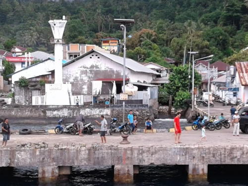
Date unknown. Active; focal plane 19 m (62 ft); continuous red light. NGA lists a 10 m (33 ft) white metal mast but the light appears to be on a much taller skeletal tower, probably on the tower to the left of the ferry terminal in Novry Morong's distant view and on the left in a distant 2022 view. Bing has a satellite view. Located near the waterfront in Beo, on the west coast of Pulau Karakelong. Site open, tower closed. Admiralty F2130, NGA 25204.

Tanjung Ambora Light, Pulau Karakelong, September 2022
Google Maps photo by AC 1
* Pelabuhan Essang
Date unknown. Active; focal plane about 18 m (59 ft); white flash every 3 s. Approx. 15 m (49 ft) square white skeletal tower mounted on a square 1-story equipment shelter. A photo is available and Google has an indistinct satellite view. Located at the base of the pier at Essang, a small port on the northwestern coast of Pulau Karakelong. Site open, tower closed. Admiralty F2132.2.

Pulau Salebabu and Pulau Kaburuang Lighthouses
Tanjung Salonggaka
Date unknown. Active; focal plane 20 m (66 ft); two white flashes every 6 s. Approx. 15 m (49 ft) square white skeletal tower. No photo available but Google has a satellite view. Located at the northern tip of Pulau Salebabu, a smaller island south of Pulau Karakelong and opposite Melonguane. Site status unknown. Admiralty F2132.5; NGA 25198.5.
* Pelabuhan Lirung
Date unknown. Active; focal plane 12 m (39 ft); white flash every 3 s. 10 m (33 ft) round hourglass-shaped white fiberglass tower with one black horizontal band. Ibnu Mamonto has a 2023 photo, 2019 photo is available, the light is at the left edge of Sukur Mana's photo of the waterfront, and Google has an indistinct satellite view. Located at the ferry terminal of Lirung, a town on the east coast of Pulau Salebabu. Site open, tower closed. Admiralty F2133; NGA 25198.
* Pelabuhan Mangaran
Date unknown. Active; focal plane about 20 m (66 ft); white light, 2 s on, 1 s off. Approx. 15 m (49 ft) square white skeletal tower mounted on a 1-story white equipment building. A 2022 photo is available, Rully Setiawan Dewanda has a distant photo, and Google has an indistinct satellite view. Located at the base of a pier near the northern tip of Pulau Kaburuang, an island southeast of Pulau Salebahu. Site open, tower closed. Admiralty F2133.3.
Tanjung Pallo (Palle)
Date unknown. Active; focal plane 65 m (213 ft); white flash every 10 s. 40 m (131 ft) octagonal white skeletal tower with lantern and gallery extending an octagonal concrete tower. Several coast guard station buildings. A 2022 photo is at right, Steven Sumolang has a 2019 photo, and Google has a satellite view of the station. Located about 2 km (1.25 mi) southwest of the village of Damau at the southern tip of Pulau Kaburuang, marking the south end of the Talaud Islands. Site status unknown. ARLHS IDO-318; Admiralty F2133.5; NGA 25197.8.

Tanjung Pallo Light, Pulau Kaburuang, September 2022
Google Maps photo by Rio Saletia

Kepulauan Sangihe (Sangihe Islands) Regency Lighthouses

The Sangihe Islands are a chain of volcanic islands extending almost due north from the northeastern tip of Sulawesi. The islands form the dividing line between the Celebes Sea to the west and the Philippine Sea to the east. In 2007 the Sangihe Islands Regency was divided, placing the southern half of the island chain in the new Sitaro Islands Regency.

Marore (Kawio) Islands Lighthouses
These are small islands at the extreme northern end of the Sangihe chain, west of the Talaud Islands.
Pulau Batubawaikang
Date unknown. Active; focal plane 13 m (43 ft); white flash every 3 s. 13 m (43 ft) square skeletal tower mounted on a square 1-story equipment shelter, all on a square platform supported by concrete piers. Izzuddin Abdul Aziz has the 2018 photo seen at right and the shadow of the tower is conspicuous in Google's satellite view. This light marks the extreme northern end of the island chain, only 69 m (43 mi) south of Balut Island, Philippines. Located on an islet just off the northern tip of Pulau Marore. Accessible only by boat. Admiralty F2135.3.
Pulau Marore (Pulau Maru)
Date unknown. Active; focal plane 180 m (591 ft); two white flashes every 10 s. 40 m (131 ft) square skeletal tower with lantern and gallery. Tower painted white, lantern red. Several station buildings. Christian Romy has a view from the island's harbor and Google has a satellite view of the station. Pulau Marore is the Indonesia's northernmost island in the Celebes Sea, located about 90 km (55 mi) south of Mindanao in the Philippines. Accessible only by boat. Site status unknown. Admiralty F2135; NGA 25200.
Pulau Kawio
2006. Active; focal plane 50 m (164 ft); two white flashes every 10 s. 30 m (98 ft) square skeletal tower with gallery, painted white. Two station buildings. Jean Tumuwe has a distant view from the sea and Google has a satellite view of the station. Located on a small island about 10 km (6 mi) southwest of Pulau Marore. Accessible only by boat. Site status unknown. Admiralty F2134.8; NGA 25200.2.
* Pelabuhan Kawio
2020. Active; focal plane 20 m (66 ft); white flash every 3 s. 15 m (49 ft) square white skeletal tower. Jean Tumuwe has a distant view from the sea and Google has a satellite view. Located at the Kawio ferry terminal near the southern tip of the island. Site open, tower closed. Admiralty F2134.7.
Pulau Kemboling
2006. Active; focal plane 52 m (171 ft); white flash every 6 s. 10 m (33 ft) square white skeletal tower. No photo available but Bing has an indistinct satellite view. Located at the southern tip of an uninhabited island just to the south of Pulau Kawio. Accessible only by boat. Site status unknown. Admiralty F2134.5; NGA 25200.5.
Pulau Matutuang
Date unknown. Active; focal plane 107 m (351 ft); white flash every 5 s. Approx. 35 m (115 ft) tapered square skeletal tower with gallery, painted white. Several station buildings. Fahmi Fachrurozi has an aerial view of the island (this lighthouse on the left), a very distant view from the sea (lighthouse to the left on the island) is available, and Bing has a satellite view of the station. Located on an isolated high island near the northern end of the Sangihe chain, about 40 km (25 mi) southeast of Pulau Kawio. Accessible only by boat. Site status unknown. ARLHS IDO-220; Admiralty F2135.5; NGA 25201.

Pulau Batubawaikang Light, Kawio Islands, July 2018
Google Maps photo by Izzuddin Abdul Aziz
* Pelabuhan Matutuang
Date unknown. Active; focal plane 17 m (56 ft); white flash every 3 s. Approx. 15 m (49 ft) square skeletal tower painted white. A view from the sea is available, the light can be seen in Fahmi Fachrurozi's view, and Bing has an indistinct satellite view. Located at the base of the pier on Pulau Matutuang. Site open, tower closed. Admiralty F2135.7.
Pulau Kawaluso (Kawalusu)
Date unknown. Active; 80 m (262 ft); white flash every 8 s. Approx. 25 m (82 ft) square white skeletal tower. A 2023 view and another view are available, Sesar Dwi has a view from the sea (lighthouse on the left), and Bing has an indistinct satellite view. Located on the southwesternmost of the Marore islands. Accessible only by boat. Site status unknown. Admiralty F2136; NGA 25197.5.
Pulau Dumarehe
Date unknown. Active; focal plane 34 m (112 ft); white flash every 4 s. 10 m (33 ft) square white skeletal tower. No photo available and the tower is not seen in Bing's satellite view. Located on the southernmost of the Marore islands. Accessible only by boat. Site status unknown. Admiralty F2137; NGA 25197.2.

Pulau Sangihe (Sangir Besar) Area Lighthouses
Pulau Sangihe, also known as Sangir Island, is by far the largest island of the chain; it is 40 km (25 mi) long and about 8 km (5 mi) wide. It is the site of the active Mount Awu volcano, which erupted disastrously in 1856 and more recently in 1966.

Pulau Lipang
2020. Active; focal plane 20 m (66 ft); white flash every 3 s. 10 m (33 ft) square skeletal tower painted white. No photo available but Google has an indistinct satellite view. Located at the northwestern tip of Pulau Lipang, a small island about 20 km (13 mi) northwest of Pulau Sangihe. Site status unknown. Admiralty F2127.9.
* Pelabuhan Lipang
2016. Active; focal plane 15 m (49 ft); white flash every 5 s. 10 m (33 ft) square skeletal tower painted white. Ardi Ogelang has posted a photo and Google has an indistinct satellite view. Located at the foot of the pier on Pulau Lipang. Site open, tower closed. Admiralty F2127.8.
Pulau Buang (Salehe)
Date unknown. Active; focal plane 80 m (262 ft); two white flashes every 10 s. Approx. 30 m (98 ft) skeletal tower, painted white. No photo available but Bing has an indistinct satellite view. Located on an uninhabited island about 35 km (22 mi) northeast of the northern point of Pulau Sangihe, the central island of the archipelago. Accessible only by boat. Site status unknown. Admiralty F2128; NGA 25197.
Pulau Manipa
Date unknown. Active; focal plane 69 m (226 ft); white flash every 10 s. 30 m (98 ft) white concrete tower with lantern and gallery. David Vilabella contrubuted a 2010 view from the sea and Google has a satellite view. Located near the southwestern tip of an island off the north end of Pulau Sangihe. Site status unknown. ARLHS IDO-218; Admiralty F2127.5; NGA 25196.5.
* [Peta]
Date unknown. Active; focal plane 9 m (30 ft); continuous red light. 6 m (20 ft) white mast. Valen Fatubun has a drone view (mast at left end of port area) and Google has a street view and a satellite view. Located on the waterfront of Peta, a town on the northeast coast of Pulau Sangihe. Site open, tower closed. Admiralty F2126; NGA 25196.
Pulau Benglaut (Pulau Beng)
Date unknown. Active; focal plane 106 m (348 ft); white flash every 5 s. 10 m (33 ft) round white fiberglass tower. No photo available but Google has a satellite view. Located at the east end of Pulau Benglaut, a small high island off the southeast coast of Pulau Sangihe. Accessible only by boat. Site status unknown. Admiralty F2127; NGA 25194.
Tanjung Toademanandu
Date unknown. Active; focal plane 20 m (66 ft); white flash every 3 s. Approx. 15 m (49 ft) square skeletal tower mounted on a square 1-story equipment shelter. Entire lighthouse is white. Rama Dalvin has a 2018 photo (also seen at right), Eka Putra has a closeup, and Google has a satellite view. Located on a prominent cape at the southwestern end of Pulau Singihe. Site status unknown. Admiralty F2120.5; NGA 25188.
Tanjung Bunakeng (Tahuna, Pulau Sangihe)
Date unknown. Active; focal plane 130 m (427 ft); white flash every 3 s. 30 m (98 ft) square skeletal tower, painted white. No photo available but Google has a satellite view of the station. Located on heights at the southern entrance to the harbor of Tahuna, the principal town on the west coast of Pulau Sangihe. Site status unknown. DSI-5341; Admiralty F2123; NGA 25190.

Tanjung Toademanandu Light, Pulau Singihe, June 2018
Google Maps photo by Rama Dalvin
* Teluk Tahuna (Pulau Sangihe)
Date unknown. Active; focal plane 30 m (105 ft); white flash every 3 s. 30 m (98 ft) skeletal tower, painted white. Romandito Mahendrayudha has a photo, Charles Buts has a street view, but somehow the tower escapes notice in Google's indistinct satellite view. Located near the waterfront in Tahuna. Site open, tower closed. Admiralty F2123.5.
* Pelabuhan Tua Tahuna
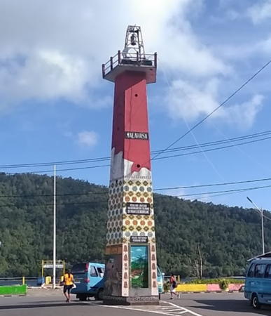
Date unknown. Active; focal plane 32 m (105 ft); two white flashes every 8 s. Approx. 20 m (66 ft) square tower; upper half painted red and lower half elaborately decorated. Suhardi Liwut's 2019 photo is at right, Don Kalangit has a photo of the light in action, Dina Suherman Suherman has a closeup, and Google has an indistinct satellite view. The light is provided by two powerful spotlights. The light is on the waterfront of a port on the north side of Tahuna Bay. Site open, tower closed. Admiralty F2124(?); NGA 25192(?).
Pulau Kahakitang
Date unknown. Active; focal plane 16 m (52 ft); green flash every 3 s. 16 m (52 ft) tower on a platform supported by piles. No photo available but Google has a satellite view. Located on the west side of the entrance to the harbor of Pulau Kahakitang, a U-shaped island about 25 km (15 mi) south of Pulau Sangihe. Accessible only by boat. Site open, tower closed. Admiralty F2120.48.
* Pelabuhan Pulau Kahakitang
Date unknown. Active; focal plane 15 m (49 ft); white flash every 3 s. Approx. 12 m (39 ft) square skeletal tower painted white and mounted on a square 1-story equipment shelter. Novianto Imburi Novi has a 2022 photo and Google has a satellite view. Located at the base of the pier on Pulau Kahakitang. Site open, tower closed. Admiralty F2120.45.
* Pulau Para
Date unknown. Active; focal plane 16 m (52 ft); white flash every 3 s. Approx. 13 m (43 ft) square skeletal tower painted white and mounted on a square 1-story equipment shelter. Don Kalangit has a 2019 photo and Google has a satellite view. Located at the base of the pier on Pulau Para, an island about 35 km (22 mi) south of Pulau Sangihe. Site open, tower closed. Admiralty F2120.4.

Pelabuhan Tua Tahuna Light, Tahuna, April 2019
Google Maps photo by Suhardi Liwut

Kepulauan Sitaro (Sitaro Islands) Regency Lighthouses

Separated from the Sangihe Islands Regency in 2007, the Sitaro Islands Regency includes a chain of small volcanic islands between Pulau Sangihe and the northeastern tip of Sulawesi. Siau is the largest and most populated island. The name Sitaro is an acronym for the three major islands of the group, Siau, Tagulandang and Biaro.

Pulau Makalehi Lighthouses
Pulau Makalehi
Date unknown. Active; focal plane 150 m (492 ft); two white flashes every 10 s. 40 m (131 ft) square skeletal tower with lantern and gallery, painted white and mounted on a large station building. Ronny Buol's photo is at right and Google has a satellite view. Makalehi is a tall, currently inactive volcanic cone about 25 km (15 mi) west of Pulau Siau, one of the larger islands of the Sangihe chain. Located on the southern slope of the volcano. Accessible only by boat. Site status unknown. Admiralty F2120.3.
* Pelabuhan Makalehi
Date unknown. Active; focal plane 15 m (49 ft); white light, 2 s on, 1 s off. Approx. 11 m (36 ft) square white skeletal tower with gallery. Don Kalangit has a view from the sea, another distant view from the sea is available, and Bing has an indistinct satellite view. Located a short distance north of the pier on Makalehi. Site open, tower closed. Admiralty F2120.25.

Pulau Siau Lighthouses
 
* Pehe
Date unknown. Active; focal plane about 16 m (52 ft); white light, 2 s on, 1 s off. Approx. 12 m (39 ft) square white skeletal tower mounted on a square 1-story equipment shelter. A 2018 photo is available, Marwan Mohamad has a photo, Charles Buts has a distant street view from across the harbor and Google has a satellite view. The street view also shows the relentlessly active volcano Karangetang. Located at the north end of the waterfront at Pehe, a village on the west coast of Pulau Siau. Site open, tower closed. Admiralty F2120.2.
Pehe Entrance South
Date unknown. Active; focal plane 16 m (52 ft); green flash every 3 s. 16 m (52 ft) square skeletal tower mounted on a square 1-story equipment shelter, all on a platform supported by piles. The light is seen at the left in a street view by Charles Buts, George Meikalz has a very distant view, and Google has an indistinct satellite view. This light and the next one warn ships away from reefs on both sides of the entrance to Pehe. Located about 500 m (0.3 mi) west of the Pehe waterfront. Accessible only by boat. Site open, tower closed. Admiralty F2120.23.
Pehe Entrance North
Date unknown. Active; focal plane 17 m (56 ft); red flash every 3 s. 17 m (56 ft) square skeletal tower mounted on a square 1-story equipment shelter, all on a platform supported by piles. A view from the Pehe pier is available, the light is seen at the right in a street view by Charles Buts and Google has an indistinct satellite view. Located about 500 m (0.3 mi) northwest of the Pehe waterfront. Accessible only by boat. Site open, tower closed. Admiralty F2120.22.
Pulau Makalehi Light
Pulau Makalehi Light, Sitaro Islands, November 2008
photo copyright Ronny Buol; used by permission
* Ulu
Date unknown. Active; focal plane 15 m (49 ft); white flash every 3 s. 13 m (43 ft) round barbell-shaped white fiberglass tower, mounted on a square concrete base. A portion of Alfred Manambangtua's photo is at right, Wuntat Widi has a 2018 street view, Charles Buts has an evening street view from the pier, and Google has an indistinct satellite view. This light is similar to many harbor lights in Indonesia's out islands. Located on the waterfront of Ulu, a settlement on the east coast of Pulau Siau. Site open, tower closed. Admiralty F2120; NGA 25184.
Karang Pihise (Pihise Reef)
Early 2010s. Active; focal plane 12 m (39 ft); white flash every 3 s. 12 m (39 ft) square white skeletal tower mounted on a platform supported by piles. Aryando Kangiras has a distant view and Google has a distant satellite view. This light guides ships in the narrow strait between Pulau Siau and Pulau Pahepa. Located on the southeastern tip of Pulau Siau. Accessible only by boat. Site open, tower closed. Admiralty F2118.

Pulau Manuba Area Lighthouses
* Pulau Gunatin (Pelabuhan Buhias)
2019. Active; focal plane 20 m (66 ft); white flash every 3 s. 15 m (49 ft) square white skeletal tower. Marwan Mohamad has a distant view from the sea and Google has an indisinct satellite view. Located at the ferry terminal on the southeast side of Pulau Gunatin, an island just north of Pulau Manuba off the southeastern end of Pulau Siau. Site open, tower closed. Admiralty F2119.5.
Pulau Mahoro (Mahora)
Date unknown. Active; focal plane 80 m (262 ft); two white flashes every 8 s. Approx. 20 m (66 ft) square skeletal tower with gallery, painted white. No photo available but Google has a satellite view. Located on the eastern tip of Pulau Mahoro, a small island off the east end of Pulau Manuba. Accessible only by boat. Site status unknown. Admiralty F2119; NGA 25186.

Pelabuhan Ulu Light, Sitaro Islands, May 2017
Google Maps photo by Alfred Manambangtua

Pulau Tahulandang Area Lighthouses
* Pulau Tahulandang (2?)
Date unknown (since 2010). Active; focal plane 14 m (46 ft); white flash every 3 s. 12 m (39 ft) square skeletal tower painted white. A portion of L.S. Sirapanji's view from the harbor is at right, Rovie Karisihe has a second view, a distant view (halfway down the page) is available, and Google has a satellite view. NGA lists a 12 m (39 ft) post. The Admiralty lists the light as Buhias, but that is also the name of the town on Pulau Gunatin (see above). Located at the base of the pier on Pulau Tahulandang, an island about 35 km (22 mi) south of Pulau Siau and near the south end of the Sangihe chain, about 90 km (55 mi) north northeast of Tanjung Arus. Site open, tower closed. Admiralty F2116; NGA 25180.
Pulau Pasige
Date unknown. Active; focal plane 15 m (49 ft); white flash every 2.5 s. 15 m (49 ft) square red skeletal tower mounted on a square platform supported by piles. No photo available but Google has a satellite view. Located on a reef off the southwest side of a small island west of Pulau Tahulandang. Accessible only by boat. Site status unknown. Admiralty F2114; NGA 25176.

Pulau Biaro Lighthouse
* Pulau Biaro (Pelabuhan Sawang Ino)
Date unknown. Active; focal plane 20 m (66 ft); white light, 2 s on, 1 s off. Approx. 16 m (52 ft) square skeletal tower mounted on a 1-story white concrete equipment shelter. Don Kalangit has a view from the sea, King Ehud has a distant view (lighthouse is in the center) and a second distant view (lighthouse near left edge), and Google has a satellite view. Pulau Biaro is the southernmost of the inhabited islands in the Sangihe chain. Located at the Sawang Ino port on the northwest side of the island. Site open, tower closed. Admiralty F2115.

Pulau Tahulandang Light, Sitaro Islands, October 2017
ex-Google Plus photo by L.S. Sirapanji

Information available on lost lighthouses:

Notable faux lighthouses:

Adjoining pages: North: Southern Mindanao | South: Northern Sulawesi

Return to the Lighthouse Directory index | Ratings key

Posted December 18, 2008. Checked and revised June 30, 2024. Lighthouses: 49. Site copyright 2024 Russ Rowlett and the University of North Carolina at Chapel Hill.