Lighthouses of Indonesia: Northern Sulawesi (Celebes)

The Republic of Indonesia has been independent since 1945 after having been the Dutch East Indies for more than 350 years. It is a huge country, stretching along both sides of the Equator for more than 46 degrees of longitude (roughly 5100 km or 3200 miles). Comprised of some 17,000 islands (more than 6000 inhabited islands), it has hundreds of major aids to navigation.

Sulawesi (Celebes) is a major island in the northern part of the country. Shaped like an artistically drawn letter K, Sulawesi consists mostly of four narrow peninsulas. The Makassar Strait separates Sulawesi from Kalimantan (Borneo) to the west. The Celebes Sea is north of the island, the Molucca Sea is on the northeast, the Banda Sea is to the southeast, and the Flores Sea is on the south. Makassar, also called Ujung Pandang, is the major port.

Indonesia is divided into 38 provinces (provinsi) and the provinces are subdivided into county units called regencies (kabupaten). This page covers the northern Minahasa Peninsula of the island, including the provinces of Gorontalo and North Sulawesi. North Sulawesi Province also includes the Talaud and Sangihe Islands to the north of Sulawesi; lighthouses of these islands are described on a separate page.

More than 700 languages are spoken in Indonesia. The official national language, Indonesian (Bahasa Indonesia), was standardized from a form of Malay that served as a lingua franca across the archipelago. In Indonesian a lighthouse is a mercusuar or a menara suar. Tanjung is a cape, ujung is a headland or point of land, bukit is a hill, sungai is a river, kuala or muara is an estuary or river mouth, pulau is an island, karang is a reef, batu is a rock, laut is a sea, selat is a strait, teluk is a bay, pelabuhan is a harbor, and labuhan is a port.

Aids to navigation in Indonesia are operated and maintained by the Directorate of Marine Navigation within the Directorate General of Sea Transportation.

ARLHS numbers are from the ARLHS World List of Lights. Admiralty numbers are from volume F of the Admiralty List of Lights & Fog Signals. U.S. NGA List numbers are from Publication 112.

General Sources
Online List of Lights - Indonesia - Sulawesi
Photos by various photographers posted by Alexander Trabas.
Indonesian Lighthouses
Historic postcard views from the collection of Michel Forand.
World of Lighthouses - Indonesia
Photos by various photographers available from Lightphotos.net.
Sulawesi Map
A useful map from orangesmile.com.
Navionics Charts
Navigation chart for Sulawesi.

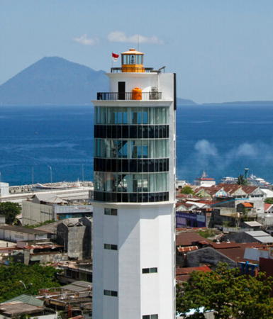
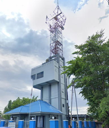
Manado Light, Manado, November 2012
Flickr photo copyright Walter Mosca; used by permission

Gorontalo Province North Coast Lighthouses

Gorontalo Utara (North Gorontalo) Regency Lighthouses
Karang Buliogut
Date unknown. Active; focal plane 12 m (39 ft); white flash every 3 s. 12 m (39 ft) white skeletal tower on a square platform supported by piles. No photo available but Bing has a distant satellite view. Located on the northeastern side of a reef about 10 km (6 mi) offshore of Sumalata. Accessible only by boat. Site open, tower closed. Admiralty F2058; NGA 25126.
Karang Laimula
Date unknown. Active; focal plane about 13 m (43 ft); white flight, pattern unknown. Approx. 13 m (43 ft) white tower on a square platform supported by piles. No photo available but Google has a satellite view that probably shows the lighthouse. Located on the north side of a reef about 40 km (25 mi) northwest of Anggrek. Accessible only by boat. Site open, tower closed. Admiralty F2059.
Karang Otangala North
Date unknown. Active; focal plane 9 m (30 ft); green flash every 3 s. 9 m (30 ft) round green barbell-shaped fiberglass tower on a triangular platform supported by piles. No photo available but Google has a satellite view. Located off the northeastern tip of Pulau Otangala, an island that shelters the port of Anggrek. Accessible only by boat. Site open, tower closed. Admiralty F2061.3.
Karang Otangala South
Date unknown. Active; focal plane 8 m (26 ft); green flash every 5 s. 8 m (26 ft) green barbell-shaped fiberglass (?) tower on a platform supported by piles. No photo available but Google has a satellite view. Located off the southeastern tip of Pulau Otangala, an island that shelters the port of Anggrek. Accessible only by boat. Site open, tower closed. Admiralty F2061.7.
Anggrek (1)
Date unknown. Inactive at least since 2022. 12 m (39 ft) white barbell-shaped fiberglass tower. Adri Warokka has a 2016 photo, Hafidz Asshidiq has a 2018 photo, Buyung Dharma has a 2016 aerial photo, and Google has a satellite view. Located on the waterfront of Anggrek, a new port in western Gorontolo. Site and tower closed.
Anggrek (2)
2017. Active; focal plane about 30 m (98 ft); white flash every 2 s. Approx. 26 m (85 ft) white skeletal tower with gallery. . Ilham Whit's 2023 photo is at right and Google has a satellite view. Located at the south end of the quay at Anggrek. Site and tower closed. Admiralty F2061.9.

Anggrek Light, North Gorontalo, May 2023
Google Maps photo by Ilham Whit
Karang Pontianak
Date unknown. Active; focal plane 8 m (26 ft); red flash every 4 s. 8 m (26 ft) round red barbell-shaped fiberglass tower on a triangular platform supported by piles. No photo available but Google has a satellite view. Located on a reef about 2 km (1.25 mi) east of Anggrek. Accessible only by boat. Site open, tower closed. Admiralty F2061.5.
Karang Otilade (2)
Around 2016. Active; focal plane 12 m (39 ft); white flash every 12 s. 12 m (39 ft) square white skeletal tower rising from a square 1-story equipment shelter mounted on a platform supported by piles. Ijun Buheli has a 2020 photo and also a second photo showing the remains of the original light. Google has a satellite view. Located on a reef about 15 km (9 mi) north of Kwandang. Accessible only by boat. Site open, tower closed. Admiralty F2061.1; NGA 25129.
* Kwandang (Sungai Kwandang, Teluk Kwandang) (2?)
Date unknown. Active; focal plane about 14 m (46 ft); white flash every 3 s. Approx. 12 m (39 ft) white barbell-shaped metal or fiberglass tower. Google has a street view and a satellite view. NGA lists a "metal post." Kwandang, a town of about 35,000 residents, is the capital of North Gorontalo Regency. Located on the waterfront of Kwandang. Site open, tower closed. Admiralty F2062; NGA 25132.
Pulau Hulawa (Lito Lampu)
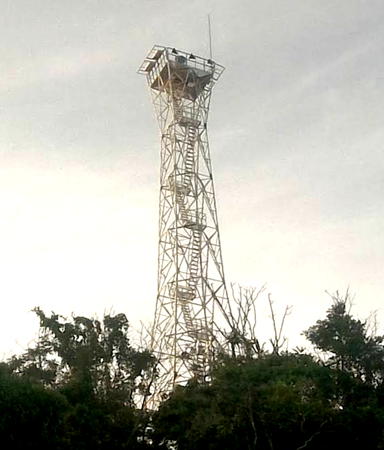
Date unknown. Active; focal plane 40 m (131 ft); white flash every 3 s. 25 m (82 ft) square skeletal tower with gallery, painted white. A distant view (also seen at right) is available and Google has a fuzzy satellite view. Located on an island off the north coast of Sulawesi, about 25 km (15 mi) north of Malingkapoto. Accessible only by boat. Site status unknown. Admiralty F2060; NGA 25128.

Pulau Hulawa Light, North Gorontalo, September 2018
Google Maps photo by yayan

North Sulawesi Province: Minahasa Peninsula North Coast Lighthouses

North Sulawesi (Sulawesi Utara) Province includes the final third of the sinuous Minahasa Peninsula plus the Sangihe (Sangir) Islands, a chain that stretches north almost to Mindanao in the Philippines. The islands separate the Celebes Sea on the west from the Molucca Sea on the east.

Bolaang Mongondow Utara (North Bolaang Mongondow) Regency Lighthouses
Pulau Bongkil (Bangkil, Bangkit)
Date unknown. Active; focal plane 17 m (56 ft); white flash every 5 s. 10 m (33 ft) round white fiberglass tower mounted on a platform supported by piles. Waktu News has a 2019 drone view and Google has a satellite view. Located on a small island about 16 km (10 mi) off the coast at the border between Gorontalo and North Sulawesi provinces. Accessible only by boat. Site open, tower closed. Admiralty F2062.5; NGA 25134.
* Tanjung Sidupa
Date unknown. Active; focal plane 16 m (52 ft); white flash every 3 s. Approx. 13 m (43 ft) square white skeletal tower mounted on a 1-story white equipment building. Asy-syura Ailani Setyawan has a view from the harbor (a portion is seen at right), Andika Jaelani has a 2021 photo, and Google has a street view and an indistinct satellite view. Located on the waterfront of Tanjung Sidupa. Site open, tower closed. Admiralty F2062.8.

Bolaang Mongondow Regency Lighthouses
Pulau Tikus
Date unknown. Active; focal plane 15 m (49 ft); white flash every 3 s. 15 m (49 ft) round white fiberglass tower mounted on a square platform supported by piles. Samy Khaydirah has a distant view and Google has a satellite view. Located on a reef in an estuary entrance off the ferry port of Labuan Uki. Accessible only by boat. Site open, tower closed. Admiralty F2063.3; NGA 25137.
Inobonto
Date unknown. Active; focal plane about 13 m (43 ft); continuous red light. Approx. 13 m (43 ft) white skeletal (?) tower mounted on a square platform supported by piles. No photo available but Bing has a fuzzy satellite view. Located at the end of a reef about 500 m (1/3 mi) off the waterfront of Inobonto, a town of about 15,000 residents. Accessible only by boat. Site open, tower closed. Admiralty F2063.5.

Tanjung Sidupa Light, Tanjung Sidupa, June 2017
ex-Google Plus photo by Asy-syura Ailani Setyawan
* Tanjung Lobu
Date unknown. Active; focal plane 24 m (79 ft); white flash every 5 s. 10 m (33 ft) round white barbell-shaped fiberglass tower mounted on a square concrete base. A five-second video shows a closeup of the lighthouse, a photo of the base is available, and Google has a satellite view. Site open, tower closed. Admiralty F2063.8; NGA 25139.

Minahasa Selatan (South Minahasa) Regency Lighthouses
Megah Jaya Prima Lestari No. 3
Around 2018. Active; focal plane about 25 m (82 ft); green (?) light, pattern unknown. Approx. 25 m (82 ft) square skeletal tower mounted on a platform supported by piles. Google has a street view and a satellite view. Located off the south side of the Limbah B3 LPG Terminal in Tenga, about 25 km (15 mi) west of Amurang. Accessible only by boat. Site and tower closed. Admirlty F2063.803.
Megah Jaya Prima Lestari No. 1
Around 2018n. Active; focal plane about 15 m (49 ft); red light, pattern unknown. Approx. 15 m (49 ft) square red skeletal tower mounted on a platform supported by piles. Ian Pontoh has a distant view and Google has a street view and a satellite view. Located off the north side of the Limbah B3 LPG Terminal in Tenga. Accessible only by boat. Site and tower closed. Admirlty F2063.801.
Tanjung Sangket
Date unknown. Active; focal plane 16 m (52 ft); two white flashes every 2.5 s. Approx. 15 m (49 ft) square white skeletal tower mounted on a platform supported by piles. No photo available but Bing has a satellite view. Located off the low cape about 5 km (3 mi) northwest of Amurang. Accessible only by boat. Site open, tower closed. Admiralty F2063.84.
* Amurang
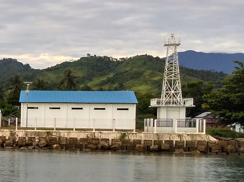
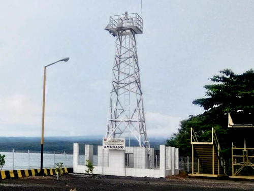
Date unknown. Active; focal plane 15 m (49 ft); white flash every 3 s. Approx. 12 m (39 ft) square white skeletal tower mounted on a 1-story white equipment building. A 2017 photo is at right, Eric Pajow has a closeup photo, and Google has a satellite view. Amurang is the capital of South Minahasa Regency. Located on the waterfront of the Amurang ferry terminal. Site open, tower closed. Admiralty F2063.85.

Amurang Light, Amurang, March 2017
Google Maps photo by It vandri
Tetapaan
Date unknown. Active; focal plane 12 m (39 ft); red flash every 3 s. 12 m (39 ft) red fiberglass tower on a square platform supported by piles. No photo available but Gooogle has a satellite view. Located at the western edge of Pulau Tetapaan, where it marks the northern entrance to Amurang Bay about 15 km (9 mi) northwest of the town. Accessible only by boat. Site open, tower closed. Admiralty F2064.4; NGA 25142.
 

Manado City Lighthouses
Manado is the capital of North Sulawesi and the second largest city of Sulawesi, after Makassar, with a population of about 450,000.

***
Manado (2?)
Date unknown. Active; focal plane 32 m (105 ft); white light, 2 s on, 6 s off. Lantern mounted atop a tall hotel tower. Walter Mosca's photo is at the top of this page, Moch Hanggoro has a closeup photo and a good view, and Google has a street view and a satellite view. NGA descibes this light as a 12 m (39 ft) skeletal tower. Located on Kampus Unsrat Street in downtown Manado. Site open, and visitors can take in the view from the gallery just below the light tower. Admiralty F2066; NGA 25144.
Manado South Mole
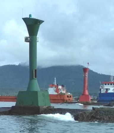
Date unknown. Active; focal plane 12 m (39 ft); green flash every 3 s. 10 m (33 ft) round barbell-shaped green fiberglass tower. A 2017 photo is at right, Juliany Talontong has a 2020 photo, and Google has a street view, and Bing has an indistinct satellite view. Located on the south mole at the entrance to the ferry and small boat harbor of Manado. Site and tower closed, but the light is easy to see from the harbor bridge. Admiralty F2068; NGA 25148.
Manado North Mole
Date unknown. Active; focal plane 12 m (39 ft); red flash every 3 s. 10 m (33 ft) round barbell-shaped red fiberglass tower. A 2017 photo is at right, Moch Hanggoro has a photo, and Google has a street view and Bing has an indistinct satellite view. Located on the north mole at the entrance to the ferry and small boat harbor of Manado. Site and tower closed, but the light is easy to see from the harbor bridge. Admiralty F2070; NGA 25152.
Tanjung Pisok
Date unknown. Active; focal plane 10 m (33 ft); red flash every 3 s. 10 m (33 ft) sqaure red skeletal tower mounted on a square platform supported by piles. No photo available but Google has a satellite view. Located off a cape about 8 km (5 mi) north of the Manado waterfront. Accessible only by boat. Site open, tower closed. Admiralty F2070.4.

Manado Light, Manado, November 2012
Flickr photo copyright Walter Mosca; used by permission

Minahasa Utara (North Minahasa) Regency Lighthouses
Pulau Manterawu
2006. Active; focal plane 50 m (164 ft); two white flashes every 10 s. 40 m (131 ft) "white tower," presumably skeletal and probably mounted on a platform supported by piles. No photo available and the tower has not been found in Google's satellite view of the listed location. Located off an island about 30 km (19 mi) west of Tanjung Arus and 40 km (25 mi) north of Manado. Accessible only by boat. Site status unknown. Admiralty F2070.5; NGA 25156.2.
Tanjung Tarabitan (Torowitan)
Date unknown. Active; focal plane about 18 m (59 ft); nine quick white flashes every 15 s. Approx. 18 m (59 ft) tower on a square platform supported by piles. Lighthouse painted yellow with a black horizontal band. No photo available but Google has a satellite view. Located off the northwestern side of Tanjung Tarabitan, the northernmost point of Sulawesi. Accessible only by boat. Site open, tower closed. Admiralty F2070.8.
* Likopang (Munte) (2)
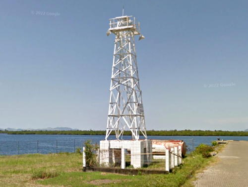
Date unknown. Active; focal plane 10 m (33 ft); white flash every 3 s. Approx. 9 m (30 ft) square white skeletal tower. A 2016 Google street view is seen at right, Andri Suprapto has a 2019 photo, and Google has a satellite view. Likopang is a town southeast of Tanjung Tarabitan. In recent years its port facilities and ferry terminal have been relocated about 5 km (3 mi) west to the village of Munte. The Admiralty has not noted this change. Located on the commercial quay at Munte. Site open, tower closed. Admiralty F2071; NGA 25156.5.
Tanjung Arus (Pulau Talisei, Talise) (2)
Date unknown (station established 1910). Active; focal plane 108 m (354 ft); white flash every 5 s. 20 m (66 ft) square white iron skeletal tower. Tribertus Payung has a closeup 2022 photo and Google has a satellite view of the station. This is not the original lighthouse, an octagonal pyramidal skeletal tower with lantern and gallery. Tanjung Arus is the extreme northeastern tip of Sulawesi, at the end of the Minahasa Peninsula. The lighthouse is not on the mainland cape but on the northern tip of Pulau Talisei (Talise), an island off the cape, about 50 km (30 mi) northeast of Manado. Accessible only by boat. Site status unknown. ARLHS IDO-290; Admiralty F2072; NGA 25156.

Likopang Light, North Minahasa, August 2016
Google Maps street view
Tanjung Batugosoh
Date unknown. Active; focal plane unknown; white flash every 5 s. No description available but Bing has a fuzzy satellite view that probably shows the lighthouse.. Located on or close to a sharp cape on the east side of Pulau Bangka about 13 km (8 mi) southeast of Tanjung Arus. Site status unknown. Admiralty F2075.

North Sulawesi Province: Minahasa Peninsula East Coast Lighthouses

Bitung City: Pulau Lembeh Lighthouses
Bitung is a city of about 235,000 residents at the eastern tip of the Minahasa Peninsula. Pulau Lembeh, an island 25 km (15 mi) long but only 2 km (1.25 mi) wide over most of its length, is parallel to the coast opposite Bitung. The Lembeh Strait separates the island from the Bitung waterfront.
Pulau Lembeh North (Batu Kapal)
Date unknown. Active; focal plane 35 m (115 ft); white light, 3 s on, 3 s off. Listed as a "white beacon," this may be an approx. 10 m (33 ft) post with gallery. No photo available but Google has an indistinct satellite view. Located atop a steep bluff a the northwestern end of Pulau Lembeh. Site status unknown. Admiralty F2079.57; NGA 25157.
Batukapal (Pulau Batu Kapal)
Date unknown. Active; focal plane 35 m (115 ft); white flash every 4 s. Approx. 9 m (30 ft) round barbell-shaped white concrete tower. Rian Indra Manggala has a view from the sea and Google has a satellite view. This light is atop a steep rocky islet off the northeastern tip of Pulau Lembeh, about 20 km (13 mi) northeast of Kota Bitung. Accessible only by boat. Site status unknown. Admiralty F2079.56.
Pulau Susulina
Date unknown. Active; focal plane 25 m (82 ft); white light, 3 s on, 3 s off. Described only as a "white beacon" by NGA; Google's satellite view shows a post with gallery. Located on a tiny island just off the southeast side of Pulau Lembeh. Site status unknown. Admiralty F2079.55; NGA 25162.
Karang Napokering (Pulau Lembah Southwest)
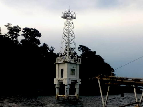
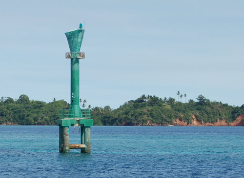
Date unknown. Active; focal plane 17 m (56 ft); two green flashes every 10 s. 17 m (56 ft) round hourglass-shaped tower standing on a square platform supported by four piles. Entire lighthouse is green. Semuel Muhaling's photo is at right and Bing has a satellite view. Located on the west (outside) edge of a reef off the southwestern tip of Pulau Lembah, marking the south entrance to the Lembah Strait. Accessible only by boat. Site open, tower closed. Admiralty F2079.5; NGA 25164.
Tanjung Labuan Kompeni (Compenie)
Date unknown. Active; focal plane 58 m (190 ft); three white flashes every 15 s. 10 m (33 ft) round white fiberglass tower. No photo available but Google has a satellite view. Located on a promontory of Pulau Lembeh opposite the Bitung waterfront. Site status unknown. Admiralty F2079; NGA 25172.
Pulau Lembah Southwest Light
Karang Napokering Light, Bitung, December 2008
ex-Panoramio photo copyright Semuel Muhaling; permission requested

Bitung City: Lembeh Strait Lighthouses
Tanjung Batuangus
Date unknown. Active (?); listed with focal plane 15 m (49 ft); green flash every 3 s. Approx. 9 m (30 ft) tower mounted on a square platform on a rock. Grace Kelly Hosea has a 2024 photo, another 2024 photo is available, N. I. Sudibyo has an aerial view, and Google has an indistinct satellite view. This does not appear to be a working light. Located on the west side of the northern entrance to the narrow Lembeh Strait. Accessible only by boat. Site open, tower closed. Admiralty F2077; NGA 25158.
Pulau Satu (Pulau Sarena)
Date unknown. Active; focal plane 18 m (59 ft); red flash every 3 s. 15 m (49 ft) red barbell-shaped tower mounted on a platform supported by piles. A street view is available and Bing has an indistinct satellite view. Located on Pulau Satu, a tiny island off the north side of Pulau Sarena northeast of Bitung. Accessible only by boat. Site open, tower closed. Admiralty F2078; NGA 25160.
* Bitung
Date unknown. Active; focal plane 23 m (75 ft); white flash every 2 s. Approx. 22 m (72 ft) square cylindrical skeletal tower mounted atop the a square VTS (harbor control) tower. Google's 2022 street view is at right, Mayada Limbong has a 2016 closeup photo, and Google has a satellite view. Located at the south end of the main wharf at Bitung. Site open, tower closed. Admiralty F2078.8.
Cahaya Lestrai Port (No. 3)
2021. Active; focal plane 18 m (59 ft); white flash every 10 s. Approx. 14 m (46 ft) square cylindrical white skeletal tower. No photo available but Google has a satellite view. Located in a new power plant at Kerna, on the southwest side of Bitung. Site and tower closed. Admiralty F2079.49.

Minahasa Regency Lighthouses
Lilang (Tanjung Kapas)
Date unknown. Active; focal plane 70 m (230 ft); white flash every 3 s. 30 m (98 ft) skeletal tower with gallery, painted white. Setyawan Diponegoro has a 2023 view from the sea and Google has a street view and a satellite view. Located on a steep headland at Lilang, on the east coast of the Minahasa Peninsula about 30 km (19 mi) southeast of Manado. Site status unknown. ARLHS IDO-159; Admiralty F2079.6; NGA 25168.
 

Bitung Light, Bitung, October 2022
Google Maps street view
 
Pulau Pakolor
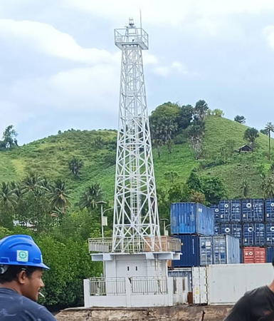
Date unknown. Active; focal plane 126 m (413 ft); white flash every 4.5 s. Approx. 40 m (131 ft) tapered square skeletal tower with lantern and gallery, painted white. Iswandi Runturambi has a photo (also seen at right) and Bing has a good satellite view of the station. This unusually high light has a listed range of 50 km (30 mi). Located on a small island off the east coast of the peninsula about 55 km (35 mi) southwest of the Lembah Strait entrance. Accessible only by boat. Site status unknown. ARLHS IDO-176; Admiralty F2079.7; NGA 25169.

Minahasa Tenggara (Southeast Minahasa) Regency Lightbeacon
* [Belang]
Date unknown. Active; focal plane about 15 m (49 ft); light, pattern unknown. Approx. 12 m (39 ft) mast. Google has a street view and the mast is in front of the large blue-roofed building in Google's satellite view. Located at the base of the pier in Belang. Site status unknown. Admiralty F2080.

Bolaang Mongondow Timur (East Bolaang Mongondow) Regency Lighthouses
* Kotabunan
Date unknown. Active; focal plane about 15 m (49 ft); white light, pattern unknown. Approx. 12 m (39 ft) square white skeletal tower with gallery. Faezal Thaib has a photo and Google has a satellite view and a closeup 2022 street view. Located at the public dock in Kotabunan. Site open, tower closed. Admiralty F2081.
Pulau Pondang (Pulau Pardana)
Date unknown (station established 1912). Active; focal plane 73 m (240 ft); white flash every 4 s. 22 m (72 ft) skeletal tower, painted white. No photo available but Google has a satellite view. Located on a small island just offshore on the northern entrance to the Gulf of Tomini from the Molucca Sea. Accessible only by boat. Site status unknown. ARLHS IDO-233; Admiralty F2082; NGA 25228.

Bolaang Mongondow Regency Lighthouse
* Taboyangan (Torosik)
Date unknown. Active; focal plane 16 m (52 ft); white flash every 3 s. 10 m (33 ft) square white skeletal tower. Dwi Ayu Ningtias Ali has a 2022 closeup photo and Google has a 2022 street view and an indistinct satellite view. Located at a small harbor on the north coast of the Gulf of Tomini about 40 km (25 mi) south of Kotamobagu. Site open, tower closed. Admiralty F2082.5.

Pulau Pakolor Light, Minihasa Regency, August 2016
Google Maps photo by Iswandi Runturambi

Gorontalo Province South Coast (Gulf of Tomini) Lighthouses

The Gulf of Tomini is a broad bay between the Minahasa (Northern) and Central Peninsulas of Sulawesi.

Gorontalo City Lighthouses
The provincial capital of Gorontalo is a city of about 205,000 residents.
* Pelabuhan Gorontalo
Date unknown. Active; focal plane about 18 m (59 ft); light characteristic unknown. Approx. 15 m (49 ft) square white skeletal tower. Nurulhaqi Asri has a view from the sea and Google has a closeup street view and an indistinct satellite view. Located at the Gorontalo ferry terminal. Site open, tower closed. Not listed by the Admiralty.
Gorontalo (1)
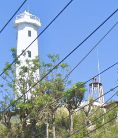
Date unknown. Inactive since 2016. 6 m (20 ft) square white skeletal tower. This light is seen beside of the new lighthouse in Google's street view at right. The listed focal plane of this light was 36 m (118 ft). Site status unknown.
Gorontalo (2)
2016. Active; focal plane about 55 m (180 ft); white flash every 5 s. Approx. 25 m (82 ft) octagonal concrete tower with lantern and gallery. Google's 2023 street view is at right, Ardin Yeyen has a 2016 view from the sea, Abdul Aziz also has a view from the sea, and Google also has a satellite view. The Admiralty and the NGA continue to describe the 6 m (20 ft) skeletal tower. Located on a promontory on the east side of the approach to Gorontalo. Site status unknown. Admiralty F2083; NGA 25232.
* Teluk Gorontalo ("Harbormaster's Office") (2?)
Date unknown. Active; focal plane 20 m (66 ft); white flash every 3 s. Approx. 16 m (52 ft) round barbell-shaped white tower mounted on a square platform supported by piles. Google has a closeup 2023 street view, Irfan Ali has a view from the sea, Marwan Saleh has a view showing this light on the left and the Gorontalo lighthouse on the right, and Google has a satellite view. Apparently the light was formerly on one of the neighboring buildings; it's not clear if one of them is currently the harbormaster's office. Located at the quay on the east side of the narrow entrance to Gorontalo harbor. Site open, tower closed. Admiralty F2083.3; NGA 25234.

Boalemo Regency Lighthouses
Pulau Mohupombodaa
Date unknown. Active; focal plane 17 m (56 ft); white flash every 2 s. 17 m (56 ft) square skeletal tower, probably painted white, mounted on a square platform supported by piles. No photo available but Google has a satellite view. Located on a reef about 3 km (1.8 mi) south of the entrance to the harbor of Tilamuta, the capital of the regency. Accessible only by boat. Site open, tower closed. Admiralty F2083.7.

Gorontalo Light, Gorontalo, December 2023
Google Maps street view
Tilamuta Reef
Date unknown. Active; focal plane 12 m (39 ft); green flash every 4 s. 12 m (39 ft) square green skeletal tower mounted on a square platform supported by piles. Qyara Pramudhita has a distant sea view and Google has a satellite view. Located on a reef on the east side of the entrance to the harbor of Tilamuta. Accessible only by boat. Site open, tower closed. Admiralty F2083.8.
Pulau Tapatada
Date unknown. Active; focal plane 17 m (56 ft); white flash every 5 s. 17 m (56 ft) square skeletal tower, probably painted white, mounted on a square platform supported by piles. Erisa Nur Imama has a distant view, Sherina Aurelya Putri also has a distant view, Qyara Pramudhita has a very distant sea view, and Google has a satellite view. Located on a reef on the west side of the entrance to the harbor of Tilamuta. Accessible only by boat. Site open, tower closed. Admiralty F2083.9.

Pohuwato Regency Lighthouses
Pulau Paniki
Date unknown. Active; focal plane about 13 m (43 ft); continuous red light. Approx. 13 m (43 ft) red tower on a platform supported by piles. No photo available but Bing has a satellite view. Located south of Pulau Piniki, a small island on the approach to the village of Lemito. Accessible only by boat. Site open, tower closed. Admiralty F2084.5.
Popayato
Date unknown. Active; focal plane about 20 m (66 ft); continuous red light. Approx. 15 m (49 ft) square white skeletal tower. No closeup photo available but the light is barely visible at the right edge of Azril Rezzano' very distant view and Google has a satellite view. Located at Popayato, a tiny settlement near the western border of Gorontalo Province. Site open, tower closed. Admiralty F2085.

Information available on lost lighthouses:

Notable faux lighthouses:

Adjoining pages: North: Talaud and Sangihe Islands | East: North Maluku | South: Northeastern Sulawesi | Southwest: Western Sulawesi

Return to the Lighthouse Directory index | Ratings key

Posted December 18, 2008. Checked and revised June 22, 2024. Lighthouses: 52. Site copyright 2024 Russ Rowlett and the University of North Carolina at Chapel Hill.