Lighthouses of the Philippines: Southern Mindanao

The Republic of the Philippines (Pilipinas in Filipino) includes more than 7600 islands stretching over 1750 km (1100 mi) of the western Pacific and separating the Philippine Sea on the east from the South China Sea on the west. The largest islands are Luzon at the northern end of the country and Mindanao at the southern end. As of 2020 the population of the country was about 109 million.

The archipelago was a Spanish colony until the Spanish-American War of 1898, which brought the islands under U.S. administration. Japan occupied the islands during World War II (1942-45) and the country became independent shortly thereafter (1946).

Mindanao, the second largest island of the Philippines, occupies the southern end of the archipelago. The island is very irregular in shape; the largest portion is very roughly elliptical extending northeast to southwest and there is also a long curved extension, the Zamboanga Peninsula, on the west. The small islands of the Sulu Archipelago stretch from the end of the Zamboanga Peninsula towards Borneo. This page lists lighthouses of the Davao Region on the southeast side of the island and the Soccsksargen Region on the south side of the island. Also included are lighthouses of the portion of the autonomous Bangsamoro Region on the southwest mainland of Mindanao.

Filipino and English are official languages in the Philippines. In Filipino a lighthouses is called a parola; an island is an isla or pulo. Many English maritime terms have been adopted into Filipino, including cape, bay, and port, and the names of historic lighthouses are often retained in their Spanish forms.

Lighthouses in the Philippines are maintained by the Marine Safety Services Command of the Philippine Coast Guard.

Many Philippine lighthouses are not well known so better information and photos are always needed.

ARLHS numbers are from the ARLHS World List of Lights. PCG numbers are the Philippines Light List numbers, where known. Admiralty numbers are from volume F of the Admiralty List of Lights & Fog Signals. U.S. NGA List numbers are from Publication 112.

General Sources
Lighthouses in the Philippines
Wikipedia article, with links to articles on several of the individual lighthouses.
Spanish Lighthouses of the Philippines
This is the Directory's own list of the Spanish light stations, with notes on their current status.
Lighthouses in the Philippines
Photos by various photographers available from Wikimedia.
World of Lighthouses - Philippines
Photos by various photographers available from Lightphotos.net.
Online List of Lights - Philippines
Photos by various photographers posted by Alexander Trabas.
Navionics Charts
Navigation chart for southern Mindanao.
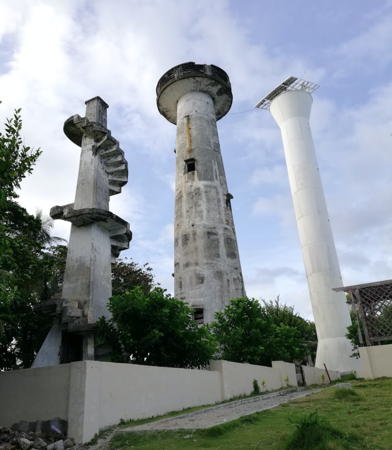

Three lighthouses of Cape San Agustin, Davao Oriental, March 2018
Google Maps photo by Ferdenand Nueve
Davao Region Lighthouses

Davao Oriental Province: East Coast (Philippine Sea) Lighthouses
Baculin Point
Date unknown. Active; focal plane unknown; two white flashes every 10 s. Approx. 15 m (49 ft) white concrete or fiberglass tower. No photo available but Google has a satellite view. Located on a remote promontory on the north side of the entrance to Baculin Bay. Site status unknown. PCG-0410; Admiralty F2239.5.
* Pusan Point (1)
Date unknown. Inactive. Approx. 9 m (30 ft) concrete post with buttresses. Rencel Ina has a photo and this tower is to the left of the active tower in Google's satellite view. Site open, tower closed.
* Pusan Point (2)
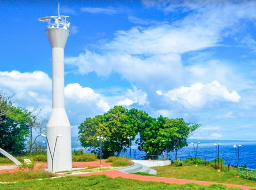
Date unknown. Active; focal plane unknown; white flash every 5 s. Approx. 15 m (49 ft) white concrete tower with gallery. Dodong Usyot has the 2018 photo seen at right, Remo Aguilar has another 2018 photo, Wilfredo Matao Jr. has a 2022 closeup, and Google has a satellite view of the station. Pusan Point is the easternmost point of the Philippines. Located on a prominent cape at the south entrance to Caraga Bay, about 16 km (10 mi) southeast of Caraga. Accessible by road (local guidance recommended). Site open, tower closed. . PCG-0647; Admiralty F2239.3; NGA 15147.5.
Lawigan (Lamigan) Point (1)
Date unknown. Inactive. Approx. 9 m (30 ft) concrete post with a stairway winding around the post. Jouseff Arnold has a 2023 photo of the old and new lighthouses and Google has a satellite view of the station. Located near the active light. Site status unknown, probably open.
Lawigan (Lamigan) Point (2)
Date unknown. Active; focal plane 10 m (33 ft); white flash every 5 s. 10 m (33 ft) round white barbell-shaped tower. Jouseff Arnold has a 2023 photo of the old and new lighthouses and Google has a satellite view of the station. The light is listed as Lamigan Point but the local spelling appears to be Lawigan. Located on a cape at the northern entrance to Pujada Bay, about 25 km (15 mi) southeast of Mati City. A narrow unpaved road leads to the lighthouse. Site status unknown, probably open, tower closed. PCG-0472; Admiralty F2239; NGA 15151.

Pusan Point
Light, Caraga, May 2018
Google Maps photo by Dodong Usyot
* Mati
Date unknown. Active; focal plane 11 m (36 ft); red flash every 5 s. 10 m (33 ft) concrete post; a stairway spirals around the post. The light is to the right of center in a drone view of the port and Google has the street view seen at right and a satellite view. Located at the base of the main pier in Mati, the provincial capital, a seaport with about 150,000 residents at the head of Pujada Bay with a population of about 150,000. Site open, tower closed. Admiralty F2238; NGA 15148.
Pujada Island
Date unknown. Active; focal plane unknown; red flash every 5 s. Approx. 11 m (36 ft) barbell-shaped white fiberglass tower. No photo available but Google has an indistinct satellite view. Located in the southeastern point of Pujada Island, an island in the mouth of Pujada Bay. Accessible only by boat. Site open, tower closed. PCG-0412; Admiralty F2237; NGA 15150.
** Cape San Agustin (Parola Lavigan) (1)
Date unknown (1920s?). Inactive. Approx. 12 m (39 ft) concrete post; a stairway spirals around the post. The tower appears in Ferdenand Nueve's photo at the top of this page. Gino Labiste has a 2017 photo that showed the tower to be in relatively poor condition but Charisma Sato's 2021 photo shows that the old tower has since been restored. Cape San Agustin, the southeasternmost tip of Mindanao, is at the end of a long and narrow peninsula. In 2016 the Tibanban-Lavigan Road, extending the length of the peninsula, was paved in concrete, making the cape accessible by road for casual tourists. There is a visitor center with a small entrance fee. Site open and nothing prevents climbing the tower.
*** Cape San Agustin (Parola Lavigan) (2)
Date unknown (1950s?). Inactive. 24.5 m (80 ft) round unpainted concrete tower with gallery. The tower appears in Ferdenand Nueve's photo at the top of this page, Archie Hilado has a photo, a 2017 photo is available, Ralph Albano has a 2023 photo, Sam Ryan Kim has a closeup, and Google has a 2016 street view and a satellite view. This tower was restored in 2018-19 and is now open for climbing. Site and tower open.
Mati Light, Mati, April 2016
Google Maps street view
* Cape San Agustin (Parola Lavigan) (3)
Date unknown. Active; focal plane 34 m (112 ft); white flash every 5 s. 30.5 m (100 ft) (?) white round concrete tower, flared at the top and bottom. Ferdenand Nueve's 2018 photo of the three lighthouses is at the top of this page, Wikimedia has another photo of the three lights, Archie Hilado has a photo, a 2018 photo is available, Rudnielle Hulapong has a 2020 closeup, and Google has a 2016 street view and a satellite view. This is easily the tallest lighthouse of Mindanao. Located adjacent to the historic lighthouses. Site open, tower closed. . ARLHS PHI-017; PCG-0576; Admiralty F2236; NGA 15152.

Davao Oriental Province: Davao Gulf Lighthouses
The Davao Gulf is a large bay in southeastern Mindanao, roughly 100 km (60 mi) north to south and 50 km (30 mi) wide.

Sigaboy Island
Date unknown. Active; focal plane at least 80 m (262 ft); white flash every 5 s. Approx. 15 m (49 ft) round barbell-shaped white tower. Lyndon Mas has a distant view from the sea and Google has a satellite view. Sigaboy is a small, privately owned island just off Tibanban, a village on the east side of Davao Gulf about 50 km (30 mi) north northwest of Cap San Agustin. Accessible only by boat. Site status unknown. Admiralty F2235.7; NGA 15167.3.
Bitaogan
Date unknown. Active; focal plane unknown; white flash every 10 s. Approx. 10 m (33 ft) barbell-shaped white fiberglass tower. No photo available but the tower is possibly seen in Bing's distant satellite view. Located on a low point of land near San Isidro on the east side of Davao Gulf. May be accessible only by boat. Site status unknown. Admiralty F2235.5; NGA 15167.
Mapanga
Date unknown. Active; focal plane unknown; two white flashes every 10 s. No description given. No photo available and the tower is not seen in Google's satellite view. Located on a very steep promontory about 3 km (2 mi) south of Pintatagan. Site status unknown. PCG-0399; Admiralty F2235.3; NGA 15161.

Davao del Norte Province Lighthouses
Paet Point
Date unknown. Active; focal plane unknown; white flash every 5 s. Approx. 15 m (49 ft) round barbell-shaped white tower. No photo available but Google has a satellite view. Located on the south point of Samal Island, a large island southeast of Davao. Accessible only by boat. Site status unknown. PCG-0746; Admiralty F2233; NGA 15160.1.
Talikud Island
Date unknown. Active; focal plane approx. 11 m (36 ft); white flash every 3 s. 10 m (33 ft) concrete post; a stairway spirals around the post. Gerard Linsangan has a photo, another photo is available, and Google has a satellite view. Located on the southwest coast of Talikud Island, about 25 km (15 mi) southeast of Davao. Site status unknown. ARLHS PHI-061; PCG-0398; Admiralty F2232; NGA 15160.

Davao City Lighthouses
Davao is the metropolis of the southern Philippines. Located on the northwestern shore of the Davao Gulf with a harbor sheltered by Samal Island, it has a population of about 1.75 million and a metropolitan area population of about 2.75 million.

Panacan
Date unknown. Active; focal plane about 12 m (39 ft); green flash every 5 s. Listed as a "concrete structure," this is apparently a concrete post. Around the 0:17 mark in a YouTube video the light is seen distantly in front of the left end of a blue-roofed building. It is barely visible in Google's indistinct satellite view (which does not show the current blue-roofed building). Located at the Philippines Naval Base at Panacan on the north side of Davao. Site and tower closed. PCG-0397; Admiralty F2235; NGA 15163.
Lanang Point (Sasa)
Date unknown. Active; focal plane approx. 20 m (66 ft); red flash every 5 s. Approx. 15 m (49 ft) concrete post; a stairway spirals around the post. Mike Baylon has a photo and Lightphotos.net has Baylon's view from the sea, but it's hard to see the light in Google's satellite view. Located at the industrial Sasa port, on the north end of the Davao waterfront. Site open, tower closed. PCG-0396; Admiralty F2234.5; NGA 15166.
* Davao
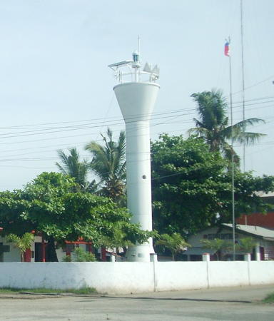
Date unknown (station established 1885). Active; focal plane 11 m (36 ft); green flash every 5 s. 10 m (33 ft) round white tower with a flared top. Mike Baylon's photo is at right, he also has a 2010 photo, Lightphotos.net has his closeup photo, and Google has a street view and a satellite view. Located beside the Philippines Coast Guard station on the Santa Ana Pier in downtown Davao. Site open, tower closed. PCG-0395; Admiralty F2234; NGA 15164.

Davao Light, Davao, June 2009
Flickr photo copyright Mike Baylon; used by permission

Davao del Sur Province Lighthouses
Pasig Point
Date unknown. Active; focal plane about 14 m (46 ft); white flash every 5 s. Approx. 12 m (39 ft) round barbell-shaped white fiberglass tower. A 2021 closeup photo is available and Google has a satellite view. Located on a low point of land about 15 km (9 mi) north of Digos City. Site appears open, tower closed. PCG-0782; Admiralty F2231.7; NGA 15165.
Malalag River
Date unknown. Inactive since 2020. Described by NGA only as a concrete structure. No photo available but Google has an indistinct satellite view. PCG reported this light deactivated in a 31 December 2020 notice to mariners. Malalag Bay is an outstanding natural harbor on the west side of the Davao Gulf. The town of Malalag is on the south shore of the bay; it has a population of about 40,000. Located on a bluff on the west side of the river mouth on the south shore of the bay. Site status unknown. ex-PCG-0393; ex-Admiralty F2231.3; NGA 15178.
Port Malalag (Eagles Point) (2)
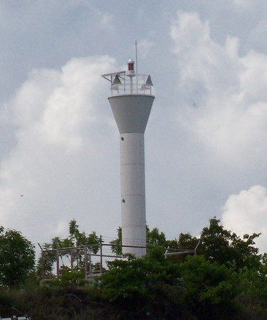
Date unknown (station established 1908). Active; focal plane 31 m (102 ft); red flash every 5 s. Approx. 15 m (49 ft) white round hourglass-shaped tower. Mike Baylon's photo is at right, an evening view and a view from the water are available, and Google has a satellite view. The original light was on a post on the beach. Located on a headland on the south shore of the bay. Site status unknown. PCG-0392; Admiralty F2231.2; NGA 15176.
Malalag Bay (Hill 450)
Date unknown. Inactive since 2020. Described by NGA only as a concrete structure. No photo available but Bing has a fuzzy satellite view. PCG reported this light deactivated in a 31 December 2020 notice to mariners. This was a landfall light with a focal plane of 135 m (443 ft). Located on heights at the eastern entrance to Malabag Bay. Site status unknown. ex-PCG-0391; ex-Admiralty F2231; NGA 15172.
Colapsin Point (1)
Date unknown. Inactive. Approx. 9 m (30 ft) concrete post with a stairway winding around the post. A 2023 closeup photo is available, and Google has a satellite view. Located beside the active lighthouse. Site status unknown.
Colapsin Point (2)
Date unknown. Active; focal plane 74 m (243 ft); white flash every 5 s. Approx. 14 m (46 ft) round white barbell-shaped tower. A 2023 closeup photo is available, Kent Thegreet has a distant view, a drone view of the two lighthouses is available, and Google has a satellite view. Located on a sharp promontory on the south side of the entrance to Malalag Bay. Site status unknown. PCG-0390; Admiralty F2230; NGA 15168.

Davao Occidental Province: Davao Gulf Lighthouses
Tubalan Head
Date unknown. Active; focal plane unknown; white flash every 10 s. Approx. 15 m (49 ft) round barbell-shaped white fiberglass tower. No photo available but Google has a satellite view that probably shows the lighthouse. Located at the tip of a headland about 25 km (15 mi) southeast of Malalag. Site status unknown. Admiralty F2229; NGA 15181.
Tingulo Point
Date unknown. Active; focal plane about 16 m (52 ft); white flash every 10 s. Approx. 15 m (49 ft) round barbell-shaped white fiberglass tower. No photo available but Google has a fuzzy satellite view. Located on a rounded cape about 1.5 km (1 mi) southeast of Tingulo village. Site status unknown. PCG-0784; Admiralty F2228.9; NGA 15181.3.
Port Malalag Light
Port Malalag Light, Malalag, November 2010
Flickr photo copyright Mike Baylon; used by permission
Caliyan (Calian) Point (Talagutong, Caliya)
Date unknown. Active; focal plane unknown; three white flashes every 15 s. Approx. 15 m (49 ft) round barbell-shaped white fiberglass tower. No photo available but Bing has a satellite view. NGA lists this light as "Davao del Sur." Located on a headland south of the village of Talagutong. PCG-0388; Admiralty F2228.7; NGA 15181.5.

Davao Occidental Province: Philippine Sea Lighthouses
Baños Point
Date unknown. Active; focal plane unknown; white flash every 10 s. Approx. 15 m (49 ft) round white barbell-shaped fiberglass tower. Michalle Talingting has a 2022 photo and Google has a satellite view. This light is about 8 km (5 mi) north of its listed location. Located on a prominent cape near José Abed Santos. Site status unknown. PCG-0771; Admiralty F2228.6; NGA 15181.7.
Olanivan (Olaniban) Island
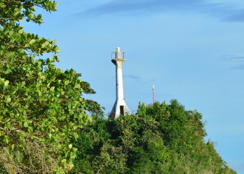
Date unknown. Active; focal plane about 12 m (39 ft); white flash every 8 s. Approx. 9 m (30 ft) round barbell-shaped white fiberglass tower. John Anthony Teker has the photo at right and Bing has a satellite view. Olaniban is a small island off the north end of Sarangani Island, about 25 km (15 mi) east of Tinaca Point, the southernmost point of Mindanao. Accessible only by boat. Site open, tower closed. PCG-0387; Admiralty F2228.5; NGA 15185.5.
Manamil Island (Balut Island)
Date unknown. Active; focal plane about 12 m (39 ft); two white flashes every 10 s. Approx. 9 m (30 ft) round barbell-shaped white fiberglass tower. No photo available but Google has a satellite view. Located on a small island off the southwestern tip of Balut Island, the larger of the two Sarangani Islands. Accessible only by boat. Site open, tower closed. Admiralty F2228.3; NGA 15185.

Olanivan Island Light, Sarangani, March 2016
Google Maps photo by John Anthony Teker

Soccsksargen Region Lighthouses

The formidable name of the Soccsksargen Region (pronounced "sock-sarjen") is an acronym formed from the names of the region's provinces and cities: South Cotabato, Cotabato, Sultan Kudarat, Sarangani and General Santos. Until 2001 the region was called Central Mindanao.

Eastern Sarangani Province Lighthouses
Sarangani Province is divided into two sections separated by Sarangani Bay.

Tinaca Point
Date unknown (station established 1916). Active; focal plane 43 m (141 ft); white flash every 5 s. 11 m (36 ft) white concrete tower with a buttressed base. 1-story octagonal coastwatch station. Dodong Usyot's photo is at right, Barnie Glanios has a 2018 closeup, a distant view from the sea is available, Avel Manansala has a closeup street view, and Google has a satellite view. This light marks the southernmost point of Mindanao. which is also the point of division between the Philippine Sea and Celebes Sea. Site open, tower closed. PCG-0385; Admiralty F2228; NGA 15184.
* [Glan (Canalasan Cove) (2?)]
Date unknown. Active; focal plane 11 m (36 ft); white flash every 5 s. 8 m (26 ft) post. PCG and NGA describe the post as concrete, but it appears likely to be steel in a 2022 photo (post is seen just to the left of the port office). The light is not shown in Bing's indistinct satellite view. Located on the pier at Glan, a small port in the southeast corner of Sarangani Bay. Site open, tower closed. PCG-0526; Admiralty F2227.2; NGA 15182.

General Santos City Lighthouse
Makar Wharf
Date unknown. Active (privately maintained); focal plane unlisted; green flash every 5 s. Approx. 20 m (66 ft) square skeletal tower. No photo available but Google has a satellite view. General Santos City, known informally as GenSan, is an important city and seaport of southern Mindanao; it has a population of at least 700,000. The city is at the northwestern corner of Sarangani Bay. Located on one of the city's main wharves. Site and tower closed. PCG-0384; Admiralty F2227; NGA 15181.8.

Tinaca Point Light, Davao del Sur, January 2017
ex-Google Plus photo by Dodong Usyot

Western Sarangani Province (Celebes Sea) Lighthouses
#Tampuan Point (1)
Date unknown. Replaced. Approx. 15 m (49 ft) square cylindrical skeletal tower, painted with red and white horizontal bands. The light stands behind trees in Paul Partridge's 2011 photo and Google has a satellite view. The light is on the property of a popular diving resort. In 2019 it was moved to a "metal structure," probably a post, to make way for a new building seen in Bing's satellite view. The new light (privately maintained) has focal plane unlisted; red flash every 5 s. Located on a sharp promontory at the western entrance to Sarangani Bay. Site status unknown. Owner/site manager: Lemlunay Resort. Active light: PCG-0534; Admiralty F2226.9.
Kiambing
2020. Active (privately maintained); focal plane 10 m (33 ft); green flash every 5 s. 6 m (20 ft) white fiberglass tower. No photo available and the light is not shown in Google's satellite view. PCG lists the focal plane as 100 m and the Admiralty has copied this figure, but it must be a typo as the surrounding land is quite flat. Located at the Kiambing settlement. Site status unknown. PCG-0658; Admiralty F2226.8; NGA 15161.5.
Buca Point
Date unknown. Active; focal plane unlisted; two white flashes every 5 s. Approx. 10 m (33 ft) round barbell-shaped white fiberglass tower. No photo available but Google has an indistinct satellite view. Located on the beach about 10 km (6 mi) southeast of Kiamba. Site status unknown. PCG-0383; Admiralty F2226.7; NGA 15162.

Sultan Kudarat Province Lighthouse
Lebak Point (?)
Date unknown. Inactive since 2013 and probably removed. 9.5 m (31 ft) white steel and fiberglass tower. No photo available and the light is not seen in Bing's satellite view. Located on a sharp promontory sheltering the harbor of Lepak, on the eastern shore of Moro Gulf. Site status unknown. ex-Admiralty F2226.5; ex-NGA 15186.

Bangsamoro Autonomous Region Lighthouses

The Bangsamoro Autonomous Region was formed in 2019 as a result of a peace settlement between the central government of the Philippines and the Moro Islamic Liberation Front. The region includes the provinces of Maguindanao and Lanao del Sur on the mainland of Mindanao and the three provinces (Basilan, Sulu, and Tawi-Tawi) of the Sulu Archipelago except for the city of Isabela in Basilan Province. Lighthouses of the Sulu Archipelago are described on the Zamboanga and Sulu page.

Maguindanao Province Lighthouses
Maguindanao borders the eastern side of the Moro Gulf a broad embayment of the Celebes Sea between southern Mindanao and the Zamboanga Peninsula.
Tapian Point
Date unknown. Active; focal plane unknown; white flash every 7 s. 10 m (33 ft) white concrete tower. No photo available and the tower has not been found in Google's satellite view. Located on a headland on the Moro Gulf about 20 km (13 mi) southwest of Cotabato. Site status unknown. Admiralty F2226.2; NGA 15187.
Bongo Island
Date unknown. Active (privately maintained); focal plane unknown; white flash every 10 s. Approx. 12 m (39 ft) square white tower. No photo available but Google has a satellite view that may show the tower. Located near the pier on the east coast of Bongo, an island in the northeastern part of Illana Bay about 20 km (13 mi) northwest of Cotabato. Accessible only by boat. Site status unknown. Admiralty F2226.1; NGA 15189.
Cotabato Entrance
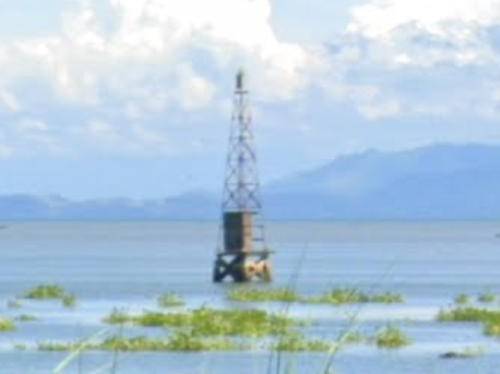
Date unknown. Active; focal plane 10.5 m (34 ft); green flash every 5 s. 10.5 m (34 ft) square skeletal tower on a square platform supported by piles. Google has the street view from shore seen at right, and Bing has an indistinct satellite view. The provincial capital of Cotabato is a city of about 300,000 residents. Located off the entrance to the river leading to Cotabato. Accessible only by boat. Site open, tower closed. PCG-0381; Admiralty F2226; NGA 15188.
Polloc Harbor
Date unknown. Active; focal plane about 12 m (39 ft); red flash every 5 s. Approx. 12 m (39 ft) round red steel and fiberglass tower, flared at the top and bottom, on a platform supported by piles. No photo available and the light has not been located in Google's satellite view. Located just off Polloc Harbor, at the northeastern corner of Moro Gulf. Site status unknown. PCG-0380; Admiralty F2225.5; NGA 15190.

Cotabato Entrance Light, Cotabator, September 2022
Google Maps street view

Northern Mindanao Region Lighthouses

Lanao del Norte Province Lighthouses
Lanao del Norte spans the narrowest section of Mindanao, with a north coast on Iligan Bay and a south coast on the Moro Gulf. Lighthouses of the northern coast are described on the Northern Mindanao page.

* [Sultan Naga Dimaporo]
Date unknown. Active; focal plane about 13 m (43 ft); green flash every 5 s. Approx. 8 m (26 ft) mast. Google has a street view and an indistinct satellite view. Located at the base of the pier in Sultan Naga Dimaporo. Site status unknown. Admiralty F2225.3; NGA 15191.5.

Information available on lost lighthouses:

Notable faux lighthouses:

Adjoining pages: North: Northern Mindanao | Northeast: Caraga | South: Talaud and Sangihe Islands | West: Zamboanga and Sulu

Return to the Lighthouse Directory index | Ratings key

Posted July 24, 2005. Checked and revised February 4, 2024. Lighthouses: 40. Site copyright 2024 Russ Rowlett and the University of North Carolina at Chapel Hill.