Lighthouses of Pakistan

The Islamic Republic of Pakistan was created in 1947, separated from India by the division of the former British Raj. Originally the country was in two widely separated sections west and east of India. The eastern section, called East Bengal and then East Pakistan, broke away in bitter fighting in 1971 to become Bangladesh; the western section remains as the modern Pakistan.

Located east of Iran and northwest of India, Pakistan has a coastline facing south on the Arabian Sea. At the time of independence Karachi was its only international port, but in 1990 the Mohammed bin Qasim Port opened in the delta of the Indus River roughly 50 km (30 mi) southeast of Karachi. A third port has been built recently at Gwadar in the western part of the country. Most of Pakistan's lighthouses are associated with the approaches to these three ports.

Pakistan is divided into four provinces plus the Islamabad Capital Territory and two territories in the disputed Kashmir region. The provinces are divided into divisions and subdivided into districts. Sindh and Balochistan are the two provinces on the coast.

Coastal lights in Pakistan are operated by the Mercantile Marine Department of the Ministry of Ports and Shipping, but the harbor lighthouses are operated by the individual port authorities.

ARLHS numbers are from the ARLHS World List of Lights. Admiralty numbers are from volume D of the Admiralty List of Lights & Fog Signals. U.S. NGA List numbers are from Publication 112.

General Sources
Light Houses
Data, but no photos, for eight lighthouses operated by the Mercantile Marine Department.
Lighthouses in Pakistan
Photos by various photographers available from Wikimedia.
World of Lighthouses - Pakistan
Photos by various photographers available from Lightphotos.net.
Online List of Lights - Pakistan
Photos by various photographers posted by Alexander Trabas.
Leuchttürme Asiens auf historischen Postkarten
Historic postcard images posted by Klaus Huelse.
Navionics Charts
Navigation chart for Pakistan.


Manora Point Light, Karachi, February 2020
Wikimedia Creative Commons photo by Alexander Savin

Sindh Province Lighthouses

Sujawal District (Indus Delta) Lighthouses
Sir Creek
2005. Active; focal plane 46 m (151 ft); white flash every 12 s. 46 m (151 ft) square skeletal tower with gallery, painted gray. 1-story keeper's house. Solar-powered, revolving PRB-46 lens. No photo available but Google has a good satellite view. This light replaced the former Kajhar Creek Light (Admiralty D7774), which was about 600 m (0.4 mi) to the west. Sir Creek forms the border between Pakistan and India; the two countries have a long-running dispute over whether the border lies at the center of the creek or along the bank on the Indian side. The creek is not navigable so the lighthouse serves primarily as a marker for the border. An Indian helicopter strafed the site during construction of the lighthouse and the Pakistani Navy sent a gunboat to protect the construction crew. Located on the west side of the creek entrance. Accessible only by boat. Site and tower closed (sensitive area). Operator: Mercantile Marine Department. Admiralty D7850; NGA 28421.

Thatta District (Port Qasim Area) Lighthouses
Port Qasim, more formally Port Muhammad Bin Qasim, was built in the 1970s to stimulate industrial development and relieve the overcrowded Port of Karachi. Opened in 1980, it is located 45 km (28 mi) southeast of Karachi at the northern edge of the Indus Delta.
Turshian Mouth (Turshian Creek)
1995. Active; focal plane 46 m (151 ft); three white flashes every 20 s. 45 m (148 ft) square skeletal tower with gallery, painted gray. 1-story keeper's house. Solar-powered, revolving PRB-46 lens. Google has a satellite view. Turshian Creek is the more northern of the two principal mouths of the Indus River. Located on the north side of the river entrance. Accessible only by boat. Site and tower probably closed. Operator: Mercantile Marine Department. ARLHS PAK-004; Admiralty D7800; NGA 28422.
Khuddi Island (Port Qasim)
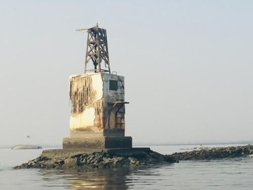
Date unknown (around 1980?). Active; focal plane 40 m (131 ft); four white flashes every 30 s. Approx. 40 m (131 ft) round cylindrical concrete tower with lantern and gallery, attached to a 1-story keeper's house. Lighthouse painted with black and white horizontal bands. Shah Mehran has the 2021 photo at right, an undated photo is available, Wikimedia has a photo taken about 1972, and Google has a good satellite view. This lighthouse is a landfall light for Port Qasim. Located on the west side of the island. Site and tower probably closed. Operator: Port Qasim Authority. ARLHS PAK-001; Admiralty D7760; NGA 28424.
Ahsan Channel Range Rear (Surveyor Sand)
Date unknown. Active; focal plane 31 m (102 ft); white light, occulting but the period is not listed. 31 m (102 ft) steel post with a large square gallery, mounted on a round concrete platform. No photo available and the light is not shown in Google's satellite view. This the principal approach range for Port Qasim. The front light is on a similar but much shorter tower. Located in the Arabian Sea about 3 km (2 mi) south of Bundle Island. Accessible only by boat. Site open, tower closed. Operator: Port Qasim Authority. Admiralty D7761; NGA 28428.
Phitti Creek Range Rear
Date unknown. Active; focal plane 20 m (66 ft); white light, 2 s on, 2 s off. 20 m (66 ft) steel post with a large square gallery, mounted on a round concrete platform. No photo available but Bing has a satellite view. This range guides vessels in Phitti Creek toward Port Qasim. The front light is on a similar but much shorter tower. Located in the creek off the northeast side of Bundle Island. Accessible only by boat. Site open, tower closed. Operator: Port Qasim Authority. Admiralty D7763.11; NGA 28441.1.
Kunni Range Rear
Date unknown. Active; focal plane 20 m (66 ft); white flash every 4 s. 20 m (66 ft) steel post with a large square gallery, mounted on a round concrete platform. No photo available but Bing has a satellite view. This range guides vessels in Phitti Creek toward Port Qasim. The front light is on a similar but much shorter tower. Located in the creek north of Buddo Island. Accessible only by boat. Site open, tower closed. Operator: Port Qasim Authority. Admiralty D7763.51; NGA 28442.1.


Khuddi Island Light, Port Qasim, May 2021
Google Maps photo by Shah Mehran

Hasan Point
Date unknown. Active; focal plane 10 m (33 ft); yellow flash every 4 s. 10 m (33 ft) round tower painted black with a green top. Google has an indistinct satellite view and a very distant street view. Located off a marshy point on the south side of Phitti Creek. Accessible only by boat. Site open, tower closed. Operator: Port Qasim Authority. Admiralty D7763.9; NGA 28445.
Hasan Point North
Date unknown. Active; focal plane 10 m (33 ft); continuous white light. 10 m (33 ft) round tower painted black with a red top. No photo available but Google has an indistinct satellite view. Located on the north side of Phitti Creek opposite Hasan Point. Accessible only by boat. Site open, tower closed. Operator: Port Qasim Authority. Admiralty D7763.91; NGA 28446.

City District Karachi Lighthouses
Bara Andai (Bara Anda, Oyster Rocks)
Date unknown. Inactive since 2015. 4.5 m (15 ft) concrete building; the light was displayed from a short mast. Saeed Faisal has a photo, Irshad Ahmed also has a photo, and Google has a satellite view. The Oyster Rocks are a group of small islands on the east side of the entrance to Karachi harbor. A new harbor basin is being developed in the area and the breakwaters for this basin enclose the Oyster Rocks. Located atop the largest and southernmost of the islands. Accessible only by boat. Site status unknown. Owner/site manager: Karachi Port Trust. ex-Admiralty D7752; ex-NGA 28488.
#Karachi (Range Rear)
Date unknown. Inactive since 2017 and since removed. This was a 20 m (66 ft) mast on a round platform supported by tripod piles. The tower is no longer seen in Bing's satellite view. This was the rear light of an approach range for Karachi, but the front light was discontinued in 2014. Located just outside the east breakwater of the new Oyster Rocks harbor basin. Accessible only by boat. Site status unknown. Operator: Karachi Port Trust. ex-Admiralty D7751.1; NGA 28480.
Karachi Container Port Range Front
2017. Active; focal plane 13 m (43 ft); green light occulting once every 5 s. Approx. 11 m (36 ft) square cylindrical skeletal tower. Swalay Muhammadi has a 2018 street view and Google has an indistinct satellite view. This is the modern approach range for Karachi, both the container port and the traditional port. Located near the end of the east breakwater of the new Oyster Rocks harbor basin. Site and tower closed. Site manager: Hutchison Ports Pakistan (South Asia Pakistan Terminals). Admiralty D7751.4.
Karachi Container Port Range Rear
2017. Active; focal plane 31 m (102 ft); green light occulting once every 5 s. Approx. 29 m (95 ft) square cylindrical skeletal tower. Google has a satellite view and a closeup street view (also seen at right). Located near the base of the east breakwater of the new Oyster Rocks harbor basin. Accessible by walking the pier. Site open, tower closed. Site manager: Hutchison Ports Pakistan (South Asia Pakistan Terminals). Admiralty D7751.6.
Karachi Harbour (Dockyard Training Wall)
Date unknown. Active; focal plane about 10 m (33 ft); white flash every 10 s. NGA lists a 5 m (16 ft) beacon, which is mounted on a robust square stone pier. No photo available but Google has a satellite view. Located at the south end of a breakwater opposite the Navy Dockyard on the east side of Karachi Harbour. Accessible only by boat. Site and tower closed. Admiralty D7754; NGA 28497.

Container Port Range Rear Light, Karachi, December 2018
Google Maps street view
* Manora Point (2)
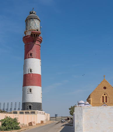
1889 (station established 1851). Active; focal plane 48 m (147 ft); white flash every 7.5 s. 38 m (125 ft) round stone tower with lantern and gallery. The seaward side of the lighthouse is painted with red and white horizontal bands, but the land side is unpainted. An excellent photo by Alexander Savin is at the top of this page, Zahid Shahid has a great photo and a second photo from the opposite side, Zahid Hussain Detho has a 2022 photo, Anser Sultan has a 2022 closeup of the land side, Atif Subhani has a photo of the builders' plaque, Huelse has a historic postcard view in which the tower is unpainted, and Google has a satellite view. The building next to the lighthouse is St. Paul's Church, built in 1850. The Manora Peninsula, formerly an island, faces the Arabian Sea and shelters the southwest side of Karachi Harbour, providing protection from summer monsoon winds. The British captured Manora in 1839 and made it their initial base of operations in what is now Pakistan. The lighthouse is located in the British historic district near the southeastern tip of the peninsula. Site open, tower closed. Operator: Karachi Port Trust. . ARLHS PAK-002; Admiralty D7750; NGA 28472.
#Manora Breakwater
Date unknown. Inactive since 2013 and later removed. 13 m (43 ft) triangular skeletal tower. Raja Islam has a 2007 view from the land end of the breakwater, a 2009 photo shows the tower still standing, and Google has a satellite view. In 2012-13 a new, much longer breakwater was constructed just west of the old one. Located at the end of the original west breakwater at Manora Point. Site open, tower closed. Owner: Karachi Port Trust. ex-Admiralty D7753; ex-NGA 28496.
New Manora Breakwater
2013. Active; focal plane 14 m (43 ft); white flash every 5 s. Approx. 8 m (26 ft) triangular skeletal tower. A closeup photo and a 2021 view are available and Google has an indistinct satellite view. Built in 2012-13, the new breakwater is twice the length of the old one. Located at the end of the new breakwater at Manora Point. Site open, tower closed. Owner: Karachi Port Trust. Admiralty D7750.5.

Karachi West District Lighthouses
Ras Muari (Cape Monze)
1914. Active; focal plane 49 m (161 ft); two white flashes every 10 s. 48 m (157 ft) round concrete tower. The seaward side of the tower is painted with black and white horizontal bands; the land side is unpainted. Original 2nd order Fresnel lens in use. Several keeper's houses and other light station buildings. Mudassir Nazir's photo is at right, Karim Usman has a 2008 photo, Abdul Hadi has a 2013 photo, and Google has a good satellite view. According to the Mercantile Marine Department this is a staffed lighthouse still operated manually. Ras Muari is a prominent cape at the southern end of the Kirthar Range, about 30 km (20 mi) west of Karachi on the border between Sindh and Balochistan. The lighthouse and the mountains behind it are a traditional landfall for ships arriving in Karachi from the west. Located just off the beach on the southwestern point of the cape. Site status unknown. Operator: Mercantile Marine Department. ARLHS PAK-003; Admiralty D7745; NGA 28500.


Ras Muari Light, Karachi, March 2021
Google Maps photo by Mudassir Nazir

Balochistan (Baluchistan) Province: Gwadar District Lighthouses

The semi-desert coast extending westward from Ras Muari into Iran is known historically as the Makran Coast.

Pasni Subdistrict Lighthouses
Ormara
1970. Active; focal plane 223 m (732 ft); two white flashes every 20 s. 11 m (36 ft) square steel skeletal tower. 1-story keeper's house. No photo available but Google has a satellite view of the station. Like Gwadar (see below), Ormara is in the lee of a hammerhead-shaped promontory. It is the location of the Jinnah Naval Base and there is a missile testing site nearby. Located at the east end of the steep-sided ridge sheltering the harbor of Ormara, about 240 km (150 mi) west of Karachi. Site status unknown. Operator: Mercantile Marine Department. ARLHS PAK-008; Admiralty D7742; NGA 28504.
Astola Island
1982. Active; focal plane 90 m (295 ft); white flash every 15 s. 10 m (33 ft) square cylindrical skeletal tower. Wikimedia has a very distant view by Sakina Nazia, a second distant view is available, and Google has a satellite view. Astola (also called Jezira Haft Talar) is an island about 40 km (25 mi) southeast of Pasni. It has no permanent population but there are temporary fishing camps on the island. In 2017 the island and its surroundings were declared a Marine Protected Area. Located atop a very steep bluff on the southwestern side of the island. Accessible only by boat. Site status unknown. Operator: Mercantile Marine Department. ARLHS PAK-005; Admiralty D7740; NGA 28508.
Pasni
1970. Active; focal plane 136 m (446 ft); three white flashes every 30 s. 11 m (36 ft) square steel skeletal tower. No photo available but Google has an indistinct satellite view. According to the Mercantile Marine Department, the lighthouse was "reconstructed" in 2000. Located on Jabal Zareen, a rugged promontory sheltering the harbor of Pasni, a small fishing port on the central coast of Baluchistan. Site status unknown. Operator: Mercantile Marine Department. Admiralty D7736; NGA 28512.

Gwadar Subdistrict Lighthouses
Gwadar is a port in the southwestern corner of Pakistan, east of the entrance to the Strait of Hormuz. The town was controlled by Oman from 1783 until 1958, when it was ceded to Pakistan in return for a large payment largely provided by the Aga Khan IV. The harbor is protected by Ras Nuh, a hammerhead-shaped promontory (actually an island connected to the mainland by a narrow isthmus).

Gwadar Range Front
Date unknown (probably 2002-05). Active; focal plane 32 m (105 ft); green light, 1 s on, 1 s off. Approx. 30 m (98 ft) round cylindrical concrete tower with a large round structure with two galleries on top; the light is displayed from a short mast on the roof. Lighthouse painted white with a red vertical stripe on the range line. Mohammad Iqbal's photo is at right, Ehisham Ghazi has a photo, another photo and a closeup photo are available, Wikimedia has a photo of the port that also shows the lighthouse, Moeed Rais has a street view, and Google has a satellite view. In 2002-05 Pakistan constructed a deepwater port at Gwadar, and the range lighthouses are part of that project. The port is sheltered by a tall ridge that is connected to the mainland by a narrow isthmus. Located near the base of the main quay at Gwadar. Site status unknown. Operator: Gwadar Port Authority. Admiralty D7734.3; NGA 28518.

Gwadar Range Front Lights, Gwadar, February 2019
Google Maps photo by Mohammad Iqbal
Gwadar Range Rear
Date unknown (probably 2002-05). Active; focal plane 45 m (148 ft); green flash every 3 s. Approx. 30 m (98 ft) round cylindrical concrete tower with winglike extensions near the top. Lighthouse painted white with a red vertical stripe on the range line; the "wings" presumably function as a daymark. Sohail Ahmed has a photo, Adeel Kadir has a distant view, Moeed Rais has a distant street view, and Google has a satellite view. Located about 800 m (1/2 mi) west of the front light, at the base of the mountain ridge. Site status unknown. Operator: Gwadar Port Authority. Admiralty D7734.35; NGA 28518.1.
Gwadar (Gwadur, Ras Nuh)
1970. Active; focal plane 85 m (279 ft); two white flashes every 15 s. 11 m (36 ft) square steel skeletal tower. Keeper's house. No photo available but Google has a satellite view of the station. Located on the heights of Ras Nuh. Site status unknown. Operator: Mercantile Marine Department. ARLHS PAK-006; Admiralty D7734; NGA 28516.
Jiwani
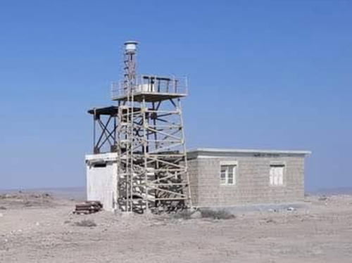
1970. Active; focal plane 140 m (459 ft); white flash every 10 s. 11 m (36 ft) square steel skeletal tower. Keeper's house. A 2021 photo is at right and Google has a satellite view. Located atop a steep bluff at the tip of the Daran peninsula, about 60 km (37 mi) west of Gwadar and 25 km (15 mi) east of the Iranian border. Site status unknown. Operator: Mercantile Marine Department. ARLHS PAK-007; Admiralty D7731; NGA 28520.

Information available on lost lighthouses:

  • Lightship Sindhi (1916). The fog bell from this lightship hangs at the Ras Muari (Cape Monze) lighthouse.

Jiwani Light, Jiwani, February 2021
Google Maps photo by ᴀᴘᴇx ᴘʀᴇᴅᴀᴛᴏʀ

Notable faux lighthouses:

Adjoining pages: East: Western Gujarat | West: Southeastern Iran

Return to the Lighthouse Directory index | Ratings key

Posted February 7, 2006. Checked and revised September 3, 2023. Lighthouses: 24. Site copyright 2023 Russ Rowlett and the University of North Carolina at Chapel Hill.