Lighthouses of Northern Iran

One of the largest countries of western Asia, the Islamic Republic of Iran has two coastlines. In the south it has a long and well known coastline facing the Gulf of Oman, Strait of Hormuz, and Persian Gulf. Less well known is that in the northwest of the country Iran has a coastline about 630 km (395 mi) long facing the southern end of the Caspian Sea (known in Iran as the Sea of Māzandarān).

Iran's Caspian coast is low and sandy, although the Alborz (Elburz) Mountains rise steeply to the south. In general the coastline lacks natural harbors; the one traditional harbor is Bandar-e Anzali at the mouth of the Sefid River near the west end of the coast. In modern times ports have been developed at Noshahr in the central part of the coast and Amirabad in the east.

Persian is the official language of Iran. The Persian phrase for a lighthouse is فانوس دریایی (fānoos daryaii). Jazīreh is an island, demaghh (nose) is a headland, rewdekhanh is a river, and bandar is a port or harbor.

Navigational aids in Iran are maintained by the Ports and Maritime Organization, an agency of the Ministry of Roads and Urban Development.

Because the Caspian Sea is landlocked its lights are not listed on the international light lists. The ARLHS list also does not include any lights of Iran's Caspian coast

General Sources
Iranian Ports
Information provided by the Ports and Maritime Organization.
Navionics Charts
Navigation chart for the Caspian Sea.
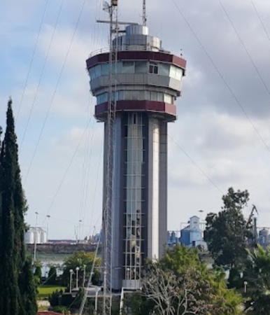
Anzali Light
Bandar-e Anzali Light, September 2008
ex-Panoramio photo copyright David Khani; permission requested
Gilan (Guilan) Province Lighthouses
Bandar-e Anzali is a city of about 150,000 residents. The only port of Gilan Province, the city is at the mouth of the Sefid River and the southwestern corner of the Caspian Sea, about 30 km (20 mi) northwest of the provincial capital of Rasht. It is Iran's oldest and still largest Caspian seaport. A larger harbor basin is under development
* Bandar-e Anzali
Date unknown. Active; focal plane about 50 m (164 ft); continuous (?) white light. Approx. 50 m (164 ft) harbor control tower with a 16-sided control and observation room and a radar antenna. The light is mounted on the gallery at the top of the building. The tower is gray concrete with dark red bands around the top and bottom of the control building. David Khani's photo is above, Alireza Zahiri Sorouri has a 2018 photo, Yaser Pourdavar has a closeup, and Google has a satellite view and a street view from the breakwater. Located on the west side of the harbor entrance near the base of the west breakwater. Site status unknown, but the tower is easily seen from nearby. Operator: Anzali Port.
* Anzali North Breakwater (2)
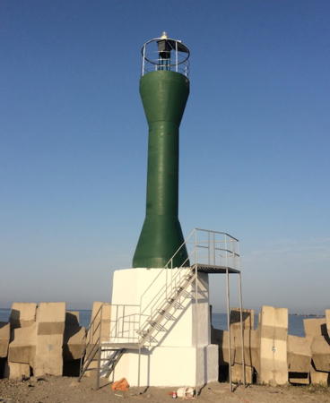
2016. Active; focal plane about 15 m (49 ft); green light, pattern unknown. Approx. 12 m (39 ft) round barbell-shaped green fiberglass tower mounted on a hexagonal white concrete base. Mostafao Alavi's 2016 photo is at right, a closeup photo is available, Vahid Tabatabaian has a 2017 street view, and Google has a satellite view. This light replaced a light on a green mast seen in Mohammad Namazi's 2015 street view. Located on the north (main) breakwater of Anzali harbor. Accessible by walking the pier. Site open, tower closed. Operator: Anzali Port.
* Anzali Inner Breakwater (Range Front)
Date unknown. Active (?); focal plane about 12 m (39 ft); green light, pattern unknown. Approx. 10 m (33 ft) square skeletal tower carrying a green triangular daymark, point up. Vahid Tabatabaian has a 2017 street view, Milad Raftari has a 2022 view from the harbor, and Google has a satellite view. This light appears to be the front light of a range; it may be an approach range that has the light on the control building as the rear light. New and much longer breakwaters have been built at Anzali, and probably they made the range obsolete. Located on the original west breakwater of Anzali. Accessible by walking the pier. Site open, tower closed. Operator: Anzali Port.
* Anzali Clock Tower
1815. Inactive as a lighthouse for many years but the tower is floodlit at night and is a prominent landmark. 28 m (92 ft) round brick tower with gallery, painted white with blue trim. Yaser Pourdavar has a photo, another photo is available, Emad Poursohrab has a night view, and Google has a satellite view. This historic building is well known as the symbol of Anzali. Built as a lighthouse, the tower was converted to a clock tower in 1928. It was restored in 1990 and another restoration is planned. Located about 160 m (520 ft) from the waterfront on the north side of downtown Anzali. Site open, tower status unknown.

North Breakwater Light, Bandar-e Anzali, July 2016
Google Maps photo by Mostafao Alavi
Anzali East Breakwater
Date unknown. Active; focal plane about 15 m (49 ft); red light, pattern unknown. Approx. 12 m (39 ft) red tower. M. Eskandari has a distant street view from the North Breakwater and Google has a distant satellite view. Located on the east breakwater of Anzali harbor. Site status unknown. Operator: Anzali Port.
Marina Caspian North Breakwater
Date unknown (recent). Active; focal plane about 10 m (33 ft); green light, pattern unknown. Approx. 8 m (26 ft) round cylindrical green concrete tower on a square concrete base. Shahrzad Najafipour has a closeup photo and Google has a satellite view and a very distant street view from the beach east of the marina. Marina Caspian is a recreational harbor on the east side of the new Caspian port. Located on the main breakwater of the marina. Site status unknown.
Marina Caspian East Breakwater
Date unknown (recent). Active; focal plane about 10 m (33 ft); red light, pattern unknown. Approx. 8 m (26 ft) round cylindrical red concrete tower on a square concrete base. Google has a street view and a satellite view. Located on the east (inner) breakwater of the marina. Site status unknown.
Cape Sefid-Rud
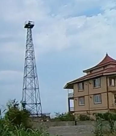
Date unknown. Active; focal plane about 50 m (164 ft); probably a white light, characteristic unknown. Approx. 40 m (131 ft) square pyrmidal skeletal tower with gallery. Vahid Tarighati has a 2016 photo (a portion is seen at right), Ehsan Alizadeh has a street view from the beach, and Google has a satellite view. Located on Cape Sefid-Rud, the only prominent cape on Iran's northern coast, about 50 km (30 mi) east of Bandar-e Anzali. Site status unknown.

Māzandarān Province Lighthouses
Māzandarān Province includes the north slope of the Alborz Mountains and more than half of Iran's Caspian coast. This is one of the most temperate and densely populated regions of Iran; the province's population is more than 3 million.

Noshahr (Nowshahr) West Breakwater
Date unknown. Active; focal plane about 12 m (39 ft); green light, pattern unknown. Approx. 6 m (20 ft) tower. The light is barely visible in PMO's photo of the harbor and Google has only a distant satellite view. Noshahr is a beach resort and university town of about 50,000 residents in Māzandarān Province, near the southernmost point of the Caspian Sea. Located at the end of the west breakwater at Noshahr. Site status unknown. Operator: Noshahr Port.

Cape Sefid-Rud Light, November 2016
ex-Google Plus photo by Vahid Tarighati
Noshahr (Nowshahr) East Breakwater
Date unknown. Active; focal plane about 12 m (39 ft); red light, pattern unknown. Approx. 6 m (20 ft) square pyramidal skeletal tower. The light is barely visible in PMO's photo of the harbor and Google has only a distant satellite view. A distant view of the harbor shows that there is a large skeletal tower beside the light. Located at the end of the east breakwater at Noshahr. Site status unknown but the light can be seen from the waterfront. Operator: Noshahr Port.
Fereydunkenar
Date unknown. Active; focal plane about 15 m (49 ft); light characteristic unknown. Approx. 7 m (23 ft) square skeletal tower carrying a rectangular daymark. A view from a nearby beach is available , the light is visible in Abolfazl Heydari's aerial view of the harbor, and Google has an indistinct satellite view. Located on the main (west) breakwater of Fereydunkenar, a county capital having about 35,000 residents.
Babolsar West Breakwater
Date unknown. Active; focal plane about 15 m (49 ft); green light, pattern unknown. Approx. 8 m (26 ft) square skeletal tower painted green. Maede Kardgar has a photo showing both Babolsar lighthouses, Arz Mohammadi's 2021 photo also shows both lighthouses, and Google has an indistinct satellite view. Located at the end of the west (main) breakwater at Babolsar, a small but historic port. The city has a population of about 75,000. Site status unknown.
Babolsar East Breakwater
Date unknown. Active; focal plane about 15 m (49 ft); red light, pattern unknown. Approx. 8 m (26 ft) square skeletal tower painted red. Maede Kardgar has a photo showing both Babolsar lighthouses, Arz Mohammadi's 2021 photo also shows both lighthouses, Mohammad Jafaripour has a 2022 street view, and Google has an indistinct satellite view. Located at the end of the east breakwater of Babolsar. Site status unknown.
* Babolsar
Date unknown. Active; focal plane about 15 m (49 ft); red light, pattern unknown. Approx. 8 m (26 ft) square skeletal tower painted red. Hovik Malians has the 2019 photo seen at right, Vahid Saberi has a photo, Mohammad Jafaripour has a 2022 street view, and Google has a satellite view. Located on a mound just east of the harbor entrance at Babolsar. Site open, tower closed.

Babolsar Light, Babolsar, November 2019
Google Maps photo by Hovik Malians
[Neka West Breakwater]
Date unknown. Active; focal plane about 12 m (36 ft); green light, pattern unknown. Approx. 6 m (20 ft) post with two galleries. A distant 2022 street view is available and Google has a distant satellite view. Neka is a city of about 45,000 residents. The harbor serves the Neka Power Plant, a large facility fueled by natural gas. Located on the east breakwater at Neka. Site status unknown.
[Neka East Breakwater]
Date unknown. Active; focal plane about 10 m (33 ft); red light, pattern unknown. Approx. 6 m (20 ft) post with two galleries. A 2022 street view is available and Google has a distant satellite view. Located on the east breakwater at Neka. Site status unknown.
Amirabad West Breakwater
Date unknown. Active; focal plane about 12 m (39 ft); green light, pattern unknown. Approx. 8 m (26 ft) square pyramidal concrete tower, painted green. No photo available but the shadow of the tower is visible in Google's satellite view. The Port of Amirabad is a modern port located 34 km (21 mi) northeast of the provincial capital of Sari. It is Iran's only port on the Caspian that is connected to the national railroad system, so it plays a major role in the country's international trade. Located at the end of the west breakwater of Amirabad. Site status unknown. Operator: Amirabad Port.
Amirabad East Breakwater
Date unknown. Active; focal plane about 12 m (39 ft); red light, pattern unknown. Approx. 8 m (26 ft) square pyramidal concrete tower, painted red. No photo available but the shadow of the tower is visible in Google's satellite view. Located at the end of the east breakwater of Amirabad. Site status unknown. Operator: Amirabad Port.

Golestan Province Lighthouse
* Bandar-e Gaz
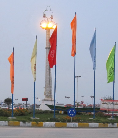
Date unknown. Reactivated (probably unofficial); focal plane about 30 m (98 ft); continuous white light. Approx. 26 m (85 ft) square concrete block pillar centered on a square concrete block base, with several large lights at the top of the pillar. M.Z. Mirzaei's photo is at right, a 2019 photo is available, and Google has a distant satellite view. The history of this structure is obscure; apparently it was built in the early 1900s to guide ships trading with Russia. It is identified on Google Maps as an "old lighthouse of the Qajar period"; the Qajar dynasty ruled Iran (then called Persia) from 1789 to 1925. Bandar-e Gaz is a town on the Gulf of Gorgan, a shallow lagoon at the southeastern corner of the Caspian Sea. Located on Pharos Square, a park on the waterfront of the town. Site open, tower closed.

Information available on lost lighthouses:

Bandar-e Gaz Light
Bandar-e Gaz Light, March 2010
ex-Panoramio photo copyright M.Z. Mirzaei; used by permission

Notable faux lighthouses:

Adjoining pages: Northeast: Turkmenistan | Northwest: Azerbaijan

Return to the Lighthouse Directory index | Ratings key

Posted August 5, 2011. Checked and revised July 13, 2023. Lighthouses: 17. Site copyright 2023 Russ Rowlett and the University of North Carolina at Chapel Hill.