Lighthouses of East and South Iceland

Iceland is an island nation in the North Atlantic roughly 800 km (500 mi) northwest of Scotland. Settled by Norse explorers around 870, Iceland has had a legislature since 930 and has generally functioned as a self-governing commonwealth, but for centuries it was also part of the Kingdom of Denmark. In 1918 Iceland was granted full autonomy and in 1944 it declared its independence as a republic.

This page includes lighthouses of two of Iceland's eight regions: Austurland (the east coast) and Suðurland (the south coast).

In Icelandic, the word for a lighthouse is viti (plural vitar); ey is an island, nes is a cape, and höfn is a harbor. The Icelandic alphabet includes the old Norse letters "eth" (Ð and ð) and "thorn" (Þ and þ), pronounced with the softer and harder forms of the th sound, respectively.

Lighthouses in Iceland are regulated by the Icelandic Transport Authority (Samgöngustofa, or ICETRA), which also maintains and operates the major coastal lights. Local port authorities operate harbor lights.

ARLHS numbers are from the ARLHS World List of Lights. VIT numbers are from the Vitaskrá, the official Icelandic light list. Admiralty numbers are from volume L of the Admiralty List of Lights & Fog Signals. U.S. NGA List numbers are from Publication 115.

General Sources
Sjóminjasafn Íslands - Vitar
Posted by the Icelandic Maritime Museum (Sjóminjasafn Íslands), this site has small photos and historical notes for Iceland's lighthouses.
Isländische Leuchttürme
Photos of 70 Icelandic lighthouses by Klaus Huelse.
Online List of Lights - Iceland
Photos by various photographers posted by Alexander Trabas. The photos for this area are by Ronald Wöhrn, Erich Hartmann, and Eckhard Meyer.
Lighthouse Pages from Anke and Jens - Iceland
Photos and accounts (in English).
Lighthouses in Iceland
Photos by various photographers available from Wikimedia.
Icelandic lighthouses / Íslenskir vitar
Flickr.com pool for photos of Icelandic lighthouses (well over 1000 photos).
World of Lighthouses - Iceland
Photos by various photographers available from Lightphotos.net.
Icelandic Lighthouse Society (Íslenska Vitafélagið)
An attractive web site with several photo galleries; primarily in Icelandic.
Vitaskrá 2023
The official Icelandic light list can be downloaded in pdf format. Published by Landhelgisgæsla Íslands, the Icelandic Coast Guard.
 
GPSNauticalCharts
Navigational chart information for Iceland.
Navionics Charts
Navigational chart for Iceland.


Knarrarós Light, Stokkseyri, May 2022
Google Maps photo by Matteo T
Austurland Lighthouses

Northern Austurland (Northeast Coast) Lighthouses
* Digranes
1947. Active; focal plane 28 m (92 ft); one long (1.5 s) flash every 20 s, white, red or green depending on direction. 19 m (62 ft) square cylindrical concrete tower with lantern and gallery. Lighthouse painted white with one black vertical stripe on each face, lantern painted red. A good 2009 photo is available, Sigurdur Jonsson has 2007 photo, Huelse has a photo, and Google has a satellite view. This is another lighthouse completed during World War II and activated after the war. Located on an islet just off a cape 3 km (2 mi) east of the fishing town of Bakkafjörður. A footbridge connects the islet to the mainland. Accessible from town by 4WD. Site open, tower closed. ARLHS ICE-033; VIT-207; Admiralty L4714; NGA 18908.
* Kolbeinstangi
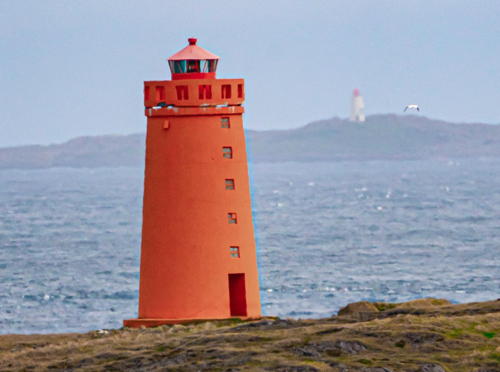
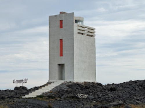
1942. Active; focal plane 24 m (79 ft); one long (2 s) flash every 10 s, white, red or green depending on direction. 19 m (62 ft) square cylindrical concrete tower with lantern and gallery. The design of the building makes it appear at a distance to have one or more black vertical stripes on each face. Kristinn Steinn Traustason's photo is at right, Trabas has Wöhrn's photo, Huelse has a photo, a distant view is available, and Google has a satellite view and a very distant street view. This is the leading light for the village of Vopnafjörður, located about 2 km (1.2 mi) northeast of the town. Accessible by road and a short hike (a visitor in 2020 found the access road chained). Site open, tower closed. ARLHS ICE-064; VIT-209; Admiralty L4716; NGA 18912.
Bjarnarey (2)
1944 (station estalished 1916). Active; focal plane 26 m (85 ft); three white flashes every 20 s. 7 m (23 ft) square cylindrical concrete tower with lantern and gallery. Lighthouse painted yellow, lantern red. Ingvar Hreinsson has a photo and Bing has a satellite view. There is another, better-known Bjarnarey in the Vestmanneyjar off the south coast. Located on Bjarnarey (Bear Island), a small island just off the cape Kollumúli, marking the south side of the entrance to the bay of Vopnafjörður. Accessible only by boat. Site open, tower closed. ARLHS ICE-030; VIT-214; Admiralty L4721; NGA 18916.
Kögur
1951. Active; focal plane 19 m (62 ft); flash every 15 s, white, red or green depending on direction. 8 m (26 ft) square cylindrical concrete tower with lantern and gallery. Lighthouse painted white, lantern red. Ingvar Hreinsson has a closeup photo and Google has a satellite view. Located on a cape about 5 km (3 mi) northwest of Bakkagerði. Accessible only by boat. Site open, tower closed. ARLHS ICE-109; VIT-215; Admiralty L4722; NGA 18960.

Kolbeinstangi Light, Vopnafjörður, July 2020
Google Maps photo by Kristinn Steinn Traustason
Glettinganes
1931. Active; focal plane 25 m (82 ft); two long (2 s) white flashes every 30 s. 20 m (66 ft) square concrete tower with lantern and gallery. Lighthouse painted yellow, lantern red. Ingvar Hreinsson has a 2001 photo, Einar Hansen has a 2008 aerial photo, and Google has a satellite view. Located on a very prominent cape about 12 km (7.5 mi) east of Bakkagerði. Probably accessible only by boat. Site open, tower closed. ARLHS ICE-040; VIT-220; Admiralty L4724; NGA 18964.
* Brimnes (3)
1938 (station established 1908). Active; focal plane 12 m (39 ft); two flashes every 10 s, white, red or green depending on direction. 7 m (23 ft) square cylindrical concrete tower with lantern and gallery. Lighthouse painted yellow, lantern red. Huelse has a photo, Trabas has Wöhrn's photo, and Bing has a distant satellite view. The original, temporary light was replaced by a lantern house imported from Norway in 1914. The Smyril Line cruise ship and ferry Norröna passes this lighthouse as it arrives in Seyðisfjörður on its voyages from Hirtshals, Denmark (this is the only ferry service to Iceland). Located on the north side of the entrance to Seyðisfjörður; accessible by 4WD from the town. Site open, tower closed. ARLHS ICE-031; VIT-221; Admiralty L4726; NGA 18968.
Dalatangi (1)
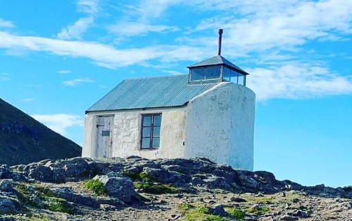
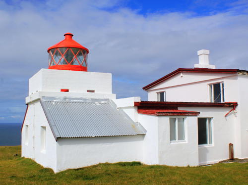
1895. Inactive since 1917. Approx. 5 m (17 ft) 1-story stucco-clad stone cottage with a small square lantern at one end. Lighthouse painted white, lantern red. Mustafa Bilal has the 2023 photo at right, Málfríður Guðmundsdóttir has a photo of both Dalatangi lighthouses, the Maritime Museum has a page for the lighthouse, and Eygló Haraldsdóttir has a good closeup photo. This is the oldest surviving lighthouse in eastern Iceland. Located about 100 m (110 yd) from the modern lighthouse. Site open, tower closed.


Old Dalatangi Lighthouse, Fjarðabyggð, November 2023
Google Maps photo by Mustafa Bilal

Dalatangi (3)
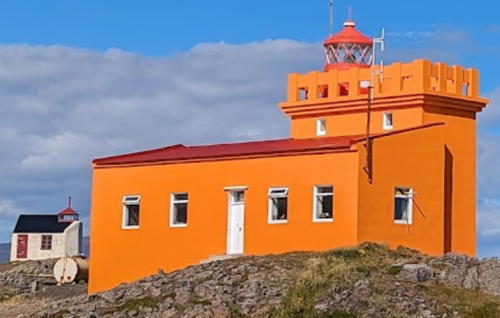
1959 (station established 1895). Active; focal plane 19 m (62 ft); white flash every 5 s. 10 m (30 ft) lantern and gallery atop a 1-1/2 story concrete keeper's house. Building painted yellow, lantern red. A 2023 photo is at right, Corinna de Marchi has a 2022 photo, Trabas has Renate Riedel's photo, Málfríður Guðmundsdóttir has a photo of both Dalatangi lighthouses, Huelse has a photo, another good photo is available, Ivar Orn Þórðarson has a closeup street view, and Google has a distant satellite view. This is a staffed coast guard station with several additional buildings and communications towers. The Smyril Line cruise ship and ferry Norröna passes this lighthouse as it arrives in Seyðisfjörður on its voyages from Denmark. Located on the prominent cape between the Seyðisfjörður and Mjóifjörður. Accessible by road, but it's a long trek by 4WD to reach this site. Site open, tower closed. ARLHS ICE-032; VIT-223; Admiralty L4730; NGA 18980.
Norðfjörður (Norðfjardar)
1952. Active; focal plane 39 m (128 ft); two flashes every 7 s, white or red depending on direction. 8 m (26 ft) square concrete tower with lantern and gallery. The tower was unpainted gray concrete for many years, but Google's August 2013 street view shows the entire lighthouse freshly painted white. Patrick Hoste has a 2023 photo, Trabas has Renate Riedel's photo, Huelse has a photo, Jóhann Þorsteinn Þórðarson has a photo of the rear of the building, and Google has a satellite view. Located on the east side of Neskaupstaður, at the north side of the entrance to the Norðfjörður; the lighthouse is at the extreme end of highway 92. Site status unknown. ARLHS ICE-069; VIT-225; Admiralty L4731; NGA 18988.


Old (left) and new Dalatangi Lighthouses, Fjarðabyggð, August 2023
Google Maps photo by Elios F


Central Austurland (East Coast) Lighthouses
Seley
1956. Active; focal plane 32 m (105 ft); three flashes every 25 s, white, red or green depending on direction. 14 m (46 ft) round concrete tower with lantern and gallery. Lighthouse painted white, lantern red. A closeup photo and a second photo are available, Trabas has Hartmut Knape's distant photo, Hlynur Ársælsson has a distant view, there's distant view of the lighthouse in the photo of Vattarnes Light at right, and Bing has a satellite view. This is Iceland's easternmost lighthouse. Located atop Seley, an island off the entrance to the Reyðarfjörður. Accessible only by boat. Site status unknown. ARLHS ICE-022; VIT-227; Admiralty L4733; NGA 19004.
* [Gríma]
1961. Active; focal plane 22 m (72 ft); white flash every 8 s. 3 m (10 ft) round lantern mounted an a square concrete base. Lantern painted red. Huelse has a photo, Trabas has Hartmut Knape's photo, and Bing has a distant satellite view. Located on a bluff on the south side of the Reyðarfjörður. A paved road passes close to the lighthouse, and the light is accessible by 4WD. Site status unknown. VIT-229; Admiralty L4735; NGA 19000.
* Vattarnes (2)
1957 (station established 1912). Active; focal plane 26 m (85 ft); two flashes every 15 s, white, red or green depending on direction. 12 m (39 ft) round concrete tower with lantern and gallery. Lighthouse painted yellow, lantern red. Veiga Gretarsdottir's 2022 photo is at right, Huelse has a photo, Trabas has Wöhrn's photo, Hlynur Ársælsson has a winter 2008 photo, Stephan Philipp has a 2023 view, and Google has a distant satellite view. Located on a prominent cape on the south side of the entrance to the Reyðarfjörður. Accessible by road. Site open, tower closed. . ARLHS ICE-053; VIT-228; Admiralty L4734; NGA 19008.
* Hafnarnes (2)
1937 (station established 1912). Active; focal plane 17 m (56 ft); one long (1.5 s) flash every 20 s. 6.5 m (21 ft) square cylindrical concrete tower with lantern and gallery. Lighthouse painted yellow, lantern red. A 2023 photo by Julien Jean Christophe Cesarini is at right, Wikimedia has Christian Bickel's 2010 photo, Trabas has Wöhrn's photo, Huelse has a closeup photo, a 2023 photo is available, and Google has a satellite view and a distant street view. Stone ruins next to the present lighthouse are the remains of the 1912 lighthouse. Located on a prominent cape on the south side of the entrance to the Fáskrúðsfjörður. Accessible by road (highway 96). Site open, tower closed. . ARLHS ICE-045; VIT-232; Admiralty L4738; NGA 19016.
* Landahóll
1953. Active; focal plane 26 m (85 ft); flash every 4 s, white, red or green depending on direction. 8 m (26 ft) square concrete tower with lantern and gallery. The entire lighthouse is painted white, which is unusual for Iceland. Huelse has a photo, Trabas has Wöhrn's photo, and Google has a satellite view and a distant street view. Located on a prominent cape on the north side of the entrance to the Stöðvarfjörður, about 3 km (2 mi) east of the town of the same name. Accessible by road; there's also a distant view from the Kambanes lighthouse (next entry) on the other side of the fjord. Site open, tower closed. ARLHS ICE-066; VIT-235; Admiralty L4743; NGA 19020.
* Kambanes
1922. Active; focal plane 35 m (115 ft); four flashes every 20 s, white, red or green depending on direction. 11 m (36 ft) square cylindrical concrete tower with lantern and gallery. Lighthouse painted yellow, lantern red. Huelse has a closeup photo, Trabas has Wöhrn's distant view, another distant view is available, and Google has a fuzzy satellite view. Located on a promontory 5 km (3 mi) east of Breiðdalsvik. Accessible by road and a short hike down to the tower. Site open, tower closed. ARLHS ICE-059; VIT-236; Admiralty L4744; NGA 19024.
* Selnes (Breiðdalsvik)
1942. Active; focal plane 12.5 m (41 ft); flash every 8 s, white, red or green depending on direction. 9 m (30 ft) rectangular cylindrical concrete tower with gallery; the light is shown through a window at the top of the tower. Formerly unpainted gray concrete, the lighthouse is now painted red. Huelse has a photo, Trabas has Wöhrn's closeup photo, another closeup is available, Mustafa Bilal has a 2023 photo, and Google has a satellite view. Located on a sharp promontory at the east side of the entrance to the harbor of Breiðdalsvik. Site open, tower closed. ARLHS ICE-078; VIT-237; Admiralty L4746; NGA 19028.


Vattarnes and Seey Lights, Fjarðabyggð, May 2022
Instagram photo by Veiga Gretarsdottir


Hafnarnes Light, Fjarðabyggð, August 2023
Instagram photo by Julien Jean Christophe Cesarini

* Streiti (Streitishvar) (2)
1984 (station established 1922). Active; focal plane 22 m (72 ft); three flashes every 20 s, white, red or green depending on direction. 12 m (39 ft) octagonal cylindrical tower with lantern and gallery. The eight faces of the tower are painted alternately black and white, creating vertical stripes; lantern and gallery painted white. Trabas has Wöhrn's closeup photo, Gabor Burkhardt has a 2021 photo, Huelse has a good photo, the Maritime Museum has a page for the lighthouse, Óskar Ragnarsson has a distant view, Lightphotos.net has a good photo, Google has a street view, and Bing has a satellite view. The original lighthouse at this station was demolished in 1958 and replaced by a light on the island of Hlöðu. The present lighthouse was built when the Hlöðu lighthouse was destroyed by a storm in January 1984. Located just off highway 1 on a prominent cape about 8 km (5 mi) south of Breiðdalsvik. Accessible from the coastal highway. Site open, tower closed. . ARLHS ICE-089; VIT-241; Admiralty L4749.2; NGA 19044.

Southern Austurland (Southeast Coast) Lighthouses
* Karlstaðatangi
1922. Active; focal plane 10 m (33 ft); two white flashes every 10 s, white, red or green depending on direction. 8 m (26 ft) square cylindrical concrete tower with lantern and gallery. Lighthouse painted yellow, lantern red. Trabas has Wöhrn's photo, Hjörtur Sólrúnarson has a 2022 photo, Huelse has a distant photo, and Google has a distant satellite view. Located on the north side of the entrance to the Berufjörður, opposite Djúpivogur. Accessible from the coastal highway. Site open, tower closed. . ARLHS ICE-060; VIT-242; Admiralty L4750; NGA 19052.
* Æðarsteinn (Djúpivogur)
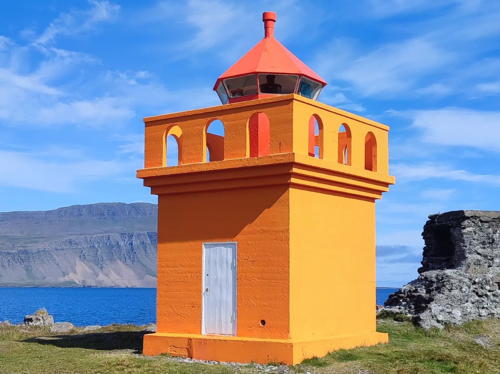
1922. Active; focal plane 10 m (33 ft); flash every 5 s, white, red or green depending on direction. 6 m (20 ft) square cylindrical concrete tower with lantern and gallery. Lighthouse painted yellow, lantern red. Mustafa Bilal's 2023 photo is at right, Wikimedia has Christian Bickel 2010 photo, Trabas has Meyer's photo, Emily Turney has a 2018 photo, Huelse has a distant photo, the Maritime Museum has a page for the lighthouse, Chris Whittleston has a street view, and Google has a distant satellite view. Until the 1970s, the lighthouse was painted with red and white horizontal bands. Located on a rocky point on the west side of the harbor of Djúpivogur. Site open, tower closed. . ARLHS ICE-115; VIT-243; Admiralty L4754; NGA 19056.
Ketilfles (Ketilbodafles)
1946. Active; focal plane 20 m (66 ft); three flashes every 15 s, white, red or green depending on direction. 13 m (43 ft) round concrete tower with lantern and gallery. Lighthouse painted white, lantern red. Ingvar Hreinsson has a closeup photo, Trabas has Jim Smith's photo, Mustafa Bilal has a 2023 drone view, and Google has a distant satellite view. Located on an island about 2 km (1.2 mi) offshore southeast of Djúpivogur and 2.5 km (1.5 mi) west northwest of Papey. Accessible only by boat. Site status unknown. ARLHS ICE-061; VIT-249; Admiralty L4760; NGA 19076.
Papey
1922. Active; focal plane 57 m (187 ft); flash every 10 s, white, red or green depending on direction. 8 m (26 ft) square cylindrical concrete tower with lantern and gallery. Lighthouse painted yellow, lantern red. A photo and a closeup are available, Mustafa Bilal has a 2023 photo, Trabas has Jim Smith's distant view, and Google has a distant satellite view. Located at the highest point of Papey, an island about 4 km (2.5 mi) offshore southeast of Djúpivogur. The island is named for the Irish monks (papar) who (according to legend) were living there when the Norse arrived in the ninth century. There have been no permanent inhabitants since 1966, but there are several summer homes on the island. Accessible only by boat. Site open, tower closed. ARLHS ICE-017; VIT-250; Admiralty L4762; NGA 19048.

Æðarsteinn Light, Djúpivogur, September 2023
Google Maps photo by Mustafa Bilal
* Hvalnes
1954. Active; focal plane 29 m (95 ft); two white flashes every 20 s. 12 m (39 ft) square cylindrical concrete tower with lantern and gallery. Lighthouse painted yellow, lantern red. A 2023 photo is at right, the Maritime Museum has a page for the lighthouse, Huelse has a closeup photo, Trabas has Wöhrn's photo, Lightphotos.net has a good photo, Martin Čáp has a 2020 photo, Ar Yin has a beautiful 2023 drone view, and Google has a satellite view and a distant street view. A communications tower stands beside the light. This important lighthouse marks a prominent cape, the Austerhorn, one of two capes that mark the southeastern corner of Iceland. Accessible from the coastal highway IS-1. Site open, tower closed. . ARLHS ICE-055; VIT-251; Admiralty L4764; NGA 19080.
Stokksnes (2)
1946 (station established 1922). Active; focal plane 30 m (98 ft); three flashes every 30 s, white, red or green depending on direction. 19 m (62 ft) square concrete tower with lantern and gallery. Lighthouse painted white, lantern red. Trabas has Wöhrn's photo, Huelse has a closeup photo, Meagan Wey has a 2021 photo, and Google has a satellite view. A communications tower stands beside the light. This important lighthouse marks a prominent cape, the Vesterhorn, one of two capes that mark the southeastern corner of Iceland. Site and tower closed (the lighthouse is on the grounds of a NATO radar station). . ARLHS ICE-085; VIT-252; Admiralty L4766; NGA 19084.
Hellir
1954. Active; focal plane 15 m (49 ft); three flashes every 15 s, white, red or green depending on direction. 6 m (20 ft) trapezoidal cylindrical concrete tower with lantern and gallery. Lighthouse painted white with blue trim. Trabas has Wöhrn's photo, Jutta Ingala has a view from the sea, a 2022 drone view is available, and Google has a satellite view. Located on an island in the Hornafjörður, marking a segment of the channel leading to Höfn. Accessible only by boat. Site open, tower closed. VIT-254; Admiralty L4768.4; NGA 19096.
Hvanney (Höfn)
1922 (heightened in 1938). Active; focal plane 15 m (49 ft); flash every 5 s, white, red or green depending on direction. 8 m (26 ft) square cylindrical concrete tower with lantern and gallery. Lighthouse painted yellow, lantern red. Trabas has Wöhrn's photo, Huelse has a distant photo, Ólafur Ólafsson has another distant view, and Google has a satellite view. Hvanney is a barrier island off the southeast coast of Iceland; the lagoon behind the barrier is called the Hornafjörður. Located at the east end of the island, marking the south side of the entrance to the lagoon about 1.5 km (1 mi) south of Höfn. Accessible only by boat, although there is a distant view from the town. Site open, tower closed. ARLHS ICE-056; VIT-253; Admiralty L4768; NGA 19088.

Hvalnes Light, Austur-Skaftafellssýsla, October 2023
Instagram photo by sushideluxe
Suðurfjörutangi Entrance Range Rear
Date unknown. Active; focal plane 8 m (26 ft); flash every 1.5 s, white, red or green depending on direction. 4 m (13 ft) round white concrete tower with lantern. No photo available but Google has a satellite view. This is the entrance range for Höfn, a fishing port of about 2500 residents. Located on the south side of the fjord about 300 m (0.2 mi) west of the Hvanney lighthouse. Accessible only by boat, although there is a distant view from the town. Site open, tower closed. VIT-256; Admiralty L4768.21; NGA 19092.1.
Hrollaugseyjar
1954. Active; focal plane 27 m (89 ft); one long (1.5 s) white flash every 30 s. 16 m (52 ft) round concrete tower with lantern and gallery. Lighthouse painted white, lantern roof red. Sigurbjörn Árnason has a very distant view of the island and lighthouse, Trabas has a very distant view by Werner Furlan, and Bing has a satellite view. Hrollaugseyjar is one of a group of small, rocky islands about 5 km (3 mi) offshore and 25 km (15 mi) southwest of Höfn. Accessible only by boat. Site status unknown. ARLHS ICE-010; VIT-262; Admiralty L4770; NGA 19100.

Suðurland Lighthouses

Southeastern Suðurland (Central South Coast) Lighthouses
Ingólfshöfði (2)
1948 (station established 1916). Active; focal plane 79 m (259 ft); two white flashes every 10 s. 12.5 m (41 ft) square cylindrical masonry tower with lantern and gallery. Lighthouse painted yellow, lantern painted red. A fine closeup photo and a second photo are available, Mustafa Bilal has a 2023 closeup, and Google has a distant satellite view. The islet is named for Ingólfur Arnarson, the legendary first Norse settler of Iceland, who landed here in 874. Located on an islet off a prominent cape about 20 km (13 mi) south of Fagurhólsmyri. This is a remote area and there may not be any land access. Site open, tower closed. ARLHS ICE-057; VIT-263; Admiralty L4772; NGA 19104.
Skaftárós (2)
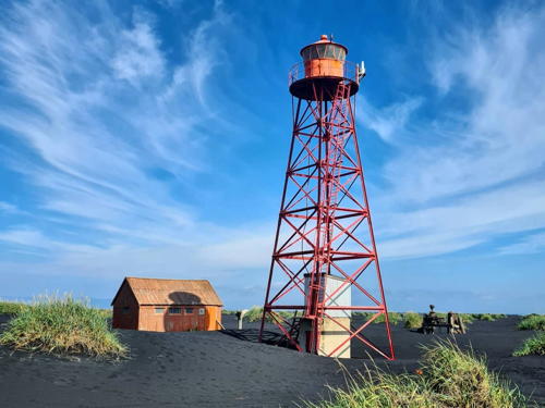
1911 (relocated here in 1953). Active; focal plane 21 m (69 ft); white flash every 3 s. 19.5 m (64 ft) square pyramidal steel skeletal tower with lantern and gallery. Entire lighthouse painted red. 1-1/2 story keeper's house. Magnús Bollason's 2021 photo is at right, Jón Kornílius Gíslason has a 2008 photo, Pall Asmundsson has a closeup, and Bing has a distant satellite view. Prefabricated in Copenhagen, this is Iceland's oldest skeletal lighthouse. According to the Maritime Museum, it was first installed at Rifstanga á Melrakkasléttu in northeastern Iceland. Located at the eastern entrance to the Skaftárós lagoon, in a remote area of the south coast about 70 km (45 mi) east of Vík. Accessible only by boat. Site open, tower closed. . ARLHS ICE-081; VIT-264; Admiralty L4774; NGA 19108.
 

Skaftárós Light, Vík, August 2021
Instagram photo by Magnús Bollason
 
Skarðsfjara
1959. Active; focal plane 25 m (82 ft); four white flashes, in a long-short-long-short pattern, every 30 s. 22 m (72 ft) square pyramidal steel skeletal tower with lantern and gallery. Entire lighthouse painted red. 1-story keeper's house. Mustafa Bilal has a 2023 photo, Gunnlauger Hólm Torfason has a 2009 photo, and Bing has a satellite view. Located at a bend in the coastline about 30 km (20 mi) east of Myrar. This is a remote area and there may not be any land access. Site open, tower closed. ARLHS ICE-084; VIT-265; Admiralty L4775; NGA 19112.
Alviðruhamrar
1929. Active; focal plane 33 m (108 ft); three white flashes, in a short-long-short pattern, every 20 s. 20.5 m (68 ft) square concrete tower with lantern and gallery. Lighthouse painted yellow, lantern red. Mustafa Bilal has a good 2023 photo, Ingvar Hreinsson has a photo showing repainting in progress in 2008, Sigmar Þór Sveinbjörnsson has a similar photo, and Bing has a satellite view. Another Hreinsson photo shows the isolation of this lighthouse. Located on the west side of the Küðafljot, a glacial melt river, about 15 km (9 mi) south of Myrar. This is a remote area and there may not be any public land access. Site open, tower closed. ARLHS ICE-027; VIT-266; Admiralty L4776; NGA 19116.
* Dyrhólaey (2)
1927 (station established 1910). Active; focal plane 118 m (387 ft); white flash every 10 s. 13 m (43 ft) square cylindrical masonry tower with lantern and gallery, rising from the center of a 1-story keeper's cottage. Lighthouse painted white with red trim, lantern painted red. Jonathan Munin's 2022 photo is at right, Wikimedia has Diego Delso's 2014 photo, the Maritime Museum has a page for the lighthouse, Matt Riggott has a 2007 closeup, Huelse has a photo, Trabas has Andreas Köhler's closeup photo, Tryggvi Gunnarsson has a good 2008 photo, Lightphotos.net has a photo, and Google has a street view and a satellite view. This is probably the best known lighthouse of southern Iceland. In 2016 Icelandair Hotels renovated the building as a luxury accommodation. However the lighthouse is no longer on the hotel chain's web site. Dyrhólaey ("door hole") is a steep promontory into which the sea has eroded a large arch. The area is a nature preserve and a very popular tourist destination but it is closed during the bird nesting season in May and June. The lighthouse is on the mainland a short distance northwest of the arch. The first lighthouse was a skeletal tower prefabricated in Sweden. Accessible by road off the coastal highway about 10 km (6 mi) west of Vík. Site open (except May and June), tower open to hotel guests. Site manager: unknown. . ARLHS ICE-034; VIT-267; Admiralty L4780; NGA 18040.

Dyrhólaey Light, Vík, September 2022
Google Maps photo by Jonathan Munin

Vestmannaeyjar Lighthouses

The Vestmannaeyjar (Westman Islands) are a small archipelago a short distance off the south coast. Heimaey (Home Island) is the largest island and the only inhabited island. The permanent population is about 4500. Heimaey is accessible by air from Reykjavík or by a daily ferry from Þorlákshöfn.
* Stórhöfði (Heimaey) (2)
1906. Active; focal plane 125 m (410 ft); three white flashes every 20 s. 7 m (23 ft) lantern and gallery mounted on the seaward end of a 2-story keeper's house. The house is occupied by Iceland's last full-time light keeper, Oskar Jakob Sigurdsson, who inherited the assignment from his father in 1965. Lighthouse painted white with red trim, lantern painted red. A photo by János Palotás is at right, Julia Paevska has a 2018 photo, Trabas has Renate Riedel's photo, Manuel Steinmair has a distant street view, and Google has a satellite view. The 100th anniversary of the lighthouse was celebrated in November 2006. Located on the southern tip of Heimaey. Accessible by road. Site open, tower closed. ARLHS ICE-086; VIT-268; Admiralty L4784; NGA 18044.
* Urðir (Urdir, Vestmannaeyjar) (2)
1986 (station established 1925). Active; focal plane 30 m (98 ft); three flashes every 15 s, white, red or green depending on direction. 7 m (23 ft) lantern and gallery supported by two piles and a concrete stairway. Entire lighthouse painted white. Eydís Eyjólfsdóttir has a closeup photo, Georgia Ceriani has another closeup, Trabas has Renate Riedel's photo, Mand Google has a satellite view. The original lighthouse was destroyed by the volcanic eruption of 1973. Located on the eastern point of Heimaey. Accessible by hiking down from a nearby road. Site open, and visitors can climb the stairs to the gallery. ARLHS ICE-093; VIT-270; Admiralty L4786; NGA 18048.
* Heimaey Höfn
Date unknown. Active; focal plane 10 m (33 ft); red flash every 2 s. 6 m (20 ft) skeletal tower mounted atop a 1-story concrete equipment shelter. Lighthouse painted yellow. A 2008 photo is available, Trabas has Renate Riedel's closeup photo, David Ng has a 2022 photo, Davíð í Tölvun has a 2020 street view, and Google has a satellite view. Located at the end of the east mole of Heimaey harbor. Site open, tower closed. VIT-273; Admiralty L4790; NGA 18060.

Stórhöfði Light, Heimaey, August 2015
ex-Google Plus photo by János Palotás
Faxasker
1950. Active; focal plane 14 m (46 ft); white flash every 7 s. 6 m (20 ft) post mounted atop a 1-story concrete equipment shelter. Lighthouse painted yellow. A photo is available, Sigmar Þór Sveinbjörnsson reports on a visit to the light, Karl Marteinsson has a distant view, and Google has a satellite view. Located on a small island in the Vestmannaeyjar, about 2 km (1.2 mi) north of Heimaey. Accessible only by boat. Site open, tower closed. ARLHS ICE-036; VIT-269; Admiralty L4782; NGA 18068.
Þrídrangar (Thridrangur)
1939. Active; focal plane 34 m (112 ft); long white flash followed by a short white flash every 30 s. 4 m (13 ft) square concrete tower with lantern and gallery. Lighthouse painted white, lantern red. Ingvar Hreinsson has a closeup photo, Sigmar Þór Sveinbjörnsson has a photo, Michael Poliza has an aerial view, and Steve Fernie has a distant view from the sea, but the islet is not seen in Google's satellite view. Photos and videos of this isolated and "terrifying" lighthouse suddenly went viral in July 2016. Located on the largest of three isolated rocks about 13 km (8 mi) west northwest of Heimaey. Accessible only by helicopter (with an experienced pilot). VIT-278; Admiralty L4802; NGA 18080.

Western Suðurland (Southwest Coast) Lighthouses
* Knarrarós
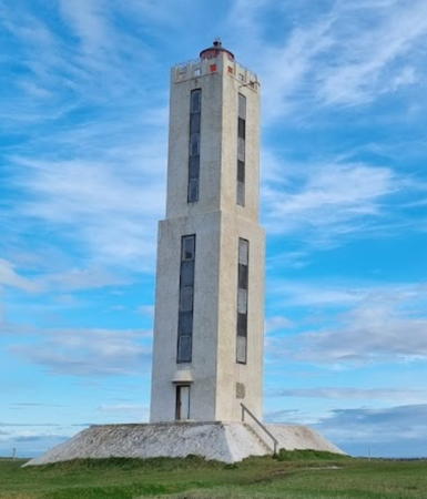
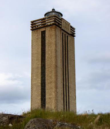
1939. Active; focal plane 30 m (98 ft); one very long (3 s) flash every 30 s. 22 m (72 ft) square cylindrical 2-stage concrete tower with lantern and gallery. The tower is unpainted concrete, but black panels between windows give the tower the appearance of a black vertical stripe on each face; lantern painted black. A 2022 photo is at the top of this page, Seli Oskarsson has a nice 2008 photo, Sascha van Berkum has a 2022 photo, Trabas has Wöhrn's photo, Huelse has a photo, Thorir Sigurgeirsson has another photo, and Google has a satellite view and a distant street view. Located on a point of land about 5 km (3 mi) east of Stokkseyri. Site open, tower closed. . ARLHS ICE-012; VIT-279; Admiralty L4804; NGA 18116.
Þorlákshöfn South Breakwater
Date unknown. Active; focal plane 13 m (43 ft); red flash every 3 s. 4 m (13 ft) post atop a 1-story equipment building. Building painted yellow. Trabas has a photo and Google has a satellite view. Located at the end of the main breakwater of Þorlákshöfn (Thorlákshöfn). Site and tower closed. VIT-296.3; Admiralty L4823; NGA 18120.
* Þorlákshöfn (Thorlákshöfn, Hafnarvik)
1951. Active; focal plane 11 m (36 ft); white flash every 3 s. 8 m (26 ft) 3-story square concrete tower with a lantern in the seaward side of the top floor. The lighthouse is unpainted white concrete. A 2023 photo by David Cousins is a right, Trabas has Wöhrn's photo, Huelse has a photo, a 2022 closeup is available, and Google has a distant street view and a satellite view. This modern tower stands at the tip of the peninsula sheltering the harbor of Þorlákshöfn (Thorlákshöfn). Accessible by road. Site open, tower closed. ARLHS ICE-106; VIT-294; Admiralty L4820; NGA 18132.
* Selvogur (2)
1931 (station established 1919). Active; focal plane 20 m (66 ft); two white flashes every 10 s. 15 m (49 ft) square cylindrical concrete tower with lantern and gallery. Tower painted orange, lantern and gallery red. Trabas has Wöhrn's photo, Huelse has a photo, Neil Anstey has a 2019 photo, Brynja Hrafnkelsdóttir has a 2008 photo, and Bing has a satellite view. The first lighthouse was a skeletal tower. The present lighthouse was renovated and repainted in 2008. Located at Selvogur, a village about 25 km (15 mi) west of Thorlákshöfn. Site open, tower closed. ARLHS ICE-079; VIT-297; Admiralty L4824; NGA 18136.

Þorlákshöfn Light, Þorlákshöfn, August 2023
Google Maps photo by David Cousins

Information available on lost lighthouses:

Notable faux lighthouses:

Adjoining pages: North: Northern Iceland | West: Western Iceland

Return to the Lighthouse Directory index | Ratings key

Posted October 17, 2006. Checked and revised April 11, 2024. Lighthouses: 41. Site copyright 2024 Russ Rowlett and the University of North Carolina at Chapel Hill.