Lighthouses of Western Iceland

Iceland (Ísland in Icelandic) is an island nation in the North Atlantic roughly 800 km (500 mi) northwest of Scotland and 970 km (600 mi) east of Norway. Settled by Norse explorers around 870, Iceland has had a legislature since 930 and has generally functioned as a self-governing commonwealth, but for centuries it was also part of the Kingdom of Denmark and Norway. In 1918 Iceland was granted full autonomy by Denmark and in 1944 it declared its independence as a republic.

Iceland sits on Mid-Atlantic Ridge, the geologic boundary between Europe and North America, and at the maritime boundary between the North Atlantic Ocean and the Arctic Ocean. The coast of Iceland is cut by numerous fjords. Reykjavík, the capital, is also the only large port, but there are many smaller fishing ports all around the ccircumference of the island.

This page includes lighthouses of three of Iceland's eight regions: Suðurnes (the southwestern, or Reykjanes, peninsula), Höfuðborgarsæði (the capital region, including Reykjavík), and Vesturland (the west coast).

In Icelandic the word for a lighthouse is viti (plural vitar); ey is an island, rif is a reef, nes is a cape, vík or flói is a bay, fjörð is a firth or fjord, sund is a strait, ána is a river, and höfn is a harbor. The Icelandic alphabet includes the old Norse letters "eth" (Ð and ð) and "thorn" (Þ and þ), pronounced with the softer and harder forms of the English th sound, respectively.

Lighthouses in Iceland are regulated by the Icelandic Transport Authority (Samgöngustofa, or ICETRA), which also maintains and operates the major coastal lights. Local port authorities operate harbor lights.

ARLHS numbers are from the ARLHS World List of Lights. VIT numbers are from the Vitaskrá, the official Icelandic light list. Admiralty numbers are from volume L of the Admiralty List of Lights & Fog Signals. U.S. NGA List numbers are from Publication 115.

General Sources
Sjóminjar Íslands - Vitar
Posted by the Icelandic Maritime Museum (Sjóminjar Íslands), this site has small photos and historical notes for Iceland's lighthouses.
Isländische Leuchttürme
Photos of 70 Icelandic lighthouses by Klaus Huelse.
Online List of Lights - Iceland
Photos by various photographers posted by Alexander Trabas. The photos for this area are by Ronald Wöhrn, Capt. Peter Mosselberger (Capt. Peter), and Erich Hartmann.
Lighthouse Pages from Anke and Jens - Iceland
Photos and accounts (in English).
Iceland Lighthouses
Photos on Flickr.com taken in 2011 by Larry Myhre.
Lighthouses in Iceland
Photos by various photographers available from Wikimedia.
Icelandic lighthouses / Íslenskir vitar
Flickr.com pool for photos of Icelandic lighthouses (roughly 1900 photos).
World of Lighthouses - Iceland
Photos by various photographers available from Lightphotos.net.
Icelandic Lighthouse Society (Íslenska Vitafélagið)
An attractive web site with several photo galleries; primarily in Icelandic.
Vitaskrá 2023
The official Icelandic light list can be downloaded in pdf format. Published by Landhelgisgæsla Íslands, the Icelandic Coast Guard.
Iceland Map and Satellite Image
From Geology.com.
GPSNauticalCharts
Navigational chart information for Iceland.
Navionics Charts
Navigational chart for Iceland.


Reykjanes Light, Grindavík, March 2024
Google Maps photo by Krzysztof Kłyczek

Suðurnes Region (Reykjanes Peninsula) Lighthouses

The Reykjanes Peninsula, southwest of Reykjavík, is about 50 km (30 mi) long and 8-10 km (5-6 mi) wide. It ends at Reykjanes, the southwestern tip of Iceland. The peninsula is an actively volcanic area with many hot springs and steam vents, because it lies over the boundary between the Eurasian and North American Plates. North of Reykjanes the Bridge Between Continents, a 15 m (50 ft) long footbridge, crosses a rift valley about 18 m (60 ft) wide that is considered to mark the continental boundary.

South Coast Lighthouses
* Krísuvíkurberg
1965. Active; focal plane 60 m (197 ft); white flash every 10 s. 5 m (16 ft) round lantern on a round cylindrical metal tower. Lantern painted red and the lower part of the tower painted yellow. Trabas has Renate Riedel's photo, Stefán Þorvaldsson has a 2008 closeup photo, another photo is available, and Bing has a satellite view. Located on a bluff at Krísuvíkurberg, about 25 km (15 mi) east of Grindavík. Accessible by 4WD. Site open, tower closed. VIT-298; Admiralty L4826; NGA 18140.
* Hópsnes
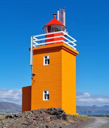
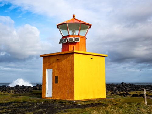
1928. Active; focal plane 16 m (52 ft); three long (2 s) white flashes every 20 s. 8 m (26 ft) square cylindrical concrete tower with lantern and gallery. Tower painted orange, lantern and gallery red. A photo by Agata Latos is at right, Trabas has Wöhrn's photo, Petr Weiss has a 2023 photo, Huelse has a photo, Ásmundur Þorkelsson has a good closeup, and Google has a street view and a satellite view. Located on a promontory about 2.5 km (1.5 mi) southeast of Grindavík. Site open, tower closed. . ARLHS ICE-048; VIT-299; Admiralty L4828; NGA 18144.
Grindavík No. 1 (Center) Range Rear
Date unknown. Active; focal plane about 20 m (66 ft); green light occulting once every 5 s. 17 m (59 ft) triangular skeletal tower carrying a triangular white daymark point down. Trabas has a photo and Google has a street view, but the slender tower is hard to see in Google's satellite view. This is the entrance range for Grindavík, a fishing port with about 3300 residents. The front light is on a similar tower 10 m (33 ft) tall. Located on the Seljabót one block north of the waterfront in Grindavík. Site open, tower closed. VIT-301; Admiralty L4833.1; NGA 18160.

Hópsnes Light, Grindavík, March 2020
Instagram photo by Agata Latos
* Reykjanes (3)
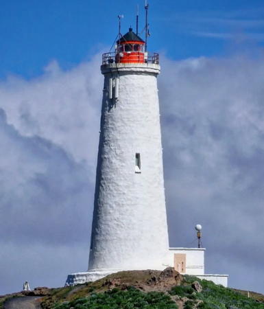
1929 (station established 1879). Active; focal plane 73 m (240 ft); two white flashes every 30s. 31 m (102 ft) round concrete tower with lantern and gallery. Tower painted white, lantern red. The modern 2-story keeper's house is occupied by a resident attendant. Krzysztof Kłyczek's 2024 photo is at the top of this page, Trabas has Wöhrn's excellent photo, Huelse has a good photo, Anke and Jens have a page for the lighthouse, Wikimedia has photos, Ofek Levi has a 2022 photo, and Google has a satellite view and a wintry street view. This light station, Iceland's oldest, is the landfall light for Keflavík and Reykjavík. The original lighthouse stood only eight years before being destroyed by an earthquake in 1887. Traditional in appearance, the current tower is probably Iceland's best known and most visited lighthouse. The area around the lighthouse is thermally active, and plumes of steam can often be seen in photos of the lighthouse. Located atop a hill (an inactive volcanic cone) near the southwestern point of the Reykjanes peninsula, about 16 km (10 mi) west of Grindavík and 20 km (13 mi) southwest of Keflavík. Site open, tower closed. . ARLHS ICE-020; VIT-001; Admiralty L4466; NGA 18172.
Reykjanestá (Reykjanes aukaviti)
1909. Active; focal plane 25 m (82 ft); white flash every 3 s. 5 m (16 ft) square concrete tower; the light is shown through a window. Lighthouse painted orange. Trabas has Renate Riedel's photo, Huelse has a photo, Ingvar Hreinsson has a closeup, a 2021 photo is available, Myhre has a distant view, and Google has a satellite view. Anke and Jens report that the walk to this light over rough lava from the Reykjanes lighthouse is not easy. Located on the extreme tip of the Reykjanes peninsula, 1.7 km (1 mi) southwest of the Reykjanes lighthouse. Site open, tower closed. VIT-001.1; Admiralty L4468; NGA 18176.

Sandgerði Area (Suðurnesjabær) Lighthouses
Sandgerði is a fishing port near the northwest end of the Reykjanes Peninsula. In 2018 it merged with Garður to create the new municipality of Suðurnesjabær; the municipal population is about 4200.

*
Stafnes
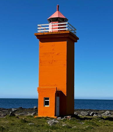
1925. Active; focal plane 14 m (46 ft); three flashes every 15 s, white or red depending on direction. 11 m (36 ft) square cylindrical concrete tower with lantern and gallery. Tower painted orange, lantern and gallery red. Tracy McQue's photo is at right, Wikimedia has Diego Delso's photo, Huelse has a photo, Trabas has Renate Riedel's photo, Myhre has a 2011 photo, Aðalsteinn Guðmundsson has a 2008 photo, Wikimedia has photos, and Google has a satellite view and a distant street view. Located at the west point of the Reykjanes peninsula, about 5 km (3 mi) south of Sandgerði. Parking available; there's an easy walk of about 300 m (0.2 mi) to the lighthouse. Site open, tower closed. . ARLHS ICE-025; VIT-003; Admiralty L4472; NGA 18180.

Stafnes Light, Suðurnesjabær, August 2019
Instagram photo by Tracy McQue

* Sandgerði
1916. Active; focal plane 25 m (82 ft); white, red or green light, depending on direction, occulting once every 6 s. 19 m (62 ft) square cylindrical concrete tower with lantern and gallery, arising at the seaward end of a large warehouse-type building. Tower painted yellow-brown. The tower also carries a red, inverted-triangular daymark. Trabas has Wöhrn's photo, Huelse has a photo, Myhre has a 2011 photo, Ólafur Ólafsson has a 2008 photo, and Google has a street view and a satellite view. The tower was raised in height in 1945. It was formerly the rear light of an approach range; the front light was removed when the lighthouse became a leading light. Located on the waterfront of Sandgerði, a town near the northwest corner of the Reykjanes peninsula, about 6 km (4.5 mi) west of Keflavík. Site open, tower closed. . ARLHS ICE-021; VIT-005; Admiralty L4476; NGA 18184.
** Garðskagi (1)
1897. Inactive since 1944. 11 m (36 ft) square concrete tower with replica lantern and gallery, attached to a small 1-story concrete equipment room. The original lantern was removed. Lighthouse painted white with two narrow red horizontal bands. A photo is at right, Anke and Jens have a page for the lighthouse, Myhre has a 2011 photo, Wikimedia has photos, Enjoy Poon has a street view, and Google has a satellite view. The lighthouse was replaced by a taller tower (next entry). In recent years the old tower has been refurbished and put to use as a bird observation tower. The August 2019 photo by Aureliano de los Ríos seen at right shows the lighthouse recently restored and with the replica lantern installed. Located on Garðskagi (Cape Garð), the northwestern tip of the Reykjanes peninsula, about 8 km (5 mi) northwest of Keflavík. Parking provided. Site open, tower open but we have no information on the schedule. . ARLHS ICE-016.
* Garðskagi (2)
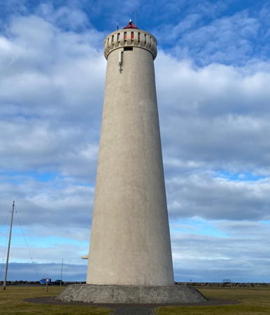
1944 (station established 1897). Active; focal plane 27 m (89 ft); white flash every 5 s; also a continuous passing light, white, red or green depending on direction, displayed at 10 m (33 ft). 27 m (89 ft) round concrete tower with lantern and gallery. Tower painted white, lantern red. Anke and Jens have a page with good photos, Trabas has Wöhrn's photo, Huelse has a photo, Myhre has a 2011 closeup, Ólafur Ólafsson has a 2008 photo, Wikimedia has photos, and Google has a street view and a satellite view. Located about 200 m (220 yd) southeast of the original lighthouse on Garðskagi (Cape Garð). Site open, tower closed. ARLHS ICE-015; VIT-009; Admiralty L4480; NGA 18196.

1897 Garðskagi Light, Suðurnesjabær, August 2019
Flickr Creative Commons photo by Aureliano de los Ríos


Keflavík Area (Reykjanesbær) Lighthouses
Keflavík (the name means "Driftwood Bay") is a fishing port at the northwest end of the Reykjanes Peninsula, southeast of Sandgerði. In 1995 it merged with surrounding communities to form a municipality called Reykjanesbær; the municipal population is about 20,000. The Keflavík International Airport is on the border between Suðurnesjabær and Reykjanesbær.
* Hólmsberg
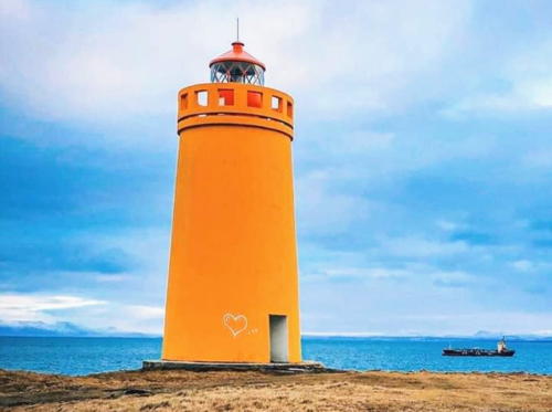
1956. Active; focal plane 36 m (118 ft); two flashes every 20 s, white, red or green, depending on direction. 13 m (43 ft) round concrete tower with lantern and gallery. Tower painted orange, lantern and gallery red. Mustafa Bilal's 2023 photo is at right, Anke and Jens have a page with a great photo, Trabas has Wöhrn's photo, Myhre has a 2011 photo, Roberto Berti has a 2021 photo, Huelse has a photo, Johan Lindqvist has a great 2007 photo, and Google has a satellite view. Located on a promontory about 2.5 km (1.5 mi) northwest of Keflavík. Site open, tower closed. . ARLHS ICE-047; VIT-015; Admiralty L4483; NGA 18216.
* Vatnsnes (Keflavík)
1922. Active; focal plane 12 m (39 ft); three flashes every 10 s, white or red depending on direction. 8 m (26 ft) square cylindrical concrete tower with lantern and gallery. Radek Literski visited in 2017 and found the lighthouse painted orange, as seen in Aslanbek Magamadov's 2022 photo. It was previously painted yellow, and Huelse's photo shows the tower painted white and the lantern and gallery blue. Trabas has Renate Riedel's photo, Myhre has a 2011 photo, and Google has a 2013 street view and a satellite view. Located in a warehouse area at the tip of the Vatnsnes peninsula, on the northwest side of Keflavík harbor. Site open, tower closed. . ARLHS ICE-094; VIT-016; Admiralty L4488; NGA 18212.
Gerðistangi
1918. Active; focal plane 11 m (36 ft); two flashes every 10 s, white, red or green, depending on direction. 10 m (33 ft) square cylindrical concrete tower with lantern and gallery. Tower painted orange, lantern and gallery red. Anke and Jens have a page with a good photo, Trabas has Wöhrn's photo, Myhre has a 2011 photo, Huelse has a closeup photo, and Google has a satellite view and a very distant street view. Located on a point of land near Vogar, about 12 km (7.5 mi) east of Keflavík. The lighthouse is about 600 m (0.4 mi) from the nearest road and the surrounding land is probably private. Site and tower closed. ARLHS ICE-038; VIT-019; Admiralty L4494; NGA 18236.

Hólmsberg Light, Reykjanesbær, September 2023
Google Maps photo by Mustafa Bilal

Höfuðborgarsæði (Capital) Region (Reykjavík Metropolitan Area) Lighthouses

Reykjavík is the capital and largest city of Iceland; the city has a population of about 140,000 and the capital region has a total population of about 250,000. The city faces the open bay of the Faxaflói and is Iceland's largest port.

Reykjavík Approach Lighthouses
Straumsvík Range Rear
Date unknown. Active; focal plane 14 m (46 ft); green light occulting once every 3 s. 7 m (23 ft) post carrying a red triangular daymark and centered on a square white concrete equipment shelter. Trabas has Capt. Peter's photo and Google has a street view and a satellite view. The front light is on a post. Located on the waterfront of an industrial harbor at Straumsvík. Site open, tower closed. VIT-020.1; Admiralty L4495.1; NGA 18256.
* Hafnarfjörður (Straumsvík Leading Light)
Date unknown. Active; focal plane 13 m (43 ft); flashing directional light, white, red or green depending on direction. 6 m (20 ft round concrete tower rising at the seaward end of a 1-story concrete building. Trabas has Capt. Peter's closeup photo and Google has a street view and a satellite view. This light replaced the former Hafnarfjörður range lights (see next entry). Located on the waterfront on the north side of Hafnarfjörður harbor, a fishing port on the southwest side of Reykjavík. Site open, tower closed. VIT-022; Admiralty L4498.5; NGA 18259.
* Hafnarfjörður Range Rear (1)
1901. Inactive. Approx. 6 m (20 ft) square cylindrical tower; the light was shown through a square window at the top of the tower. Lighthouse painted with red and white horizontal bands. A closeup photo is available, Huelse has a photo, and Google has a distant street view and an indistinct satellite view. All the photos show that the lighthouse is being maintained in good condition. The front light of the former range may have been on the same location as the present directional light (previous entry). Located on a hill off Vitastígur street in Hafnarfjörður. Site open, tower closed. ARLHS ICE-112.
* Álftanes
Date unknown. Active; focal plane 5 m (17 ft); white, red or green depending on direction, occulting once every 3 s. 4 m (13 ft) square concrete tower painted orange with a red vertical stripe. Trabas has Wöhrn's photo, a 2021 photo is available, Mustafa Bilal has a 2024 photo, and Google has a street view and a satellite view. This leading light guides smaller vessels toward the Karnes neighborhood in southern Reykjavík. Located in a residential neighborhood off the Jörfavegur. Site open, tower closed. VIT-025; Admiralty L4499; NGA 18268.
* Grótta
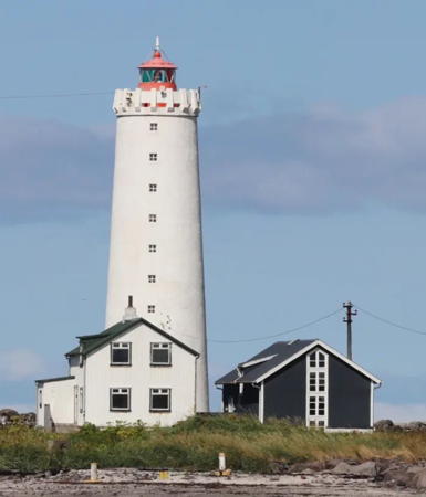
1897. Active; focal plane 24 m (79 ft); three flashes every 20 s, white, red or green depending on direction. 23 m (75 ft) concrete tower with lantern and gallery. Tower painted white, lantern red. Jørgen Akselvoll's 2023 photo at right shows the two relatively modern keeper's houses, Anke and Jens have a page with good photos, Myhre has a 2011 photo, Trabas has Wöhrn's photo, Kjartan and Inga Dögg have a nice 2009 photo, a distant view is available, Wikimedia has photos, and Google has a distant street view and a good satellite view. Grótta is an island off the end of the Seltjarnarnes peninsula about 15 km (9 mi) west of downtown Reykjavík. The lighthouse marks the entrance to the city's harbor. Parking is provided on the cape, and with some care it is possible to walk to the island at low tide. The lighthouse is also a popular spot for viewing auroras ("northern lights"). Site open, tower closed. . ARLHS ICE-044; VIT-028; Admiralty L4501; NGA 18292.

Grótta Light, Reykjavík, August 2023
Instagram photo by Jørgen Akselvoll

Reykjavík City Lighthouses
Engey
1937. Active; focal plane 11 m (36 ft); flash every 5 s, white, red or green depending on direction. 8 m (26 ft) square stone tower with lantern and gallery. Entire lighthouse painted yellow. Trabas has Hartmann's photo, a 2015 photo is available, Myhre has a very distant view, and Google has a satellite view. This is the approach leading light for Reykjavík. Engey is an island on the east side of Reykjavík's commercial harbor. Located on the northwestern tip of the island. Accessible only by boat. Site status unknown; there is a view from ships entering the harbor. ARLHS ICE-035; VIT-031; Admiralty L4505; NGA 18300.
Reykjavík Norðurgarði (North Mole Head)
Date unknown. Active; focal plane 7 m (23 ft); green flash every 2 s. 4 m (13 ft) square corrugated iron tower with lantern and gallery, painted yellow. Trabas has Hartmann's closeup photo, Mustafa Bilal has a 2024 photo, Myhre has a 2011 photo, this is the more distant light in Huelse's photo, Luke Godward has a street view along the pier, and Google has a satellite view. Located at the end of the north breakwater of the main harbor of Reykjavík, on the west side of the city. Probably accessible only by boat. Site open, tower closed. VIT-034; Admiralty L4506; NGA 18316.
* Reykjavík Ingólfsgarði (South Mole Elbow)
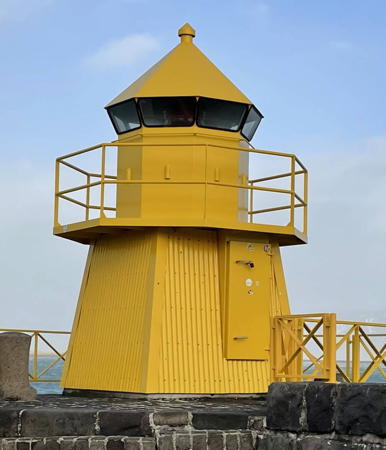
Date unknown. Active; focal plane 7 m (23 ft); red flash every 2 s. 4 m (13 ft) square corrugated iron tower with lantern and gallery, painted yellow. Rui Sarmento's 2023 photo is at right, this is the closer light in Huelse's photo,Trabas has Hartmann's closeup photo, a 2021 photo is available, Myhre has a 2011 closeup, Markús Auðunn Viðarsson has a street view, and Google has a satellite view. Located at the elbow of the south breakwater of the main harbor of Reykjavík, on the west side of the city. Accessible by walking the mole. Site open, tower closed. VIT-033; Admiralty L4508; NGA 18320.
* Reykjavík (Sjomannaskolinn, Seaman's School) (2)
1945 (station established 1897). Inactive since 2019. 32 m (105 ft) square cylindrical masonry tower, topped by an octagonal tower with a gallery and a tall steeple, and attached to the front of a large 4-story academic building. Building painted gray. Huelse has a photo, Trabas has Hartmann's photo, and Google has a street view and a satellite view. The Seaman's School was established in 1891 but the present building was built in 1944-45. It is now known as the Tækniskólinn (Technical School); it offers a dozen technical curricula including Navigation and Marine Engineering. By 2017 construction of new buildings had partially obscured the light and it was announced that the light would be moved to a new lighthouse to be built on the waterfront (next entry). Located on a hill overlooking Reykjavík harbor. Site open, tower status unknown. ARLHS ICE-076; ex-VIT-030; ex-Admiralty L4503; NGA 18308.

Ingólfsgarði (South Mole) Light, Reykjavík, February 2023
Google Maps photo by Rui Sarmento
* Sæbraut (Höfði)
2019. Active; focal plane about 12 m (39 ft); white, red or green light depending on direction, 2 s on, 2 s off. Approx. 4 m (13 ft) square corrugated iron tower with lantern and gallery, painted yellow. This is the new light replacing the Sjomannaskolinn light. Trabas has a closeup photo, Manfred Pletschacher has a good photo, William Kan has a 2024 photo, Gerben Drijfhout has a midsummer sunset photo, and Google has a satellite view. This is the entrance leading light for the harbor. The new lighthouse was in place by April 2019 and was activated in June. Sæbraut is its official name but everyone seems to be calling it the Höfði lighthouse. Located on Sæbraut coastal boulevard opposite the historic Höfði House. Site open, tower closed. . VIT-30.1; Admiralty L4502.
Skarfagarðs (Skarfagarth)
Date unknown. Active; focal plane 8 m (26 ft); green flash every 2 s. 4 m (13 ft) square tower with lantern and gallery. Entire lighthouse painted yellow. Trabas has Hartmann's photo, Ron Zoeteweij has a closeup photo, Sergio Agrò has a 2022 photo, G. Hine has a closeup street view, and Google has a satellite view. Located at the end of the Skarfagarðs jetty, which shelters the Viðey ferry terminal in downtown Reykjavik. Accessible by walking the mole. Site open, tower closed. . VIT-036; Admiralty L4513.3; NGA 18341.

Kjósarhreppur Lighthouse
[Hvaleyri (Kjósarhreppur)]
Date unknown. Active; focal plane 6 m (20 ft); flash every 5 s, white, red or green depending on direction. 3 m (10 ft) octagonal cast iron lantern painted yellow (formerly red). Sigurdur Fjalar Jonsson has a 2023 photo, Marinetraffic.com has photos by Magnus Thor Hafsteinsson and Google has a distant satellite view. Located on a sharp promontory projecting into the south side of the Hvalfjörður. Site open, tower closed. ICE-120; VIT-047; Admiralty L4516; NGA 18364.

Vesturland (Central West Coast) Lighthouses

Vesturland is the west coast region north of Reykjavík and south of the northwest fjords regions. A major feature of this region is the Snæfellsnes peninsula, a long finger of volcanic land separating two bays, the Faxaflói on the south and the Breidafjörður on the north. The peninsula is famous for the Snæfellsjökull volcano and glacier and in 2001 much of it was set aside as a national park. The volcano is not considered to be extinct but its last eruption was about 1800 years ago.

Akranes Area Lighthouses
Akranes is a town on the north side of the Faxaflói, the bay of Reykjavík, separated from Reykjavík by the Hvalfjörður (Fjord of Whales). Since 1998 a tunnel under the fjord has provided a quick route to the town, bringing Akranes into the Reykjavík metropolitan area. The town has a population of about 8000.
* Krossvík Fremra (Range Front)
Date unknown. Active; focal plane 10 m (33 ft); white, red or green light depending on direction, occulting once every 5 s. 6 m (20 ft) lantern and gallery mounted atop a square concrete equipment shelter. A red triangular daymark is displayed on a post mounted on the gallery. Entire lighthouse painted yellow or orange. Huelse has a good photo, a closeup is available, a 2018 photo shows the tower painted orange, and Google has a street view and a satellite view. In 2018 the front range light was replaced with a directional light and the rear light was discontinued. The light leads vessels on the approach to Akranes. The former rear light was on a radio transmission tower. Located on the waterfront on the east side of Akranes, adjacent to an athletic field. Site open, tower closed. . VIT-049.2; Admiralty L4518; NGA 18368.
* Akranes Directional (Range Rear)
Date unknown. Active; focal plane 40 m (131 ft); white, red or green light depending on direction, occulting once every 3 s. 28 m (95 ft) square skeletal communications tower painted black. Google has a street view and the light is centered in Google's indistinct satellite view. In 2018 the rear range light was replaced with a directional light and the front light was discontinued. The light leads vessels on the entrance to Akranes harbor. Located on the Kirkjubraut in downtown Akranes. Site open, tower closed. VIT-052.1; Admiralty L4522.1; NGA 18388.
** Akranes (1)
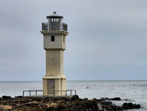
1918. Inactive since 1947. Approx. 13 m (43 ft) square dumbbell-shaped concrete tower with lantern and gallery. Lighthouse painted white, lantern gray. Anke and Jens have a page with good photos, Piotr Somerfeld has a great photo, Julius Matikas has a 2021 photo, Huelse also has a good photo, a photo showing both lighthouses is available, and Google has a satellite view. Google's street view shows the lighthouse being repainted in August 2013. Located at the extreme tip of the Skipaskagi (Ships' Cape) peninsula, the lighthouse appears to be endangered by erosion. Parking provided. Site open, tower open but we have no information on the schedule. ARLHS ICE-003.
* Akranes (2)
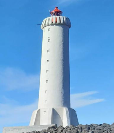
1947 (station established 1918). Active; focal plane 24 m (79 ft); two flashes every 20 s, white, red or green depending on direction. 21 m (69 ft) concrete tower with lantern, gallery, and eight buttresses at the base. Tower painted white, lantern red. A 2022 photo is at right, Trabas has Wöhrn's photo, another photo is available, Anke and Jens have a good page for the station, Huelse also has a good photo, and Google has a street view and a satellite view. Located a short distance north of the original lighthouse. Parking provided. Site open, tower closed. . ARLHS ICE-002; VIT-050; Admiralty L4520; NGA 18372.
* Bióhöllin (Lambhusasand Range No. 1 Rear)
Date unknown. Active; focal plane about 20 m (66 ft); continuous red light. Post carrying a triangular daymark mounted on the roof of the Bióhöllin movie theater. Google has a street view and a satellite view. This is the approach range for the western harbor basin. Built in 1942, the theater is a landmark building in Akranes. Site open. VIT-054.2; Admiralty L4523.1; NGA 18389.1.


1947 Akranes Light, Akranes, May 2022
Google Maps photo by Leo

Rauðanes
1940. Active; focal plane 8 m (26 ft); flash every 5 s, white, red or green depending on direction. 4 m (13 ft) hexagonal concrete equipment room; the light is shown through a window. Lighthouse painted yellow. Bjorn Þorvaldsson has a closeup photo, a distant view is available, and Google has a satellite view. Located on a sharp promontory on the north side of the Faxaflói about 2.5 km (1.5 mi) southwest of Bogarnes. Probably accessible only by boat. Site open, tower closed. VIT-057; Admiralty L4529; NGA 18408.
Þormóðssker (Thormodhssker)
1947. Active; focal plane 35 m (115 ft); one long flash every 20 s, white, red or green depending on direction. 23 m (75 ft) square cylindrical concrete tower with lantern and gallery. The tower is unpainted concrete with black panels giving the appearance of a black vertical stripe on each face; lantern painted black. A photo is available, Þórdís Björnsdóttir has a 2010 closeup photo, Fridrik Helgi has a 2018 photo, and Google has a satellite view. Located on Thormodh's Skerry, a small rocky island in the Faxaflói about 13 km (8 mi) northwest of Akranes. Accessible only by boat. Site and tower closed. ARLHS ICE-101; VIT-055; Admiralty L4526; NGA 18392.

Snæfellsnes South Shore Lighthouses
* Kirkjuhóll
1953. Active; focal plane 36 m (118 ft); one long (2 s) flash every 10 s, white, red or green depending on direction. 6 m (20 ft) semi-elliptical concrete tower with lantern. The lighthouse is unpainted white concrete. Trabas has Eckhard Meyer's photo, Huelse has a photo, Laxic Hsiao has a photo, Ólafur Ólafsson has a distant view, and Google has a street view and a satellite view. Located off highway 54 midway on the south shore of the Snæfells peninsula. It's a walk of about 400 m (1/4 mi) to the lighthouse. Site open, tower closed. ARLHS ICE-062; VIT-058; Admiralty L4531; NGA 18416.
* Arnarstapi
Date unknown. Active; focal plane 18 m (59 ft); one long flash every 5 s, white, red or green depending on direction. 3 m (10 ft) rectangular white concrete building; the light is shown through a window. Trabas has Eckhard Meyer's photo, a 2022 photo is available, and Google has a satellite view. Located on a headland on the south side of Arnarstapi, a small harbor on the southwest coast of the Snæfells peninsula. Site open, tower closed. ARLHS ICE-116; VIT-059; Admiralty L4532; NGA 18420.
* Malarrif (2)
1946 (station established 1917). Active; focal plane 30 m (98 ft); four flashes every 30 s, white, red or green depending on direction. 24 m (79 ft) round cylindrical concrete tower with four buttresses, lantern and gallery. Lighthouse painted white, lantern red. Zuzka Krajčová's 2023 photo is at right, Trabas has Wöhrn's photo, Huelse has a photo, Vlad Bogdan has a 2017 photo,Paul Bradshaw has a 2019 street view, and Google has a satellite view and very distant street view. Located on the south coast of the Snæfells peninsula about 15 km (9 mi) southwest of Gröf. Accessible by road. Site open, tower closed. . ARLHS ICE-067; VIT-062; Admiralty L4534; NGA 18412.

Malarrif Light, Snæfellsnes, March 2023
Google Maps photo by Zuzka Krajčová

Snæfellsnes West End Lighthouses
* Svörtuloft (2)
1931 (station established 1914). Active; focal plane 30 m (98 ft); two white flashes every 10 s. 12 m (39 ft) square cylindrical concrete tower with lantern and gallery. Tower painted yellow, lantern red. Trabas has Wöhrn's closeup photo, a 2017 photo is available, Algo Trendy has a 2021 photo, Huelse has a photo, Google has a street view, and Bing has a satellite view. This lighthouse and the next one mark the blunt western end of the Snæfells Peninsula. Located about 8 km (5 mi) southwest of Hellissandur. Site open, tower closed. ARLHS ICE-091; VIT-063; Admiralty L4538; NGA 18424.
* Öndverðarnes
1973. Active; focal plane 11 m (36 ft); white flash every 3 s. 4 m (13 ft) octagonal cast iron lantern centered on a small 1-story square concrete equipment room. Equipment room painted yellow, lantern red. Josef Schmid's 2023 photo is at right, Trabas has Renate Riedel's photo, Huelse has a photo, Zsófia Balatoni has a winter sunset photo, Daniel Makrinos has a 2022 street view, and Google has a satellite view. Located on the extreme northwestern tip of the Snæfells Peninsula, about 2.5 km (1.5 mi) north of the Svörtuloft lighthouse. Site open, tower closed. . ARLHS ICE-099; VIT-064; Admiralty L4540; NGA 18428.

Snæfellsnes North Shore Lighthouses
Taska (Rif)
Date unknown. Active; focal plane 13 m (43 ft); green flash every 3 s. 13 m (43 ft) round lantern and gallery perched on a slender iron pole. Lantern painted green. Huelse has a photo, Google has a distant street view, and Bing has an indistinct satellite view. Located in the Breidafjörður off the village of Rif, about 6 km (3.5 mi) east of Hellissandur. Accessible only by boat, although there may be a good view from shore. Site open, tower closed. VIT-066; Admiralty L4541.8; NGA 18432.

Öndverðarnes Light, Hellissandur, December 2023
Instagram photo by Josef Schmid
* Ólafsvík
Date unknown. Active; focal plane 15 m (49 ft); flash every 5 s, white, red or green depending on direction. 3 m (10 ft) rectangular concrete building painted orange; the light is shown through a window. Trabas has Wöhrn's photo, Björn Ólafsson has a 2023 closeup, Google has a street view, and Google has a satellite view. Located on a headland on the south side of Arnarstapi, a small harbor on the southwest coast of the Snæfells peninsula. Site open, tower closed. ARLHS ICE-098; VIT-071; Admiralty L4542; NGA 18452.
Krossnes
1926. Active; focal plane 19 m (62 ft); four flashes every 20 s, white, red or green depending on direction. 9 m (30 ft) square cylindrical concrete tower with lantern and gallery, painted yellow. Trabas has Wöhrn's photo, Huelse has a photo, Martin Nouza also has a photo, and Google has a distant satellite view. Located at the end of a promontory 8 km (5 mi) northwest of Grundarfjörður. It appears from Huelse's photo that the lighthouse is on a farm. Site and tower closed. ARLHS ICE-065; VIT-074; Admiralty L4544; NGA 18464.
Höskuldsey (2)
1948 (station established 1926). Active; focal plane 16 m (52 ft); flash every 6 s, white, red or green depending on direction. 10 m (33 ft) square cylindrical concrete tower with lantern and gallery, painted yellow. Ingvar Hreinsson has a closeup photo and Google has a good satellite view. Höskuldsey is a small island in the Breidafjörður about 15 km (9 mi) west of Stykkishölmur. Located on the highest point of the island. Accessible only by boat. Site open, tower closed. ARLHS ICE-009; VIT-077; Admiralty L4550; NGA 18476.
* Súgandisey
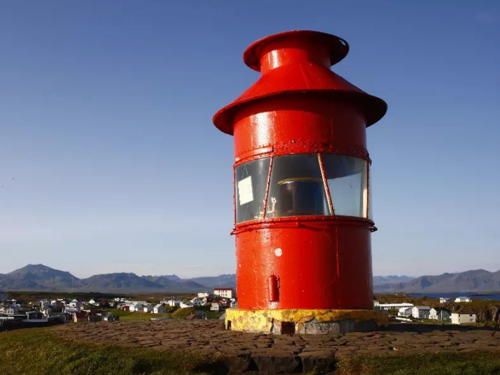
1948. Active; focal plane unknown; continuous red light. 4 m (13 ft) round lantern, painted red. Dario Colombo's 2022 photo is at right, Tricia Roth has a closeup photo, Trabas has Eckhard Meyer's closeup, Henry Oude Egberink has a photo, Peter Neumüller has a good street view, and Google has a satellite view. Located on a hilltop on the north side of the harbor of Stykkisholmúr. Site open, tower closed. . ARLHS ICE-114; VIT-080; Admiralty L4554; NGA 18484.
Elliðaey
1951. Active; focal plane 47 m (154 ft); flash every 10 s, white, red or green depending on direction. 9 m (30 ft) triangular cylindrical concrete tower with lantern and gallery, painted white; lantern painted red. Ingvar Hreinsson has a closeup photo and a second photo, Huelse has a distant photo, Kirill Sergeev has a view from the sea, and Google has a satellite view. Elliðaey is a small island in the Breidafjörður about 5 km (3 mi) northwest of Stykkishölmur. Located on the highest point of the island, which is at the east end. Accessible only by boat; there are views from the ferry crossing the Breidafjörður from Stykkishölmur to Flatey and Brjánslaekur. Site status unknown. ARLHS ICE-004; VIT-078; Admiralty L4552; NGA 18480.

Súgandisey Light, Stykkisholmúr, April 2022
Instagram photo by Dario Colombo

Information available on lost lighthouses:

Notable faux lighthouses:

Adjoining pages: North: Northern Iceland | East: East and South Iceland

Return to the Lighthouse Directory index | Ratings key

Posted September 11, 2006. Checked and revised March 29. 2024. Lighthouses: 41. Site copyright 2024 Russ Rowlett and the University of North Carolina at Chapel Hill.