Lighthouses of Israel

The State of Israel (Medīnat Yīsrāʾēl in Hebrew) is on the southeastern shore of the Mediterranean Sea with a territory that also touches the north end of the Gulf of Aqaba, an extension of the Red Sea.

Like most of the Middle East the territory of Israel was part of the Ottoman (Turkish) Empire for four centuries until World War I. The area was occupied by British troops in 1917 and after the end of World War I it became part of the British Mandate of Palestine. The state of Israel proclaimed its independence in 1948 when British forces were withdrawn. Since then Israel has fought several wars with its Arab neighbors, and after the conclusion of the Six Day War in 1963 Israel assumed effective control over the former territory of the mandate. Israeli forces withdrew from Gaza in 2005, but otherwise the Mediterranean coastline of the former mandate has remained under Isreali sovereignty throughout the varioußs conflicts.

Israel has a coastline about 273 km (170 mi) long facing west on the Mediterranean Sea. In addition, at its southern tip the country has a very short coastline on the Gulf of Aqaba, an arm of the Red Sea. The most important ports are Haifa and Ashdod on the Mediterranean and Eilat on the Gulf of Aqaba.

Israel is divided into seven administrative districts (mehozot, sing. mehoz), including one for the occupied West Bank.

Lighthouses in Israel are operated by the Administration of Shipping and Ports, an agency of the Ministry of Transport and Road Safety. There are historic light stations at Yafo (Jaffa), Tel Aviv, Har Karmel (Mount Carmel) and Akko (Acre).

Hebrew is the official language of Israel. The Hebrew word for a lighthouse is מגדלור (mig'dalor).

ARLHS numbers are from the ARLHS World List of Lights. Admiralty numbers are from volume N of the Admiralty List of Lights & Fog Signals for the Mediterranean Sea. Lights of the Gulf of Aqaba were formerly included in volume E of the Admiralty List of Lights & Fog Signals but in 2013 they were moved to volume D with new numbers. U.S. NGA List numbers are from Publication 113 for the Mediterranean Sea and 112 for the Gulf of Aqaba.

General Sources
List of Lighthouses in Israel
Introduction and index to Wikipedia's articles on the lighthouses.
Israeli Lighthouses
Danny Dorfman's outstanding collection of photos on Flickr.com.
Online List of Lights - Mediterranean Sea - Israel and Red Sea - Israel
Photos by various photographers posted by Alexander Trabas. Many of the photos from Israel are by Andreas Köhler or Hartmut Knape.
World of Lighthouses - Israel
Photos by various photographers available from Lightphotos.net.
Lighthouses in Israel
Photos by various photographers available from Wikimedia.
Leuchttürme in Israel
Photos by Andreas Köhler, taken in 2010.
Leuchtürme Asiens auf historischen Postkarten
Historic postcard views posted by Klaus Huelse.
GPSNauticalCharts
Navigational chart for Israel.
Navionics Charts
Navigational chart for Israel.


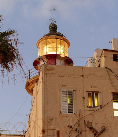
Har Carmel (Stella Maris) Light, Haifa, August 2017
Wikimedia Creative Commons photo by Sharon Leibel
South District: Eilat (Gulf of Aqaba) Lighthouses
* Eilat
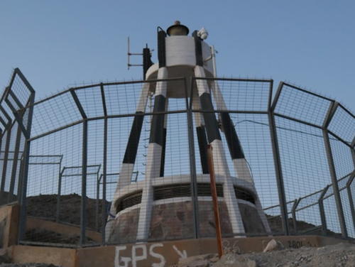
Date unknown. Active; focal plane 64 m (210 ft); white flash every 10 s. Approx. 9 m (30 ft) round 5-legged (pentapod) tower with lantern and gallery, rising from a round 1-story equipment shelter. Lighthouse painted white with black trim and a black band around each of the legs. A 2017 photo is at right, Trabas has Köhler's 2010 photo, Wikimedia has Dorfman's 2010 photo and several distant views, Google has a distant street view, and Bing has an indistinct satellite view. Located atop a steep bluff on the west side of the Gulf of Aqaba about 1.2 km (3/4 mi) northeast of the Egyptian border and 7 km (4.5 mi) southwest of the port of Eilat. Site open, tower closed. ARLHS ISR-002; Admiralty D7297.9 (ex-E6042); NGA 112-30436.

South District: Ashkelon and Ashdod Lighthouses
Ashkelon
1966. Active; focal plane 73 m (240 ft); two white flashes every 10 s. Approx. 20 m (66 ft) square skeletal tower. No photo available but Bing has a satellite view. Ashkelon, in southwestern Israel, is a city of about 150,000 residents. The site of a large power plant and a desalinization plant, it is also the Mediterranean terminal of the Trans-Israel oil pipeline. Located at the rear of the pipeline facility. Site and tower closed. Admiralty N5970; NGA 113-21272.
* Ashkelon (Ashqelon) Outer Breakwater
Date unknown. Active; focal plane unknown; two green flashes every 6 s. Approx. 18 m (56 ft) multistage unpainted concrete tower. No photo available but Google has an indistinct satellite view. Located at the end of the main breakwater at Ashkelon. Site and tower closed. Admiralty N5971; NGA 113-21272.2.
* Ashkelon (Ashqelon) Marina North Breakwater
Date unknown. Active; focal plane unknown; two green flashes every 5 s. Approx. 18 m (56 ft) multistage white tower mounted on a 2-story round concrete base. Wikimedia has several photos, Trabas has Köhler's photo, Lightphotos.net has a photo, and Google has a street view and an indistinct satellite view. Located at the end of the main breakwater of the Ashkelon Marina. Accessible by walking the pier. Site open, tower closed. Admiralty N5970.5; NGA 113-21272.1.

Eilat Light, Eilat, December 2017
Google Maps photo by Tomasz K
Ashdod Main Breakwater Head
Date unknown. Active; focal plane about 24 m (79 ft); green flash every 2 s. Approx. 20 m (66 ft) round concrete tower with gallery, painted with green and white horizontal bands. Trabas has Knape's photo and Bing has a satellite view. Located near the end of the extended main breakwater of the Ashdod port. Site and tower closed. Admiralty N5968.3.
Ashdod Main Breakwater Elbow
Date unknown. Active; focal plane about 16 m (52 ft); green light, pattern unknown. Approx. 12 m (39 ft) round concrete tower with two galleries, painted with green and white horizontal bands. Trabas has Knape's photo and Bing has a satellite view. Located at an elbow of the extended main breakwater of the Ashdod port. Site and tower closed. Admiralty N5968; NGA 113-21264.
Ashdod West Breakwater
Date unknown. Active; focal plane about 12 m (39 ft); green light, pattern unknown. Approx. 8 m (26 ft) square concrete tower; the front face is probably painted with green and white horizontal bands. Trabas has Knape's photo and Bing has a satellite view. Located at the former end of the main breakwater of the Ashdod port, now an elbow of the greatly extended pier. Site and tower closed. Admiralty N5969.1.
Ashdod Lee Breakwater
Date unknown. Active; focal plane about 10 m (33 ft); two quick red flashes every 2 s. Approx. 8 m (26 ft) square concrete tower; the front face is painted with red and white horizontal bands. Trabas has Knape's photo and Bing has a satellite view. Located on an inner breakwater of the Ashdod port. Site and tower closed. Admiralty N5969; NGA 113-21268.
Ashdod
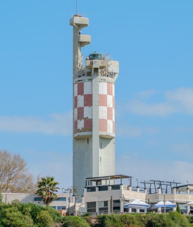
1966. Active; focal plane 76 m (249 ft); three white flashes every 20 s. 42 m (138 ft) cylindrical concrete tower carrying an array of communications gear as well as a lantern. The upper half of the lighthouse is round and is painted in a red and white checkerboard pattern; the lower half is triangular and is unpainted gray concrete. The lantern and lens were transferred from the Yafo (Jaffa) Light (next entry). A 2024 photo is at right, Trabas has Köhler's photo, Dorfman has three good photos, Wikimedia has a portfolio of photos, and Google has a street view and a fuzzy satellite view. Founded in 1956, Ashdod has a large modern harbor and has become Israel's largest port. The city has a population of about 225,000. Located on Yonah Hill on the south side of the harbor of Ashdod. Site and tower closed, but the lighthouse can be seen from many points in the area. ARLHS ISR-001; Admiralty N5967; NGA 113-21260.

Ashdod Light, Ashdod, March 2024
Wikimedia Creative Commons photo by Maqaf-Ivri

Tel Aviv District Lighthouses
Yafo (Jaffa) Breakwater (2)
Around 2018. Active; focal plane about 10 m (33 ft); green flash every 4 s. 6 m (20 ft) round concrete or fiberglass tower colored with green and white horizontal bands. Trabas has Eckhard Meyer's closeup photo Google has a 2020 street view from the city, and Bing has an indistinct satellite view. Sergej Kostjucenko has a 2016 street view of the earlier light, which appeared inactive at that time. Located at the end of the breakwater of Yafo's harbor. Accessible only by boat (the pier is not walkable). Site open, tower closed. Admiralty N5963; NGA 113-21256.
* Yafo (Jaffa) (3)
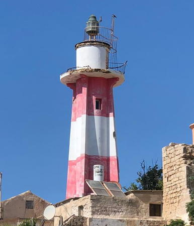
1936 (station established 1862). Deactivated officially in 1966 but probably reactivated unofficially; focal plane and light characteristic unknown. Approx. 10 m (33 ft) round cylindrical concrete tower with lantern, gallery, and four ribs. Lighthouse painted with red and white horizontal bands. The original lantern and lens were transferred to the Ashdod lighthouse in 1966. Dennis Jarvis's 2016 photo is at right, Dorfman has several photos, Wikimedia has a nice view of the lighthouse in context, David Gurevich has an evening street view from the breakwater, and Google has a street view but only a fuzzy satellite view of the neighborhood. The general-purpose Jaffa Light was deactivated in 1966 but the tower continued to be well maintained as a daybeacon. The fresh paint and solar panels seen in recent photos make it appear very likely that the light has been reactivated. Findlay's 1879 light list gives 1862 as the date of the first lighthouse. Huelse has a historic postcard view of the 1875 Jaffa lighthouse, which was built by French engineers for the Ottoman Empire. Jaffa (now called Yafo) is the historic port associated with Jerusalem. The ancient city is now a district within the much larger modern city of Tel Aviv, and in 1966 port operations were relocated to Ashdod. The old harbor now serves only small craft. Located on the historic Jaffa waterfront. Site open, tower closed. ARLHS ISR-005. Charted as disused by Navionics and not listed by the Admiralty. .
Yafo (Jaffa) Range Front
Date unknown. Active; focal plane about 16 m (52 ft); continuous red light. The light is on a slender mast atop a three-story waterfront building. Google has a street view but only a fuzzy satellite view. The range guides small craft through the very narrow opening between the end of the breakwater and Andromeda's Rock. Located on the historic Jaffa waterfront north of the lighthouse. Site open, tower closed. Admiralty N5962.4; NGA 21257.
Yafo (Jaffa) Range Rear
Date unknown. Active; focal plane unknown; continuous red light. The light is on a slender mast atop one of the old city's buildings. Google has a street view but only a fuzzy satellite view (the church seen in the street view is the Catholic church of St. Peter's, built in 1654). Located in the historic Old Jaffa neighborhood. Site open, tower closed. Admiralty N5962.5; NGA 21258.

Yafo (Jaffa) Light, Yafo, October 2006
Wikimedia Creative Commons photo by Dennis Jarvis
[Andromeda's Rock (2)]
Date unknown. Active; focal plane about 8 m (26 ft); quick-flashing yellow light. Approx. 7 m (23 ft) white mast standing on a square stone pier. Google has a 2017 street view and a fuzzy satellite view. NGA lists an "orange pillar." Located a short distance northeast of the Yafo Breakwater. Accessible only by boat but easy to see from the waterfront. Site open, tower closed. Admiralty N5964; NGA 21259.
* Tel Aviv Marina (2?)
Date unknown. Active; focal plane 10 m (33 ft); five green flashes every 20 s. 7 m (23 ft) round strongly conical concrete tower, painted green with two white horizontal bands. Wikimedia has numerous photos, Hadar Yarza has a 2022 photo, David Ichenhausen has a street view, and Google has a satellite view. NGA lists a "red pole, white bands." Located at the end of the main breakwater of the marina. Accessible by walking the pier. Site open, tower closed. Admiralty N5959.4; NGA 113-21252.
* Tel Aviv (Reading, Tel Kudadi, Hayarkon, Auja)
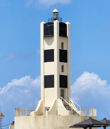
1935. Inactive since 1965 (a decorative light may be displayed); charted as disused by Navionics. Approx. 17 m (56 ft) square cylindrical concrete tower with a small lantern, mounted on a round stone foundation. Lighthouse painted white with four black panels mounted or painted on each face. Niv Baruch's 2023 photo is at right, Wikimedia has an excellent 2013 photo, Nadav Barkai has a 2016 photo, Google has a 2015 street view, and Bing an indistinct satellite view. Peggy Hadassah Mizrahi has a 2022 photo of the popular café at the base of the lighthouse. Built by British authorities, this lighthouse stands on the north side of the entrance to the HaYarkon (Yarkon) River in the area of Tel Kudadi, a stronghold from the Biblical period of Israel's history. The modern harbor of the Reading Power Plant is just to the north. The lighthouse was apparently restored sometime in 2011-12, and it may have been reactivated, although it has not been added to international light lists. The black panels on the tower recall the historic black and white checkerboard daymark pattern. The boardwalk seen in the recent photos was built in 2007 as part of a larger project to clean up the river and make it accessible to the public; it is also a part of the Israel National Trail. Located on the beach near the foot of the Tel Aviv South Breakwater. Site open, tower closed. . ex-Admiralty E5958.
* [Herzliya Marina (Main Breakwater)]
Date unknown. Active; focal plane 15 m (49 ft); green flash every 5 s. 11 m (36 ft) white concrete post with gallery. Wikimedia has David Shay's photo, Trabas has Köhler's photo of the two breakwater lights, and Google has a street view and an indistinct satellite view. Located at the end of the main breakwater of the marina at Herzliya, north of Yafo. Accessible by walking the pier. Site open, tower closed. Admiralty N5957; NGA 113-21238.
* [Herzliya Marina Lee Breakwater]
Date unknown. Active; focal plane 14 m (46 ft); red flash every 5 s. 11 m (36 ft) white concrete post with gallery. Trabas has Köhler's photo of the two breakwater lights, Gal Fridman has a drone view of both lights, and Google has a street view and an indistinct satellite view. Located at the end of the inner breakwater of the marina at Herzliya. Accessible by walking the pier. Site open, tower closed. Admiralty N5957.5.

Reading Light, Tel Aviv, May 2023
Wikimedia Creative Commons photo by Niv Baruch

Central District Lighthouse
* Mikhmoret (Michmoret)
Date unknown (1960s?). Active; focal plane 14 m (46 ft); two flashes, one white and one red, every 15 s. Light mounted on the roof of a 1-story concrete building supported by concrete piles. The building is painted dark blue with white trim. The building is part of the Mevo'ot Yam Nautical School. Dorfman has a closeup photo, Menachem Arslan has a street view, and Bing has a satellite view. Located on the north side of the harbor in Mikhmoret, about 7 km (4.5 mi) north of Netanya. ARLHS ISR-006; Admiralty N5956; NGA 113-21236.

Haifa District Lighthouses
Haifa is Israel's third largest city and second largest port with a population of about 300,000. The port area is on the southeastern side of Haifa Bay, the only naturally protected harbor on the Israeli coast.
* Har Carmel (Mount Carmel, Stella Maris) (5?)
1928 (station established 1864). Active; focal plane 179 m (587 ft); white flash every 5 s. 20 m (66 ft) octagonal cylindrical tower with lantern and gallery rising from the seaward end of a 3-story building. The building is painted a light buff color; the lantern is painted with red and white vertical stripes, but the dome is gray. This powerful light has a range of 55 km (35 mi). Sharon Leibel's photo is at the top of this page, Trabas has a photo by Capt. Peter Mosselberger, Wikimedia has numerous photos, Dorfman has a photo, Google has a very distant street view, and Bing has an indistinct satellite view. Mount Carmel is one of the most prominent landmarks along the Israeli coast, rising southeast of the seaport of Haifa. The lighthouse is often called the Stella Maris lighthouse because it is near the Carmelite Monastery of Stella Maris (Star of the Sea). Arne Berge has a view of the lighthouse and the monastery. The lighthouse building is in use by the Israeli military and is closed to the public. The earlier history of this light station is complex, and there is evidence of lights at several locations on the mountain at different times. Huelse has a postcard view of the 1864 lighthouse. The Fresnel lens of the lighthouse is on display (outdoors!) at the National Maritime Museum in Haifa. Located on the seaward face of Har (Mount) Carmel about 1.5 km (1 mi) east of Haifa. Site and tower closed, but the building can be viewed from nearby. ARLHS ISR-004; Admiralty N5945; NGA 113-21212.

Northern District Lighthouse
* Akko (Acre) (2)
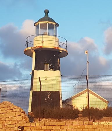
1912 (station established 1864). Active; focal plane 16 m (52 ft); two white flashes every 7 s. 10 m (33 ft) round cylindrical concrete tower with lantern, gallery, and four ribs. Lighthouse painted in a black and white checkerboard pattern; lantern dome is gray metallic. A small 1-story equipment building, painted white, stands next to the tower. Itzik Levy's 2020 photo is at right, Dorfman has a good 2009 photo, Trabas has a closeup photo, Wikimedia has numerous photos, Q.T. Luong has a photo of the seawall and light station, Google has a street view, and Bing has an indistinct satellite view. This is the only Israeli lighthouse surviving from the Ottoman era. The lighthouse is built atop the city's ancient walls on the site of an Ottoman watch tower. The ancient city of Acre, now called Akko, is built at the north entrance to the Haifa Bay, on a hook-shaped peninsula that shelters a small harbor. The lighthouse is located on the seaward face of the peninsula. Site open (the lighthouse is fenced but can be viewed from outside the fence.) Tower closed. . ARLHS ISR-003; Admiralty N5944; NGA 113-21204.


Akko (Acre) Light, Akko, June 2020
Google Maps photo by Itzik Levy

Information available on lost lighthouses:

Notable faux lighthouses:

Adjoining pages: North: Lebanon | East: Jordan | South: Egypt South Sinai and Suez | West: Gaza

Return to the Lighthouse Directory index | Ratings key

Posted June 4, 2007. Checked and revised May 7, 2024. Lighthouses: 18. Site copyright 2024 Russ Rowlett and the University of North Carolina at Chapel Hill.