Lighthouses of Japan: Northwestern Hokkaidō

The nation of Japan, known in Japanese as Nihon or Nippon (日本), occupies an archipelago off the east coast of Asia. The four main islands are Hokkaidō in the north, Honshū (the largest) in the center, Shikoku in the south, and Kyūshū in the southwest. The country includes thousands of other islands of all sizes; among them the Ryūkyū (Nansei) Islands are a long chain extending to the southwest and including the large island of Okinawa, and the Nanpō Islands are another long chain extending south into the Pacific Ocean. Much of Japan is mountainous but the coastal regions are densely populated and urbanized; the country's population is about 126 million.

Hokkaidō is the northernmost of the four main islands of Japan. It is very roughly triangular in shape, facing northeast on the Sea of Okhotsk, southeast on the Pacific Ocean, and west on the Sea of Japan. It is separated from Honshū to the south by the Tsugaru Strait and from Russian Sakhalin to the north by the La Pérouse or Sōya Strait.

Japan is divided into 47 prefectures. The entire island of Hokkaidō forms a single prefecture, making it by far the largest of the 47. The prefecture is divided into nine administrative regions, called subprefectures in English. The subprefectures of Hokkaidō are similar in size to the prefectures in the other main islands.

This page covers lighthouses of the northwestern coast of Hokkaidō, facing the Sea of Japan and including the subprefectures of Ishikari and Rumoi. For the most part this is a scenic but sparsely populated coast. Most of the lighthouses are accessible but rarely visited.

In Japanese, the word for a lighthouse is tōdai or toudai (灯台). The words saki and misaki are for capes and headlands, hana ("nose") is a promontory, hantō is a peninsula, shima (also spelled sima or jima) is an island, bae is a reef, iwa or shi is a rocky reef, amase or se is a shoal, wan is a bay, nada is a sound or basin, kaikyō is a strait, kawa is a river, and or minato is a harbor. In the Ainu language indigenous to this area, shir or shiri is an island.

Lighthouses in Japan are operated and maintained by the Japanese Coast Guard's Maritime Safety Agency. The lighthouses of Ishikari Subprefecture are the responsibility of the Coast Guard's Otaru Office and those of Rumoi Subprefecture are maintained by the Rumoi Office.

A note on the Sea of Japan/East Sea controversy: The Directory takes no side in any international dispute; it makes use of the terminology, names, and spellings as they currently exist in each area covered. The sea between Japan and Korea is called the Sea of Japan on the pages for Japan and the East Sea on the pages for Korea.

ARLHS numbers are from the ARLHS World List of Lights. JCG numbers are the Japanese Coast Guard's light list numbers. Admiralty numbers are from volume M of the Admiralty List of Lights & Fog Signals. U.S. NGA List numbers are from Publication 112.

General Sources
Lighthouses in Japan - Hokkaidō
Photos and data for Hokkaidō lighthouses.
Lighthouse-Japan.com - Hokkaidō
Another site with excellent photos and text in Japanese.
Form of a Lighthouse - Hokkaidō West Coast
Another site with many photos of lighthouses in northern Japan, cited below as FOAL.
Lighthouse Visits
Another good source of lighthouse photos.
Misty's Japanese Lighthouse Tour - Hokkaidō
Photos and brief notes in English.
Lighthouses in Hokkaido Prefecture
Photos available from Wikimedia.
Online List of Lights - Japan
Photos by various photographers posted by Alexander Trabas. Photos for this area are by Jonathon Post (Selector Jonathon Photography, SJP).
Navionics Charts
Navigation chart information for Hokkaidō.

Rumoi Light
Rumoi Light, Rumoi, September 2008
Wikimedia Creative Commons photo by 100yen

Ishikari Subprefecture Lighthouses

Ishikari City Lighthouses
Although the Ishikari District has city status, the lighthouses in this group are located on the steeply mountainous east coast of Ishikari Bay, a very rural area.
* Atsuta (Atsuga) Kō
1955. Active; focal plane 13 m (43 ft); green flash every 3 s. 10 m (33 ft) round cylindrical concrete tower with lantern and gallery. Entire lighthouse is white. A photo is at right, Trabas has an SJP photo, FOAL's page has photos, a 2020 photo is available, and Google has a satellite view and a distant street view. Located at the end of the main (west) breakwater of Atsuga, a fishing port about 25 km (15 mi) north of Otaru. Accessible by walking the pier. Site open, tower closed. ARLHS JPN-847; JCG-0573; Admiralty M6975.5; NGA 1240.
* Hamamasu (Kawashimo) Kō West Breakwater
1944. Active; focal plane 12 m (39 ft); red flash every 3 s. 11 m (36 ft) round cylindrical concrete tower with lantern and gallery. Entire lighthouse is red. Trabas has an SJP photo, FOAL's page has photos, and Google has a street view and a satellite view. Located at the end of the west (really south) breakwater of Hamamasu, a fishing port about 5 km (3 mi) south of Cape Poro. Accessible by walking the pier. Site open, tower closed. ARLHS JPN-896; JCG-0572; Admiralty M6974.4; NGA 1244.
* Hamamasu (Kawashimo) Kō North Breakwater
1964. Active; focal plane 14 m (46 ft); continuous green light with a more intense flash every 6 s. 11 m (36 ft) round cylindrical concrete tower with lantern and gallery. Entire lighthouse is white. Trabas has an SJP photo, FOAL's page has photos, and Google has a distant street view and a satellite view. Located at the end of the north (main) breakwater of Hamamasu. Accessible by walking the pier. Site open, tower closed. ARLHS JPN-895; JCG-0571; Admiralty M6974; NGA 1248.

Atsuga Kō Light, Atsuga, June 2015
ex-Panoramio Creative Commons photo by t-konno
* Horo (Poro, Ishikari Wan)
1986. Active; focal plane 61 m (200 ft); white flash every 10 s. 25 m (82 ft) round cylindrical concrete tower with lantern and gallery, attached to a small 1-story equipment building. Lighthouse painted with red and white horizontal bands. Lighthouse-Japan.com's page has good photos, Trabas has an SJP photo, FOAL's page has photos, Misty's Tour has a good photo, the Coast Guard has a photo, a 2019 closeup is available, and Google has a satellite view. This lighthouse is easy to see from a distance but tricky to locate; it can be reached from a side street off highway 231. No parking is provided. Located atop a promontory near the northern entrance to Ishikari Wan, about 50 km (30 mi) southwest of Rumoi. Site open, tower closed. . ARLHS JPN-138; JCG-0570; Admiralty M6973.5; NGA 1252.

Rumoi Subprefecture Lighthouses

Mashike Town Lighthouses
Ofuyu (Ohuyu) Kō Detached Breakwater
2009 (relocated from the North Breakwater). Active; focal plane 11 m (36 ft); two red flashes every 5 s. 11 m (36 ft) round cylindrical concrete tower with lantern and gallery, painted red. Trabas has an SJP photo, and Google has a satellite view and a street view across the harbor. Lighthouse-Japan.com has 2008 photos of the lighthouse, which was then painted white and located on the north breakwater of the harbor. It has been replaced there by a much smaller lightbeacon. Located on a detached breakwater at the entrance to Ofuyu, a fishing port just north of Cape Ofuyu and about 25 km (15 mi) southwest of Mashike. Accessible only by boat. Site and tower closed. ARLHS JPN-939; JCG-0569; Admiralty M6972.6.
* Betsukari (Betukari) Kō
Date unknown. Active; focal plane 14 m (46 ft); red light, 2 s on, 2 s off. 11 m (36 ft) round cylindrical concrete tower with lantern and gallery, painted red. FOAL's page has photos, Trabas has an SJP photo, and Google has a street view and a satellite view. Located at the end of the main (west) breakwater of Betukari, about 4 km (2.5 mi) southwest of Mashike. Accessible by walking the pier. Site and tower closed. ARLHS JPN-849; JCG-0568.3; Admiralty M6972.4; NGA 1258.
* Mashike Kō
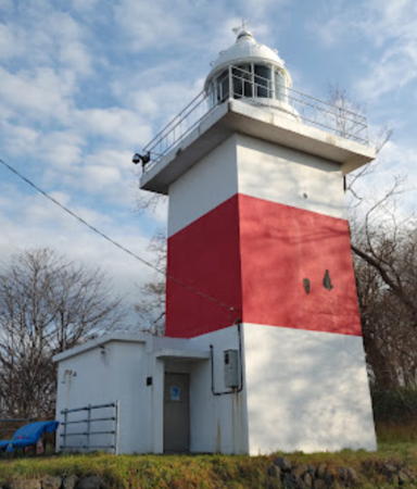
1890. Active; focal plane 46 m (151 ft); flash every 16 s, alternately red and white. 12 m (39 ft) square cylindrical concrete tower with lantern and gallery, attached to a small 1-story equipment building. Lighthouse painted white with one red horizontal band. Panda Keisei's 2022 photo is at right, a 2018 photo is available, Misty's Tour has a photo, FOAL's page has photos, Hiroshi Fukuyama has a closeup street view, and Google has a satellite view. Located on a bluff on the west side of the harbor of Mashike, about 16 km (10 mi) southwest of Rumoi. There is a driveway leading to the lighthouse but parking is limited. Site open, tower normally closed. . ARLHS JPN-332; JCG-0566; Admiralty M6970; NGA 1260.
* Mashike North Breakwater
1929. Active; focal plane 14 m (46 ft); red light, 3 s on, 3 s off. 12 m (39 ft) round cylindrical concrete tower with lantern and gallery, painted red. Trabas has an SJP photo, FOAL's page has photos, Matsumoto-pota Masa has closeup photo, and Google has a satellite view and a very distant street view. Located on the end of the short breakwater at the northwestern corner of Mashike harbor. Accessible by walking the pier. Site open, tower closed. ARLHS JPN-902; JCG-0567; Admiralty M6972; NGA 1268.
#Mashike West (Inner) Breakwater
1974. Inactive since 2020 and later demolished. This was an 11 m (36 ft) round hourglass-shaped concrete tower with lantern and gallery, painted red. FOAL's page has photos, Trabas has an SJP photo, Google has a distant 2014 street view, and Bing has a satellite view, but Google's satellite view confirms the removal. This light was deactivated in July 2020. Located on the end of the inner breakwater on the north side of Mashike harbor. Accessible by walking the pier. ex-JCG-0568; ex-Admiralty M6972.2; NGA 1256.

Mashike Kō Light, Mashike, November 2022
Google Maps photo by Panda Keisei

Rumoi City Lighthouses
The capital of the subprefecture, Rumoi is a fishing port with a population of about 25,000.
Rumoi South Breakwater (2)
1974 (station established 1932). Active; focal plane 16 m (52 ft); red flash every 3 s. 14 m (46 ft) round cylindrical concrete tower with lantern and gallery. Entire lighthouse is red. Trabas has an SJP photo, FOAL's page has photos, and Google has a satellite view and a very distant street view. The lantern and lens from the original light were transferred to the new tower when the breakwater was extended. Located at the end of the south breakwater of Rumoi. Site status unknown. ARLHS JPN-955; JCG-0562; Admiralty M6961; NGA 1276.
* [Hatō No Hito, Nami-tō No On'na]
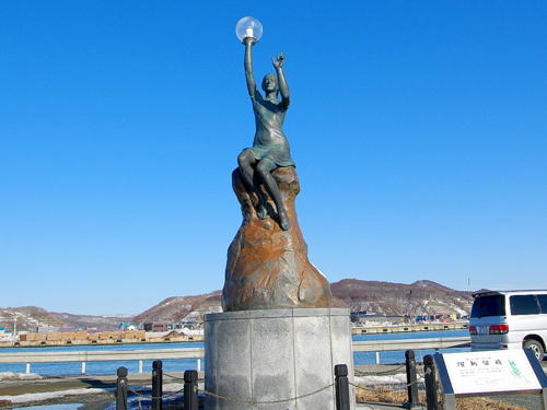
2007. Active (privately maintained); focal plane about 7 m (23 ft); white flash every 3 s. Approx. 5 m (17 ft) statue of a seated woman holding a light over her head. A Coast Guard photo is at right, Masayuki Ōkubo has a 2021 photo, Ki-Te Hysa has a photo, FOAL's page has photos, a 2022 photo is available, and Google has a satellite view. This statue, called "The Woman of the Wave Light (波灯の女)," was built with donations by the citizens of Rumoi. Located on the main quay at the south end of Rumoi harbor. Site open, tower closed. Owner/site manager: City of Rumoi. Charted as active by Navionics but not listed by the Admiralty.
Rumoi Inner Breakwater
1974 (station established 1932). Active; focal plane 12 m (39 ft); green flash every 3 s. 11 m (36 ft) round hourglass-shaped concrete tower with lantern and gallery, painted white. FOAL's page has photos, Trabas has an SJP photo, a 2023 photo is available, and Google has a satellite view. NGA calls this the north breakwater. Located at the end of an inner breakwater of Rumoi. Site status unknown. ARLHS JPN-954; JCG-0561; Admiralty M6962; NGA 1284.
Hatō No Hito Light
Hatō No Hito Light, Rumoi
Japanese Coast Guard Rumoi Office photo
Rumoi Southwest Breakwater (3)
2021. Active; focal plane 17 m (56 ft); two green flashes every 6 s. 16 m "white concrete column" according to the Admiralty announcement. This light replaced a lighthouse destroyed by a severe storm on 26 December 2017. Trabas has an SJP photo of the lost light, FOAL has a 2014 photo (sixth row left), and Google has a satellite view. The light is missing in Google's distant 2018 street view. A temporary light was announced in April 2018. We need a photo of the new light! Note: NGA calls this the west breakwater and continues to describe the former light. Located at the end of the west (outer) breakwater of Rumoi. Site status unknown. ARLHS JPN-956; JCG-0560; Admiralty M6960.8; NGA 1280.
* Rumoi
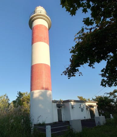
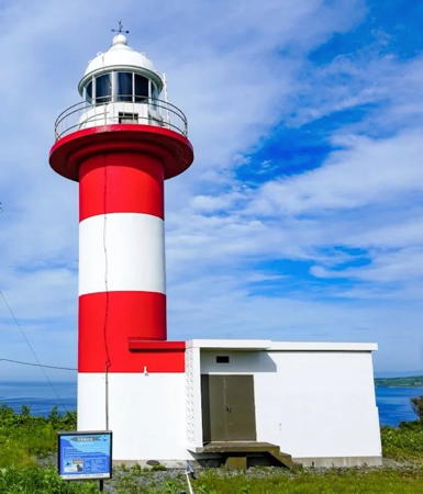
1966. Active; focal plane 58 m (190 ft); white flash every 8 s. 17 m (56 ft) round concrete tower with lantern and gallery, painted with red and white horizontal bands. A photo is at the top of this page, the Lighthouse-Japan.com page has photos, Trabas has an SJP photo, Hisanaga Harada has a 2021 photo, Misty's Tour has a closeup photo, FOAL's page has photos, and Google has a street view and a satellite view. Located on a hill behind (east) of the port of Rumoi. Accessible by walking the access road but parking is some distance away. Site open, tower closed. . ARLHS JPN-511; JCG-0558; Admiralty M6960.6; NGA 1272.

Tomamae Town Lighthouses
* Onishika
1950. Active; focal plane 13 m (43 ft); red flash every 10 s. 10 m (33 ft) round cylindrical concrete tower with lantern and gallery. Entire lighthouse is red. Trabas has an SJP photo, FOAL's page has photos and Google has a satellite view and a distant street view. Located at the end of the west (main) breakwater of Onishika, a small port about 25 km (15 mi) north of Rumoi. Accessible by walking the pier. Site open, tower closed. ARLHS JPN-942; JCG-0555; Admiralty M6958; NGA 1300.
* Rikibiru Kō
1967. Active; focal plane 11 m (36 ft); two red flashes every 8 s. 11 m (36 ft) round cylindrical concrete tower with lantern and gallery. Entire lighthouse is red. Trabas has an SJP photo, FOAL's page has photos, and Google has a street view and a satellite view. Located on a breakwater at the entrance to the harbor of Rikibiru about 6.5 km (4 mi) north of Onishika and 8 km (5 mi) south of Tomamae. Accessible by walking the pier. Site and tower closed. ARLHS JPN-953; JCG-0554; Admiralty M6957; NGA 1304.
Tomamae Saki
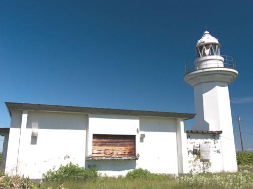
1958. Active; focal plane 68 m (223 ft); white flash every 5 s. 10 m (33 ft) concrete post light rising from a 1-story concrete equipment room. Entire lighthouse is white. Trabas has an SJP photo (also seen at right), Misty's Tour has a photo, FOAL's page has photos, a 2020 closeup is available, and Google has a street view and a satellite view. Located on a promontory just south of Tomamae. This lighthouse is difficult to locate without some local guidance. Site open, tower closed. . ARLHS JPN-667; JCG-0553; Admiralty M6955; NGA 1316.
* Tomamae Kō (North Breakwater)
1933. Active; focal plane 12 m (39 ft); red flash every 3 s. 11 m (36 ft) round cylindrical concrete tower with lantern and gallery. Entire lighthouse is red. Trabas has an SJP photo, FOAL's page has photos and Google has a satellite view. The breakwater was recently extended about 30 m (100 ft) and the lighthouse was relocated to the end of the extension. Located at the end of the north (main) breakwater of Tomomae. Accessible by walking the pier. Site and tower closed. JCG-0551; Admiralty M6954; NGA 1308.

Tomamae Saki Light, Tomamae
photo copyright Selector Jonathon Photography; used by permission

Haboro Town: Yagishiri Lighthouses
Yagishiri and Teuri are small islands in the Sea of Japan west of Haboro. Yagishiri, 20 km (13 mi) offshore, has a population of about 400 and is a nature preserve. Teuri is 28 km (17.5 mi) from Haboro and has a population of about 450. The two islands are administered as part of Haboro Town.

*
Yagishiri (Yakashiri)
1913. Active; focal plane 51 m (167 ft); four white flashes every 30 s; in addition, a continuous white spotlight (JCG-0543) illuminates the nearby reef Kamoi Iwa. 13 m (43 ft) octagonal cylindrical concrete tower with lantern and gallery, attached to a 1-story keeper's house. Lighthouse painted white. A Coast Guard photo is at right, the Lighthouse-Japan.com has a page with good photos, FOAL's page has photos, Toru Hei has a closeup photo, and Google has a street view and a satellite view. Located on the southeastern tip of the island. Site open, tower closed. . ARLHS JPN-744; JCG-0541; Admiralty M6944; NGA 1324.
* Nishiura (Nisiura) Breakwater
 Date unknown. Active; focal plane 10 m (33 ft); red flash every 3 s. 11 m (36 ft) round cylindrical concrete tower with lantern and gallery. Entire lighthouse is red. Google has a satellite view and a distant street view. Located at the end of the north (main) breakwater at Nishiura, a small port on the north coast of Yagashiri. Accessible by walking the pier. Site open, tower closed. ARLHS JPN-927; JCG-0542.5; Admiralty M6945; NGA 1330.
Yagishiri (Yakashiri) Breakwater
Date unknown. Active; focal plane 13 m (43 ft); two red flashes every 8 s. 11 m (36 ft) round cylindrical concrete tower with lantern and gallery, painted red. FOAL's page has good photos and Google has a satellite view and a distant street view. Located at the end of a detached breakwater at the entrance to Yagishiri harbor. Accessible only by boat. Site and tower closed. ARLHS JPN-1013; JCG-0542; Admiralty M6946; NGA 1328.
Yagashiri Light
Yagashiri Light, Haboro
Japanese Coast Guard Rumoi Office photo

Haboro Town: Teuri Lighthouses
* Teuri Tō
1968. Active; focal plane 76 m (249 ft); white flash every 10 s. 15 m (49 ft) round cylindrical concrete tower with lantern and gallery, attached to a small equipment room. Lighthouse painted with red and white horizontal bands. Yobito Kayanuma's 2011 photo is at right, Hiroyuki Watanabe has an excellent photo, FOAL's page has good photos, Katsumi Sakurai has a closeup street view, and Google has a satellite view and a very distant street view. Located on a bluff near the northern point of the island. Site open, tower closed. . ARLHS JPN-641; JCG-0548; Admiralty M6939; NGA 1336.
Gome Iwa
1963. Active; focal plane 11 m (36 ft); three quick white flashes every 10 s. 11 m (36 ft) round cylindrical concrete tower with lantern and gallery, painted black with a yellow horizontal band. FOAL's page has several photos and Google has a satellite view. Located on a reef off Gome Saki, the northern tip of Teuri To. Accessible only by boat. Site open, tower closed. JCG-0544; Admiralty M6942; NGA 1352.
Teuri Kō North Breakwater
1967. Active; focal plane 15 m (49 ft); red flash every 4 s. 11 m (36 ft) round cylindrical concrete tower with lantern and gallery, painted red. FOAL's page has photos and Google has a street view and a satellite view. Located at the end of the north breakwater of the small harbor of Teuri Tō. Site status unknown. ARLHS JPN-988; JCG-0545; Admiralty M6942.6; NGA 1344.
Teuri Kō South Breakwater
1973. Active; focal plane 11 m (36 ft); green flash every 4 s. 11 m (36 ft) round cylindrical concrete tower with lantern and gallery, painted white. FOAL's page has photos and Google has a street view and a satellite view. Located at the end of the south breakwater of the harbor of Teuri Tō. Site status unknown. ARLHS JPN-989; JCG-0547; Admiralty M6942.8; NGA 1348.
* Akaiwa Saki
1952. Active; focal plane 137 m (450 ft); two white flashes every 7 s. 9.5 m (31 ft) round concrete tower attached to a small equipment shelter. Entire lighthouse is white. A 2020 closeup photo is available, FOAL's page also has photos, and Google has a street view and a satellite view. A stairway descends from the lighthouse to an observation platform overlooking the Sea of Japan. Accessible by road; parking provided. Located at the southwestern tip of Teuri Tō. Site open, tower closed. . ARLHS JPN-843; JCG-0549; Admiralty M6941; NGA 1332.

Teuri Tō Light, Haboro, JUly 2016
Google Maps photo by Hiroyuki Watanabe

Haboro Town: Mainland Lighthouses
* Haboro Kō
1994. Active; focal plane 14 m (46 ft); red flash every 4 s. 11 m (36 ft) round cylindrical concrete tower with lantern and gallery. Entire lighthouse is red. FOAL's page has photos and Google has a satellite view. Located at the end of the west breakwater of Haboro, a port about 12 km (7.5 mi) northeast of Tomamae. Accessible by walking the pier. Site and tower closed. ARLHS JPN-858; JCG-0550; Admiralty M6950; NGA 1320.

Shosanbetsu Town Lighthouses
* Hatsuura Kō (Shosanbetsu)
1983. Active; focal plane 12 m (39 ft); two red flashes every 6 s. 10 m (33 ft) round cylindrical concrete tower with lantern and gallery. Entire lighthouse is red. FOAL's page has photos and Google has a satellite view and a distant street view. NGA lists this light as "Konpira Misaki South." Located at the end of the original south breakwater of Hatsuura harbor in Shosanbetsu, a port about 4 km (2.5 mi) south of Konpira Misaki. Accessible by walking the pier. Site and tower closed. JCG-0540.5; Admiralty M6934.5; NGA 1356.
* Konpira Misaki (Shosanbetsu)
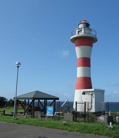
1969. Active; focal plane 55 m (180 ft); white flash every 4 s. 12 m (39 ft) hourglass-shaped concrete tower with lantern and gallery, colored with red and white horizontal bands. Yasutaka Ishizaki's 2019 photo is at right, Misty's Tour has a nice photo, Trabas has a good SJP photo, Takuya Takahashi has a street view, and Google has a satellite view. This lighthouse is built in a park (Misakidai Park) and there is an observatory close by. Located on a promontory on the north side of Shosanbetsu. Accessible by road, parking available. Site open, tower closed. . ARLHS JPN-287; JCG-0540; Admiralty M6935; NGA 1364.
#Toyosaki (Toyomisaki) Kō
Date unknown. Inactive since 2013 and later removed. This was a 10 m (33 ft) round hourglass-shaped concrete tower with lantern and gallery. Entire lighthouse was red. Google's satellite view and a distant view from shore show the lighthouse has been replaced by a small post light. Located at the end of the breakwater of Toyomisaki Kō, a small harbor on the north side of Konpira Misaki. Site and tower closed. ARLHS JPN-1003; ex-JCG-0539; ex-Admiralty M6936; ex-NGA 1360.

Konpira Misaki Light, Shosanbetsu, September 2019
Google Maps photo by Yasutaka Ishizaki

Information available on lost lighthouses:

Notable faux lighthouses:

Adjoining pages: East: Northern Hokkaidō | South: Southwestern Hokkaidō | West: Rishiri and Rebun

Return to the Lighthouse Directory index | Ratings key

Posted July 10, 2006. Checked and revised May 11, 2023. Lighthouses: 29. Site copyright 2023 Russ Rowlett and the University of North Carolina at Chapel Hill.