Lighthouses of Japan: Rishiri and Rebun, Hokkaidō

The nation of Japan, known in Japanese as Nihon or Nippon (日本), occupies an archipelago off the east coast of Asia. The four main islands are Hokkaidō in the north, Honshū (the largest) in the center, Shikoku in the south, and Kyūshū in the southwest. The country includes thousands of other islands of all sizes; among them the Ryūkyū (Nansei) Islands are a long chain extending to the southwest and including the large island of Okinawa, and the Nanpō Islands are another long chain extending south into the Pacific Ocean. Much of Japan is mountainous but the coastal regions are densely populated and urbanized; the country's population is about 126 million.

Japan is divided into 47 prefectures. Hokkaidō, northernmost of the four main islands, is governed as a single prefecture, making it by far the largest of the 47. The prefecture is divided into nine administrative regions, called subprefectures in English. The subprefectures of Hokkaidō are similar in size to the prefectures in the other main islands.

Rishiri and Rebun are volcanic islands in the Sea of Japan a few miles west of the northwestern coast of Hokkaidō.The two islands are very scenic and have become popular vacation destinations. Administratively they are governed as separate districts of the Sōya Subprefecture, which also includes the Wakkanai area of the mainland of Hokkaidō.

In Japanese, the word for a lighthouse is tōdai or toudai (灯台). The words saki and misaki are for capes and headlands, hana ("nose") is a promontory, hantō is a peninsula, shima (also spelled sima or jima) is an island, bae is a reef, iwa or shi is a rocky reef, amase or se is a shoal, wan is a bay, nada is a sound or basin, kaikyō is a strait, kawa is a river, and or minato is a harbor.

Lighthouses in Japan are operated and maintained by the Japanese Coast Guard's Maritime Safety Agency. Rishiri and Rebun lighthouses are the responsibility of the Wakkanai Coast Guard Office.

A note on the Sea of Japan/East Sea controversy: The Directory takes no side in any international dispute; it makes use of the terminology, names, and spellings as they currently exist in each area covered. The sea between Japan and Korea is called the Sea of Japan on the pages for Japan and the East Sea on the pages for Korea.

ARLHS numbers are from the ARLHS World List of Lights. JCG numbers are the Japanese Coast Guard's light list numbers. Admiralty numbers are from volume M of the Admiralty List of Lights & Fog Signals. U.S. NGA List numbers are from Publication 112.

General Sources
Lighthouses in Japan - Hokkaidō
This site covers nearly all of the major lighthouses in Japan.
Lighthouse-Japan.com - Hokkaidō
Another comprehensive site, with photos and accounts in Japanese.
Form of a Lighthouse - Hokkaidō West Coast
Another site with many photos of lighthouses in northern Japan; cited below as FOAL.
Online List of Lights - Japan
Photos by various photographers posted by Alexander Trabas.
Misty's Japanese Lighthouse Tour - Hokkaidō
Photos and brief notes in English.
Main Lighthouses of the Jurisdiction
Small photos of nine major lighthouses posted by the Wakkanai Coast Guard Office.
Navionics Charts
Navingational chart information for the islands.

Ishi Saki Light
Ishi Saki (Ishizaki) Light, Rishirifuji, October 2008
Flickr Creative Commons photo by shirokazan

Rishiri District Lighthouses

Rishiri is an island about 16 km (10 mi) off the northwestern tip of Hokkaidō. Formed by the extinct Mount Rishiri volcano, the island is roughly circular with a diameter of about 20 km (12.5 mi). Together with nearby Rebun it is part of the Rishiri-Rebun-Sarobetsu National Park. The island is a popular tourist destination accessible by air from Wakkanai or by ferry from Wakkanai or Otaru.

Rishirifuji Town Lighthouses
Motodomari (Hondomari) Kō North Breakwater
Date unknown. Active; focal plane 12 m (39 ft); green flash every 3 s. 11 m (36 ft) round barbell-shaped concrete tower with lantern and gallery. Entire lighthouse is white. FOAL's page has good photos, a winter photo is available, and Google has a satellite view and a distant street view. Located on the detached outer breakwater at Motodomari, on the northwestern coast of the island near the airport. Accessible only by boat. Site open, tower closed. ARLHS JPN-913; JCG-0527; Admiralty M6919; NGA 1420.
* Oshidomari (Peshi Misaki)
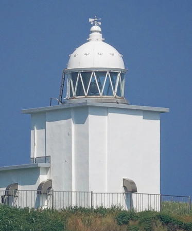
Date unknown (station established 1892). Active; focal plane 76 m (249 ft); white flash every 15 s. 10 m (33 ft) square cylindrical concrete tower with lantern and gallery, attached to a small equipment room. Entire lighthouse painted white. A 2022 closeup is at right, Lighthouse-Japan.com has a page with good photos, Misty's Tour has photos, FOAL's Oshidomari page has photos, a 2016 photo is available, Hiroki Ito has a street view, and Google has a satellite view. The photo at right and another photo show how the lighthouse is perched atop a steep cliff above the port of Oshidomari, the principal port of Rishiri. Accessible by a steep trail up the mountain. Site open, tower closed. . ARLHS JPN-494; JCG-0525; Admiralty M6915; NGA 1372.
Oshidomari Kō
Date unknown. Active; focal plane 15 m (49 ft); two red flashes every 6 s. 11 m (36 ft) round cylindrical concrete tower with lantern and gallery, painted red. A photo is at right, FOAL's Oshidomari page has photos, Takeshi Nishimura has a view from the sea, and Google has a satellite view and a sea view taken from an arriving ferry. Located at the end of the detached north outer breakwater at Oshidomari. ARLHS JPN-945; JCG-0526.1; Admiralty M6917; NGA 1378.
* Ishi Saki (Ishizaki)
1943. Active; focal plane 35 m (115 ft); flash every 20 s, alternately white and red. 32 m (105 ft) round concrete tower with lantern and gallery, attached to a small equipment room. Lighthouse painted with red and white horizontal bands. A photo is at the top of this page, Lighthouse-Japan.com has a page with excellent photos, FOAL's page has photos, Misty's Tour has two fine photos, a 2022 photo and a winter 2015 photo is available, and Google has a street view and a satellite view. This lighthouse is located at the eastern point of the island, marking the passage between Rishiri and the mainland of Hokkaidō. Accessible by road but there is no parking; a bike trail along the highway provides the best access. Site open, tower closed. . ARLHS JPN-178; JCG-0537; Admiralty M6928; NGA 1380.

Oshidomari Light, Rishirifuji, November 2022
Instagram photo by yukipon_nakano

Rishiri Town Lighthouses
* Senpōshi Saki
1971. Active; focal plane 29 m (85 ft); white flash every 5 s. 13 m (43 ft) round cylindrical concrete tower with lantern and gallery, attached to a small equipment room. Lighthouse painted with red and white horizontal bands. Lighthouse-Japan.com has a page for the lighthouse, FOAL has a page with good photos, Misty's Tour has additional photos, and Google has a street view and a satellite view. Located at the southern point of the island. Accessible by road; limited parking. Site open, tower closed. ARLHS JPN-551; JCG-0535; Admiralty M6927; NGA 1388.
* Senpōshi Kō South Breakwater
Date unknown (station established 1927). Active; focal plane 13 m (43 ft); red light, 3 s on, 3 s off. 11 m (36 ft) round cylindrical concrete tower with lantern and gallery, painted red. FOAL's Senpōshi page has photos, and Google has a street view and a satellite view. Located at the end of the south breakwater at Senpōshi Kō, about 3 km (1.8 mi) northwest of Senpōshi Saki. Site status unknown. ARLHS JPN-966; JCG-0534; Admiralty M6925; NGA 1396.
* Senpōshi Kō Outer Breakwater
Date unknown (station established 1927). Active; focal plane 13 m (43 ft); green light, 3 s on, 3 s off. 11 m (36 ft) round cylindrical concrete tower with lantern and gallery, painted white. FOAL's Senpōshi page has photos, a wintry photo shows Mount Rishiri to the north, and Google has a street view and a satellite view. NGA calls this the "east" breakwater light, which makes no sense. Located at the end of the detached west outer breakwater at Senpōshi Kō, about 3 km (1.8 mi) northwest of Senpōshi Saki. Site status unknown. ARLHS JPN-967; JCG-0533; Admiralty M6926; NGA 1392.
* Kutsugata (Kutugata) Saki
1952. Active; focal plane 24 m (78 ft); white light, 3 s on, 3 s off. 12 m (39 ft) square cylindrical concrete tower with lantern and gallery, painted with red and white horizontal bands. Robert Thomson's photo is at right, Lighthouse-Japan.com has a good page for the lighthouse, FOAL's page has photos, Misty's Tour has good photos, Yuji Sawai has a good 2019 photo, a distant view is available, Hiroki Ito has a panoramic street view, and Google has a satellite view. Located at the tip of a sharp promontory marking the westernmost tip of Rishiri. Accessible by road; parking provided. Site open, tower closed. . ARLHS JPN-900; JCG-0532; Admiralty M6924; NGA 1400.
Kutsugata Kō West (Outer) Breakwater (2?)
Date unknown (station established 1927). Active; focal plane 12 m (39 ft); red light, 3 s on, 3 s off. 11 m (36 ft) round cylindrical concrete tower with lantern and gallery, painted red. A 2021 photo is available, FOAL's Katsugata page has photos, and Google has a satellite view and a distant street view. Located at the end of the outer breakwater of Kutsugata, a short distance north of Kutsugata lighthouse. Site and tower closed. ARLHS JPN-2631; JCG-0531.1; Admiralty M6923; NGA 1408.
Kutsugata Kō East Breakwater
1997. Active; focal plane 16 m (52 ft); red flash every 3 s. 11 m (36 ft) round hourglass-shaped concrete tower with lantern and gallery, painted red. FOAL's Katsugata page has photos, Mitsuyuki Minato has a sea view, and Google has a street view and a satellite view. NGA has confused the Katsugata lights and calls this the west breakwater. Located at the end of the older, now inner, breakwater of Kutsugata, a short distance north of Kutsugata lighthouse. Site and tower closed. JCG-0531; Admiralty M6923.6; NGA 1404.
* Shinminato Kō
1972. Active; focal plane 13 m (43 ft); red light, 3 s on, 3 s off. 11 m (36 ft) round cylindrical concrete tower with lantern and gallery, painted red. FOAL's page has photos, and Google has a street view and a satellite view. Located at the end of the south breakwater at Shinminato, a port on the northwestern coast of Rishiri. Site status unknown. JCG-0529; Admiralty M6922.4; NGA 1412.
* Sakachama (Sakaehama) Saki
1966. Active; focal plane 18 m (59 ft); three white flashes every 13 s. 11 m (36 ft) round cylindrical concrete tower with lantern and gallery, painted with red and white horizontal bands. Lighthouse-Japan.com has a page with several photos, FOAL's page has photos, Misty's Tour has a closeup photo, Kazuhiro Nakamura has a good 2008 photo, and Google has a street view and a satellite view. Located beside the coastal highway on the northwestern corner of the island, where it marks the 8 km (5 mi) wide passage between Rishiri and Rebun. Site open (parking is available at a village north of the lighthouse), tower closed. ARLHS JPN-526; JCG-0528; Admiralty M6922; NGA 1416.

Katsugata Saki Light, Rishiri, August 2013
Flickr Creative Commons photo by Robert Thomson

Rebun District Lighthouses

Rebun is an island in the Sea of Japan off the northwestern tip of Hokkaidō and about 8 km (5 mi) northwest of Rishiri. Unlike Rishiri, Rebun is long and narrrow, measuring 29 km (18 mi) north to south but only 8 km (5 mi) east to west. A popular hiking trail called the "Eight Hour Walk" runs the length of the scenic island, which is part of the Rishiri-Rebun-Sarobetsu National Park. The island is accessible by ferry from Wakkanai or Otaru.

Rebun Town Lighthouses
#Kafuka (Kahuka, Kaishomai)
1937. Demolished in 2015. This was an 8 m (26 ft) round cylindrical concrete tower with lantern and gallery, painted white. FOAL's Kafuka page has photos, Misty's Tour has a good closeup, and Lighthouse-Japan.com also has a closeup. Google's satellite view confirms the removal of the lighthouse. Kafuka is the principal port of Rebun. Formerly located on a bluff above the harbor in Kafuka, near the Rebun Elementary School. Site open. ARLHS JPN-208; ex-JCG-0519; ex-Admiralty M6910; NGA 1436.
Kafuka (Kahuka) Kō North Breakwater
Date unknown. Active; focal plane 14 m (46 ft); red flash every 3 s. 11 m (36 ft) round cylindrical concrete tower with lantern and gallery, painted red. FOAL's Kafuka page has photos, and Google has a satellite view and a distant street view. Located at the end of the detached north breakwater at Kafuka. Accessible only by boat. Site status unknown. JCG-0521; Admiralty M6910.7; NGA 1440.
Funbe (Hunbe, Aizuno Saki)
1970. Active; focal plane 46 m (151 ft); white light occulting once every 8 s. 12 m (39 ft) round cylindrical concrete tower with lantern and gallery, painted with red and white horizontal bands. Lighthouse-Japan.com has a page with excellent photos, FOAL has a page with photos, Misty's Tour has two good photos, a good 2021 photo is available, and Google has a street view and a satellite view. Located on Aizuno Saki, the southern tip of Rebun, about 4 km (2.5 mi) south of Kafuka. It is difficult to access this lighthouse; apparently the only route is by an exceptionally steep climb from the coastal highway. Site open, tower closed. . ARLHS JPN-144; JCG-0522; Admiralty M6909; NGA 1424.
Motochi (Mototi)
1954. Active; focal plane 211 m (692 ft); white flash every 10 s. 10 m (33 ft) octagonal cylindrical concrete tower with lantern and gallery, painted white with a black horizontal band. A photo by Steven Widdows is at right, Diego Molla has a similar photo, Lighthouse-Japan.com has a page with good photos, FOAL's page has photos, Misty's Tour has a good closeup, Mu Zichun has a 2021 photo, and Google has a street view and a satellite view. This unusually high light is a landfall light for Rebun. Located atop a spectacular promontory at the southwestern corner of Rebun, about 2 km (1.25 mi) northwest of the Hunbe Light. Accessible by hiking a service road, but the entrance is unmarked. . ARLHS JPN-373; JCG-0523; Admiralty M6908; NGA 1428.
Motochi (Mototi) Kō
1968. Active; focal plane 14 m (46 ft); continuous red light with a more intense flash every 4 s. 11 m (36 ft) round hourglass-shaped concrete tower with lantern and gallery, painted red. FOAL's page has photos, Diego Molla has a photo of the harbor taken from the Motochi lighthouse, and Google has a satellite view and a distant street view. Located on a detached breakwater marking the entrance to Motochi Kō, a port at the western coast of Rebun. Accessible only by boat. Site status unknown. ARLHS JPN-915; JCG-0524; Admiralty M6908.4; NGA 1432.
Teppu Kō
1994. Active; focal plane 12 m (39 ft); red flash every 3 s. 10 m (33 ft) round cylindrical concrete tower with lantern and gallery, painted red. FOAL's page has photos, and Google has a satellite view and a distant street view. Located at the end of the main breakwater for Teppu, a port on the northwestern coast of Rebun. Site status unknown; probably accessible by walking the pier. JCG-0524.5; Admiralty M6914; NGA 1433.
Mototi Light
Motochi Light looking toward Mount Rishiri, May 2010
Flickr photo copyright Steven Widdows; used by permission
Todo Shima
Date unknown. Active; focal plane 53 m (174 ft); white flash every 3 s. 12 m (39 ft) round cylindrical concrete tower with lantern and gallery, painted with black and white horizontal bands. A 2022 closeup photo is available, FOAL's page has photos, Kenji Shirabe has a 2022 view from the sea, and Google has a satellite view. This lighthouse is located atop a small island off the northern tip of Rebun. Accessible only by boat, but there is a very distant view from an observation point at Sukoton Misaki, the northern tip of the mainland. Site and tower closed. ARLHS JPN-659; JCG-0513; Admiralty M6913; NGA 1452.
Sukoton Kō (2)
2007 (station established 1966). Active; focal plane 13 m (43 ft); red flash every 4 s. 10 m (33 ft) round cylindrical concrete tower with lantern and gallery, painted red. FOAL's page has good photos and Google has a satellite view and a distant street view. Located at the end of the main breakwater for Sukoton, a port at the northwestern tip of Rebun. Site and tower closed (fenced). ARLHS JPN-982; JCG-0514; Admiralty M6912.4; NGA 1464.
Funadomari Kō
1972. Active; focal plane 15 m (49 ft); green flash every 3 s. 11 m (36 ft) round cylindrical concrete tower with lantern and gallery, painted white. FOAL's page has photos and Google has a satellite view and a very distant street view. The identification of this light by ARLHS as "Todo Shima North Breakwater" is an error. This light has been dropped by the NGA but it is still listed by JCG and the Admiralty. Located at the end of the main breakwater for Funadomari, a port at the northeastern tip of Rebun. Site status unknown. ARLHS JPN-993; JCG-0515; Admiralty M6911.6; ex-NGA 1456.
* Kanedano Misaki (Kaneda No Misaki)
1953. Active; focal plane 27 m (89 ft); two white flashes every 8 s. 12 m (39 ft) round cylindrical concrete tower with lantern and gallery, painted with red and white horizontal bands. A photo is at right, FOAL's page has photos, Misty's Tour has a good closeup, Lighthouse-Japan.com has another closeup, and Google has a satellite view. Located on a sharp promontory at the northeastern corner of Rebun, near the island's airport. Accessible by road; parking is provided but it's a steep climb to the lighthouse. Site open, tower closed. . ARLHS JPN-226; JCG-0516; Admiralty M6912; NGA 1460.
#Uedomari Saki
1965. Inactive since 2012 and since demolished. This was a 10 m (33 ft) concrete post centered on a square 1-story concrete equipment room. The lighthouse was white with one red horizontal band around the post. Tatsumi Fumio has a 1988 closeup photo but Google's satellite view confirms the removal of the light. Located on a promontory about 5 km (3 mi) southeast of Kanedano Misaki. Site open, tower closed. ARLHS JPN-708; ex-JCG-0517; ex-Admiralty M6911.4; ex-NGA 1468.
* Nairo Kō (2)
2007 (station established 1991). Active; focal plane 12 m (39 ft); red light occulting once every 4 s. 10 m (33 ft) round cylindrical concrete tower with lantern and gallery, painted red. FOAL's page has good photos and Google has a street view and a satellite view. Located at the end of the north breakwater at Nairo, a small port on the central east coast of Rebun. Accessible by walking the pier. Site open, tower closed. ARLHS JPN-922; JCG-0517.4; Admiralty M6911.2; NGA 1466.

Kanedano Misaki Light, Rebun, September 2017
Google Maps street view by muhimaru kj

Information available on lost lighthouses:

Notable faux lighthouses:

Adjoining pages: East: Northern Hokkaidō | South: Northwestern Hokkaidō

Return to the Lighthouse Directory index | Ratings key

Posted June 8, 2006. Checked and revised March 29, 2023. Lighthouses: 24. Site copyright 2023 Russ Rowlett and the University of North Carolina at Chapel Hill.