Lighthouses of Japan: Northern Hokkaidō

The nation of Japan, known in Japanese as Nihon or Nippon (日本), occupies an archipelago off the east coast of Asia. The four main islands are Hokkaidō in the north, Honshū (the largest) in the center, Shikoku in the south, and Kyūshū in the southwest. The country includes thousands of other islands of all sizes; among them the Ryūkyū (Nansei) Islands are a long chain extending to the southwest and including the large island of Okinawa, and the Nanpō Islands are another long chain extending south into the Pacific Ocean. Much of Japan is mountainous but the coastal regions are densely populated and urbanized; the country's population is about 126 million.

Hokkaidō, the northernmost of the four main islands of Japan, is very roughly triangular in shape, facing north on the Sea of Okhotsk, southeast on the Pacific Ocean, and west on the Sea of Japan. It is separated from Honshū to the south by the Tsugaru Strait and from Russian Sakhalin to the north by the La Pérouse or Sōya Strait.

Japan is divided into 47 prefectures. The entire island of Hokkaidō forms a single prefecture, making it by far the largest of the 47. The prefecture is divided into nine administrative regions, called subprefectures in English. The subprefectures of Hokkaidō are similar in size to the prefectures in the other main islands.

This page covers lighthouses of northern Hokkaidō, including the mainland portion of Sōya Subprefecture and all of Okhotsk Subprefecture (called Abashiri Subprefecture until 2010). This coast faces northeast on the Sea of Okhotsk. At the western end, the Sōya (La Pérouse) Strait separates the northern tip of Hokkaidō from the southern tip of the Russian island of Sakhalin.

Sōya Subprefecture also includes the islands of Rishiri and Rebun, located in the Sea of Japan southwest of Wakkanai.

In Japanese, the word for a lighthouse is tōdai or toudai (灯台). The words saki and misaki are for capes and headlands, hana ("nose") is a promontory, hantō is a peninsula, shima (also spelled sima or jima) is an island, bae is a reef, iwa or shi is a rocky reef, amase or se is a shoal, wan is a bay, nada is a sound or basin, kaikyō is a strait, kawa is a river, and or minato is a harbor.

Lighthouses in Japan are operated and maintained by the Japanese Coast Guard's Maritime Safety Agency. The lighthouses of Sōya subprefecture are maintained by the Coast Guard office at Wakkanai, and those of Okhotsk subprefecture by the office at Monbetsu.

A note on the Sea of Japan/East Sea controversy: The Directory takes no side in any international dispute; it makes use of the terminology, names, and spellings as they currently exist in each area covered. The sea between Japan and Korea is called the Sea of Japan on the pages for Japan and the East Sea on the pages for Korea.

ARLHS numbers are from the ARLHS World List of Lights. JCG numbers are the Japanese Coast Guard's light list numbers. Admiralty numbers are from volume M of the Admiralty List of Lights & Fog Signals. U.S. NGA List numbers are from Publication 112.

Notoro Misaki Light
Notoro Misaki
Light, Abashiri, August 2004
ex-Panoramio photo copyright namiji; permission requested

General Sources
Lighthouses in Japan - Hokkaidō
This site covers nearly all of the major lighthouses in Japan.
Lighthouse-Japan.com - Hokkaidō
Another site with excellent photos and text in Japanese.
Form of a Lighthouse
Another site with many photos of lighthouses in northern Japan; cited below as FOAL.
Lighthouses Visits
Another good source for photos of Japanese lighthouses.
Misty's Japanese Lighthouse Tour - Hokkaidō
Photos and brief notes in English.
Lighthouses in Hokkaido Prefecture
Photos by various photographers available from Wikimedia.
Japan: Modern Lighthouses
Historic postcard images posted by Michel Forand.
Online List of Lights - Japan
Photos by various photographers posted by Alexander Trabas. Photos for this area were provided by Jonathon Post (Selector Jonathon Photography, SJP).
Navionics Charts
Navigation chart for Hokkaidō.

Saroma Kō Guchi Light, Kitami, October 2017
Google Maps photo by Zero 363

Sōya Subprefecture Lighthouses

The subprefecture is named for the Sōya Strait, often known in the West as the La Pérouse Strait, which separates the northwestern tip of Hokkaidō from the southwestern tip of the Russian island of Sakhalin. The strait is 43 km (27 mi) wide and relatively shallow. The French explorer Jean-François de Galaup, Comte de La Pérouse, made the first passage of the strait by a Western navigator in 1787.

Wakkanai City: Cape Noshappu Area Lighthouses
Wakkanai is the principal harbor at the northern tip of Japan; ferry service is available to Korsakov in Russian Sakhalin from early June to mid September. The population of the city is about 35,000.
Bakkai Kō West Breakwater
Date unknown. Active; focal plane 15 m (49 ft); green flash every 3 s. 11 m (36 ft) round cylindrical concrete tower with lantern and gallery. Entire lighthouse is white. Google has a satellite view. Located at the end of the west (main) breakwater of Bakkai harbor, about 16 km (10 mi) south of Wakkanai. Site status unknown. ARLHS JPN-848; JCG-0512; Admiralty M6907; NGA 1472.
Esandomari Kō North Breakwater (Wakkanai Southwest)
1992. Active; focal plane 12 m (39 ft); continuous green light with a more intense flash every 3 s. 10 m (33 ft) round cylindrical concrete tower with lantern and gallery. Entire lighthouse is white. Trabas has SJP's photo, FOAL has additional photos, a 2012 photo also shows the Rishiri volcano in the distance, and Google has a satellite view and a distant street view. Located at the end of the north (main) breakwater of a small craft harbor just southwest of Cape Noshappu. Site status unknown. ARLHS JPN-930; JCG-0511; Admiralty M6905.2; NGA 1480.
* Noshappu Misaki (Wakkanai, Cape Noshappu) (2)
1966 (station established 1900). Active; focal plane 42 m (138 ft); two white flashes every 20 s. 43 m (141 ft) round concrete tower with lantern and gallery, plus a lower gallery about 15 m (49 ft) from the ground. Tower painted with red and white horizontal bands. A Wikimedia photo is at right, Lighthouse-Japan.com has a page with several photos, Trabas has SJP's photo, FOAL has several 2011 photos, another good 2011 photo and a 2022 photo are available, and Google has a street view and a satellite view. This is Hokkaidō's tallest lighthouse and the second tallest in Japan. Forand has a postcard photo of the original lighthouse, which was 900 m (0.56 mi) south of the present lighthouse. The lighthouse is important in guiding ships into the western entrance to the Sōya Strait. The Wakkanai Noshappu Aquarium is adjacent to the lighthouse, and a plaza, visitor center, and parking are provided. Located on Cape Noshappu, a prominent cape in Wakkanai. Site open, tower closed. . ARLHS JPN-740; JCG-0510; Admiralty M6905.1; NGA 1476.
Wakkanai Kō Outer Breakwater
Date unknown. Active; focal plane 14 m (46 ft); two red flashes every 6 s. 13 m (43 ft) round cylindrical concrete tower with lantern and gallery, painted red. FOAL has two 2014 photos (just over halfway down the page), this is the more distant light in Lighthouses of Japan's photo of the harbor entrance, Trabas has SJP's drone view, and Google has a sea view and a satellite view. Located at the east end of the detached breakwater sheltering the north side of the harbor entrance. Accessible only by boat. Site and tower closed. ARLHS JPN-1012; JCG-503.9; Admiralty M6901.2; NGA 1487.
Wakkanai Light
Noshappu Misaki Light, Wakkanai, October 2006
Wikimedia Creative Commons photo by 100yen
Wakkanai Kō North Breakwater
Date unknown. Active; focal plane 15 m (49 ft); red light, 3 s on, 3 s off. 14 m (46 ft) round cylindrical concrete tower with lantern and gallery, painted red. A 2007 photo is available, Trabas has SJP's photo, this is the closer light in Lighthouses of Japan's photo of the harbor entrance, FOAL has a photo (halfway down the page, on the left), and Google has a sea view and a satellite view. Located at the east end of the north breakwater, marking the starboard side of the harbor entrance. Accessible only by boat; the breakwater does not appear to be walkable. Site and tower closed. ARLHS JPN-741; JCG-0504; Admiralty M6902; NGA 1484.
* Wakkanai Kō North Wharf Breakwater
1969. Active; focal plane 11 m (36 ft); red flash every 5 s. 9 m (30 ft) concrete post attached to a square 1-story concrete equipment shelter. Entire lighthouse is red. FOAL has a photo (3/4 the way down the page, on the right) and Google has a street view and a satellite view. Located at the end of the north breakwater of an inner harbor basin at Wakkanai. Accessible by walking the pier. Site open, tower closed. ARLHS JPN-872; JCG-0508; Admiralty M6903.4; NGA 1492.
Wakkanai Kō East Breakwater West Head
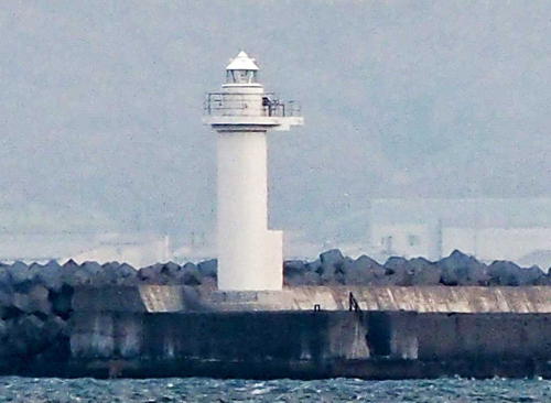
Date unknown. Active; focal plane 13 m (43 ft); green flash every 3 s. 11 m (36 ft) round cylindrical concrete tower with lantern and gallery, painted white. Brad Bouchard has a 2007 photo, Trabas has SJP's photo (also seen at right), FOAL has a photo (halfway down the page, on the right), another photo shows this light in front of the North Breakwater light, and Google has a sea view and a satellite view. The light and the North Breakwater light frame the main harbor entrance. Located at the west end of the detached East Breakwater. Accessible only by boat. Site and tower closed. ARLHS JPN-1011; JCG-0509; Admiralty M6904; NGA 1486.
Wakkanai Kō East Breakwater East Head
Date unknown. Active; focal plane 14 m (46 ft); two red flashes every 6 s. 13 m (43 ft) round cylindrical concrete tower with lantern and gallery, painted red. FOAL has a photo (near the bottom of the page), Trabas has SJP's distant view and Google has a satellite view and a very distant sea view. Located at the east end of the East Breakwater, where it marks the southern entrance to the harbor. Accessible only by boat. Site and tower closed. ARLHS JPN-1010; JCG-0505; Admiralty M6905; NGA 1486.5.
Koetoi Saki
Date unknown. Active; focal plane 12 m (39 ft); quick-flashing white light. 12 m (39 ft) tapered round concrete tower; upper half painted black, lower half yellow. FOAL's page has a closeup photo, Trabas has SJPs photo, and Bing has a distant satellite view. This light marks a reef on the east side of Wakkanai harbor. Located about 1400 m (0.9 mi) off Koetoi Point, a promontory about 5 km (3 mi) east of the Wakkanai waterfront. Accessible only by boat, but easily seen from shore. Site open, tower closed. JCG-0503; Admiralty M6900; NGA 1508.

East Breakwater West Head Light, Wakkanai
photo copyright Selector Jonathon Photography; used by permission

Wakkanai City: Cape Sōya Area Lighthouses
Cape Sōya is the northernmost point of Hokkaidō, 43 km (26.7 mi) from Cape Kriljon, Sakhalin. On very clear days it is possible to see the mountains of Sakhalin across the strait.
* Tomiiso Kō
1964. Active; focal plane 13 m (43 ft); continuous green light with a more intense flash every 6 s. 10 m (33 ft) round cylindrical concrete tower with lantern and gallery, painted white. Trabas has SJP's photo, FOAL's page has photos, Google has a street view, and Bing has a satellite view. Located at the end of the main breakwater of Tomiiso, a fishing port about 12 km (7.5 mi) southwest of Cape Sōya. Accessible by walking the pier. Site open, tower closed. ARLHS JPN-999; JCG-0502; Admiralty M6898; NGA 1516.
* Sōya Gyoko West Breakwater
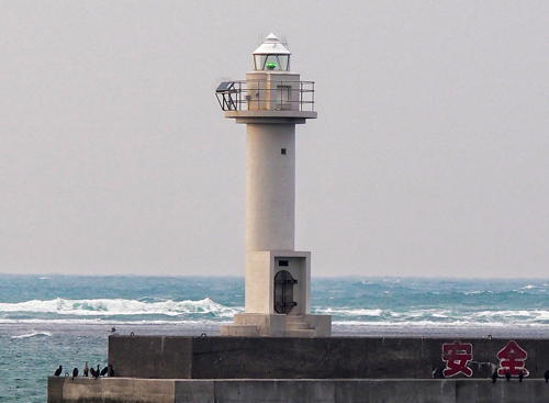
1977. Active; focal plane 13 m (43 ft); green light, 2 s on, 2 s off. 11 m (36 ft) round cylindrical concrete tower with lantern and gallery. Entire lighthouse is white. Trabas has SJP's photo (also seen at right), FOAL's page has photos, Google has a street view, and Bing has a satellite view. Located at the end of the end of the west breakwater at Sōya Gyoko, about 3.2 km (2 mi) north of the Tomiiso harbor. Accessible by walking the pier. Site open, tower closed. JCG-0501; Admiralty M6897.6; NGA 1520.
* Sōya Gyoko Hamakita Breakwater
1989. Active; focal plane 13 m (43 ft); red light occulting once every 4 s. 11 m (36 ft) round cylindrical concrete tower with lantern and gallery. Entire lighthouse is red. Trabas has SJP's photo, FOAL's page has photos, Google has a street view, and Bing has a satellite view. Located at the end of the end of the south breakwater at a different Sōya Gyoko harbor, about 4 km (2.5 mi) west southwest of Cape Sōya. Accessible by walking the pier, which is used by fishermen. Site open, tower closed. JCG-0500; Admiralty M6897.4; NGA 1522.

Sōya Gyoko West Breakwater Light, Wakkanai
photo copyright Selector Jonathon Photography; used by permission
* Sōya Misaki (Cape Sōya) (3)
1954 (station established 1885). Active; focal plane 40 m (131 ft); four white flashes every 30 s. 17 m (56 ft) square cylindrical concrete tower with lantern and gallery, attached to a 1-story service building. Tower painted with red and white horizontal bands. A photo is at right, Trabas has SJP's photo, Lighthouse-Japan.com has a page with many photos, FOAL also has a page with photos, a 2010 photo is available, Wikimedia has a photo, Google has a street view and a satellite view. This lighthouse marks the northern tip of Japan, facing Russia's Cape Kriljon, Sakhalin, across the 43 km (27 mi) of the La Pérouse Strait. The cape itself is marked by a well-visited monument. Nearby is a memorial to the victims of Korean Air Lines Flight 007, which was shot down by Soviet fighters in 1983, and another memorial to the crew of the U.S. Navy submarine Wahoo, sunk just off the cape in October 1943, and to the Japanese seamen killed in the sub's attacks. By contrast the lighthouse on the hill above these attractions doesn't seem to get much attention. The original lighthouse, an octagonal cast iron tower, was destroyed by fire in May 1911. The second lighthouse was built in 1912 and served until replaced by the present light in 1954. Located 120 m (400 ft) south of the point of the cape, 40 km (25 mi) east northeast of Wakkanai. Site open, tower closed. . ARLHS JPN-594; JCG-0432; Admiralty M6896; NGA 1524.
Sōya Kō North Breakwater
1966. Active; focal plane 14 m (46 ft); red light, 2 s on, 2 s off. 11 m (36 ft) round cylindrical concrete tower with lantern and gallery, painted red. FOAL's page has photos, Trabas has SJP's photo, and Google has a distant street view and a satellite view. Located at the end of the north breakwater of Sōya, the port just southeast of and sheltered by Sōya Misaki. Accessible only by boat. Site open, tower closed. ARLHS JPN-979; JCG-0431; Admiralty M6897; NGA 1532.
* Higashiura Kō North Breakwater
1983. Active; focal plane 14 m (46 ft); red flash every 3 s. 11 m (36 ft) round cylindrical concrete tower with lantern and gallery, painted red. FOAL's page has photos, and Google has a distant street view and a satellite view. Located at the end of the original north breakwater of Higashiura, a port about 25 km (15 mi) southeast of Sōya Misaki. Accessible by walking the pier. Site open, tower closed. JCG-0429.5; Admiralty M6896.5; NGA 1536.

Sōya Misaki Light, Wakkanai, June 2014
Flickr Creative Commons photo by Kzaral

Sarufutsu Town Lighthouse
* Hamaonishibetsu (Hama Onishibetsu)
1975. Active; focal plane 26 m (85 ft); white flash every 5 s; also a continuous white spotlight (JP-0429) illuminates the Todo Shima reef to the northeast. Approx. 15 m (49 ft) square cylindrical concrete tower with lantern and double gallery, attached to a 1-story concrete equipment building. Lighthouse painted with red and white horizontal bands. Misty's Tour has a photo, FOAL's page has excellent photos, and Google has a street view and a satellite view. Located on the west side of Hamaonishbetsu, a small port about 25 km (15 mi) southeast of Sōya Misaki. Site open, tower closed. . ARLHS JPN-081; JCG-0428; Admiralty M6895.4; NGA 0200.

Hamatonbetsu Town Lighthouses
Hamatonbetsu (Tonbetsu, Tonbetu) Kō
Date unknown. Active; focal plane 14 m (46 ft); red flash every 3 s. 11 m (36 ft) round cylindrical concrete tower with lantern and gallery. Entire lighthouse is red. Lighthouse Visits has a photo and Google has a satellite view and a distant street view. Located at the end of the main breakwater of Hamatonbetsu. Site status unknown. ARLHS JPN-1002; JCG-0427.3; Admiralty M6895.2; NGA 0202.
* Kamui Misaki (Cape Kamui)
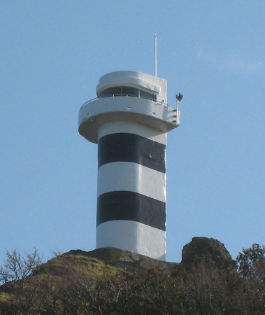
1962. Active; focal plane 49 m (161 ft); white flash every 15 s. 18 m (59 ft) U-shaped cylindrical concrete tower with lantern and gallery, rising from a 1-story keeper's house. Tower painted with black and white horizontal bands. A photo is at right, FOAL's page has photos, Motofumi Yamaura has a 2016 photo, and Google has a street view and a satellite view. The rugged cape is a conspicuous landmark on the northern coastline, and a tunnel has been built to carry the coastal highway (route 238) through the ridge. Note: there is another (better known) Kamui Misaki lighthouse in Southwestern Hokkaidō. Located on a sharp and steep promontory, just off the coastal highway, about 12 km (7.5 mi) southeast of Hamatonbetsu. Site status unknown, but the lighthouse is easy to see from a parking area provided on the old road around the point of the cape. Tower closed. . ARLHS JCG-0427; Admiralty M6895; NGA 0204.

Esashi Town Lighthouses
* Menashidomari Kō
Date unknown. Active; focal plane 14 m (46 ft); red light, 2 s on, 2 s off. 11 m (36 ft) round cylindrical concrete tower with lantern and gallery. Entire lighthouse is red. Lighthouse Visits has a photo and Google has a street view and a satellite view. The light is listed by NGA as "Kamui Misaki Southeast." Located at the end of the west breakwater of Menashidomari, a small port sheltered on the west by Cape Kamui. Apparently accessible by walking the pier. Site open, tower closed. ARLHS JPN-891; JCG-0426; Admiralty M6894.6; NGA 0208.
Kitami Eshashi (Esasi) Kō
Date unknown. Active; focal plane 13 m (43 ft); two red flashes every 6 s. 10 m (33 ft) round cylindrical concrete tower with lantern and gallery. Entire lighthouse is red. Lighthouse Visits has a photo and Google has a satellite view and a very distant street view. Located at the end of the detached north breakwater of Esashi, the capital of the Esashi District. Accessible only by boat. Site open, tower closed. ARLHS JPN-852; JCG-0425; Admiralty M6894.4; NGA 0216.

Kamui Misaki Light, Eshashi, November 2019
Google Maps photo by Pakkyara
* Yamausu Kō
Date unknown. Active; focal plane 12 m (39 ft); continuous green light with a more intense flash every 6 s. 9.5 m (31 ft) round cylindrical concrete tower with lantern and gallery. Entire lighthouse is white. Lighthouse Visits has a photo and Google has a street view and a satellite view. Located at the end of the south breakwater of Yamausu, a small fishing port about 15 km (9 mi) southeast of Eshashi. Apparently accessible by walking the pier. Site open, tower closed. ARLHS JPN-1017; JCG-0422; Admiralty M6893.7; NGA 0224.

Okhotsk Subprefecture Lighthouses

Ōmu Town Lighthouses
Otoineppu Misaki
1972. Active; focal plane 29 m (95 ft); white light, 2 s off, 2 s on. 15 m (49 ft) round cylindrical concrete tower with lantern and gallery, attached to a small square equipment room. Lighthouse painted with red and white horizontal bands. A Google street view is at right, FOAL's page has photos, Misty's Tour also has good photos, a 2017 photo is available, and Google has a satellite view. Located on the coastal highway about 4 km (2.5 mi) northwest of Ōmu. Site status unknown. . ARLHS JPN-497; JCG-0421; Admiralty M6893.6; NGA 0228.
Motoineppu Kō North Breakwater
1959. Active; focal plane 15 m (49 ft); red flash every 3 s. 11 m (36 ft) round cylindrical concrete tower with lantern and gallery, painted red. FOAL's page has photos and Google has a satellite view and a very distant street view. Located on the detached north breakwater of the Fukawa rice plant on the north side of Ōmu. Site status unknown. ARLHS JPN-914; JCG-0420; Admiralty M6893.5; NGA 0232.
Ōmu North Breakwater
1934. Active; focal plane 12 m (39 ft); two red flashes every 6s. 11 m (36 ft) round cylindrical concrete tower with lantern and gallery, painted red. FOAL's page has photos and Google has a satellite view and a distant street view. The lighthouse was relocated in 2005, when the breakwater was extended. Located on the north breakwater of the main harbor of Ōmu. Site status unknown. ARLHS JPN-940; JCG-0418; Admiralty M6892; NGA 0236.
Sawaki Kō Breakwater
1966. Active; focal plane 12 m (39 ft); green light, 2 s on, 2 s off. 10 m (33 ft) round cylindrical concrete tower with lantern and gallery, painted white. FOAL's page has photos and Google has a street view and a satellite view. Located on the north end of the main breakwater of Sawaki, about 8 km (5 mi) southeast of Ōmu. Accessible only by boat. Site and tower closed. ARLHS JPN-964; JCG-0417; Admiralty M6890; NGA 0244.

Okoppe Town Lighthouse
Saru (Saruru) Kō East Breakwater
1971. Active; focal plane 13 m (43 ft); continuous red light with a more intense flash every 3 s. 11 m (36 ft) round cylindrical concrete tower with lantern and gallery. Entire lighthouse is red. FOAL's page has photos and Google has a satellite view and a distant street view. Located on the east breakwater at Saru, about 12 km (7.5 mi) west of Monbetsu. Site status unknown. ARLHS JPN-962; JCG-0415; Admiralty M6889; NGA 0248.

Otoineppu Misaki Light, Ōmu, July 2014
Google Maps street view

Monbetsu City Lighthouses
A town of about 25,000 residents, Monbetsu is an important center of Japan's crab fishery.
* Monbetsu
1960. Active; focal plane 80 m (262 ft); white flash every 10 s. 13 m (43 ft) U-shaped cylindrical concrete tower with lantern and gallery, rising from a 1-story keeper's house. Tower painted with red and white horizontal bands. Tomokazu Yasuda's photo is at right, Misty's Tour has a good photo, FOAL's page has photos, a 2017 photo is available, and Google has a street view and a satellite view. Similar in design to the Kamui Misaki lighthouse. Located on a steep slope in a public park near the Okhotsk Garden in Monbetsu. Site open, tower closed. . ARLHS JPN-371; JCG-0414; Admiralty M6885; NGA 0252.
Monbetsu North Breakwater
1931. Active; focal plane 19 m (62 ft); red light occulting once every 6 s. 16 m (52 ft) round cylindrical concrete tower with lantern and gallery. Entire lighthouse is red. FOAL's page has a photo (near the bottom of the page), Google has a satellite view and a distant street view. Located at the end of the rather short north breakwater at Monbetsu. Site status unknown. ARLHS JPN-909; JCG-0411; Admiralty M6886; NGA 0256.
Monbetsu Detached Breakwater North Head
1972. Active; focal plane 12 m (39 ft); green flash every 3 s. 11 m (36 ft) round hourglass-shaped concrete tower with lantern and gallery. Entire lighthouse is white. FOAL's page has a photo (near the bottom of the page), and Google has a satellite view and a very distant street view. Located at the north end of the outer breakwater at Monbetsu. Site status unknown. ARLHS JPN-910; JCG-0412; Admiralty M6886.4; NGA 0260.
Monbetsu Outer Breakwater East Head
2001. Active; focal plane 13 m (43 ft); green flash every 3 s. 10 m (33 ft) round cylindrical concrete tower with lantern and gallery. Entire lighthouse is red. FOAL's page has a photo (last photo on the page) and Google has a satellite view. Located at the east end of the outer breakwater at Monbetsu. Site status unknown. ARLHS JPN-911; JCG-0410.9; Admiralty M6886.2; NGA 0262.
Monbetsu Inner Breakwater
1962. Active; focal plane 10 m (33 ft); continuous green light with a more intense flash every 5 s. 8.5 m (28 ft) concrete post light attached to a square 1-story concrete equipment room. Entire lighthouse is white. FOAL has a photo (near the bottom of the page) and Google has a street view and a satellite view. Located on the end of the inner breakwater of Monbetsu. JCG-0413; Admiralty M6887; NGA 0264.

Monbetsu Light, Monbetsu, October 2018
Google Maps photo by Tomokazu Yasuda

Kitami City Lighthouses
* Saroma Kō Guchi
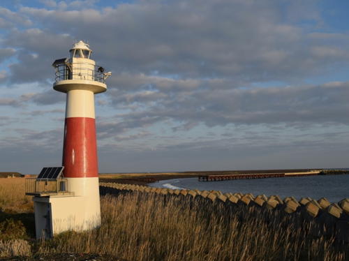
1966. Active; focal plane 14 m (46 ft); continuous red light with a more intense flash every 5 s. 13 m (43 ft) round tower with lantern and gallery, painted white with one red horizontal band. A 2017 photo is seen at the top of this page, Misty's Tour has a photo, FOAL's page has additional photos, and Google has a satellite view. Saroma Kō is often called Hokkaidō's largest lake, but it is not a lake at all--it is a lagoon enclosed by barrier beaches and connected to the Sea of Okhotsk by an inlet (guchi). In Japan, coastal lagoons occur only in this section of the Hokkaidō coastline. The lighthouse is located on the west side of the inlet, 13 km (8 mi) east of Yūbetsu. Site open, tower closed. . ARLHS JPN-961; JCG-0410; Admiralty M6884.4; NGA 0268.
Tokoro North Breakwater
1958. Active; focal plane 15 m (49 ft); red flash every 3 s. 9.5 m (31 ft) concrete post light mounted on a square 1-story concrete equipment room. Entire lighthouse is red. Lighthouse Visits has a good photo and Google has a satellite view and a very distant street view. Located at the end of the main (north) breakwater of Tokoro, about 12 km (7.5 mi) west of Cape Notoro. Site and tower closed. JCG-0408; Admiralty M6884; NGA 0272.

Abashiri City Lighthouses
Abashiri, a city of about 40,000 residents, is the capital of Okhotsk Subprefecture. Like Monbetsu it is an important fishing port.

*
Notoro Misaki (Cape Notoro)
1917. Active; focal plane 57 m (187 ft); white flash every 8 s. 21 m (69 ft) octagonal concrete tower with lantern and gallery, attached to a 1-story keeper's house. Tower painted with black and white horizontal bands. A photo appears at the top of this page, FOAL's page has many photos, Lighthouses of Japan has two photos, the Lighthouse of Japan site has excellent photos, Wikimedia has a photo, Misty's Tour has several photos, and Google has a street view and a satellite view. Located atop a cliff with a fine view of the sea, this historic lighthouse has become an important tourist attraction. The light was automated in 1980 and converted to solar power in 1996. Located on Cape Notoro about 8 km (5 mi) north of downtown Abashiri. Accessible by road and a short walk; parking provided. Site open, tower closed. . ARLHS JPN-435; JCG-0407; Admiralty M6882; NGA 0280.
Abashiri North Breakwater
1930. Active; focal plane 15 m (49 ft); two red flashes every 6 s. 13 m (43 ft) round cylindrical concrete tower with lantern and gallery. Entire lighthouse is red. Nicole Choi has a distant view, and Google has a satellite view and a distant street view. The north breakwater at Abashiri is the main breakwater for the port's original harbor. Located at the end of the breakwater. Accessible only by boat. Site and tower closed. ARLHS JPN-932; JCG-0405; Admiralty M6877; NGA 0288.
Abashiri East Breakwater
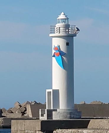
1965. Active; focal plane 14 m (46 ft); green light, 2 s on, 2 s off. 13 m (43 ft) round cylindrical concrete tower with lantern and gallery, painted white. Tatsushi Hirose's 2021 photo is at right, Misty's Tour has a photo, Rebecca Li has a closeup, FOAL's page has several photos, and Google has a street view and a satellite view. The decoration on the lighthouse depicts a clione, or sea angel, a species of free-swimming mollusk common in the Sea of Okhotsk. Located at the north end of the east breakwater of Abashiri. Site and tower closed. ARLHS JPN-931; JCG-0404; Admiralty M6878; NGA 0292.
Abashiri South Breakwater East End
1994. Active; focal plane about 16 m (52 ft); red flash every 3 s. 13 m (43 ft) round cylindrical concrete tower with lantern and gallery, painted red. FOAL has a photo (last red lighthouse on the page) and Google has a satellite view. The south breakwater has been extended considerably to the southeast, and this lighthouse and the next define the entrance to the city's new south harbor. Accessible only by boat. Site and tower closed. Located at the end of the breakwater. ARLHS JPN-2627; JCG-0403.9; Admiralty M6878.5; NGA 0293.
Abashiri Island Breakwater North End
2000. Active; focal plane 16 m (52 ft); green flash every 3 s. 12 m (39 ft) round cylindrical concrete tower with lantern and gallery, painted white. FOAL has a photo (last white lighthouse on the page) and Google has a satellite view and a very distant street view. The Island Breakwater is a detached breakwater sheltering the city's new south harbor. Accessible only by boat. Located at the north end of the breakwater. ARLHS JPN-933; JCG-0403.87; Admiralty M6878.6.
Masuura Kō
1990. Active; focal plane 14 m (46 ft); red light, 2 s on, 2 s off. 11 m (36 ft) round cylindrical concrete tower with lantern and gallery, painted red. A winter view is available, Lighthouse Visits has a photo, and Google has a satellite view and a distant street view. Located on the north breakwater sheltering the harbor of Masuura, a small fishing port on the south side of Abashiri. Site status unknown. ARLHS JPN-903; JCG-0403.8; Admiralty M6876; NGA 0294.

Abashiri East Breakwater Light, June 2021
Google Maps photo by Tatsushi Hirose

Shari Town (Shiretoko Peninsula West Side) Lighthouses
The rugged Shiretoko Peninsula projects 70 km (43 mi) into the Sea of Okhotsk, making it a significant obstacle to navigation. The wild outer half of the peninsula is protected as the Shiretoko National Park. In the language of Japan's indigenous Ainu people, shiretoko means "end of the earth." For lighthouses on the east side of the peninsula, see Eastern Hokkaidō.
Utoro North Breakwater
1960. Active; focal plane 15 m (49 ft); continuous red light with a more intense flash every 6 s. 13 m (43 ft) round cylindrical concrete tower with lantern and gallery, painted red. A 2009 photo is available and Google has a sea view and a satellite view. Located at the end of the north breakwater of Utoro, on the west side of the Shiretoko Peninsula. Site status unknown. ARLHS JPN-1008; JCG-0402; Admiralty M6870; NGA 0304.
Utoro East Breakwater
1959. Active; focal plane 12 m (39 ft); green flash every 3 s. 11 m (36 ft) round cylindrical concrete tower with lantern and gallery, painted white. A 2009 photo is available and Google has a sea view and a satellite view. Located at the end of the east breakwater of Utoro, on the west side of the Shiretoko Peninsula. Site status unknown. ARLHS JPN-1007; JCG-0403; Admiralty M6872; NGA 0300.
Utoro
1969. Active; focal plane 142 m (466 ft); white flash every 15 s. 20 m (66 ft) round cylindrical concrete tower with lantern and gallery, attached at one end of a 1-story keeper's house. Tower painted with black and white horizontal bands. This light, built to help guide ships around the Shiretoko Peninsula, is located in a wild area near the national park boundary. A former Coast Guard page mentioned a nearby waterfall and warned that brown bears sometimes forage around the lighthouse. The Lighthouse of Japan site has excellent photos, FOAL's page has additional photos, M. Nobu has a 2021 photo, Hideku Kaku has a distant view, Misty's Tour has a view of the spectacular site, and Google has a satellite view. The color of the light was changed from green to white in 2009, when a new lens was installed. Located on a ridge northeast of the port of Utoro. Site and tower closed. . ARLHS JPN-733; JCG-0401; Admiralty M6866; NGA 0296.
Shiretoko Misaki (Cape Shiretoko)
1963. Active; focal plane 102 m (335 ft); two white flashes every 20 s. 12 m (39 ft) U-shaped cylindrical concrete tower with lantern and gallery, attached at one end of a 1-story keeper's house. Tower painted with black and white horizontal bands. A photo is at right, FOAL's page has additional photos, Lighthouse Visit's page has a photo, a closeup is available, and Google has a satellite view. This light marks the tip of the Shiretoko Peninsula. It also marks the northwestern entrance to the Nemuro Strait, which separates Hokkaidō from Kunishiri, one of the Kuril Islands occupied by Russia but claimed by Japan. Accessible only by boat (there is no road through the national park), and landing at this exposed location is difficult. Site and tower closed. . ARLHS JPN-579; JCG-0218; Admiralty M6862; NGA 0308.

Shiretoko Misaki Light, Shiretoko National Park, October 2008
Wikimedia Creative Commons photo by Myroad000x

Information available on lost lighthouses:

Notable faux lighthouses:

Adjoining pages: North: Southern Sakhalin | East: Eastern Hokkaidō | South: Northwestern Hokkaidō | West: Rishiri and Rebun

Return to the Lighthouse Directory index | Ratings key

Posted June 8, 2006. Checked and revised April 5, 2023. Lighthouses: 43. Site copyright 2023 Russ Rowlett and the University of North Carolina at Chapel Hill.