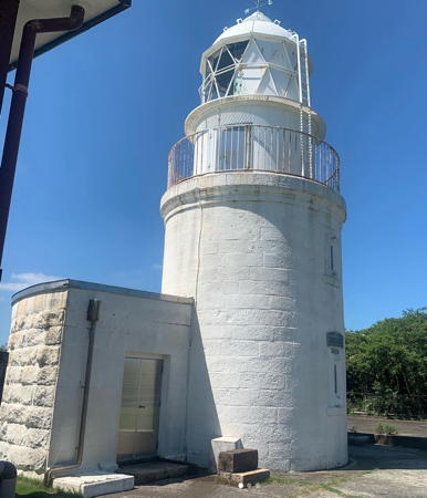
Lighthouses of Japan: Northern Wakayama Prefecture

The nation of Japan, known in Japanese as Nihon or Nippon (日本), occupies an archipelago off the east coast of Asia. The four main islands are Hokkaidō in the north, Honshū (the largest) in the center, Shikoku in the south, and Kyūshū in the southwest. The country includes thousands of other islands of all sizes; among them the Ryūkyū (Nansei) Islands are a long chain extending to the southwest and including the large island of Okinawa, and the Nanpō Islands are another long chain extending south into the Pacific Ocean. Much of Japan is mountainous but the coastal regions are densely populated and urbanized; the country's population is about 126 million.

Japan is divided into 47 prefectures. This page lists lighthouses of the northern part of Wakayama Prefecture, which faces southwest on the Pacific Ocean southeast of Ōsaka. The prefecture includes a large part of the scenic Kii Peninsula (Kii-hanto), which projects southward into the Pacific and is the southernmost coast of Honshū. The lighthouses of this page are on the west side of the peninsula, from Tanabe north to the border of Ōsaka Prefecture.

In Japanese the word for a lighthouse is tōdai or toudai (灯台). The words saki and misaki are for capes and headlands, hana ("nose") is a promontory, hantō is a peninsula, shima (also spelled sima or jima) is an island, bae is a reef, iwa or shi is a rocky reef, amase or se is a shoal, wan is a bay, nada is a sound or basin, kaikyō is a strait, kawa is a river, and or minato is a harbor.

Lighthouses in Japan are operated and maintained by the Japanese Coast Guard's Maritime Safety Agency. On Honshū there is usually at least one Coast Guard Section Office in each prefecture; Wakayama has two, at Tanabe and at Wakayama City. The Tanabe office maintains lighthouses near that city, and the Wakayama office maintains the lighthouses from Hidaka northward.

ARLHS numbers are from the ARLHS World List of Lights. JCG numbers are the Japanese Coast Guard's light list numbers. Admiralty numbers are from volume M of the Admiralty List of Lights & Fog Signals. U.S. NGA List numbers are from Publication 112.

General Sources
Lighthouses in Japan - Wakayama
A site providing photos and data for most major Japanese lighthouses.
Lighthouse-Japan.com - Wakayama
Another comprehensive site with photos and notes from visits to many lighthouses.
Form of a Lighthouse - Wakayama
Another site with many photos of Japanese lighthouses and notes on how to find them; cited below as FOAL.
Lighthouse Visits
This site has photos for many lighthouses in this area.
Misty's Japanese Lighthouse Tour - Wakayama
Photos and a few notes for lighthouses in all parts of the country.
Online List of Lights - Japan
Photos posted by Alexander Trabas.
Lighthouses in Wakayama Prefecture
Photos by various photographers available from Wikimedia.
Richard Henry Brunton
Wikipedia article on the Scottish engineer who built most of Japan's oldest lighthouses, including the surviving Sugashima Light and the first lighthouse at Anori Saki.
Japan: Modern Lighthouses
Historic postcard views posted by Michel Forand.
Navionics Charts
Navigation chart for the Wakayama coast.
Saika Saki Light
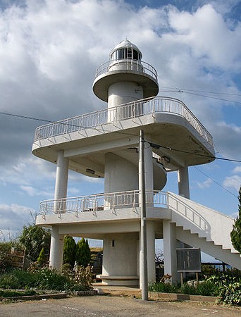
Saika Saki Light, Wakayama, December 2008
Wikimedia Creative Commons photo by 663highland
Tanabe Coast Guard District Lighthouses

Tanabe City Lighthouses
Tanabe is a city of about 70,000 residents facing Muroto Bay, a natural harbor sheltered by the headland of Bansho Hana.

* Mori West Breakwater
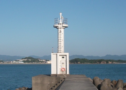
1966. Active; focal plane 11 m (36 ft); continuous green light with a more intense flash every 6 s. 8.5 m (28 ft) concrete post attached to a square 1-story concrete equipment room. Lighthouse covered with white tiles. Trabas has a closeup photo and Google has a street view and a satellite view. Located at the end of a short breakwater on the west side of the entrance to the sheltered Mori harbor, on the south side of Tanabe. Accessible by walking the pier. Site open, tower closed. ARLHS JPN-1964; JCG-2932; Admiralty M5981.6; NGA 6872.
* Tanabe Kō Range Rear
Date unknown. Active; focal plane 22 m (72 ft); continuous yellow light. 18 m (59 ft) triangular skeletal tower painted with red and white horizontal bands carrying a triangular daymark pointed up. Trabas has a photo and Google has a street view and a satellite view. This is the entrance range for Tanabe. The front light is on a 10 m (33 ft) post. Located off a side street in Tanabe. Site open, tower closed. JCG-2927; Admiralty M5980.81; NGA 6860.
Egawa East Breakwater
1968. Active; focal plane 13 m (43 ft); red light, 2 s on, 2 s off. 9 m (30 ft) concrete post attached to a square 1-story concrete equipment room. Lighthouse covered with red tiles. Trabas has a closeup photo and Google has a fuzzy street view and a satellite view. Located at the end of the east breakwater of the Egawa harbor, on the west side of Tanabe. Site status unknown. ARLHS JPN-1975; JCG-2925; Admiralty M5980.4; NGA 6852.
Tanabe Takashi Kansaki
Date unknown. Inactive; charted as a landmark by Navionics. Approx. 8 m (26 ft) concrete post attached to a square 1-story concrete equipment room. Entire lighthouse is white. Kanoko Tanaka has a view from the mainland, a 2023 view and another photo (identified as #2918, halfway down the page) are also available, and Google has a satellite view. Located on an islet at the north side of the entrance to Tanabe harbor. It appears that one can cross to the island at low tide. Site open, tower closed. ex-JCG-2918.
Tanabe Kō (Tanabe Okinoshima) (2)
1962. Active; focal plane 15 m (49 ft); white flash every 3 s. Approx. 10 m (33 ft) round tapered concrete tower with gallery. Entire lighthouse is white. FOAL has two photos (bottom of the page), Trabas has a view, and Google has a satellite view. Located on a small island in the entrance to Tanabe Bay, about 3 km (2 mi) northwest of the Bansho Hana lighthouse. Accessible only by boat. Site open, tower closed. ARLHS JPN-1976; JCG-2918; Admiralty M5978; NGA 6832.
Nakashima (Kyōto Daigaku) Observation Tower
Date unknown. Active; focal plane 19 m (62 ft); two short white flashes followed by one long white flash every 8 s. 19 m (62 ft) robust round post supporting a round equipment building; a spiral stairway provides access to the equipment. Entire structure painted yellow. Trabas has a photo, FOAL has a photo (bottom of the page), and Google has a satellite view. This tower is a storm surge monitoring station maintained by Kyōto University. Located on Naka Shima, a mostly submerged rock in the entrance to Muroto Bay, about 800 m (1/2 mi) southeast of Okinoshima. Accessible only by boat. Site open, tower closed. JCG-2914.5; Admiralty M5978.5.
 
* Kii Sakai Kō
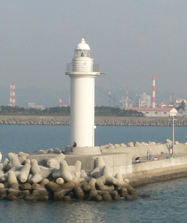
1984. Active; focal plane 12 m (39 ft); green flash every 3 s. 8 m (26 ft) concrete post attached to a square 1-story concrete equipment room. Entire lighthouse is white. A Coast Guard photo is at right, Trabas has a photo, a 2021 photo is available, and Google has a satellite view and a distant street view. NGA lists this light as "Sima - Haya Wan." Located at the end of the south (main) breakwater of the Sakai fishing port at Haya, northwest of Tanabe. Accessible by walking the pier. Site open, tower closed. ARLHS JPN-1969; JCG-2916.5; Admiralty M5977.7; NGA 6836.
Kii Sakai Light
Kii Sakai Kō Light, Tanabe
Japanese Coast Guard Tanabe Office photo

Minabe Town Lighthouse
Metsu Saki (Metsusaki)
1998. Active; focal plane 8 m (26 ft); six quick light flashes and one long white flash every 15 s. 8 m (26 ft) round cylindrical concrete tower centered on a large square stone pier. Upper half of the lighthouse painted yellow, lower half black. Trabas has a photo, a distant view (#2935.5, halfway down the page) and a drone view are available, and Google has a satellite view. Located at the end of a reef extending from a promontory at Minabe. Accessible only by boat. Site open, tower closed. JCG-2935.5; Admiralty M5977.8.

Inami Town Lighthouse
* Inami Yokoshima Breakwater
1966. Active; focal plane 13 m (43 ft); two red flashes every 6 s. 8.5 m (28 ft) concrete post attached to a square 1-story concrete equipment room. Lighthouse covered with red tiles. Trabas has a closeup photo, a 2023 drone view is available, Google has a satellite view and a distant street view. Located at the end of the east breakwater of Inami. Accessible by walking the pier. Site open, tower closed. ARLHS JPN-1946; JCG-2937; Admiralty M5977; NGA 6884.

Gobō City Lighthouse
Gobō Katsuo Shima (Katuoshima)
1972. Active; focal plane 18 m (56 ft); white flash every 4 s. 15 m (49 ft) round white concrete tower. Trabas has a photo, another photo (#2938, halfway down the page) is available, Hideki Nishioka has a view from the sea, and Google has a satellite view. Located on a small island about 4 km (2.5 mi) south of Gobō. Accessible only by boat. Site status unknown. ARLHS JPN-1940; JCG-2938; Admiralty M5974; NGA 6888.

Mihama Town Lighthouse
#Kii Hino Misaki (2)
1951 (station established 1895). Replaced and demolished in 2017. This was a 14 m (46 ft) round cylindrical concrete tower with lantern and gallery, attached to a 1-story concrete equipment building. Entire lighthouse painted white. 3rd order Fresnel lens. Lighthouse-Japan.com has good 2007 photos and Misty's Tour has another photo, but Google's satellite view shows that the building has been demolished. FOAL's page has photos of the new lighthouse under construction in March 2017. The first lighthouse was destroyed by a U.S. air raid in 1945. Site open.
* Kii Hino Misaki (3)
2017 (station established 1895). Active; focal plane 127 m (417 ft); three white flashes every 12 s. 17 m (56 ft) octagonal concrete tower with lantern and gallery, painted white. A September 2022 photo (seen at right) shows the completed lighthouse, Chie Ikeda has a 2022 photo, a 2018 photo is available, Trabas has an excellent closeup, Chiumi Morimoto has a nice 2021 view, and Google has a satellite view. One of Japan's most important lighthouses, this light stands at the gateway to the Kii Strait and Inland Sea (Seto Naikai). Its light has a range of 39 km (24 mi). Located at the tip of a long promontory about 10 km (6 mi) west of Gobō. Accessible by road; parking available. Site open, tower closed. . ARLHS JPN-255; JCG-3301; Admiralty M5970; NGA 6900.

2017 Kii Hino Misaki Light, Mihama, September 2022
Instagram photo by asa244_0109

Wakayama Coast Guard District Lighthouses

The lights of the Wakayama Coast Guard District face the Kii Strait, which is not a narrow strait but a roughly circular bay bordered by Honshū on the east, Shikoku on the west, and Awaji Shima on the north. At its northeastern corner Kii Strait connects to Ōsaka Bay and the Inland Sea via the narrow Kitan Strait, thus providing the heavily-traveled passage between the Pacific Ocean and the Inland Sea.

Hidaka Town Lighthouses
Ao Kō North Breakwater
1974. Active; focal plane 13 m (43 ft); red light, 3 s on, 3 s off. 10 m (33 ft) concrete post attached to a square 1-story concrete equipment room. Entire lighthouse is red. Trabas has a photo and Google has a street view and a satellite view. Located on the detached outer breakwater of Ao harbor, on the north side of the Hino Misaki peninsula. Accessible only by boat. Site open, tower closed. ARLHS JPN-1932; JCG-3302; Admiralty M5969.6; NGA 6904.
Naka Iso
1970. Active; focal plane 17 m (56 ft); two white flashes every 5 s. 16 m (52 ft) round concrete tower, painted black with a red horizontal band. Trabas has a photo, another photo (#3304, halfway down the page) is available, Kenichiro Asai has a distant view, and Google has a satellite view. Located on a rocky reef about 5 km (3 mi) north of Hino Misaki. Accessible only by boat. Site open, tower closed. JCG-3304; Admiralty M5969.4; NGA 6912.

Yura Town Lighthouse
Taka Shima
Date unknown. Active; focal plane 15 m (49 ft); six quick white flashes followed by one long white flash every 15 s. 14 m (46 ft) round concrete tower, upper half painted yellow and lower half painted black. Trabas has a good photo, another photo (#3315, less than halfway down the page) is available, and Google has a satellite view. Located on a rocky reef about 5 km (3 mi) southeast of Hirogawa. Accessible only by boat. Site open, tower closed. JCG-3315; Admiralty M5968.3; NGA 6948.

Hirogawa Town Lighthouse
#Yuasa Hiro (Yuasahiro)
1998. Inactive since 2014. This was an 8.5 m (28 ft) concrete post attached to a square 1-story equipment room, covered in white ceramic tile. The light was deactivated in March 2014 and Google's satellite view confirms that it has been removed. Formerly located at the end of the north breakwater at Yuasa. Site open. ARLHS JPN-1988; ex-JCG-3317; ex-Admiralty M5967.9; ex-NGA 6954.

Arida Town Lighthouses
* Kii Myazakino Hana
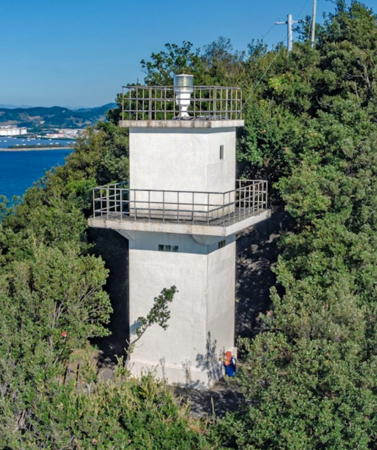
1966. Active; focal plane 81 m (266 ft); white light occulting once every 8 s. 8.5 m (28 ft) square cylindrical concrete tower with gallery, covered with white ceramic tile. Yuki Tanaka's photo is at right, Lighthouse-Japan.com has closeup photos, FOAL's page has photos, Toshifumi Kishi has a closeup street view, and Google has a distant satellite view. The lighthouse commands a specatcular view. Accessible by a hiking trail; some local knowledge will be needed to find it. Located on the tip of a sharp, forested promontory projecting into the Kii Strait about 5 km (3 mi) southwest of Arida. Site open, tower closed. . ARLHS JPN-256; JCG-3319; Admiralty M5967.8; NGA 6960.
Shimotsu (Shimotu, Okinoshima)
Date unknown. Active; focal plane 94 m (308 ft); white flash every 4 s. 13 m (43 ft) square cylindrical concrete tower with lantern and gallery, rising from a 1-story concrete equipment house. Entire lighthouse is white. A distant view is available, Trabas has a distant view, and Google has a satellite view. The company that installed the solar array for the lighthouse has a page with a closeup photo. Located on a small island about 4 km (2.5 mi) west southwest of the entrance to Shimotsu. Accessible only by boat. Site status unknown. ARLHS JPN-570; JCG-3320; Admiralty M5967.4; NGA 6968.
Shimotsu West (Nishino Ura) Breakwater
Date unknown. Active; focal plane 12 m (39 ft); red flash every 3 s. 9.5 m (31 ft) concrete post attached to a square 1-story concrete equipment room. Entire lighthouse is red. FOAL has photos (lower half of the page), Trabas has a closeup photo, and Google has a street view and a satellite view. Located on a breakwater on the southwest side of Shimotsu harbor. This breakwater is not walkable. Accessible only by boat. Site open, tower closed. JCG-3332; Admiralty M5967.3; NGA 6996.
Shimotsu Kamanoshimo Breakwater
Date unknown. Active; focal plane 13 m (43 ft); green light occulting once every 8 s. 10 m (33 ft) round cylindrical concrete tower attached to a 1-story concete equipment room. Entire lighthouse is white. Trabas has a photo and Google has a satellite view and a distant street view showing the top of the light. Located on a short breakwater on the north side of the entrance to Shimotsu. Accessible only by boat. Site status unknown. ARLHS JPN-1971; JCG-3329; Admiralty M5967; NGA 6984.
Tsubune (Tubune) Hana
Date unknown. Active; focal plane 29 m (95 ft); white light, 3 s on, 3 s off; also a continuous white spotlight (JCG-3328) illuminates a nearby reef. 9.5 m (31 ft) round hourglass-shaped white concrete tower. Trabas has a photo and Google has a satellite view. Located atop a steep promontory on the north side of the entrance to Osaki Bay. Site and tower closed (the light is in an oil tank farm). ARLHS JPN-685; JCG-3327; Admiralty M5966.5; NGA 6980.

Kii Myazakino Hana Light, Arida, November 2019
Google Maps photo by Yuki Tanaka

Kainan City Lighthouses
#Kainan Kō South Breakwater (1)
1969. Replaced and demolished in 2017. This was a 9.5 m (31 ft) round hourglass-shaped concrete tower. Entire lighthouse was red. In October 2017 the Admiralty announced a new light (focal plane 9 m, red flash every 3 s) on a 5 m (16 ft) post. Google's satellite view shows this new light and Trabas has a photo. The Kainan breakwaters were completely rebuilt in 2015-17. Located on the short south breakwater at the entrance to Kainan harbor. Site open but difficult to reach, tower closed. ARLHS JPN-1951. Active light: JCG-3337; Admiralty M5966; NGA 7000.
#Kainan Kō North Breakwater (1)
Date unknown. Replaced and demolished in 2017. This was a 10 m (33 ft) round hourglass-shaped concrete tower. Entire lighthouse was white. The active light (focal plane 11 m (36 ft); green flash every 3 s) is on a 6 m (20 ft) post. No photo of the original light is available. FOAL has November 2017 photos of the new light, Trabas has a photo and it is also seen in Google's satellite view. Located on the north breakwater at the entrance to Kainan harbor. Site status unknown. ARLHS JPN-1950. Active light: JCG-3338; Admiralty M5966.2; NGA 7004.

Wakayama City Lighthouses
* Wakaura Gyoko West Breakwater
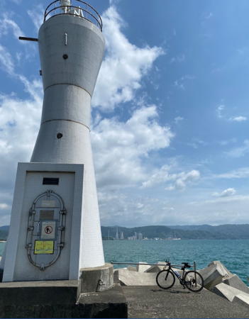
Date unknown. Active; focal plane 12 m (39 ft); continuous green light with a more intense flash every 5 s. 10 m (33 ft) round hourglass-shaped concrete tower. Entire lighthouse is white. A photo is at right, Coast Guard has a photo, Trabas has a photo and Google has a satellite view and a street view across the harbor. Located on the west breakwater of a small boat harbor at the southeastern corner of Wakayama city. Accessible by walking the pier. Site open, tower closed. JCG-3340; Admiralty M5965.2; NGA 7008.
* Saika (Saiga) Saki Kō (Wakayama Shimotsu Kō)
1983. Active; focal plane 13 m (43 ft); two green flashes every 8 s. 10 m (33 ft) concrete post attached to a square 1-story equipment room, covered in white ceramic tile. Trabas has a photo and Google has a street view and a satellite view. Located at the end of the south breakwater at the harbor sheltered by Saika Saki, on the south side of Wakayama. Accessible by walking the pier. Site open, tower closed. ARLHS JPN-1967; JCG-3340.5; Admiralty M5965.05; NGA 7016.

Wakaura Gyoko West Breakwater Light, Wakayama, April 2021
Google Maps photo by TAKA SSY
** Saika (Saiga) Saki
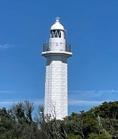
1960. Active; focal plane 75 m (246 ft); white flash every 8 s.14 m (46 ft) round cylindrical concrete tower with lantern and gallery. the tower is also surrounded by two large observation platforms accessed by stairways. Entire lighthouse is white. A photo is at the top of the page, Taku Suzuki has a 2022 photo, Trabas has a photo, Lighthouse-Japan.com has a page with photos, Misty's Tour has additional photos, and Google has a street view and a satellite view. The observation platforms provide a wide view of the Kii Strait and the coast of Shikoku. Located on a high promontory about 7 km (4.5 mi) south of Wakayama. Parking is provided next to the lighthouse. Site open, observation platforms open, tower closed. . ARLHS JPN-525; JCG-3341; Admiralty M5965; NGA 7018.
Wakayama Kō South Breakwater (2?)
Date unknown. Active; focal plane 13 m (43 ft); two red flashes every 7 s. 13 m (43 ft) round concrete tower with lantern and gallery. Entire lighthouse is red. Trabas has a photo, Kazutaka Tsutsui has a photo, and Google has a satellite view and a very distant street view. This light was formerly located at the end of a short pier on the south side of the traditional harbor of Wakayama. That pier no longer serves as a breakwater; satellite photos show a newer south outer breakwater that encloses it. The light was either relocated or demolished and rebuilt. Located at the end of the new south breakwater. Accessible only by boat. Site and tower closed. JCG-3344; Admiralty M5963; NGA 7028.
Wakayama Kō North Breakwater
Date unknown. Active; focal plane 16 m (52 ft); two green flashes every 7 s. 13 m (43 ft) round concrete tower with lantern and gallery, painted white. Thomas Prinz posted the photo at right, Trabas has a photo, Sakae Fuchikami has a 2022 photo, Negoro Nemu has a photo, and Google has a satellite view. Located at the end of the north breakwater of the traditional harbor of Wakayama. This pier does not appear to be walkable but there should be a good view from ferries crossing the Kii Strait to Tokushima, Shikoku. Site and tower closed. ARLHS JPN-1987; JCG-3345; Admiralty M5964; NGA 7032.
Wakayama Kita Kō West Breakwater
Date unknown. Active; focal plane 17 m (56 ft); red light, 3 s on, 3 s off. 17 m (56 ft) round concrete tower with lantern and gallery, painted red. Trabas has a distant view and Google has a satellite view. Land has been filled south of this pier for a new industrial area, so the "breakwater" is now only a few tens of meters long. Located on the south side of the entrance to Wakayama's newer harbor; possibly accessible. Site status unknown. ARLHS JPN-1955; JCG-3353; Admiralty M5961.6; NGA 7036.
Wakayama North Breakwater Light
North Breakwater Light, Wakayama, October 2009
ex-Panoramio photo copyright Thomas Prinz; permission requested
Wakayama Kita Kō North Breakwater
Date unknown. Active; focal plane 17 m (56 ft); green light, 3 s on, 3 s off. 17 m (56 ft) round concrete tower with lantern and gallery, painted white. Trabas has a distant view and Google has a satellite view. Located at the end of the breakwater on the north side of the entrance to Wakayama's newer harbor. Site status unknown. ARLHS JPN-1954; JCG-3352; Admiralty M5961.8; NGA 7034.
* Takura Saki
1956. Active; focal plane 49 m (161 ft); white light, 3 s on, 3 s off; in addition, a continuous white spotlight (JCG-3355) illuminates a reef 300 m (330 yd) northwest. 11 m (36 ft) concrete post with gallery, rising from a 1-story hexagonal concrete equipment shelter. Entire lighthouse is white. Trabas has a photo, a 2018 closeup is available, Lighthouse-Japan.com has a page with good photos, FOAL's page has photos, Misty's Tour has another photo, Toshifumi Kishi has a street view, and Google has a satellite view. Takura Saki is a promontory at the north end of the Kii Strait and the south end of Ōsaka Wan; the entrance to the bay through the Kitan Strait is only 11 km (6.5 mi) wide. A bridge over the strait has been proposed. Accessible by a hiking trail. Located on the cape, about 7 km (4.5 mi) west of Wakayama. Site open, tower closed. . ARLHS JPN-622; JCG-3354; Admiralty M5961; NGA 7040.
* Kada Kō Outer Breakwater
1989. Active; focal plane 13 m (43 ft), red light, 3 s on, 3 s off. 10 m (33 ft) round concrete tower, flared at the top, attached to a square 1-story concrete equipment shelter. Entire lighthouse is red. A 2016 closeup photo is available, Trabas also has a closeup photo, Atsushi Ikawa has a view along the breakwater, FOAL's page has photos (lower half of the page), and Google has a satellite view and a very distant street view across the harbor. Located at the end of the main breakwater of Kada harbor, just north of Takura Saki. Accessible by walking the pier. Site open, tower closed. ARLHS JPN-1948; JCG-3502.8; Admiralty M5960.5; NGA 7206.
* Tomoga (Tomo Ga) Shima
1872 (Richard Henry Brunton). Active; focal plane 60 m (197 ft); flash every 5 s, alternately red and white. 12 m (39 ft) round cylindrical stone tower with lantern and gallery, attached to a semicircular 1-story equipment house. Entire lighthouse painted white. Detached 1-story keeper's house. Kazuhiko Kimura's 2021 photo is at right, Seiji Yamaoka has a 2022 photo, Lighthouse-Japan.com has photos, FOAL's page has photos, Naoki Tsuruta has a 2017 closeup, Trabas has a distant view, and Google has a closeup street view and a satellite view. Military engineers moved the lighthouse 25 m (82 ft) east in 1890 to make way for a coastal defense battery. Tomoga Shima is a general name for a group of four islands in the entrance to Ōsaka Wan from the Kii Strait (Kii Suido). This historic lighthouse is built on Okino Shima, the largest and highest of the four. The island is a historic site and nature preserve, with hiking trails and the remains of military installations from World War II and earlier. Passenger ferry transportation is available from Kada, a small port just north of Takura Saki. Located at the western end of the island, about 6 km (3.5 mi) northwest of Takura Saki. Accessible by a hiking trail. Site open, tower closed. . ARLHS JPN-669; JCG-3501; Admiralty M5960; NGA 7200.
Zino (Jino) Shima
Date unknown. Active; focal plane 55 m (180 ft); two white flashes every 8 s. 9.5 m (31 ft) octagonal hourglass-shaped white concrete tower. No closeup photos available. Trabas has a distant view, FOAL has distant views (bottom of the page), Yuzuki Fuka has a 2021 drone view, and Google has a satellite view. Zino Shima is the easternmost island of the Tomoga Shima group, and his lighthouse guides ships through the narrow channel, only 800 m (1/2 mi) wide, between the island and the mainland. The island is owned by the military and closed to civilians. Located on a hill at the eastern end of Zino Shima, about 5 km (3 mi) north of Takura Saki. Site and tower closed. ARLHS JPN-1990; JCG-3502; Admiralty M5959; NGA 7204.

Tomoga Shima Light, Wakayama, August 2021
Instagram photo by Kazuhiko Kimura

Information available on lost lighthouses:

Notable faux lighthouses:

Adjoining pages: North: Ōsaka | South: Southern Wakayama

Return to the Lighthouse Directory index | Ratings key

Posted November 5, 2006. Checked and revised September 6, 2023. Lighthouses: 34. Site copyright 2023 Russ Rowlett and the University of North Carolina at Chapel Hill3