Lighthouses of Japan: Ōsaka Area

The nation of Japan, known in Japanese as Nihon or Nippon (日本), occupies an archipelago off the east coast of Asia. The four main islands are Hokkaidō in the north, Honshū (the largest) in the center, Shikoku in the south, and Kyūshū in the southwest. The country includes thousands of other islands of all sizes; among them the Ryūkyū (Nansei) Islands are a long chain extending to the southwest and including the large island of Okinawa, and the Nanpō Islands are another long chain extending south into the Pacific Ocean. Much of Japan is mountainous but the coastal regions are densely populated and urbanized; the country's population is about 126 million.

Japan is divided into 47 prefectures. This page includes lighthouses of the urban prefecture of Ōsaka, including the Ōsaka metropolitan area. Ōsaka is the third lagest city in Japan with a prefectural population nearing 9 million, but Ōsaka prefecture is the second-smallest prefecture in area.

Ōsaka Prefecture faces west on Ōsaka Bay, the easternmost basin of the Seto Inland Sea (Seto Naikai), which separates Honshū from Shikoku. It is a coast crowded with port facilities. These industrialized facilities continue westward through the city of Kōbe in Hyōgo Prefecture. Since port areas are typically closed to casual visitors, information on the many harbor lights of Ōsaka is rather scarce.

In Japanese the word for a lighthouse is tōdai or toudai (灯台). The words saki and misaki are for capes and headlands, hana ("nose") is a promontory, hantō is a peninsula, shima (also spelled sima or jima) is an island, bae is a reef, iwa or shi is a rocky reef, amase or se is a shoal, wan is a bay, nada is a sound or basin, kaikyō is a strait, kawa is a river, and or minato is a harbor.

Lighthouses in Japan are operated and maintained by the Japanese Coast Guard's Maritime Safety Agency. There is usually at least one Coast Guard Section Office in each prefecture; the lighthouses on this page are maintained by the Ōsaka Coast Guard Office.

ARLHS numbers are from the ARLHS World List of Lights. JCG numbers are the Japanese Coast Guard's light list numbers. Admiralty numbers are from volume M of the Admiralty List of Lights & Fog Signals. U.S. NGA List numbers are from Publication 112.

General Sources
Ōsaka Navigational Aids
Posted by the Ōsaka Coast Guard Office, this page has small photos of every JCG light in the prefecture.
Form of a Lighthouse - Ōsaka
A site with many photos of Japanese lighthouses and notes on how to find them; cited below as FOAL.
Lighthouse Visits
This site has photos for many lighthouses in this area.
Lighthouses in Japan - Ōsaka
This generally comprehensive site has only a single Ōsaka light.
Lighthouse-Japan.com - Ōsaka
A page from another large site; unfortunately only a few Ōsaka lights are included.
Online List of Lights - Japan
Photos by Alexander Trabas.
Lighthouses in Osaka Prefecture
Photos by various photographers available from Wikimedia.
Japan: Modern Lighthouses
Historic postcard views posted by Michel Forand.
Navionics Charts
Navigation chart for Ōsaka Bay.

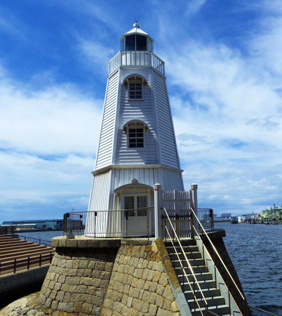
Sakai Light
1877 Sakai Lighthouse, Sakai, September 2012
Wikimedia Creative Commons photo by Hiroaki Kaneko
Misaki Town Lighthouses
* Fuke Kō West Breakwater
1969. Active; focal plane 12 m (39 ft); red light, 2 s on, 2 s off. 10 m (33 ft) round hourglass-shaped red concrete tower. Trabas has a photo, FOAL has photos, I. Awashi has a street view, and Google has a satellite view. Located at the end of the west breakwater of Fuke Kō, a small harbor at the southern end of Ōsaka Bay. Accessible by walking the pier. Site open, tower closed. ARLHS JPN-1907; JCG-3506; Admiralty M5958; NGA 7212.
* Fuke Kō East Breakwater
1966. Active; focal plane 13 m (43 ft); green light, 2 s on, 2 s off. 10 m (33 ft) round hourglass-shaped white concrete tower. Trabas has a photo, FOAL has photos, a 2022 photo is available, I. Awashi has a street view showing both breakwater lights, and Google has a satellite view. Located at the end of the east breakwater of Fuke Kō. Accessible by walking the pier. Site open, tower closed. ARLHS JPN-1906; JCG-3509; Admiralty M5958.2; NGA 7224.
* Tannowa Kō (2)
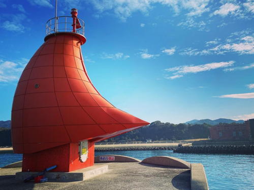
1997 (station established 1963). Active; focal plane 13 m (43 ft); continuous red light with a more intense flash every 5 s. 8.5 m (28 ft) square tapered concrete tower, surrounded by a "skirt" designed to resemble the sail of a yacht. Entire lighthouse is red. A photo is at right, Trabas has a photo, FOAL's page has photos, and Google has a street view and a satellite view. Tannowa is a well known sailing center and the "sail" was added to the light in 1997 to create a symbol for the town. Located at the end of the main breakwater of Tannowa harbor in Sennan. Accessible by walking the pier. Site open, tower closed. . ARLHS JPN-1930; JCG-3510; Admiralty M5957.83; NGA 7228.

Tannowa Kō Light, Sennan, February 2021
Instagram photo by yo_ko1679

Hannan City Lighthouse
Ozaki (Isomisaki) Kō Outer Breakwater
Date unknown. Active; focal plane 11 m (36 ft); red flash every 3 s. 8.5 m (28 ft) concrete post with gallery, rising from a square 1-story equipment room. Entire lighthouse is red. Trabas has a closeup photo and Google has a satellite view. Located at the end of the outer breakwater of Ozaki, a small port at the southern end of Ōsaka Bay. Site and tower closed. JCG-3510.71; Admiralty M5957.7; NGA 7230.6.

Izumisano City Lighthouses
Kanku (Kansai International Airport) North Breakwater
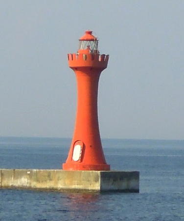
Date unknown. Active; focal plane 15 m (49 ft); red light, 2 s on, 2 s off. 13 m (43 ft) round hourglass-shaped concrete block tower with lantern and gallery. Entire lighthouse is red. The tower is floodlit at night. A photo is at right, Trabas has a closeup photo, a distant photo showing both breakwater lighthouses is available, and Google has a sea view and a satellite view. Ōsaka's airport, Kansai International, is built on an artificial island in Ōsaka Bay about 40 km (25 mi) south of the city. Most travelers arrive at the airport by monorail or express trains, but there is also a high speed ferry service that brings travelers across the bay from Kōbe (on the north). This lighthouse marks the entrance to the small ferry harbor, at the north end of the artificial island. Located at the end of the curved breakwater on the north side of the ferry harbor. Site and tower closed, but there must be excellent views from the ferries. ARLHS JPN-1913; JCG-3512.71; Admiralty M5957.59; ex-NGA 7238.
Kanku (Kansai International Airport) South Breakwater
Date unknown. Active; focal plane 12 m (39 ft); green light, 2 s on, 2 s off. 10 m (33 ft) round hourglass-shaped concrete block tower with lantern and gallery. Entire lighthouse is white. The tower is floodlit at night. Trabas has a closeup photo, a distant photo showing both breakwater lighthouses is available, and Google has a sea view and a satellite view. Located on the short south breakwater of the airport's ferry harbor. Site and tower closed, but there must be excellent views from the ferries. ARLHS JPN-1912; JCG-3512.7; Admiralty M5957.585; ex-NGA 7239.
* Izumisano (Hannan) Kō Outer Breakwater
2010. Active; focal plane 13 m (43 ft); two red flashes every 5 s. 8.5 m (28 ft) concrete post with gallery, rising from a square 1-story equipment room. Entire lighthouse is red. Trabas has a closeup photo, FOAL's page has photos (top half of the page), and Google has a satellite view. This light and the next one are listed as "Hannan Ko" lights by NGA. Located at the end of the outer breakwater of Izumisano, which is just east of Kansai International Airport. Accessible by walking the pier (which is very popular with fishermen). Site open, tower closed. JCG-3518.5; Admiralty M5957.52; NGA 7235.
* Sano Gyoko
1961. Active; focal plane 13 m (43 ft); green flash every 4 s. 8.5 m (28 ft) round concrete tower, flared at the top, attached to a small equipment shelter. Entire lighthouse is white. Trabas has a closeup photo, FOAL's page has photos (bottom half of the page), and Google has a satellite view. Located at the end of the north breakwater of a yacht harbor just north of the bridge to the airport. Accessible by walking the pier. Site open, tower closed. JCG-3518; Admiralty M5957.4; NGA 7236.

North Breakwater Light, Kansai International Airport, July 2012
Google Maps photo by Wa Wa
Izumisano (Hannan) Kō Detached (Offing) Breakwater
Date unknown. Active; focal plane 16 m (52 ft); two red flashes every 7 s. 16 m (52 ft) round cylindrical concrete tower with lantern and gallery. Entire lighthouse is red. Trabas has a good photo, a 2022 sunset photo is available, and Google has a street view and a satellite view. Located at the end of the detached outer breakwater of Izumisano. Accessible only by boat. Site and tower closed. JCG-3519; Admiralty M5957.2; NGA 7240.

Kishiwada City Lighthouses
Kishiwada is a seaport with a population of about 200,000 located about 20 km (13 mi) south of Ōsaka.

Hannan Kō North Breakwater
Date unknown. Active; focal plane 13 m (43 ft); red flash every 3 s. 9 m (29 ft) concrete post attached to a rectangular 1-story equipment shelter. Entire lighthouse is red. Trabas has a photo, FOAL has a photo (3/4 the way down the page, on the left), and Google has a satellite view. Located at the end of the main breakwater sheltering Hannan harbor. Site status unknown. ARLHS JPN-1909 (?); JCG-3521.55; Admiralty M5955.3; NGA 7242.
* Hannan Kō Offing Breakwater
Date unknown. Active; focal plane 13 m (43 ft); two green flashes every 6 s. 10 m (33 ft) round cylindrical white concrete tower. Trabas has a photo, FOAL has photos (top of the page), and Google has a satellite view. Located on a short inner breakwater of an industrial harbor at the southern edge of Kishiwada. Accessible by walking the pier. Site open, tower closed. ARLHS JPN-1911; JCG-3520; Admiralty M5956.2; NGA 7244.
Hannan Kō Outer (Detached) Breakwater South End
Date unknown. Active; focal plane 15 m (49 ft); green flash every 3 s. 11 m (36 ft) round white concrete tower, flared at the top, attached to a small equipment shelter. Trabas has a photo, FOAL has a photo (3/4 the way down the page, on the right), and Google has a satellite view. This breakwater was formerly detached but expansion of the port brought it in contact with the shore. Site status unknown. ARLHS JPN-1910; JCG-3521; Admiralty M5955.5; NGA 7248.
Kishiwada West Breakwater South End
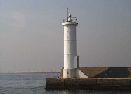
Date unknown. Active; focal plane 13 m (43 ft); green flash every 4 s. 11 m (36 ft) round white concrete tower. A photo is at right, Trabas has a photo, FOAL has a photo (halfway the way down the page), and Google has a satellite view. The breakwater is about 1.5 km (1 mi) long, protecting the Kishiwada waterfront. Located at the south end of the breakwater. Accessible only by boat. Site and tower closed. ARLHS JPN-1908; JCG-3525; Admiralty M5955.04; NGA 7264.
Kishiwada (West Breakwater North End)
Date unknown. Active; focal plane 16 m (52 ft); three red flashes every 13 s. 16 m (52 ft) round cylindrical concrete tower with lantern and gallery. Entire lighthouse is red. Trabas has a closeup photo, FOAL has a photo (3/4 the way down the page, on the right), and Google has a satellite view. Located at the north end of the detached west breakwater of Kishiwada. Accessible only by boat. Site and tower closed. ARLHS JPN-1914; JCG-3524; Admiralty M5955; NGA 7260.
Hannan Outer Breakwater Light
Kishiwada West Breakwater South End Light, Kishiwada
Japanese Coast Guard Region Five photo

Tadaoka Town Lighthouses
Senboku Wharf Northeast Corner
Date unknown. Active; focal plane 18 m (59 ft); red flash every 3 s. 16 m (52 ft) round cylindrical concrete tower with lantern and gallery. Entire lighthouse is red. Trabas has a closeup photo, FOAL has a photo (second row, right), and Google has a satellite view. Located at the northeast corner of a large new wharf area constructed on fill at Senboku, about 5 km (3 mi) north of Kishiwada. Site and tower closed. ARLHS JPN-1928; JCG-3529; Admiralty M5953.6; NGA 7272.
Senboku East Breakwater
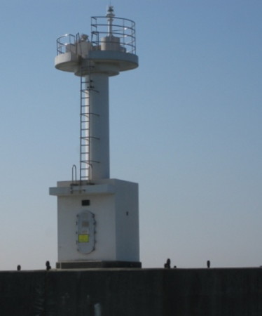
Date unknown. Active; focal plane 12 m (39 ft); green flash every 5 s. 8.5 m (28 ft) concrete post rising from a square concrete equipment room. Entire lighthouse is white. The Coast Guard has the photo at right, Trabas has a photo, FOAL has a photo (second row, left), and Google has a good satellite view. Located at the end of the east breakwater of Senboku. Site status unknown. JCG-3532; Admiralty M5953; NGA 7280.

Sakai City Lighthouses
Sakai is a historic seaport on the southern edge of Ōsaka. The city has a population of about 850,000.

Sakai Hamadera South Breakwater
Date unknown. Active; focal plane 18 m (59 ft); red light, 3 s on, 3 s off. 16 m (52 ft) round cylindrical concrete tower. Entire lighthouse is red. Trabas has a photo, FOAL has photos (bottom of the page), Yoasobi Kozou has a short video showing both Hamadera lighthouses, and Google has a satellite view. Located at the end of the short south breakwater at the entrance to the south harbor of Sakai, on the south side of Ōsaka. Site and tower closed. ARLHS JPN-1927; JCG-3552; Admiralty M5951; NGA 7288.
Sakai Hamadera North Breakwater
Date unknown. Active; focal plane 18 m (59 ft); red light, 3 s on, 3 s off. 14 m (46 ft) round cylindrical concrete tower with lantern and gallery. Entire lighthouse is white. Trabas has a closeup, FOAL has photos (bottom of the page), Yoasobi Kozou has a short video showing both Hamadera lighthouses, aand Google has a satellite view. Located at the end of the short north breakwater at the entrance to the south harbor of Sakai, on the south side of Ōsaka. Site and tower closed. ARLHS JPN-1926; JCG-3551; Admiralty M5950; NGA 7284.
* Sakai (relocated)
1877. Inactive since 1968 (a decorative light is displayed). 11 m (36 ft) hexagonal wood tower with lantern and gallery, painted white. Hiroaki Kaneko's photo is at the top of this page, Giles Thomas has a good closeup, Wikimedia has a photo, Motoharu Sumi has a 2009 photo, Trane DeVore has a photo, Forand has a historic postcard view, and Google has a street view and a satellite view. Sakai is justifiably proud of this lighthouse, built by the town government at a time when Japan had fewer than thirty Western-style lighthouses. Forand has a second postcard view that shows the lighthouse at the end of the city's long breakwater. In 2006 the historic lighthouse was restored and relocated to a new pier. The lighthouse reopened to the public in March 2007. Site open, tower status unknown. Located on the southern seawall of Sakai. .
Senboku East Breakwater Light
Senboku East Breakwater Lighthouse, Tadaoka
Japanese Coast Guard Ōsaka Office photo
Sakai Detached Breakwater South End
Date unknown. Active; focal plane 14 m (46 ft); green flash every 4 s. 10 m (33 ft) post rising from a square equipment shelter. Entire lighthouse is white. Trabas has a photo and Google has a satellite view. Located at the south end of a detached breakwater on the south side of the entrance to the north harbor of Sakai. Accessible only by boat. Site and tower closed. ARLHS JPN-1925; JCG-3554; Admiralty M5939.8; NGA 7292.
Sakai Detached Breakwater North End
Date unknown. Active; focal plane 22 m (72 ft); red light, 2 s on, 2 s off. 19 m (62 ft) round concrete tower with lantern and gallery. Entire lighthouse is red. Trabas has a photo, FOAL has distant views (top of the page), and Google has a satellite view. Located at the seaward end of a detached breakwater on the south side of the entrance to the north harbor of Sakai. Accessible only by boat. Site and tower closed. ARLHS JPN-1924; JCG-3555; Admiralty M5939.7; NGA 7296.

Ōsaka City Lighthouses
Located at the head of Ōsaka Bay, Ōsaka is Japan's third largest city with a population of about 2.7 million. The larger Keihanshin metropolitan region, including Kyōto and Kōbe, has a population of more than 19 million.
Ōsaka South Harbor North Breakwater
Date unknown. Active; focal plane 15 m (49 ft); green flash every 4 s. 12 m (39 ft) round white concrete tower with lantern and gallery. Trabas has a good photo, FOAL has photos (first and second rows, on the right), and Google has a good satellite view. Located at the end of a short breakwater at the southern end of the harbor, across from the Sakai waterfront. Site status unknown. ARLHS JPN-1922; JCG-3579; Admiralty M5940; NGA 7304.
Ōsaka South Harbor
Date unknown. Active; focal plane 12 m (39 ft); two green flashes every 6 s. 9.5 m (31 ft) concrete post rising from a 1-story concrete equipment shelter. Entire lighthouse is white. Trabas has a closeup, FOAL has a photo (third row, on the right), and Google has a good satellite view. Located at the end of a short breakwater at the entrance to one of basins of Ōsaka's south harbor. Site and tower closed. ARLHS JPN-1919; JCG-3580; Admiralty M5945; NGA 7308.
Gaiko South Breakwater
Date unknown. Active; focal plane 21 m (69 ft); two red flashes every 7 s. 19 m (62 ft) round concrete tower with lantern and gallery. Entire lighthouse painted red. S. Katsuragi's photo is at right, Trabas has Jim Smith's photo, FOAL has additional photos (fourth row right and next to last photo), and Google has a satellite view. Located at the end of the breakwater on the south side of the entrance to Ōsaka's south harbor. Site and tower closed. ARLHS JPN-1921; JCG-3582; Admiralty M5939.4; NGA 7316.
Gaiko North Breakwater
Date unknown. Active; focal plane 21 m (69 ft); two green flashes every 7 s. 19 m (62 ft) round concrete tower with lantern and gallery. Entire lighthouse painted white. Trabas has a photo, FOAL has additional photos (fourth row left and last photo), and Google has a good satellite view. Located at the end of the breakwater on the north side of the entrance to Ōsaka's south harbor. Site and tower closed. ARLHS JPN-1920; JCG-3581; Admiralty M5939; NGA 7312.
Ōsaka Main South Breakwater
Date unknown. Active; focal plane 19 m (62 ft); red light, 2 s on, 2 s off. 17 m (56 ft) round concrete tower with lantern and gallery. Entire lighthouse painted red. Trabas has a good photo, FOAL has a photo (second row, right), and Google has a satellite view. In 2010 the lighthouse was under restoration to correct a lean apparently caused by a failure in the underlying breakwater. Located on a short breakwater on the south side of the entrance to Ōsaka's traditional harbor. Site and tower closed. JCG-3589; Admiralty M5918.

Gaiko South Breakwater Light, Ōsaka, October 2022
Google Maps photo by S Katsuragi
Ōsaka Main North Breakwater
Date unknown. Active; focal plane 19 m (62 ft); white light, 2 s on, 2 s off. 17 m (56 ft) round concrete tower with lantern and gallery. Entire lighthouse painted white. Trabas has a good photo, FOAL has a photo (second row, left), and Google has a satellite view. Located on a short breakwater on the north side of the entrance to Ōsaka's traditional harbor. Site and tower closed. JCG-3588; Admiralty M5915.
Ōsaka (Radar Tower)
Date unknown. Active; focal plane 52 m (171 ft); white flash every 5 s. 50 m (164 ft) round cylindrical concrete tower with a round skeletal tower and two galleries supporting various equipment at the top. The equipment presumably includes harbor control radar. Entire lighthouse is unpainted gray concrete. Trabas has Jim Smith's photo of the lighthouse in action (also seen at right), Kenichiro Asai has a 2022 closeup, and Google has an excellent satellite view. This tower probably replaced a historic lighthouse located on the original shoreline of the area. Located at the southeast corner of a large artificial island being created between the north and south harbors of Ōsaka. Site and tower closed. ARLHS JPN-814; JCG-3602; Admiralty M5932; NGA 7348.
#Ōsaka North Harbor Entrance (1)
Date unknown. Replaced. This was a 9 m (29 ft) concrete post centered on a round 1-story concrete equipment shelter, mounted on a square concrete pier. Entire lighthouse is white. Trabas has a photo. In November 2018 the light was replaced by a 5 m (16 ft) white tower (focal plane 9 m (30 ft); continuous green light with a more intense flash every 3 s). Google has a satellite view. Located at a channel junction within the North Harbor. Accessible only by boat. Site status unknown. ARLHS JPN-1917. Current light: JCG-3600; Admiralty M5920; NGA 7344.
 

Main Light, Ōsaka
photo copyright Jim Smith; used by permission
 

Information available on lost lighthouses:

Notable faux lighthouses:

Adjoining pages: South: Northern Wakayama | West: Kōbe and Akashi

Return to the Lighthouse Directory index | Ratings key

Posted December 22, 2006. Checked and revised September 13, 2023. Lighthouses: 29. Site copyright 2023 Russ Rowlett and the University of North Carolina at Chapel Hill.