Lighthouses of Japan: Kōbe and Akashi

The nation of Japan, known in Japanese as Nihon or Nippon (日本), occupies an archipelago off the east coast of Asia. The four main islands are Hokkaidō in the north, Honshū (the largest) in the center, Shikoku in the south, and Kyūshū in the southwest. The country includes thousands of other islands of all sizes; among them the Ryūkyū (Nansei) Islands are a long chain extending to the southwest and including the large island of Okinawa, and the Nanpō Islands are another long chain extending south into the Pacific Ocean. Much of Japan is mountainous but the coastal regions are densely populated and urbanized; the country's population is about 126 million.

Japan is divided into 47 prefectures. Kōbe and Akashi are busy seaport cities on the southeastern coast of Hyōgo Prefecture. Southern Hyōgo faces south on the eastern end of the Seto Inland Sea (Seto Naikai), which separates the main islands of Honshū and Shikoku. It is a coast crowded with port facilities. These industrialized facilities continue westward through the city of Himeji, which is also in Hyōgo Prefecture. Since port areas are typically closed to casual visitors, information on the many harbor lights of the Hyōgo cities is rather scarce.

Hyōgo also includes the large island of Awaji, which nearly spans the Seto Inland Sea and comes very close to connecting Honshū and Shikoku. Lighthouses of Awaji Shima and of the Himeji Area are on separate pages. In addition, Hyōgo Prefecture also has a northern coast facing the Sea of Japan. Lighthouses of that coast are described on the Tottori and Tajima page.

In Japanese the word for a lighthouse is tōdai or toudai (灯台). The words saki and misaki are for capes and headlands, hana ("nose") is a promontory, hantō is a peninsula, shima (also spelled sima or jima) is an island, bae is a reef, iwa or shi is a rocky reef, amase or se is a shoal, wan is a bay, nada is a sound or basin, kaikyō is a strait, kawa is a river, and or minato is a harbor.

Lighthouses in Japan are operated and maintained by the Japanese Coast Guard's Maritime Safety Agency. Almost always there is at least one Coast Guard Section Office in each prefecture, often two. The lighthouses of Kōbe and Akashi are maintained by the Kōbe office.

ARLHS numbers are from the ARLHS World List of Lights. JCG numbers are the Japanese Coast Guard's light list numbers. Admiralty numbers are from volume M of the Admiralty List of Lights & Fog Signals. U.S. NGA List numbers are from Publication 112.
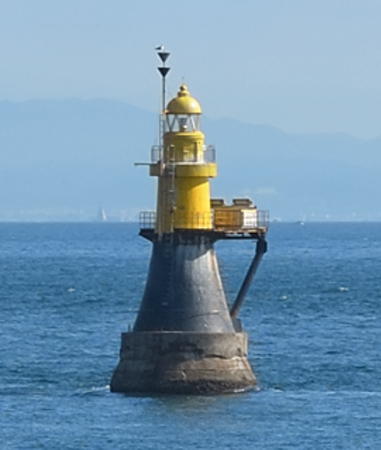

Hira Iso Light, Akashi Strait, November 2017
Google Maps photo by Plasma PKMN
General Sources
Lighthouses in Japan - Hyōgo
A site providing photos and data for most major Japanese lighthouses.
Lighthouse-Japan.com - Hyōgo
Another comprehensive site with photos and notes from visits to many lighthouses.
Form of a Lighthouse - Hyōgo
Another site with many photos of Japanese lighthouses and notes on how to find them; cited below as FOAL.
Misty's Japanese Lighthouse Tour - Hyōgo
Photos and a few notes for lighthouses in all parts of the country.
Online List of Lights - Japan
Photos by Alexander Trabas.
Lighthouses in Hyōgo Prefecture
Photos by various photographers available from Wikimedia.
Japan: Modern Lighthouses
Historic postcard views posted by Michel Forand.
Navionics Charts
Navigation chart for Hyōgo.

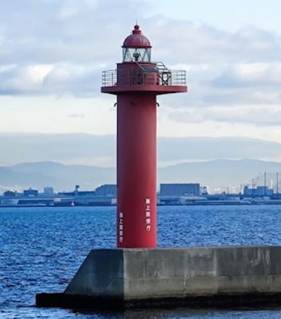
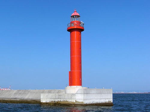
Breakwater Seven Southwest End Light, Nishinomiya, Kōbe, April 2019
Google Maps photo by wave big

Kōbe City Lighthouses

Located about 30 km (19 mi) west of Ōsaka, Kōbe is Japan's third-largest port city with a very busy harbor and a population of about 1.5 million. Much of the city has been rebuilt since the Great Hanshin earthquake of 17 January 1995.

Nishinomiya Lighthouses
Nishinomiya Breakwater Southeast End
Date unknown. Active; focal plane 16 m (52 ft); green flash every 5 s. 16 m (52 ft) round cylindrical concrete tower with lantern and gallery. Entire lighthouse is white. Trabas has a closeup photo and Google has a satellite view. The Nishinomiya Breakwater is a long east-west detached breakwater parallel to the coast between Ōsaka and Kōbe. Located at the east (Ōsaka) end of the breakwater, off the north harbor of Ōsaka. Accessible only by boat. Site and tower closed. JCG-3631; Admiralty M5899; NGA 7400.
* Ozekishuzo Imazu (Ozeki Saki)
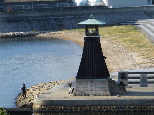
1810 (reconstructed or restored in 1858 and 1965; privately maintained). Active; focal plane 7.5 m (25 ft); continuous green light. 8 m (26 ft) square tapered wood tower with a open square "birdcage" lantern, mounted on a square stone base. Tower painted black. A photo is at right, FOAL's page has photos, S. Morita has a closeup photo, Trabas has a photo, K. Hirozawa has a 2021 closeup, a photo of the light in action is available, and Google has a street view and a satellite view. This historic lighthouse was rebuilt by the Osabe Brewing Company; it is the only pre-Meiji era lighthouse active in Japan. Although the light has only slight value for boaters it was accepted by the Coast Guard in 1968 and is carried on all the light lists as an official aid to navigation. In December 2023 the lighthouse was relocated 160 m (525 ft) to the opposite side of the harbor to make way for a floodgate and drainage pump station. Located at the entrance to a small boat harbor, part of an athletic complex in the Nishinomiya neighborhood at the eastern edge of Kōbe. Site open, tower closed. Owner/site manager: Ozeki Corporation. . ARLHS JPN-1527; JCG-3632; Admiralty M5886; NGA 7404.
Naruohama Breakwater
Date unknown. Active; focal plane 12 m (39 ft); two green flashes every 6 s. 9.5 m (31 ft) concrete post attached to a square 1-story concrete equipment room. Entire lighthouse is white. Trabas has a photo, FOAL has photos (fourth row and fifth row left), and Google has a satellite view. Located at the end of a narrow breakwater in the Naruohama harbor in eastern Kōbe. Site and tower closed. ARLHS JPN-1915; JCG-3631.2; Admiralty M5899.3; NGA 7402.
Nishinomiya North Breakwater
Date unknown. Active; focal plane 12 m (39 ft); green flash every 3 s. 10 m (33 ft) concrete post attached to a square 1-story concrete equipment room. Entire lighthouse is white. A closeup photo is available, Trabas also has a photo, FOAL has a photo (fifth row right), and Google has a satellite view. Located at the end of a long breakwater sheltering Nishinomiya harbor. Site status unknown. ARLHS JPN-1524; JCG-3631.6; Admiralty M5899.5; NGA 7398.

Ozekishuzo Imazu Light, Nishinomiya, Kōbe, October 2013
Wikipedia Creative Commons photo by Hirojin taja
Nishinomiya Breakwater West End
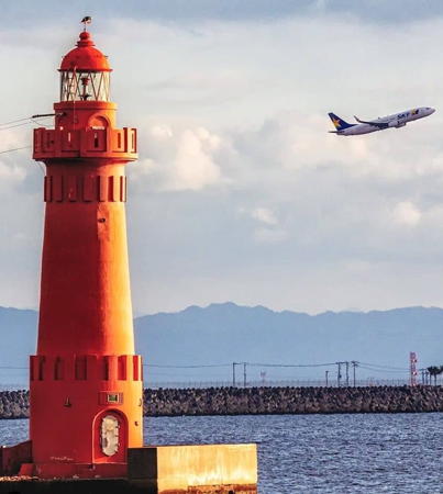
Date unknown. Active; focal plane 16 m (52 ft); red flash every 3 s. 17 m (56 ft) round cylindrical concrete tower with lantern and gallery. Entire lighthouse painted red. Kenichiro Asai's photo is at right, Trabas has a photo, FOAL has a photo (lower left on the page), Kazuo Arii has a nice view from the sea, and Google has a satellite view. The Nishinomiya Breakwater is a long east-west detached breakwater parallel to the coast between Ōsaka and Kōbe. Located at the west (Kōbe) end of the breakwater, marking the east side of the entrance to Kōbe. Accessible only by boat. Site and tower closed. ARLHS JPN-1523; JCG-3631.1; Admiralty M5899.2; NGA 7430.

Kōbe Harbor Lighthouses
Kōbe Kō (Breakwater Seven Northeast End)
Date unknown. Active; focal plane 20 m (66 ft); green flash every 3 s. 20 m (66 ft) round cylindrical concrete tower with lantern and gallery. Entire lighthouse is white. Trabas has a closeup photo, FOAL has a photo (lower right on the page), Kazuo Arii has a 2019 photo, and Google has a satellite view. Kōbe Breakwater Seven is an east-west detached breakwater parallel to the coast protecting the harbor of Kōbe. One of the main entrances to Kōbe harbor is between this breakwater and the Nishinomiya Breakwater to the east. Located at the east end of the breakwater. Accessible only by boat. Site and tower closed. ARLHS JPN-269; JCG-3647.5; Admiralty M5867.2; NGA 7428.
Kōbe Breakwater Seven Southwest End
Date unknown. Active; focal plane 19 m (62 ft); red flash every 3 s. 19 m (62 ft) round cylindrical concrete tower with lantern and gallery. Entire lighthouse is red. A 2019 photo is at the top of this page,Trabas has a closeup photo, FOAL has photos (fifth and sixth rows, left), Isao Kaihata has a distant view, and Google has a satellite view. Located at the western end of Kōbe Breakwater Seven, which bends sharply southwestward to be parallel to the entrance channel. Accessible only by boat. Site and tower closed. ARLHS JPN-1511; JCG-3647; Admiralty M5867; NGA 7424.
#Kōbe Breakwater Six South End
Date unknown. Demolished in 2013. This was a 19 m (62 ft) round cylindrical concrete tower with lantern and gallery. Entire lighthouse was white. No photo available; Google has a satellite view of the former location. Kōbe Breakwater Six is in two sections, one projecting eastward from Ohashi island and this one detached and directed southeastward parallel to the entrance channel. Formerly located at the southeast end of the detached section, opposite the Breakwater Seven Southwest End lighthouse; the lighthouse was removed when this section was shortened in 2013. A small beacon (focal plane 7 m (23 ft); yellow flash every 3 s) marks the shortened breakwater. Accessible only by boat. Site and tower closed. ARLHS JPN-1510. Active light: JCG-3646; Admiralty M5866.3; NGA 7420.

Nishinomiya Breakwater West End Light, Nishinomiya, Kōbe, January 2023
Google Maps photo by Kenichiro Asai
Kōbe Breakwater Six East End
Date unknown. Active; focal plane 18 m (59 ft); green flash every 3 s. 19 m (62 ft) round cylindrical concrete tower with lantern and gallery. Entire lighthouse is white. Trabas has a photo, FOAL has photos (fifth and sixth rows, right), a 2019 photo is available, and Google has a satellite view. Kōbe Breakwater Six is in two sections, one projecting eastward from Ohashi island and this one detached and directed southeastward parallel to the entrance channel. Located at the east end of the attached section, opposite the Breakwater Seven Southwest End lighthouse. Site and tower closed. ARLHS JPN-1509; JCG-3645; Admiralty M5866; NGA 7416.
Kōbe Breakwater Five
Date unknown. Active; focal plane 16 m (52 ft); green flash every 5 s. 16 m (52 ft) round cylindrical concrete tower with lantern and gallery. Entire lighthouse is white. Trabas has a photo, FOAL has photos (bottom of the page), a 2019 photo is available, and Google has a satellite view. Kōbe Breakwater Five is a detached breakwater that originally protected the Kōbe waterfront; now it is deep in the inner harbor, surrounded by artificial islands. Located at the east end of the breakwater. Accessible only by boat. Site and tower closed. JCG-3650; Admiralty M5870; NGA 7436.
#Kōbe Breakwater Four (1)
Date unknown. Replaced. The original lighthouse, a 15 m (49 ft) concrete post centered on a square concrete equipment shelter, has been replaced by a small square cabinet (focal plane 4 m (13 ft); red flash every 3 s). Entire lighthouse is red. FOAL has a photo (near the bottom of the page), and Google has a satellite view. Trabas has a photo of the new light. Located on the south side of an opening in the breakwater, about 300 m (1000 ft) off the Mayafuto Quay of Kōbe harbor. Accessible only by boat. Site and tower closed. ARLHS JPN-1508. Current light: JCG-3659; Admiralty M5872; NGA 7448.
Kōbe Breakwater Three
1935. Active; focal plane 17 m (56 ft); two green flashes every 7 s. 19 m (62 ft) round concrete tower with lantern and gallery. Entire lighthouse is white. Trabas has a great photo, a 2020 closeup is available, FOAL has photos (top of the page), and Google has a street view and a satellite view. Kōbe Breakwater Three is a short detached breakwater near the northeastern corner of Ohashi island. At an earlier time this lighthouse probably marked the entrance to the inner harbor of Kōbe. Located at the east end of the breakwater. Accessible only by boat. Site and tower closed. ARLHS JPN-1507; JCG-3661; Admiralty M5868; NGA 7452.
* Kōbe Breakwater Two
1930s (?). Active; focal plane 18 m (59 ft); red light, 6 s on, 2 s off. 19 m (62 ft) round concrete tower with lantern and gallery. Entire lighthouse is red. The lighthouse has unusual architectural details seen in the Coast Guard's photo at right. Trabas has a good photo, Nicki Kaoru has a photo, another photo and a 2007 photo are available, FOAL has photos (top photo and second row left), and Google has a satellite view. This lighthouse and the next two mark the older entrance to Kōbe harbor on the west side of Osashi island. Located at the end of the breakwater, a short pier at the southwestern corner of Osashi island. This lighthouse appears to be accessible by walking the pier. Site open, tower closed. . ARLHS JPN-1506; JCG-3664; Admiralty M5862; NGA 7456.

Kōbe Breakwater Two Light, Kōbe, January 2020
Instagram photo by Japan Lighthouse Club
Kōbe Breakwater One South End
Date unknown. Active; focal plane 18 m (59 ft); green light, 2 s on, 2 s off. 19 m (62 ft) round hourglass-shaped concrete tower with lantern and gallery. Entire lighthouse painted white. Diana Grande has a photo, Trabas has a closeup photo, FOAL has a photo (second row right), a 2022 photo and a 2017 photo are available, the lighthouse is in the background of a photo of the Breakwater Two Light, and Google has a satellite view. Kōbe Breakwater One is in two sections, both detached. Located at the south end of the southern section of the breakwater, which is directed southeastward parallel to the entrance channel. Accessible only by boat. Site and tower closed. JCG-3665; Admiralty M5861; NGA 7460.
Kōbe Breakwater One East End
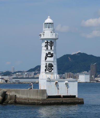
1931. Active; focal plane 19 m (62 ft); green light, 6 s on, 2 s off. 19 m (62 ft) round concrete tower with lantern and gallery. Entire lighthouse painted white; there are three large Japanese characters painted in black on the seaward side; the inscription is a blessing for the port, to protect it against typhoons. A photo is at right, Trabas has a good photo, Yoshiyuki Hamano has a 2022 photo, Kentaru Suda has a 2008 photo, Nicki Kaoru also has a photo, FOAL has a photo (third row), and Google has a satellite view. Sibling of the Breakwater Two Light (see above). Kōbe Breakwater One is in two sections, both detached. Located at the east end of the northern section of the breakwater, which is directed east to west. Accessible only by boat. Site and tower closed. ARLHS JPN-1504; JCG-3666; Admiralty M5860; NGA 7464.
* Naka (Meriken Park Oriental Hotel)
1995. Active (privately maintained); focal plane 54 m (177 ft); flash every 5 s, alternately red and green. 5 m (16 ft) hexagonal skeletal tower with lantern, mounted atop a 16-story hotel building. FOAL's page has good photos, Trabas has a closeup of the lantern, Sho Gentaro has a sea view, and Google has a satellite view. Located on a pier in the inner harbor area north of the Breakwater One lights. Site open, tower closed. Site manager: Kobe Meriken Park Oriental Hotel. ARLHS JPN-1520; JCG-3633; Admiralty M5854; NGA 7408.

Wadamisaki Lighthouses
Kōbe Breakwater One West End
Date unknown. Active; focal plane 13 m (43 ft); red light, 3 s on, 3 s off. 11 m (36 ft) round cylindrical concrete tower with a flared top. Entire lighthouse is red. Akashi Tako has a 2017 photo, Mariko Matsumoto has a 2018 photo, Trabas has a closeup photo, FOAL has photos (bottom of the page), and Google has a satellite view. Located at the west end of the detached Breakwater One, marking the entrance to Wadamisaki harbor on the west side of Kōbe. Accessible only by boat. Site open, tower closed. ARLHS JPN-1505; JCG-3667; Admiralty M5857.5; NGA 7472.5.

Kōbe Breakwater One East End Light, Kōbe, August 2017
Google Maps photo by akashitako
Wadamisaki (Wada) Breakwater
Date unknown. Active; focal plane 12 m (39 ft); green light, 3 s on, 3 s off. 11 m (36 ft) round cylindrical concrete tower. Entire lighthouse is white. Nicki Kaoru has a photo, Trabas has a photo, another photo is available, and Google has a satellite view. Located on a short breakwater on the west side of the entrance to Wadamisaki harbor. Site status unknown. ARLHS JPN-1544; JCG-3668; Admiralty M5857; NGA 7472.
Kōbe
1884. Active; focal plane 26 m (85 ft); white flash every 8 s. 29 m (95 ft) round concrete tower with lantern and gallery, painted white. FOAL has a page with photos, Trabas has a photo, Nikaido Shinku has a closeup, and Google has a satellite view. Located in an industrial area a short distance west of Wadamisaki. Site and tower closed, but the lighthouse can be seen from outside a fence. ARLHS JPN-268; JCG-3669; Admiralty M5852; NGA 7476.

Nagata, Suma, and Tarumi Lighthouses
Nagata Kō
Date unknown. Active; focal plane 12 m (39 ft); green light, 2 s on, 2 s off. 11 m (36 ft) round cylindrical concrete tower. Entire lighthouse is white. Trabas has a photo and Google has a satellite view. Located on the breakwater on the west side of the entrance to Nagata harbor, an industrial basin. ARLHS JPN-1519; JCG-3672; Admiralty M5844; NGA 7488.
Suma Breakwater East Head
Date unknown. Active; focal plane 10 m (33 ft); green flash every 3 s. 8.5 m (28 ft) round hourglass-shaped white concrete tower. Trabas has a closeup photo and Google has a satellite view and a very distant street view. Located at the east end of a detached breakwater protecting the small boat harbor of Suma ward. Accessible only by boat. Site open, tower closed. ARLHS JPN-1537; JCG-3673; Admiralty M5843; NGA 7492.
* Wada Misaki (Wadamisaki) (2) (relocated)
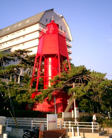
1884 (station established 1871). Inactive since 1963. 16 m (52 ft) hexagonal cast iron pyramidal tower with lantern, gallery, enclosed watch room, central cylinder, and a hexagonal wood keeper's cottage at the base. Lighthouse painted red with white trim. Tomo Marusan's photo is at right, Lighthouses of Japan has a photo (bottom of the page), a 2007 photo is available, Hisatomo Tatsuki has a street view, and Google has a street view and a satellite view. Forand has a postcard view of the lighthouse in service. This historic lighthouse, one of the oldest surviving iron lighthouses in Japan, was built on Wada Misaki, the point of land at the west end of Kōbe harbor; it replaced a wood lighthouse designed by Richard Henry Brunton. In 1964 it was relocated as a historic monument to the Suma Seaside Park, about 800 m (1/2 mi) west of the aquarium and 6 km (4 mi) west of the original location. Site open, tower closed. . ARLHS JPN-263M.
Wada Misaki Light
Wada Misaki Light, Suma, Kōbe, March 2006
Wikimedia Creative Commons photo by Tomo Marusan
** Suma (Outer Suma Tower)
Date unknown. Active (privately maintained); focal plane 19 m (62 ft); three white flashes, two short and one long, every 15 s. 19 m (62 ft) round observation building supported by pilings. The building is white. Trabas has a closeup photo, Tetsuo Suzuki has a view from the shore, and Google has a satellite view and a distant street view. This popular tower is built over a complex of public fishing piers. Located in Suma, a ward on the west side of Kōbe. Site and tower open. ex-JCG-3674; Admiralty M5842.4; NGA 7496.
Hira Iso
1893. Active; focal plane 14 m (46 ft); six quick white flashes followed by one long white flash, every 15 s. 15 m (49 ft) round tower with lantern and double gallery, mounted on a solid conical base. Tower painted yellow, conical base painted black. A photo is at the top of this page, Trabas has a closeup photo, Lighthouse-Japan.com has a page with photos, FOAL has a photo (bottom of the page), a 2017 photo is available, Forand has a historic postcard view, Masutaka Mori has a distant street view from shore, and Bing has a satellite view. This historic lighthouse is one of the oldest Japanese waveswept towers. The lighthouse marks a dangerous shoal in the eastern approach to the Akashi Strait, which separates the island of Awaji Shima from the mainland of Honshū. Located about 500 m (0.3 mi) offshore from Tarumi Ward, at the western edge of Kōbe City. Accessible only by boat, but there are good views from shore. Site and tower closed. ARLHS JPN-782; JCG-3675; Admiralty M5840; NGA 7500.
Tarumi Kō (South Breakwater East End)
Date unknown. Active; focal plane 13 m (43 ft); green flash every 3 s. 12 m (39 ft) round concrete tower, flared at the top and attached to a small equipment shelter. Entire lighthouse is white. Trabas has a closeup photo, a 2023 photo is available, and Google has a distant street view and a satellite view. Located at the east end of the detached breakwater protecting Tarumi harbor, about 3 km (2 mi) east of the Akashi Kaikyō Bridge. Accessible only by boat. Site open, tower closed. ARLHS JPN-1543; JCG-3678; Admiralty M5838.6; NGA 7504.

Akashi City Lighthouses

Akashi is a waterfront city of about 300,000 residents on the west side of Kōbe, its docks extending the Kōbe port area.

Akashi Harbor Lighthouses
* Akashi (Akasi) South Breakwater
Date unknown. Active; focal plane 11 m (36 ft); red light, 3 s on, 3 s off. 9 m (30 ft) round hourglass-shaped concrete tower. Entire lighthouse is red. David Jackson has a photo, Trabas has a photo, FOAL has photos (second and third rows, left), and Google has a street view and a satellite view. Located at the end of the main east breakwater at Akashi, about 4 km (2.5 mi) west of the Akashi Kaikyō Bridge. Accessible by walking the pier. Site open, tower closed. JCG-3822; Admiralty M5783; NGA 7652.
* Akashi (Akasi) Old Harbor (Kyūnami Kanzaki Tōrōdō)
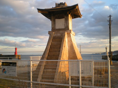
1657. Inactive since 1963. Approx. 7 m (23 ft) square pyramidal stone tower with a square stone lantern. Wikimedia has many photos including K. Comiida's photo at right, Forand has a historic postcard view, FOAL has photos (first row and third row, right), a 2023 photo and a 2019 closeup is available, and Google has a street view and a satellite view. This well preserved example of a traditional Japanese harbor lighthouse is thought to be the oldest such tower surviving. Modern lighting equipment was installed in 1873. The lighthouse was restored in 1953 but deactivated in 1963 when expansion of the port made its light redundant. The Coast Guard transferred ownership to the city in 1999 and the lighthouse was registered as a national cultural landmark in 2014. Located at the base of the Akashi west breakwater. Site open, tower closed. Owner/site manager: City of Akashi. .
Akashi (Akasi) Outer Harbor West Breakwater
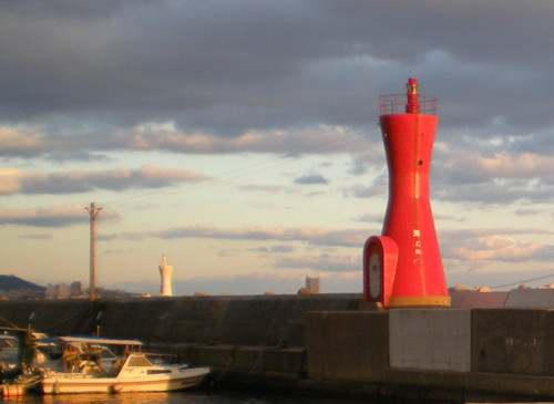
Date unknown. Active; focal plane 13 m (43 ft); green light, 3 s on, 3 s off. 9 m (30 ft) round hourglass-shaped concrete tower. Entire lighthouse is white. FOAL has photos (first, third and fourth rows), the light is at the left in K. Comiida's photo (below right), Trabas has a photo, and Google has a street view and a satellite view. Located on the west mole at the entrance to the main harbor of Akashi. Site and tower closed. JCG-3823; Admiralty M5785; NGA 7656.

Akashi Old Harbor Light, Akashi, January 2008
Wikimedia Creative Commons photo by K. Comiida
Akashi (Akasi) (East Breakwater)
Date unknown. Active; focal plane 11 m (36 ft); red light, 3 s on, 3 s off. 9 m (30 ft) round hourglass-shaped concrete tower. Entire lighthouse is red. K. Comiida's photo is at right, FOAL has photos (rows 5, 6, and 7), Trabas has a photo, Google has a street view and a satellite view. Located at the end of the original east breakwater at Akashi. Accessible by walking the pier. Site status unknown. ARLHS JPN-012; JCG-3824; Admiralty M5784; NGA 7660.
Akashi Kō West Breakwater
Date unknown. Active; focal plane 13 m (43 ft); two green flashes every 6 s. 8.5 m (29 ft) round hourglass-shaped concrete tower. Entire lighthouse is white. Trabas has a closeup photo, FOAL has photos (bottom of the page), and Google has a street view and a satellite view. Located on the west mole at the entrance to the main harbor of Akashi. Site and tower closed. ARLHS JPN-1483; JCG-3825; Admiralty M5782.6; NGA 7664.
Akashi Kō West Outer Breakwater
1970. Active; focal plane 12 m (39 ft); green light, 3 s on, 3 s off. 10 m (33 ft) concrete post centered on a square 1-story concrete equipment room. Entire lighthouse is white. The second light seen in the photo is the West Breakwater light (previous entry). Trabas has a closeup photo, FOAL has photos (bottom of the page), and Google has a street view and a satellite view. Located actually on the east end of the west outer breakwater of Akashi. Site and tower closed. ARLHS JPN-1485; JCG-3824.5; Admiralty M5782.8; NGA 7666.
* Eigishima (Eigashima) Kō
Date unknown. Active; focal plane 13 m (43 ft); continuous green light with a more intense flash every 7 s. 10 m (33 ft) concrete post attached to a square 1-story concrete equipment room. Entire lighthouse is white. Trabas has a closeup photo, a 2023 photo is available, and Google has a distant street view as well as a satellite view. Located at the end of the west (main) breakwater of Eigishima, a small boat harbor on the west side of Akashi. Accessible by walking the pier. Site open, tower closed. ARLHS JPN-1489; JCG-3830; Admiralty M5781; NGA 7672.
Akashi Kō Light
Akashi Kō Light, Akashi, January 2008
ex-Panoramio Creative Commons photo by K. Comiida

Information available on lost lighthouses:

Notable faux lighthouses:

Adjoining pages: East: Ōsaka | South: Awaji Shima | West: Himeji Area

Return to the Lighthouse Directory index | Ratings key

Posted December 22, 2006. Checked and revised September 19, 2023. Lighthouses: 32. Site copyright 2023 Russ Rowlett and the University of North Carolina at Chapel Hill.