Lighthouses of Japan: Eastern Yamaguchi

The nation of Japan, known in Japanese as Nihon or Nippon (日本), occupies an archipelago off the east coast of Asia. The four main islands are Hokkaidō in the north, Honshū (the largest) in the center, Shikoku in the south, and Kyūshū in the southwest. The country includes thousands of other islands of all sizes; among them the Ryūkyū (Nansei) Islands are a long chain extending to the southwest and including the large island of Okinawa, and the Nanpō Islands are another long chain extending south into the Pacific Ocean. Much of Japan is mountainous but the coastal regions are densely populated and urbanized; the country's population is about 126 million.

Japan is divided into 47 prefectures. This page lists lighthouses on the southeastern coast of Yamaguchi Prefecture, located at the extreme southwestern tip of the main island of Honshū. Yamaguchi has coasts facing south on the Seto Inland Sea (Seto Naikai) and west and northwest on the Sea of Japan. The narrow, twisting Kanmon Strait connects these two seas and barely separates Honshū from Kyūshū. The principal ports in Yamaguchi are Tokuyama on the Inland Sea, Shimonoseki on the Kanmon Strait, and Nagato on the Sea of Japan.

Because of its lengthy coastline, Yamaguchi Prefecture has an unusually large number of lighthouses. This page lists lighthouses of the Seto Inland Sea coast; the Western Yamaguchi page has lighthouses of the Kanmon Strait and Sea of Japan.

In Japanese the word for a lighthouse is tōdai or toudai (灯台). The words saki and misaki are for capes and headlands, hana ("nose") is a promontory, hantō is a peninsula, shima (also spelled sima or jima) is an island, bae is a reef, iwa or shi is a rocky reef, amase or se is a shoal, wan is a bay, nada is a sound or basin, kaikyō is a strait, kawa is a river, and or minato is a harbor.

Lighthouses in Japan are operated and maintained by the Japanese Coast Guard's Maritime Safety Agency. On Honshū there is generally at least one Coast Guard Section Office in each prefecture, often two or more. The situation in Yamaguchi is more complicated. The extreme southeastern portion of the prefecture is under the jurisdiction of the Hiroshima Office in neighboring Hiroshima Prefecture, while the remaining lights on this page are maintained by the Tokuyama Office in the city of Shūnan.

A note on the Sea of Japan/East Sea controversy: The Directory takes no side in any international dispute; it makes use of the terminology, names, and spellings as they currently exist in each area covered. The sea between Japan and Korea is called the Sea of Japan on the pages for Japan and the East Sea on the pages for Korea.

ARLHS numbers are from the ARLHS World List of Lights. JCG numbers are the Japanese Coast Guard's light list numbers. Admiralty numbers are from volume M of the Admiralty List of Lights & Fog Signals. U.S. NGA List numbers are from Publication 112.

General Sources:
Lighthouses in Japan - Yamaguchi
A site providing photos and data for most major Japanese lighthouses.
Lighthouse-Japan.com - Yamaguchi
Another comprehensive site with photos and notes from visits to many lighthouses.
Form of a Lighthouse - Yamaguchi
A large and growing web site, but only a few Yamaguchi prefecture lights are included as yet.
Lighthouse Visit
Another comprehenisve site with photos of most Yamaguchi lighthouses.
Misty's Japanese Lighthouse Tour - Yamaguchi
Photos and a few notes for lighthouses in all parts of the country.
Japanese Lighthouse/Cape Index
Photos of many Japanese lighthouses (identified by JCG number) are linked to this page.
Online List of Lights - Japan
Photos by various photographers posted by Alexander Trabas. Some of the photos from this area are by Michael Boucher.
Lighthouses in Yamaguchi Prefecture
Photos by various photographers available from Wikimedia.
Japan: Modern Lighthouses
Historic postcard views posted by Michel Forand.
Navionics Charts
Navigation chart for the western Inland Sea.
Kuka Ko Light
Kuka Kō Light, Suō-Ōshima
Japanese Coast Guard Hiroshima Office photo
Hiroshima Coast Guard District Lighthouses

Iwakuni City Lighthouse
Iwakuni is a large industrial city on the west side of Hiroshima Bay. Americans may be familiar with it as the site of the Iwakuni Marine Corps Air Station.

Hashira Shima (Hashirajima) East Breakwater
Date unknown. Active; focal plane 16 m (52 ft); green light, 2 s on, 2 s off. 10 m (33 ft) round cylindrical concrete tower. Entire lighthouse is white. Trabas has Boucher's photo, a 2015 photo is available and Google has a satellite view. Hashira is a small island in the center of Hiroshima Bay, accessible by passenger ferry from the Iwakuni waterfront. Located at the end of the main breakwater of Hashira Shima. Site status unknown. JCG-4709; Admiralty M5662; NGA 8920.

Suō-Ōshima Town Lighthouses
The municipality of Suō-Ōshima occupies the island of Yashiro Shima at the south end of Hiroshima Bay. One of the largest islands of the Inland Sea, Yashiro Shima is about 30 km (19 mi) in length. It is accessible from the mainland by the Ōshima Bridge, built in 1976 across a strait having one of the fastest and most dangerous tidal currents in Japan.
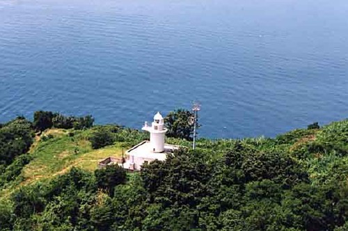
* Kuka Kō
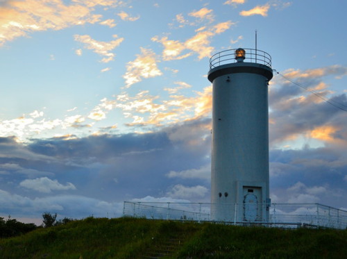
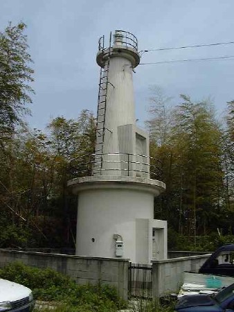
1971. Active; focal plane 36 m (118 ft); two white flashes every 8 s. 11 m (36 ft) round concrete tower with gallery, centered on a round 1-story concrete equipment room. Entire lighthouse is white. There is a keeper's house nearby. A photo is at the top of this page, Trabas has a closeup photo, Lighthouse-Japan.com has a page with several photos, Lighthouse Visit also has a page with photos, and Google has a street view and a satellite view. Kuka is a port on the north side of Yashiro Shima. Located on a promontory northeast of the waterfront of Kuka. Accessible by road but parking is limited. Site open, tower closed. ARLHS JPN-297; JCG-4795; Admiralty M5658; NGA 9100.
Ihota Kō
1981. Active; focal plane 13 m (43 ft); red flash every 4 s. 10 m (33 ft) round cylindrical fiberglass tower. Entire lighthouse is red. Trabas has a closeup photo, Lighthouse Visit has photos (bottom of the page), and Google has a street view, a sea view, and a satellite view. Located at the end of a detached breakwater at Ihota, near the easternmost tip of the island of Yashiro Shima. Accessible only by boat. Site open, tower closed. JCG-4797; Admiralty M5657; NGA 9108.
Nasake Shima
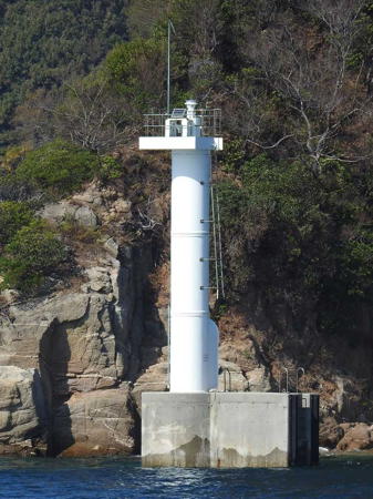
Date unknown. Active; focal plane 12 m (39 ft); white flash every 3 s. 9.5 m (31 ft) round white concrete post centered on a hexagonal concrete pier. Trabas has Boucher's photo (also seen at right), Ryuta Takezaki has a 2022 view from the sea, and Google has a satellite view. Located on the southern tip of Nasake Shima, marking the 500 m (0.3 mi) wide strait between that island and the northeastern tip of Yashiro Shima. Accessible only by boat. Site open, tower closed. JCG-4929.4; Admiralty M5646.3; NGA 9190.
Oishi (Oisi)
Date unknown. Active; focal plane 13 m (43 ft); one long and two short green flashes every 8 s. 10 m (33 ft) round concrete tower, mounted on a round concrete pier. Entire lighthouse is green. Trabas has a photo, a 2021 closeup is available, and Google has a satellite view. Located on a reef off the southeastern tip of Yashiro Shima. Accessible only by boat. Site open, tower closed. JCG-4930; Admiralty M5645.4; NGA 9192.
Kominase Shima (2)
1968 (heightened in 1991) (station established 1927). Active; focal plane 20 m (66 ft); white flash every 4 s. 15 m (49 ft) 2-stage round cylindrical concrete tower with two galleries on the lower stage; the upper stage is a slender concrete post. Entire lighthouse is white. Takashi Saiki has a 2019 photo, Lighthouse Visit has a page with a distant photo and Google has a satellite view. The original light was on a skeletal tower. In 1991 the lantern of the present tower was removed and replaced by the upper stage. Located on the southeastern tip of a small island about 8 km (5 mi) south of the southeastern corner of Yashiro Shima. Accessible only by boat. Site status unknown. ARLHS JPN-1628; JCG-4916; Admiralty M5644; NGA 9148.

Nasake Shima Light, Suō-Ōshima
photo copyright Michael Boucher; used by permission
Okikamuro Shima Naga Se
Date unknown. Active; focal plane 15 m (49 ft); four green flashes (long-short-long-short) every 13 s. 11 m (36 ft) round concrete tower, mounted on a round concrete pier. Entire lighthouse is green. Trabas has a photo, Kenichiro Asai has a 2022 photo, Lighthouse Visit has photos (halfway down the page), and Google has a satellite view. Located on a reef just off the southern tip of Okikamuro Shima, a small island off the south coast of Yashiro Shima. Accessible only by boat. Site open, tower closed. JCG-4934; Admiralty M5641; NGA 9202.
* Agenosho Kō (Agenosyoko)
1964. Active; focal plane 11 m (36 ft); continuous red light with a more intense flash every 5 s. 8.5 m (28 ft) concrete post attached to a square 1-story concrete equipment room. Entire structure covered with red tile. Trabas has a closeup photo and Google has a street view and a satellite view. Located at a breakwater of Agenosho Kō, a port on the south side of Yashiro Shima. Accessible by walking the pier. Site open, tower closed. ARLHS JPN-1603; JCG-4937; Admiralty M5639; NGA 9212.
Shimo-Ninai (Simo-Ninai) Shima
1937. Active; focal plane 118 m (387 ft); four white flashes every 14 s. 12 m (39 ft) round cylindrical concrete tower with lantern and gallery, rising from the front of a semicircular 1-story concrete keeper's house. Entire lighthouse is white. Trabas has a photo and Google has a satellite view. Located on the summit of a small island in the south entrance to the channel between Yashiro Shima and the mainland, about 15 km (9 mi) south southeast of Yanai. Accessible only by boat. Site status unknown. ARLHS JPN-1657; JCG-4938; Admiralty M5628; NGA 9216.
O Iso
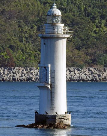
1937. Active; focal plane 14 m (46 ft); white flash every 3 s. 16 m (52 ft) round concrete tower with lantern and gallery, painted white. A Coast Guard photo appears at right, Trabas has Boucher's photo (also seen at right), Kenichiro Asai has a 2023 photo, and Google has a satellite view and a distant sea view. The lighthouse was originally painted with red and black horizontal bands, but according to the Coast Guard it has been all white since 1986. The lighthouse stands on a dangerous rock in the narrow channel between Yashiro Shima and the mainland. Located about 2.5 km (1.5 mi) west of the Oshima Bridge. Accessible only by boat. Site and tower closed. ARLHS JPN-1647; JCG-4799; Admiralty M5636; NGA 9112.

O Iso Light, Suō-Ōshima
photo copyright Michael Boucher; used by permission

Yanai City Lighthouses
Yanai Kō (Outer Breakwater)
Date unknown. Active; focal plane 13 m (43 ft); two red flashes every 6 s. 9 m (30 ft) concrete post attached to a square 1-story concrete equipment shelter. Entire lighthouse is red. Trabas has Boucher's closeup photo and Google has a distant street view, a sea view, and a satellite view. Located at the west end of a detached breakwater off Yanai harbor. Accessible only by boat. Site open, tower closed. ARLHS JPN-1675; JCG-4801.5; Admiralty M5634.5; NGA 9116.
Yanai Kō East Breakwater
Date unknown. Active; focal plane 11 m (36 ft); two green flashes every 6 s. 8.5 m (28 ft) concrete post attached to a square 1-story concrete equipment shelter. Entire lighthouse is white. Trabas has Boucher's photo and Google has a sea view and a satellite view. Located on a detached breakwater opposite the Outer Breakwater light (previous entry). Accessible only by boat. Site open, tower closed. ARLHS JPN-1676; JCG-4802; Admiralty M5632; NGA 9120.
Yanai Kō West Breakwater
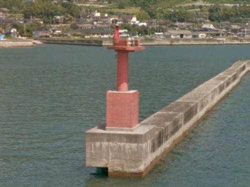
Date unknown. Active; focal plane 12 m (39 ft); red flash every 3 s. 8.5 m (28 ft) concrete post attached to a square 1-story concrete equipment shelter. Entire lighthouse is red. Trabas has a photo and Google has the sea view seen at right and a satellite view. Located on a detached breakwater at the west entrance to Yanai harbor. Accessible only by boat. Site open, tower closed. ARLHS JPN-1677; JCG-4803; Admiralty M5634; NGA 9124.

West Breakwater Light, Yanai, September 2016
Google Maps sea view

Tokuyama Coast Guard District Lighthouses

Kaminoseki Town Lighthouses
Ya Shima
Date unknown (station established 1909). Active; focal plane 61 m (200 ft); white flash every 10 s. 11.5 m (37 ft) round concrete tower with lantern and gallery. Entire lighthouse is white. A Coast Guard photo appears at right, Yumi Nosuke has a closeup photo, and Google has a satellite view. This is an important light, since Ya Shima is the southernmost island of the Bōyo (Hōyo) Islands, the group that includes Suō-Ōshima. East-west ship traffic in the Inland Sea must round this point to continue in either direction. Located on a steep slope at the southern end of the island, a location that appears difficult to access. Site and tower closed. ARLHS JPN-742; JCG-4918; Admiralty M5414; NGA 9160.
Hojiro (Hoziro) Shima
Date unknown. Active; focal plane 39 m (128 ft); white flash every 3 s. 7 m (23 ft) concrete post attached to a square 1-story concrete equipment room. A drone view and a view from the sea are available and Google has a satellite view. Located atop an islet about 11 km (6.5 mi) west of the Ya Shima lighthouse. Accessible only by boat. Site status unknown. ARLHS JPN-135; JCG-4919; Admiralty M5412; NGA 9164.
Kaijikake (Kazekaki) Iwa
Date unknown. Active; focal plane 13 m (43 ft); one short and one long green flash every 8 s. 11 m (36 ft) round concrete tower, flared strongly at the top and mounted on a round concrete pier. Entire lighthouse is green. Trabas has a photo, Kenichiro Asai has a 2023 photo, and Google has a satellite view. Located on a rock off the southeastern tip of the Kumage peninsula. Accessible only by boat. Site open, tower closed. JCG-4939; Admiralty M5627; NGA 9220.

Ya Shima Light, Suō-Ōshima
Japanese Coast Guard photo
* Murotsu (Murotu)
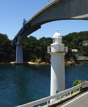
1936. Active; focal plane 15 m (49 ft); white or red light depending on direction, 3 s on, 3 s off. 13 m (43 ft) round cylindrical concrete tower with lantern and gallery. Entire lighthouse is white. A photo is at right, Trabas has a great photo, Lighthouse Visit has a page with photos, Kenichiro Asai has a sea view, and Google has a street view and a satellite view. Located under the north end of the Kaminoseki Bridge, marking the narrow channel between Naga Shima and the mainland. Google also has a street view across the strait showing the bridge and the lighthouse. Site and tower closed; although roads pass within a few feet of the lighthouse there is no parking available. ARLHS JPN-1639; JCG-5110; Admiralty M5626; NGA 9436.
Hanaguri Shima
Date unknown. Active; focal plane 30 m (98 ft); white flash every 10 s. 10 m (33 ft) concrete post centered on a square 1- or 2-story concrete base. Entire lighthouse is white. A drone view is available and Google has a satellite view. Hanaguri Shima is a small island off the southwestern end of Naga Shima. Located on the western tip of the island. Accessible only by boat. Site open, tower closed. ARLHS JPN-1615; JCG-4943; Admiralty M5410; NGA 9232.
* Shiraita (Siraida) Kō
Date unknown. Active; focal plane 12 m (39 ft); red light, 2 s on, 2 s off. Approx. 9 m (30 ft) concrete post attached to a square 1-story concrete equipment shelter. Entire lighthouse is red. Trabas has a closeup photo and Google has a 2019 street view and a satellite view. The light is painted white in the street view but all sources describe it as red today. Located at the end of the breakwater of Shiraita, a small harbor on the north coast of Naga Shima. Accessible by walking the pier. ARLHS JPN-1659; JCG-5116; Admiralty M5407.4; NGA 9460.
Kame Iwa
Date unknown. Active; focal plane 14 m (46 ft); red light, one short and one long red flash every 8 s. 15 m (49 ft) round cylindrical concrete tower wth lantern and gallery. Entire lighthouse is red. Trabas has a photo, another photo (#5115, not quite halfway down the page) is available, and Google has a satellite view. Located on a rocky reef about 400 m (1/4 mi) off the northern point of Naga Shima. Accessible only by boat. Site open, tower closed. JCG-5115; Admiralty M5408; NGA 9456.
Murotsu Light
Murotsu Light, Kaminoseki, July 2010
ex-Panoramio photo copyright kokudou188; permission requested

Hirao Town Lighthouses
Suō Ikada Se
Date unknown. Active; focal plane 14 m (46 ft); one short and one long green flash every 8 s. 9.5 m (31 ft) round cylindrical concrete tower mounted on a large concrete pier. Entire lighthouse is green. Trabas has a photo, Kenichiro Asai has a 2022 photo, another photo (#5117, not quite halfway down the page) is available, and Google has a satellite view. Located on a shoal about 1.7 km (1.1 mi) west northwest of the Kame Iwa light. Accessible only by boat. Site open, tower closed. JCG-5117; Admiralty M5407; NGA 9464.
Hirao Saga (Hiraosaga) Kō
Date unknown. Active; focal plane 12 m (39 ft); continuous red light with a more intense flash every 5 s. 10 m (33 ft) concrete post attached to a square 1-story equipment shelter. Entire lighthouse is red. Trabas has a closeup photo and Google has a street view and a satellite view. Located at the west end of detached breakwater at the entrance to Saga harbor in Hirao. Accessible only by boat. Site open, tower closed. ARLHS JPN-1618; JCG-5118; Admiralty M5408.5; NGA 9468.

Tabuse Town Lighthouse
Maru Iwa
Date unknown. Active; focal plane 11 m (36 ft); red light, one short and one long red flash every 8 s. 11 m (36 ft) concrete post, attached to a 1-story concrete equipment shelter and mounted on a concrete pier. Entire lighthouse is red. Trabas has a photo and Google has a satellite view and a very distant street view. Located on a reef in the entrance to Hirao harbor. Accessible only by boat. Site open, tower closed. JCG-5119; Admiralty M5406.5; NGA 9472.

Hikari City Lighthouses
* Murozumi Kō
1949. Active; focal plane 12 m (39 ft); white light, 3 s on, 3 s off. 9 m (30 ft) concrete post attached to a square 1-story concrete equipment room. Entire structure is white. A closeup photo is at right, Trabas has a photo, Lighthouse Visit has a page for the light, a 2020 photo is available, and Google has a street view and a satellite view. Located at the end of a short breakwater at the tip of a hook-shaped spit sheltering the harbor of Murozumi. Accessible by walking the pier. Site open, tower closed. ARLHS JPN-1641; JCG-5122; Admiralty M5406; NGA 9484.
Ominase Shima
Date unknown. Active; focal plane 12 m (39 ft); white flash every 3 s. 10 m (33 ft) round cylindrical concrete tower. Entire lighthouse is white. A photo is available (1/3 the way down the page, #5123), Trabas has a view from the sea, and Google has a satellite view. Located on a rock off the southern tip of Ominase Shima, a small island off Hikari. Accessible only by boat. Site and tower closed. ARLHS JPN-1649; JCG-5123; Admiralty M5405; NGA 9488.
Hikari Kō South Breakwater
Date unknown. Active; focal plane 12 m (39 ft); green light, 3 s on, 3 s off. 9.5 m (31 ft) concrete post centered on a square 1-story equipment shelter. Entire lighthouse is white. A 2020 photo is at right, Trabas has a closeup photo, and Google has a satellite view. Located at the end of the breakwater at the entrance to Hikari harbor. Site status unknown. ARLHS JPN-1617; JCG-5124; Admiralty M5405.4; NGA 9492.
Hikari Kō Shimada Quay
Date unknown. Active; focal plane 12 m (39 ft); continuous green light with a more intense flash every 3 s. 9.5 m (31 ft) concrete post centered on a square 1-story equipment shelter. Entire lighthouse is white. Trabas has a photo, a 2021 photo is available, and Google has a satellite view. Located at the end of a short breakwater at the end of the Shimada Quay. Site status unknown. ARLHS JPN-1656; JCG-5124.5; Admiralty M5405.2; NGA 9494.

Hikari Kō South Breakwater Light, Hikari, August 2020
Google Maps photo by ever G

Kudamatsu City Lighthouse
Hiburi Saki (Kasado Shima)
Date unknown. Active; focal plane 37 m (121 ft); white flash every 4 s. 7.5 m (25 ft) round cylindrical concrete tower. Entire lighthouse is white. Trabas has a distant drone view and Google has a satellite view. This lighthouse stands atop a rocky islet just off the southern tip of Kasado Shima, about 10 km (6 mi) south of Kudamatsu. Accessible only by boat. Site and tower closed. ARLHS JPN-109; JCG-5136; Admiralty M5404.4; NGA 9508.

Shūnan (Tokuyama) City Lighthouses
Iwa Shima
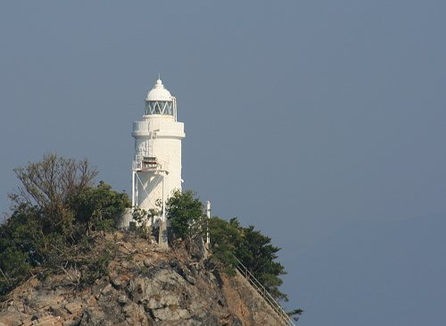
Date unknown. Active; focal plane 23 m (75 ft); three white flashes every 12 s. 10.5 m (31 ft) round cylindrical stone tower with lantern and gallery, painted white. A Coast Guard photo is at right, Trabas has a good photo, another photo is available, Katsuhiro Okada has a distant view, and Google has a satellite view and a distant street view. This lighthouse stands atop a rocky islet in the middle of the entrance to Tokuyama Bay, about 10 km (6 mi) southwest of Kudamatsu. Accessible only by boat. Site and tower closed. ARLHS JPN-1620; JCG-5143; Admiralty M5400; NGA 9520.
* Kudamatsu (1)
1893. Inactive for many years. Approx. 8 m (26 ft) unpainted square pyramidal stone tower with a stone lantern of traditional form. Nobufumi Yoshida has a 2016 street view, a 2023 closeup is available, and Google has a satellite view. According to a blog this is the oldest lighthouse of Shūnan. Probably it has been relocated for display. The blog also has photos of a similar beacon, with no lantern, that formerly stood on the Harumi pier; its current location is unknown. Located on the Kudamatsu waterfront in Tokuyama. Site open, tower closed.
Iwa Shima Light
Iwa Shima Light, Shūnan
Japanese Coast Guard Tokuyama Office photo
* Tokuyama (Tikko Breakwater)
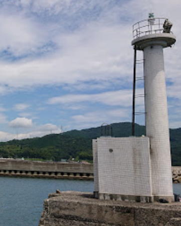
Date unknown. Active; focal plane 13 m (43 ft); green light, 2 s on, 2 s off. 11 m (36 ft) round white concrete tower with gallery, attached to a square 1-story concrete equipment shelter. Koi Nobori has the 2019 photo seen at right, Trabas has a closeup photo, Ken Katsu has a 2023 closeup photo, and Google has a satellite view. The design of this tower suggests that it may have had a lantern in the past. Located on a short breakwater in the old harbor of Tokuyama. Accessible by walking the pier. Site open, tower closed. ARLHS JPN-1666; JCG-5151; Admiralty M5404; NGA 9536.
Chinoikada (Oki-no-ikada)
Date unknown. Active; focal plane 11 m (36 ft); white flash every 4 s. 8 m (26 ft) round concrete tower. Entire lighthouse is white. Trabas has a photo and Google has a satellite view. Located on a reef in Tokuyama Kudamatsu harbor. Accessible only by boat. Site open, tower closed. ARLHS JPN-1648; JCG-5158; Admiralty M5401.6; NGA 9544.

Hōfu City Lighthouse
* No Shima (Nojima, No Sima, Suō Noshima)
1978. Active; focal plane 87 m (285 ft); white light, 3 s on, 3 s off. 19 m (62 ft) square white concrete tower with lantern and gallery. A boxlike chamber below the gallery contains a powerful spotlight that illuminates the nearby reef of Omo Se. A closeup (halfway down the page) is available and Google has a satellite view. No Shima is an inhabited island in Suō Bay about 20 km (13 mi) southwest of Kudamatsu and 15 km (9 mi) southeast of Hōfu. Passenger ferry service is available from both cites. Located on a summit near the southern tip of the island. Accessible by a 15-minute walk from the ferry terminal. Site open, tower closed. ARLHS JPN-602; JCG-5140; Admiralty M5398.5; NGA 9512.
* No Shima Kō (West Breakwater)
Date unknown. Active; focal plane 12 m (39 ft); red light, 3 s on, 3 s off. 8.5 m (28 ft) concrete post attached to a square 1-story concrete equipment shelter. Entire lighthouse is red. Shinjirō Hara has a good photo, Kazuya Tanaka has a very distant view, and Google has a satellite view. Located at the end of the west (main) breakwater of the harbor on No Shima. Accessible by walking the pier, and there's a good view from arriving ferries. Site open, tower closed. ARLHS JPN-1646; JCG-5142; Admiralty M5399; NGA 9516.

Tokuyama Light, Shūnan, September 2019
Google Maps photo by Koi Nobori
Mitaziri Nakanoseki Kō
Date unknown. Active; focal plane 14 m (46 ft); red flash every 3 s. 9.5 m (31 ft) round concrete tower with a flared top attached to a small equipment shelter. Entire lighthouse is red. Trabas has a photo and Google has a satellite view. Located on a detached breakwater outside the entrance to Hōfu harbor. Accessible only by boat. Site status unknown. JCG-5181.7; Admiralty M5396; NGA 9577.
* Nakanoseki (Nakano Saki)
1932. Active; focal plane 66 m (217 ft); white light, 2 s on, 2 s off. 12 m (39 ft) square concrete post attached to a 1-story concrete equipment building. Lighthouse-Japan.com has a page with several photos, Lighthouse Visit has a page with photos, a closeup is available, Trabas also has a closeup, and the light pokes through the trees in Google's satellite view. Located on a densely-forested promontory on the west side of the entrance to Hōfu harbor. Accessible by a hiking trail. Site open, tower closed. ARLHS JPN-1643; JCG-5193; Admiralty M5394; NGA 9584.
Saba Shima
Date unknown. Active; focal plane 47 m (154 ft); white flash every 3 s. 13 m (43 ft) square white concrete tower. No closeup photo available. Trabas has a distant view, S. Katsuragi has a distant view from the sea, and Google has a satellite view. Located atop a small island about 7 km (4.5 mi) southwest of Nakano Saki. Accessible only by boat. Site status unknown. ARLHS JPN-1651; JCG-5200; Admiralty M5390.6; NGA 9604.

Yamaguchi City Lighthouses
* Kusayama Saki
1982. Active; focal plane 128 m (420 ft); white light, 3 s on, 3 s off; in addition, a continuous white spotlight (JCG-5202) illuminates a nearby shoal. 12 m (39 ft) round cylindrical concrete tower with gallery. Entire lighthouse is white. A photo is at right, Lighthouse-Japan.com has a page with several photos, Lighthouse Visit also has a page with photos, Trabas has a closeup, the Coast Guard has a good photo, Kiso has a closeup photo, a 2021 photo and another photo are available, and Google has a satellite view. Located in a lovely and popular forest park on a high promontory jutting into Suō Bay about 15 km (9 mi) south of Ogori; a stone column marks the entrance to the park. Site open, tower closed. ARLHS JPN-313; JCG-5201; Admiralty M5390; NGA 9608.
* Aio Kō (South Breakwater)
1976. Active; focal plane 12 m (39 ft); red light, 2 s on, 2 s off. 8.5 m (28 ft) concrete post attached to a square 1-story concrete equipment room. Entire structure is red. Trabas has a closeup photo, Lighthouse Visit has a page with a photo (second lighthouse on the page), there's a photo of the light in action, and Google has a street view and a satellite view. Located at the end of the south (main) breakwater of Aio harbor. Accessible by walking the pier. Site open, tower closed. ARLHS JPN-1605; JCG-5204; Admiralty M5390.45; NGA 9616.
Kusayama Saki Light
Kusayama Saki Light, Yamaguchi, November 2011
ex-Panoramio photo copyright ice custodian; used by permission
Iwayano Hana
Date unknown. Active; focal plane 22 m (72 ft); continuous white spotlight illuminating a nearby reef. 6 m (20 ft) round cylindrical white concrete tower. Trabas has a closeup photo, Katsuhiro Okada has a 2020 photo, and Google has a satellite view. Located at the end of a long, narrow peninsula southwest of Aio. Accessible by a hiking trail; parking is available at the trailhead. Site status unknown. JCG-5206; Admiralty M5389.5; NGA 9620.

Ube City Lighthouses
Suō Tateishi
Date unknown. Active; focal plane 12 m (39 ft); white flash every 4 s. 8 m (26 ft) round cylindrical concrete tower centered on an octagonal concrete pier. Entire lighthouse is white. A Coast Guard photo is at right, Trabas has a photo, a small photo (third from last photo on the page) is available, and Google has a satellite view. NGA garbles the name as "Ta Teisi." Located on a reef in the center of the entrance to Yamaguchi harbor. Accessible only by boat. Site open, tower closed. ARLHS JPN-1664; JCG-5207; Admiralty M5389; NGA 9624.
Tokonami Kō
Date unknown. Active; focal plane 12 m (39 ft); red light, 2 s on, 2 s off. 9 m (30 ft) concrete post attached to a square 1-story concrete equipment room. Entire structure is red. Trabas has a closeup photo and Google has a street view and a satellite view. Located on the south breakwater of Tokonami harbor, a short distance east of Ube Airport. May be accessible by walking the pier. Site open, tower closed. ARLHS JPN-1667; JCG-5209; Admiralty M5387.5; NGA 9632.
Kamega Se
Date unknown. Active; focal plane 12 m (39 ft); white flash every 4 s. 14 m (46 ft) round cylindrical concrete tower with lantern and gallery, mounted on an octagonal concrete pier. Trabas has a good photo and Bing has a satellite view. Located on a shoal about 2 km (1.25 mi) south of Ube Airport. Accessible only by boat. Site open, tower closed. JCG-5210; Admiralty M5386; NGA 9636.
#Ubemisaki Kō (1)
Date unknown. Replaced. This was a 8.5 m (28 ft) concrete post attached to a square 1-story concrete equipment room. Entire structure was white. No photo available but Bing has a distant satellite view. Google's satellite view shows that the lighthouse has been replaced by a post light (focal plane 12 m (39 ft); continuous green light with a more intense flash every 5 s). Trabas has a photo of the new light. Located on the east end of a detached breakwater protecting the entrance to Ube's fishing harbor, just west of the airport. Accessible only by boat. Site open, tower closed. ARLHS JPN-1672. Active light: JCG-5211; Admiralty M5382; NGA 9640.

Suō Tateishi Light, Yamaguchi
Japanese Coast Guard Tokuyama Office photo
Motoyama
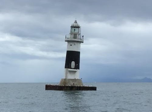
Date unknown. Active; focal plane 15 m (49 ft); white flash every 3 s. 15 m (49 ft) round concrete tower with lantern and gallery, mounted on a square concrete pier. Lighthouse painted white with one black horizontal band. Endangered. Yasushi Kidena's photo at right shows the lighthouse with a troubling lean of at least 10°. Trabas has a similar photo and Kenichiro Asai has a 2021 photo, but the lighthouse is not shown in Google's satellite view. Located in Suō Bay about 5 km (3 mi) offshore south of Ube. Accessible only by boat. Site open, tower closed. ARLHS JPN-1637; JCG-5212; Admiralty M5387; NGA 9648.
Ube Kō South Harbor Range Front
Date unknown. Active; focal plane 13 m (43 ft); continuous red light. 12 m (39 ft) round concrete tower with gallery topped by a triangular concrete daymark. Entire lighthouse is white. Trabas has a photo and Google has a satellite view. Located on the waterfront of the south harbor basin. Site and tower closed. JCG-5224; Admiralty M5380; NGA 9656.
* Ube Kō South Harbor Range Rear
Date unknown. Active; focal plane 19 m (62 ft); continuous red light. 16 m (52 ft) round concrete tower with two galleries topped by a triangular concrete daymark. Entire lighthouse is white. Trabas has a photo and Google has a street view and a satellite view. Located beside a street in the south harbor area, 240 m (0.15 mi) northeast of the front light. Site open, tower closed. JCG-5225; Admiralty M5380.1; NGA 9660.
Ube Kō West Breakwater
Date unknown. Active; focal plane 12 m (39 ft); green light, 3 s on, 3 s off. 9 m (30ft) concrete post attached to a square 1-story concrete equipment room. Entire structure is white. Trabas has a photo, Lighthouse Visit has a photo (last lighthouse on the page) and Google has a satellite view. Located on a short breakwater on the west side of Ube harbor. Site and tower closed (industrial area). ARLHS JPN-1671; JCG-5227; Admiralty M5376; NGA 9664.
 

Motoyama Light, Ube, July 2020
Google Maps photo by Yasushi Kidena

Information available on lost lighthouses:

Notable faux lighthouses:

Adjoining pages: East: Kure and Hiroshima | South: Fukuoka | West: Western Yamaguchi

Return to the Lighthouse Directory index | Ratings key

Posted January 25, 2007. Checked and revised November 1, 2023. Lighthouses: 48. Site copyright 2023 Russ Rowlett and the University of North Carolina at Chapel Hill.