Lighthouses of Japan: Kure and Hiroshima

The nation of Japan, known in Japanese as Nihon or Nippon (日本), occupies an archipelago off the east coast of Asia. The four main islands are Hokkaidō in the north, Honshū (the largest) in the center, Shikoku in the south, and Kyūshū in the southwest. The country includes thousands of other islands of all sizes; among them the Ryūkyū (Nansei) Islands are a long chain extending to the southwest and including the large island of Okinawa, and the Nanpō Islands are another long chain extending south into the Pacific Ocean. Much of Japan is mountainous but the coastal regions are densely populated and urbanized; the country's population is about 126 million.

Japan is divided into 47 prefectures. This page lists lighthouses of the western section of the Japanese prefecture of Hiroshima, located near the southwestern end of the main island of Honshū. Hiroshima Prefecture face south on the Seto Inland Sea (Seto Naikai), a network of sounds and channels separating Honshū from Shikoku. The Kure area faces Aki Bay (Aki Nada), one of the larger basins of the western Seto Inland Sea. Hirishima is at the head of Hiroshima Bay (Hiroshima Wan), a broad northward inlet of the sea. Both cities are major ports.

The city of Hiroshima was destroyed by an atomic bomb on 6 August 1945, in the last days of World War II. Several lighthouses destroyed in the explosion have been rebuilt.

In Japanese the word for a lighthouse is tōdai or toudai (灯台). The words saki and misaki are for capes and headlands, hana ("nose") is a promontory, hantō is a peninsula, shima (also spelled sima or jima) is an island, bae is a reef, iwa or shi is a rocky reef, amase or se is a shoal, wan is a bay, nada is a sound or basin, kaikyō is a strait, kawa is a river, and or minato is a harbor.

Lighthouses in Japan are operated and maintained by the Japanese Coast Guard's Maritime Safety Agency. On Honshū there is at least one Coast Guard Section Office in each prefecture, often two or more. Hiroshima Prefecture has three offices, at Onomichi, Kure and Hiroshima. This page includes the lighthouses of the Kure and Hiroshima Coast Guard Districts.

ARLHS numbers are from the ARLHS World List of Lights. JCG numbers are the Japanese Coast Guard's light list numbers. Admiralty numbers are from volume M of the Admiralty List of Lights & Fog Signals. U.S. NGA List numbers are from Publication 112.

General Sources
Lighthouses in Japan - Hiroshima
A site providing photos and data for most major Japanese lighthouses.
Lighthouse-Japan.com - Hiroshima
Another comprehensive site with photos and notes from visits to many lighthouses.
Form of a Lighthouse - Hiroshima
A large and growing web site. Cited below as FOAL.
Lighthouse Visit - Hiroshima Prefecture Lighthouses
Another site with photos of Hiroshima lighthouses.
Misty's Japanese Lighthouse Tour - Hiroshima
Photos and a few notes for lighthouses in all parts of the country.
Kure Lighthouse Photo Gallery
An interactive map leads to photos and data for lights of the Kure area.
Online List of Lights - Japan
Photos by various photographers posted by Alexander Trabas. The Hiroshima photos are by Michael Boucher.
Lighthouses in Hiroshima Prefecture
Photos available from Wikimedia.
Japan: Modern Lighthouses
Historic postcard views posted by Michel Forand.
Navionics Charts
Navigation chart for the western Inland Sea.
Aki Shiraishi Light
Aki Shiraishi Light, Hiroshima Bay
Japanese Coast Guard photo
Kure Coast Guard District Lighthouses

Takehara City Lighthouses
* Tadanoumi Kō
Date unknown. Active; focal plane 9 m (30 ft); red light, 2 s on, 2 s off. 6 m (20 ft) concrete post attached to a square 1-story concrete equipment shelter. Entire lighthouse is red. Lighthouse Visit has a page with a photo, Trabas has a closeup, FOAL has a page with several photos, and Google has a photo, a street view and a satellite view. Located at the end of the east breakwater of Tadanoumi, the harbor town of Takehara. Accessible by walking the pier. Site open, tower closed. ARLHS JPN-1764; JCG-4479; Admiralty M5713; NGA 8500.
* Ōkuno Shima
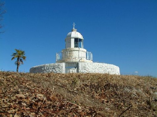
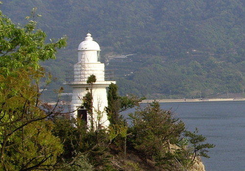
1892. Active; focal plane 21 m (69 ft); white or red light, depending on direction, 3 s on, 3 s off. 7 m (23 ft) round stone tower with lantern and gallery. Entire lighthouse painted white. A 2008 photo is at right, Lighthouse-Japan.com has a page with several good photos, FOAL also has a page with good photos, Lighthouse Visit also has a page, Trabas has a photo, a 2023 photo and a 2009 closeup are available, and Google has a street view and a satellite view. Another in the chain of historic lights marking the northern channel of the Inland Sea west of Onomichi. Ōkuno Shima is a small island north of the much larger island of Ōmi Shima, which is one of the islands crossed by the Nishi-Seto Expressway connecting Honshū and Shikoku. Located in a park at the southern tip of the island. Accessible by road and a short walk. Site open, tower closed. . ARLHS JPN-458; JCG-4481; Admiralty M5712; NGA 8504.
Ikari Shima
Date unknown. Active; focal plane 11 m (36 ft); one short and one long green flash every 8 s. 8 m (26 ft) round concrete tower mounted on a concrete pier. Entire lighthouse is green. Trabas has a good photo and Google has a satellite view. Located about 500 m (0.3 mi) off the mainland south of Yoshina. Accessible only by boat. JCG-4646; Admiralty M5710.6; NGA 8824.
Okuno Shima Light
Ōkuno Shima Light, Takehara, April 2008
ex-Panoramio Creative Commons photo by kyokyo

Ōsakikamijima Town Lighthouses
#Mebaru Saki (?)
1897. Inactive since 2009. 4.5 m (15 ft) round stone tower with lantern and gallery. Entire lighthouse painted white. The lighthouse is missing from Google's satellite view. This historic lighthouse was dismantled in March 2009. The stones were numbered carefully so that the lighthouse could be rebuilt, one source says at a history museum nearby. More information is needed! Formerly located at the northeastern tip of Ōsakikami Shima, a large island in the Inland Sea south of Takehara. Site status unknown. ARLHS JPN-338; ex-JCG-4483; ex-Admiralty M5704; ex-NGA 8508.
Mebaruzaki (Mebaru Saki) Kō
Date unknown. Active; focal plane 15 m (49 ft); green flash every 3 s. 11 m (36 ft) square skeletal tower with gallery, painted white. FOAL has a page with good photos, Lighthouse Visit has a photo, Trabas has a photo, and Google has a street view and a satellite view. This is not so much a harbor light; it is a passing light for vessels rounding the northeastern tip of Ōsakikami Shima. Located at the point of the cape. Site and tower closed (behind a high fence). JCG-4484; Admiralty M5706; NGA 8512.
* Nakano Hana
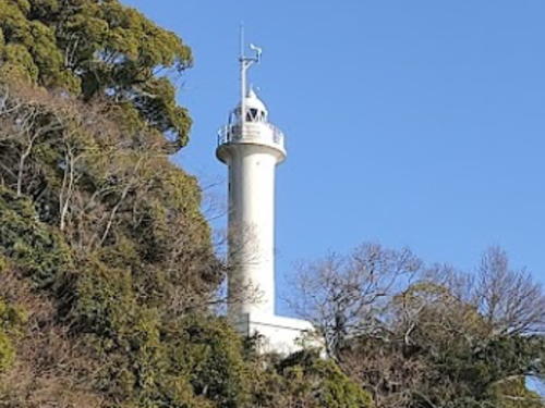
1894. Active; focal plane 45 m (148 ft); three flashes every 13 s, red or white depending on direction. 5 m (17 ft) round stone tower with lantern and gallery. Entire lighthouse painted white. The Coast Guard's photo is at right, FOAL's page has excellent photos, Lighthouse-Japan.com has a page with several good photos, Lighthouse Visit has a page for the lighthouse, Trabas has a view from the sea, and Google has a street view and a satellite view. Accessible by road; there's a short walk from a nearby parking area. Located at the southeastern tip of Ōsakikami Shima. Site open, tower closed. . ARLHS JPN-397; JCG-4487; Admiralty M5702; NGA 8520.
Nakano Hana Light
Nakano Hana Light, Ōsakikami Shima, Toyota District
Japanese Coast Guard Kure Office photo
Tsukuga (Tukuga) Shima
Date unknown. Active; focal plane 10 m (33 ft); one short and one long red flash every 8 s. 10 m (33 ft) round concrete tower centered on a large octagonal stone pier. Entire tower is red. Trabas has a distant view and Google has a satellite view. Located on a reef about 5 km (3 mi) northwest of the western end of Ōsakikami Shima. Accessible only by boat. Site open, tower closed. JCG-4648; Admiralty M5698.4; NGA 8828.

Higashihiroshima City Lighthouses
* #Akitsu Kō
1962. Replaced. 8.5 m (28 ft) concrete post attached to a square 1-story concrete equipment shelter. Entire lighthouse is white. Trabas has a closeup photo, FOAL's page has photos, Lighthouse Visit has a page for the light, and Google has a 2013 street view. Suemitsu Yamamoto's 2020 distant photo and Google's 2022 street view and satellite view show that the light is now on a post (focal plane 11 m (36 ft); continuous green light with a more intense flash every 5 s). Located at the end of the west breakwater of Akitsu harbor. Accessible by walking the pier. Site open, tower closed. ARLHS JPN-1723. Active light: JCG-4649; Admiralty M5699; NGA 8832.

Kure City Lighthouses
Kure is a major shipbuilding center and a traditional home port of the Japanese Navy. The city faces a beautiful sheltered harbor about 16 km (10 mi) southeast of Hiroshima. Its population is about 210,000.
Shimoikari (Simoikari) Iso
Date unknown. Active; focal plane 9.5 mm (31 ft); two white flashes every 5 s. 7.5 m (25 ft) round cylindrical concrete tower, mounted on a concrete pier. Lighthouse painted black with a red horizontal band. Trabas has a distant photo and Google has a satellite view. Located on a reef about 2.5 km (1.5 mi) south of Oshiba Shima. Accessible only by boat. Site open, tower closed. JCG-4650; Admiralty M5698; NGA 8836.
Mitarai Ōshima
1975. Active; focal plane 11 m (36 ft); white flash every 3 s. 9 m (30 ft) concrete post attached to a square 1-story concrete equipment shelter. Entire lighthouse is white. FOAL's page has good photos, Lighthouse Visit has photos (third lighthouse on the page), there's another page for the lighthouse, Trabas has a closeup, and Google has a satellite view. Located on the northern point of an island off the northeast point of Osaki Shimo-jima, marking the entrance to a narrow passage. May be accessible only by boat. Site open, tower closed. JCG-4656; Admiralty M5697.2; NGA 8856.
* Mitarai Kō Breakwater
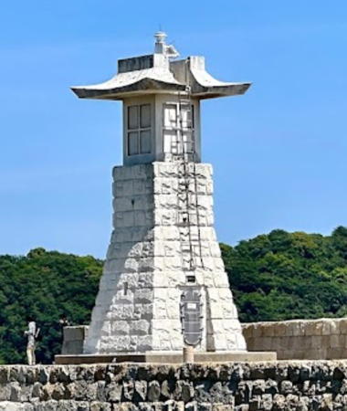
1940. Active; focal plane 13 m (43 ft); green light, 3 s on, 3 s off. 8.5 m (28 ft) square tapered stone tower with a crown resembling a pagoda. The light is displayed from the "roof" of the pagoda. A 2023 photo is at right, Trabas has an excellent closeup photo, Lighthouse-Japan.com has a page with several photos, FOAL's page has good photos. Lighthouse Visit has photos, and Google has a street view and a satellite view. The lighthouse has a unique and interesting design, intended to resemble an ishidoro, or stone lantern, used for decorating gardens, shrine precincts, etc. Mitarai is a town near the eastern tip of Osaki Shimo-jima, an island southwest of Ōsakikami Shima. Located at an elbow of the breakwater mole at Mitarai. Accessible by walking the mole. Site open, tower closed. ARLHS JPN-2399; JCG-4654; Admiralty M5697; NGA 8848.
Kamo Se (Kamose) (2?)
Date unknown (station established 1952). Active; focal plane 21 m (69 ft); white flash every 4 s. 7 m (23 ft) round white fiberglass tower with gallery. Trabas has a photo, Lighthouse Visit has a photo (second lighthouse on the page), Kenichiro Asai has a 2023 photo, and Google has a satellite view. Located on an isolated rock off the southwestern tip of Okubi Shima. Accessible only by boat. Site status unknown. ARLHS JPN-1740; JCG-4668; Admiralty M5696; NGA 8892.
#Kamagari Kō
Date unknown. Removed in 2018. This was a 9.5 m (31 ft) concrete post rising from a rectangular 1-story equipment shelter. Entire lighthouse is white. FOAL's page has photos. The lighthouse was deactivated in February 2018 and Google's September 2019 street view and satellite view confirm its removal. Formerly located at the end of the original east breakwater of Kamagiri, on the north coast of Kamagarini Shima. Site open. ARLHS JPN-1738; ex-JCG-4660; ex-Admiralty M5695.7; NGA 8872.

Mitarai Kō Breakwater Light, Osaki Shimo-jima, Kure, May 2023
Google Maps photo by kumokiri rabbit
Kamagarini Shima
1973. Active; focal plane 9 m (30 ft); white flash every 4 s. 8 m (26 ft) square cylindrical concrete tower centered on a square 1-story equipment room and mounted on a square concrete pier. Entire lighthouse is white. The Coast Guard has a photo, FOAL's page has photos, Trabas has a closeup, Lighthouse Visit has a photo, additional photos and a drone view are available, and Google has a satellite view. (Tom Zane points out that the rope connecting the two peaks in the Coast Guard photo is a shimenawa, a traditional Japanese good luck or good fortune symbol. It consists of a left hand plaited straw rope, so wound because the left is the pure or fortunate side. Groups of straw pendants hang from the rope.) Located on a skerry off the northeastern tip of Kamagarini Shima, about 20 km (13 mi) east of Kure. Accessible only by boat. Site open, tower closed. ARLHS JPN-1739; JCG-4659; Admiralty M5695.8; NGA 8868.
#Meneko Shima
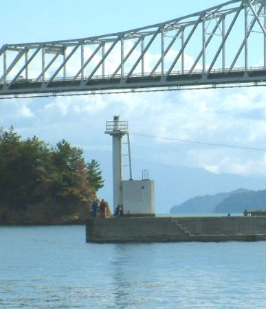
1966. Inactive since 2008. This was a 10 m (33 ft) round cylindrical white concrete tower with double gallery. A photo is available but the tower is not to be found in Google's sea view or satellite view. This lighthouse was located off the southern tip of Meneko Shima, practically under the bridge crossing the Menekonoseto Strait, about 10 km (6 mi) southeast of Kure. Site and tower closed. ARLHS JPN-1749; ex-JCG-4662; ex-Admiralty M5695.4; ex-NGA 8884.
Kure Aga Kō West Breakwater (Hiro Wan Aga Oki)
1978. Active; focal plane 12 m (39 ft); red flash every 3 s. 10 m (33 ft) square skeletal tower with enclosed upper portion. Lighthouse painted red. Trabas has a good photo, Lighthouse Visit has a page with a closeup photo, additional photos are available, and Google has a satellite view. Located at the south end of a detached breakwater protecting Kure's commercial harbor. Accessible only by boat. Site status unknown. ARLHS JPN-1734; JCG-4782; Admiralty M5694.5; NGA 9068.
* Ondo (3)
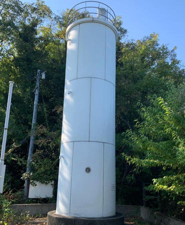
2002 (station established 1959). Active; focal plane 38 m (125 ft); white light, 3 s on, 3 s off. 10 m (33 ft) round cylindrical fiberglass tower with double gallery, rising from one end of a rectangular 1-story equipment building. Entire lighthouse is white. Yukihiro Matsumura's photo is at right, Lighthouse-Japan.com has a page with photos, FOAL's page has photos, Lighthouse Visit has a page with photos, Trabas has Boucher's photo, and Google has a street view and a satellite view. This lighthouse guides ships entering the north end of the narrow strait separating the large island of Kurahashi Shima from the mainland at Ondo, about 7 km (4.5 mi) south of Kure. The lighthouse stands above private property and some local guidance may be needed to reach it. Located on a bluff at the northern tip of Kurahashi Shima in the city of Ondo. Site open, tower closed. . ARLHS JPN-489; JCG-4771; Admiralty M5693; NGA 9056.

Ondo Light, Ondo, August 2023
Instagram photo by Yukihiro Matsumura
Akisengaiiwa (Aki Sengai)
1965. Active; focal plane 10 m (33 ft); three quick white flashes every 10 s. 12 m (39 ft) round concrete post supporting a large octagonal concrete platform. Lighthouse painted black with one yellow horizontal band. Trabas has a photo, FOAL has a photo, Lighthouse Visit has a photo (first lighthouse on the page), and Google has a satellite view. Located off the east side of the southern tip of Kurahashi Shima. Accessible only by boat. Site open, tower closed. JCG-4702; Admiralty M5656; NGA 8908.
Mitsuishi (Mitsu Ishi, Mitu Isi)
1927. Active; focal plane 16 m (52 ft); white flash every 3 s. 9.5 m (31 ft) square cylindrical concrete tower with lantern and gallery. Entire lighthouse is white. Trabas has Boucher's photo, Lighthouse Visit has a photo (second lighthouse on the page), and Google has a satellite view. This lighthouse marks a major hazard at a crucial location in the Seto Inland Sea. Located on a reef about 4 km (2.5 mi) south of Kurahashi Shima. Accessible only by boat. Site open, tower closed. ARLHS JPN-1752; JCG-4701; Admiralty M5654; NGA 8904.
* Kashima (Kurahashi) Kō
1968. Active; focal plane 14 m (46 ft); green light, 3 s on, 3 s off. 8.5 m (28 ft) concrete post attached to a square 1-story concrete equipment shelter. Entire lighthouse is white. A Coast Guard photo is at right, Lighthouse Visit has a photo (first lighthouse on the page), Trabas has a closeup photo, additional photos are available, and Google has a street view and a satellite view. Kashima Shima is a smaller island just to the south of Kurahashi Shima. Located at the end of the east breakwater of Kashima harbor, at the northern end of the island. Accessible by walking the pier. Site open, tower closed. ARLHS JPN-1746; JCG-4703; Admiralty M5655; NGA 8912.
Akimanaitaiwa (Aki Manaita Ishi)
Date unknown. Active; focal plane 11 m (36 ft); two white flashes every 5 s. 8 m (26 ft) concrete post carrying a large round top section, mounted on a square concrete pier. Lighthouse painted black with one red horizontal band. Trabas has Boucher's photo, Lighthouse Visit has a photo (third lighthouse on the page), and Google has a satellite view. Located off the south end of Kashima Shima, a smaller island just to the south of Kurahashi Shima. Accessible only by boat. Site open, tower closed. JCG-4704.1; Admiralty M5654.5; NGA 8914.
Kashima Kō Light
Kashima Kō Breakwater Light, Kashima, Kure
Japanese Coast Guard Kure Office photo
Nishigobanno (Nisigobanno) Bae
1904. Active; focal plane 15 m (49 ft); nine quick white flashes every 15 s. 17 m (56 ft) round stone tower with lantern and gallery, mounted on a round concrete pier. Lighthouse painted bright yellow with one black horizontal band. The Coast Guard's photo is at right, Trabas has Boucher's photo, Lighthouse Visit has a photo (second lighthouse on the page), FOAL has photos (bottom of the page), and Bing has a satellite view. This historic beacon guides ships rounding Kurahashi Shima en route to Hiroshima from the Inland Sea. Located about 3 km (2 mi) southwest of the southwestern tip of Kurahashi Shima. Accessible only by boat. Site open, tower closed. JCG-4708; Admiralty M5664; NGA 8916.
Dentaro Hana
1974. Active; focal plane 17 m (56 ft); white flash every 4 s. 8.5 m (28 ft) concrete pillar with gallery, mounted on a square concrete equipment room. Entire lighthouse is white. FOAL's page has photos, another page for the lighthouse has several photos, Lighthouse Visit has a photo (third lighthouse on the page), Trabas has a closeup photo, Kenichiro Asai has a 2023 photo, and Google has a satellite view. Located on the southwestern tip of Kurahashi Shima. Accessible only by boat. Site open, tower closed. ARLHS JPN-1726; JCG-4789; Admiralty M5664.4; NGA 9092.
* #Ryōshida (Choshida, Ryosida) Kō
1986. Replaced in 2013. This was a 8.5 m (28 ft) concrete post attached to a square 1-story concrete equipment shelter. It was replaced by a simple 5 m (17 ft) post (focal plane 9 m (30 ft); continuous red light with a more intense flash every 3 s.) Entire lighthouse is red. There's another page for the original lighthouse. FOAL's photos, Lighthouse Visit's photo (third lighthouse on the page), Trabas's photo and Google's street view and satellite view show the new light. Located at the end of the south breakwater of Ryōshida, a port on the west coast of Kurahashi Shima. Accessible by walking the pier. Site open, tower closed. JCG-4787.5. Current light: Admiralty M5664.7; NGA 9088.
Kourume Shima (Kure)
1948. Active; focal plane 22 m (72 ft); white flash every 4 s. 11 m (36 ft) round cylindrical concrete tower with a flared top and gallery. Entire lighthouse is white. Lighthouse Visit has a page with photos, another photo is available, Trabas has Boucher's photo, Shoji Kodama has a 2022 photo, and Google has a satellite view. Kure's beautiful harbor is a traditional home port for the Japanese Navy. Kourume Shima is a small island off the harbor of Kure, within 400 m (1/4 mi) of the mainland. Accessible only by boat. Site status unknown. ARLHS JPN-1744; JCG-4769; Admiralty M5692; NGA 9052.
Nishigobanno Bae Light
Nishigobanno Bae Light, Kure
Japanese Coast Guard Kure Office photo

Hiroshima Coast Guard District Lighthouses

Etajima City Lighthouses
Eta Shima (also called Etajima or Edajima) is a large island occupying the southeastern third of Hiroshima Bay, southwest of Kure. The island is accessible by a bridge from Kurahashi Shima and by ferries from Hiroshima and Kure.
Aki Shiraishi (Siraisi)
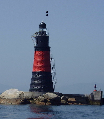
1903. Active; focal plane 19 m (62 ft); two white flashes every 10 s. 20 m (66 ft) round stone tower with lantern and gallery, mounted on a round concrete pier. Lighthouse painted black with one red horizontal band. A Coast Guard photo is at the top of this page, Trabas has Boucher's photo, Lighthouse Visit has a distant view (last lighthouse on the page), and Bing has a satellite view. Very similar to the Nishigobanno Hana Light. Located near the center of Hiroshima Bay about 12 km (7.5 mi) east of Iwakuni. Accessible only by boat. Site open, tower closed. JCG-4712; Admiralty M5668; NGA 8924.
Manaita Syo (Aki Manaita Sho)
1960. Active; focal plane 11 m (36 ft); two white flashes every 5 s. 9 m (30 ft) round concrete tower with double gallery, mounted on a round concrete pier. Lighthouse painted black with one red horizontal band. Trabas has Boucher's photo, Lighthouse Visit has a photo (first lighthouse on the page), FOAL has a photo (near the bottom of the page), and Google has a satellite view. Located about 2.5 km (1.5 mi) southwest of the northwestern tip of Eta Shima (Etajima), a large island protecting the harbor of Hiroshima. Accessible only by boat. Site open, tower closed. JCG-4737; Admiralty M5679; NGA 8964.
Nakano Se (2?)
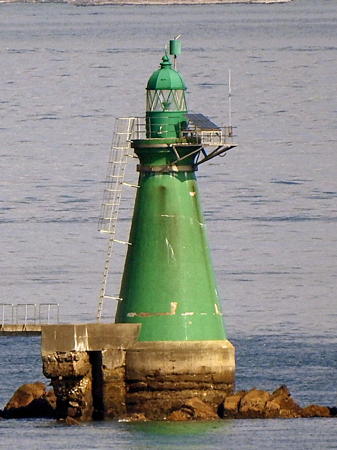
1903 (?). Active; focal plane 12 m (39 ft); one long and two short green flashes every 8 s. 15 m (49 ft) round strongly conical concrete tower with lantern and gallery, painted green. The Coast Guard's photo is at right, Trabas has Boucher's photo (also seen at right), Garrett McGowan has also posted an excellent closeup photo, Lighthouse Visit has a photo (second lighthouse on the page), FOAL has a photo (middle of the page), and Bing has a satellite view. The fact that this beacon is concrete rather than stone suggests it may have been replaced at some time in its history. Located about 2.5 km (1.5 mi) off the northwestern tip of Eta Shima. Accessible only by boat. Site open, tower closed. JCG-4741; Admiralty M5680; NGA 8980.
Aki Eno Shima
1904. Active; focal plane 49 m (161 ft); white flash every 4 s. 13.5 m (44 ft) round cylindrical concrete tower with gallery; the lantern has been removed. Entire lighthouse is white. Trabas has Boucher's photo, FOAL has a photo (near the top of the page), and Google has a satellite view. Located atop a small island about 2.5 km (1.5 mi) northwest of Ando Shima and 1.2 km (3/4 mi) east of the eastern tip of Eno Shima, another large island lying southwest of Hiroshima. Accessible only by boat. Site status unknown. ARLHS JPN-1721; JCG-4742; Admiralty M5681; NGA 8984.

Nakano Se Light, Hiroshima
photo copyright Michael Boucher; used by permission
Ando Shima
1967. Active; focal plane 18 m (59 ft) white flash every 4 s. 9 m (30 ft) round cylindrical concrete tower with double gallery, painted white. Trabas has a photo, Lighthouse Visit has a photo (third lighthouse on the page), FOAL has a photo (next to last row on the page), and Bing has an indistinct satellite view of the island. Located on an islet north of the northwestern tip of Eta Shima. Accessible only by boat. Site status unknown. ARLHS JPN-1725; JCG-4743; Admiralty M5680.4; NGA 8988.
Kasa Iso
1981. Active; focal plane 10 m (33 ft); two white flashes every 5 s. 7.5 m (25 ft) concrete post supporting a large round platform structure. Lighthouse painted black with a red horizontal band. Trabas has Boucher's photo, Lighthouse Visit has a photo (last lighthouse on the page), FOAL has photos (middle of the page), and Google has a street view and a satellite view. Located 500 m (0.3 mi) off the north end of Eta Shima. Accessible only by boat. Site open, tower closed. JCG-4740; Admiralty M5680.9; NGA 8976.
Yakata Ishi
1904. Active; focal plane 7.5 m (25 ft); quick-flashing white light. 8 m (26 ft) round stone tower with lantern and gallery, mounted on a round concrete pier. Lower half of lighthouse painted bright yellow, upper half black. Trabas has Boucher's photo (also seen at right), Lighthouse Visit has photos (last lighthouse on the page), FOAL has a photo (middle of the page), Kenichiro Asai has a 2022 photo, and Google has a satellite view. Located on a rocky reef just off the northern tip of Eta Shima. Accessible only by boat. Site open, tower closed. JCG-4747; Admiralty M5690; NGA 9000.
Kakiura (Kakinoura) Kō
1983. Active; focal plane 13 m (43 ft); green flash every 4 s. 9 m (30 ft) concrete post attached to a square 1-story concrete equipment shelter. Entire lighthouse is white. Trabas has a closeup photo, two additional photos (second and third photos on the page) are available, Lighthouse Visit has a photo (first lighthouse on the page), and Google has a satellite view. Located on a detached breakwater at the entrance to Kakiura harbor on the east coast of Etajima. Accessible only by boat. Site open, tower closed. ARLHS JPN-1737; JCG-4783; Admiralty M5666.5; NGA 9072.
Ogaki Kō (Nomishima)
1965. Active; focal plane 11 m (36 ft); green flash every 3 s. 9 m (30 ft) concrete post attached to a square 1-story concrete equipment shelter. Entire lighthouse is white. Trabas has a closeup photo, Lighthouse Visit has a photo (second lighthouse on the page), the light is seen in the background of a photo (third photo on the page) of the Kakiura light, and Google has a satellite view and a very distant street view. Located on a breakwater attached to an island sheltering the harbor of Ogaki, just south of Kakiura on the east coast of Etajima. Accessible only by boat. Site open, tower closed. ARLHS JPN-1754; JCG-4784; Admiralty M5666; NGA 9076.

Yakata Ishi Light, Hiroshima
photo copyright Michael Boucher; used by permission

Hiroshima City Lighthouses
The prefectural capital of Hiroshima is a city of about 1.2 million residents at the head of Hiroshima Bay, a broad inlet of the Seto Inland Sea. The city has been completely rebuilt after being destroyed by the atomic bombing of 6 August 1945.
* Ujina (Uzina)
1950. Active; focal plane 46 m (151 ft); flash every 5 s, alternately red and white. 21 m (69 ft) round cylindrical concrete tower with lantern and gallery, centered on a square 1-story service building; 6th order Fresnel lens. Entire lighthouse is white. Tim Slessor's photo is at right, Lighthouse-Japan.com has a page with good photos, Lighthouse Visit also has a page with photos, FOAL's page has photos, Trabas has a drone view, Paul Walsh has a 2022 view from the nearby beach, a 2016 view is available, and Google has a satellite view and a distant sea view. Located on the tip of a wooded promontory projecting into the busy and beautiful harbor of Hiroshima. Easily accessible by road and parking is provided, so it is surprising that there are not more photos of this lighthouse. Site open, tower closed. . ARLHS JPN-735; JCG-4753; Admiralty M5687; NGA 9004.
Hiroshima East Breakwater
1978. Active; focal plane 17 m (56 ft); red light occulting once every 4 s. 19 m (62 ft) round cylindrical concrete tower with lantern, gallery, and a tall "dunce cap" crown; 5th order Fresnel lens. Entire lighthouse painted red. Trabas has Boucher's photo, a page for the lighthouses has another photo, Lighthouse Visit has a photo (second lighthouse on the page), FOAL has photos (bottom of the page, on the right), Yoichi Kono has a 2023 closeup, and Google has a sea view and a satellite view. The "dunce cap" on these modern lighthouses is a historical touch recalling similar crowns on the lighthouses of Yokohama harbor. Located at the end of the detached east breakwater of Hiroshima's modern port, west of the Uzina lighthouse. Site and tower closed, but there should be excellent views from arriving or departing ferries. ARLHS JPN-1769; JCG-4754; Admiralty M5687.5; NGA 9008.

Ujina Light, Hiroshima, January 2022
Google Maps photo by Paul Walsh
Hiroshima West Breakwater
1971. Active; focal plane 17 m (56 ft); green light occulting once every 4 s. 19 m (62 ft) round cylindrical concrete tower with lantern, gallery, and a tall "dunce cap" crown; 5th order Fresnel lens. Entire lighthouse painted white. A photo is at right, Trabas has Boucher's photo (also seen at right), a page for the lighthouses has another photo, FOAL has photos (bottom of the page, on the left), Lighthouse Visit has a photo (last lighthouse on the page), a 2023 view from the sea is available, and Google has a sea view and a satellite view. The "dunce cap" on these modern lighthouses is a historical touch recalling similar crowns on the lighthouses of Yokohama harbor. Located at the end of the west breakwater of Hiroshima's modern port, west of the Uzina lighthouse. Site and tower closed, but there should be excellent views from arriving or departing ferries. ARLHS JPN-1770; JCG-4755; Admiralty M5687.4; NGA 9012.
Kusatsu (Kusatu) Gyoko South Breakwater
1981. Active; focal plane 11 m (36 ft); green light, 2 s on, 2 s off. 8.5 m (28 ft) concrete post with gallery centered on a square 1-story equipment room. Entire lighthouse is white. Trabas has a closeup photo, Lighthouse Visit has a photo (2/3 the way down the page, on the right), FOAL has a photo (middle of the page, on the right), and Google has a satellite view. Located at the east end of a detached breakwater protecting the fishery harbor on the west side of Hiroshima. Accessible only by boat. Site and tower closed. ARLHS JPN-1748; JCG-4759; Admiralty M5683; NGA 9028.

Hatsukaichi City Lighthouses
Kame Ishi (Kame Iso)
Date unknown. Active; focal plane 10 m (33 ft); one long and one short green flash every 8 s. 8 m (26 ft) square cylindrical concrete tower, mounted on a round concrete pier. Entire lighthouse is green. Trabas has a photo, Lighthouse Visit has a page for the light, FOAL has a photo (bottom of the page, on the left), and Google has a satellite view. Located off the west coast of Eno Shima. Accessible only by boat. Site open, tower closed. JCG-4764; Admiralty M5677; NGA 9040.
#Shinkai (Sinkai, Singai) Hana (2) (?)
1951 (station established 1899). Inactive since 2008 and later demolished; Google's street view and satellite view confirm that the tower has been removed. This was a 7 m (23 ft) round concrete tower with gallery, attached to a small concrete equipment shelter. Entire lighthouse was white. Additional photos are available. The original lighthouse was destroyed by the storm surge of a typhoon in 1949. This lighthouse stood on the mainland at the narrowest point of the strait between the mainland and the island of Eno Shima; the strait here is about 500 m (0.3 mi) wide. Accessible by road. Site open. ARLHS JPN-794; ex-JCG-4765; ex-Admiralty M5676; ex-NGA 9048.

West Breakwater Light, Hiroshima
photo copyright Michael Boucher; used by permission

Information available on lost lighthouses:

Notable faux lighthouses:

Adjoining pages: East: Onomichi Area | South: Northern Ehime | West: Eastern Yamaguchi

Return to the Lighthouse Directory index | Ratings key

Posted January 25, 2007. Checked and revised October 26, 2023. Lighthouses: 40. Site copyright 2023 Russ Rowlett and the University of North Carolina at Chapel Hill.