Lighthouses of Japan: Fukuoka Area

The nation of Japan, known in Japanese as Nihon or Nippon (日本), occupies an archipelago off the east coast of Asia. The four main islands are Hokkaidō in the north, Honshū (the largest), Shikoku in the south, and Kyūshū in the southwest. The country includes thousands of other islands of all sizes; among them the Ryūkyū (Nansei) Islands are a long chain extending to the southwest and including the large island of Okinawa, and the Nanpō Islands are another long chain extending south into the Pacific Ocean. Much of Japan is mountainous but the coastal regions are densely populated and urbanized; the country's population is about 126 million.

Japan is divided into 47 prefectures. Located at the southwestern end of the Japanese archipelago, Kyūshū is divided into seven prefectures. This page includes lighthouses of Fukuoka Prefecture on the northern coast of the island. Western Fukuoka faces northwest on the Tsushima Strait and the Sea of Japan while Eastern Fukuoka faces northeast on the Seto Inland Sea, which separates Kyūshū from Honshū and Shikoku. In between the narrow Kanmon Strait connects the Inland Sea and Sea of Japan. This page has the lighthouses of the western part of the prefecture and the Kitakyūshū Area page covers the eastern half.

In Japanese the word for a lighthouse is tōdai or toudai (灯台). The words saki and misaki are for capes and headlands, hana ("nose") is a promontory, hantō is a peninsula, shima (also spelled sima or jima) is an island, bae is a reef, iwa or shi is a rocky reef, amase or se is a shoal, wan is a bay, nada is a sound or basin, kaikyō is a strait, kawa is a river, and or minato is a harbor.

Lighthouses in Japan are operated and maintained by the Japanese Coast Guard's Maritime Safety Agency. There is at least one Coast Guard Section Office in each prefecture, often two or more. Fukuoka Prefecture has three offices, at Fukuoka, Wakamatsu, and Moji. All the lights on this page except Eboshi Shima are maintained by the Fukuoka Office.

Fukuoka Prefecture also has a short southern coastline on Ariake Bay. Lighthouses of the Ariake coast are on the Kumamoto Mainland page.

A note on the Sea of Japan/East Sea controversy: The Directory takes no side in any international dispute; it makes use of the terminology, names, and spellings as they currently exist in each area covered. The sea between Japan and Korea is called the Sea of Japan on the pages for Japan and the East Sea on the pages for Korea.

ARLHS numbers are from the ARLHS World List of Lights. JCG numbers are the Japanese Coast Guard's light list numbers. Admiralty numbers are from volume M of the Admiralty List of Lights & Fog Signals. U.S. NGA List numbers are from Publication 112.

General Sources
Lighthouses in Japan - Fukuoka
This site has photos and data for the major Japanese lighthouses.
Form of a Lighthouse - Fukuoka
Another site with many photos of Japanese lighthouses, cited below as FOAL.
Lighthouse Visits
This site has photos for many lighthouses in this area.
Lighthouse-Japan.com - Fukuoka
This site has good photos and background information for many of the major lighthouses.
Our Lighthouses of Fukuoka Prefecture
A comprehensive collection of photos of lighthouses in Fukuoka.
Coast of Japan - Cape/Lighthouse Index
This site has numerous photos of Fukuoka lighthouses. Entirely in Japanese but lighthouses can be located by their JCG numbers.
Lighthouses in Fukuoka Prefecture
Photos by various photographers available from Wikimedia.
Online List of Lights - Japan - Kyushu - Northwest Coast
Photos by various photographers posted by Alexander Trabas.
Navionics Charts
Navigation chart for northern Kyūshū.


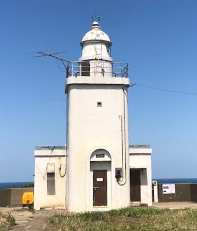
Okino Shima Light, Sea of Japan, April 2020
Instagram photo by Chie Zō
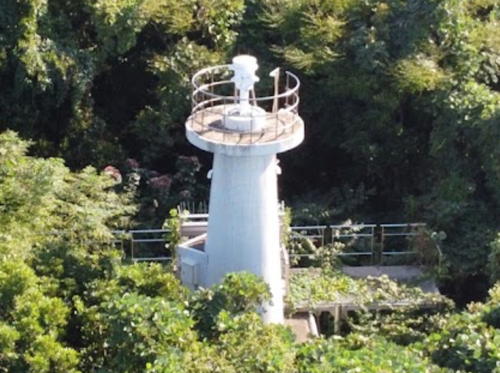

Nishima Misaki Light, Fukuoka, October 2021
Google Maps photo (by M K
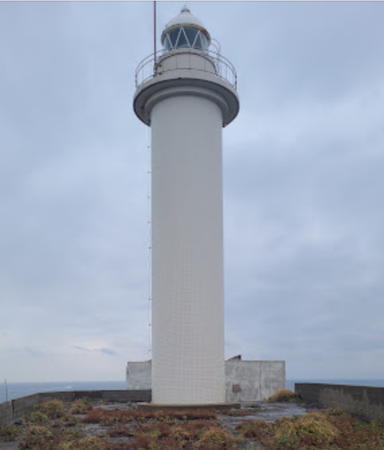
Eboshi Shima Lighthouse
Eboshi (Ebosi, Yebosi) Shima (2)
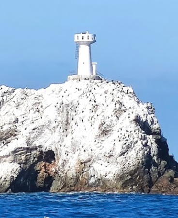
1975 (station established 1875). Active; focal plane 56 m (184 ft); white flash every 15 s. 16 m (52 ft) round cylindrical concrete tower with lantern and gallery. Entire lighthouse is white. 1-story keeper's house and a larger building, possibly a communications station. A Coast Guard photo is at right, a 2021 closeup photo is available, Chie Ikeda has a 2021 view from the sea, a Coast Guard has a view from the sea and an aerial view showing the stairway zigzagging up to the light station, and Trabas also has a view from the sea, but the island is not shown in Google's satellite view. This isolated lighthouse guides ships approaching the Kanmon Strait from the southwest. Eboshi Shima is a giant, steep-sided rock isolated in the sea about 25 km (15 mi) north of Karatsu. Although the island is attached to Fukuoka Prefecture and Itoshima City, the light station is maintained by the Karatsu Coast Guard Office in neighboring Saga Prefecture. The original lighthouse was an octagonal cast iron tower. The original 1st order Fresnel lens is displayed at the Japanese Lighthouse Association Museum at Nojima Saki Light near Tōkyō. The island was made a national nature reserve in 1995. Accessible only by helicopter or by boat in heavy seas. Site and tower closed. ARLHS JPN-058; JCG-5859; Admiralty M5262; NGA 12276.

Itoshima City Lighthouses
Fukuyoshi (Iso Saki) Kō
1985. Active; focal plane 13 m (43 ft); red flash every 5 s. 9.5 m (31 ft) concrete post attached to a square 1-story concrete equipment shelter. Entire lighthouse is red. Trabas has a photo, FOAL's page has photos, and Google has a satellite view and a street view across the harbor. Located at the end of the west (main) breakwater of Fukuyoshi harbor. Accessible by walking the pier. Site open, tower closed. ARLHS JPN-2348; JCG-5865.5; Admiralty M5269.8; NGA 12280.
* Kishi Kō
1976. Active; focal plane 11 m (36 ft); continuous green light with a more intense flash every 3 s. 8.5 m (28 ft) concrete post attached to a square 1-story concrete equipment shelter. Entire lighthouse is white. Trabas has a photo and Google has a distant street view and a satellite view. Located at the end of the west breakwater of Kishi harbor. Accessible by walking the pier. Site open, tower closed. ARLHS JPN-2005; JCG-5863; Admiralty M5269.94; NGA 12288.
Chikuzen (Tikuzen) No Se
Date unknown. Active; focal plane 15 m (49 ft); one short and one long green flash every 8 s. 14 m (46 ft) tapered round concrete tower, painted green. Trabas has a closeup photo, another photo is available, and Google has a satellite view. Located on a reef in the eastern entrance to Karatsu Bay. Accessible only by boat. Site open, tower closed. JCG-5861; Admiralty M5269.96; NGA 12284.

Eboshi Shima Light, Sea of Japan, December 2021
Google Maps photo by hrtm
Tōdai Se (Lighthouse Rock)
Date unknown. Active; focal plane 13 m (43 ft); two white flashes every 5 s. 12 m (39 ft) concrete post rising from a square 1-story concrete equipment shelter and mounted on a concrete pier. Lighthouse painted black with a red horizontal band. Trabas has a distant view and Ren Hasegawa has a 2022 distant view but the light is not shown in Google's satellite view. Located on a reef about 4 km (2.5 mi) northeast of the Mount Hikosan promontory. Accessible only by boat. Site open, tower closed. JCG-5857; Admiralty M5270; NGA 12304.

Fukuoka City Lighthouses
Fukuoka is the second-largest port city in Japan, after Yokohama. It is also Japan's sixth largest city, with a population of about 1.6 million in the city proper and 2.6 million in the metropolitan area.
Nagama Sho (Syo)
Date unknown. Active; focal plane 13 m (43 ft); quick-flashing white light. 12 m (39 ft) concrete post with an expanded top and gallery. Lower half of the lighthouse painted yellow, upper half black. Trabas has a distant photo, another photo is available (1/3 the way down the page, #5856), and Bing has a distant satellite view. Located on a reef about 5 km (3 mi) northwest of the tip of the Nishima Misaki peninsula. Accessible only by boat. Site open, tower closed. JCG-5856; Admiralty M5270.4; NGA 12308.
Nishinoura Kō
Date unknown. Active; focal plane 16 m (52 ft); green flash every 3 s. 9.5 m (31 ft) concrete post centered on a square 1-story concrete equipment shelter. Entire lighthouse is white. The Coast Guard has a photo, Trabas has a photo, and Google has a satellite view and a very distant street view. Located at the end of the west (main) breakwater of Nishinoura harbor, on the west side of the Nishima Misaki peninsula. Site status unknown. JCG-5855; Admiralty M5270.3; NGA 12312.
Nishima (Nishinoura, Nisinoura) Misaki
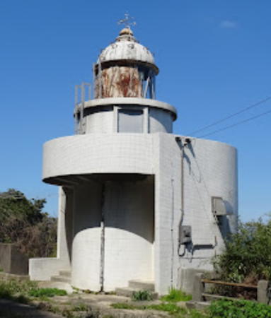
1962. Active; focal plane 78 m (256 ft); white flash every 6 s. 9 m (30 ft) round concrete tower attached to a 1-story concrete equipment building. Entire lighthouse is white. A 2021 drone view is at the top of this page, Trabas also has a drone view, Our Lighthouses has a page with photos, a 2021 closeup is available, and Google has a satellite view. Lighthouses of Japan has a page but the photo is of the Genkai Shima lighthouse (next entry). Located on a steep promontory on the west side of the entrance to Fukuoka Bay, about 20 km (13 mi) northwest of Fukuoka. Accessible by a hiking trail (local guidance may be needed). Site open, tower closed. . ARLHS JPN-420(=2016); JCG-5854; Admiralty M5271; NGA 12316.
Genkai Shima
1934. Active; focal plane 79 m (259 ft); white flash every 15 s. 12 m (39 ft) round cylindrical concrete tower, rising from a semicircular 1-story equipment building. Entire lighthouse is white. Isoji Takano's 2024 photo is at right, another photo is available, Our Lighthouses has a page with good photos, Chie Ikeda has a 2020 photo, Lighthouses of Japan has a distant view misidentified as Nishinoura Misaki, Trabas also has a distant view, and Google has a satellite view. Genkai Shima is an island in the entrance to Fukuoka Bay, about 3.5 km (2.2 mi) northeast of Nishima Misaki. Located on the northeastern side of the island. Boat transporation to the island is available, and the lighthouse is accessible by a hiking trail (local guidance may be needed). Site open, tower closed. . ARLHS JPN-069; JCG-5828; Admiralty M5272; NGA 12320.

Genkai Shima Light, Fukuoka, March 2024
Google Maps photo by Isoji Takano
Nokono Shima
1953. Active; focal plane 32 m (105 ft); white light, 3 s on, 3 s off. 12 m (39 ft) square cylindrical concrete tower. Entire lighthouse is white. Our Lighthouses has a page with closeup photos, Trabas has a photo, the Coast Guard has a view from the sea, Akifumi Nishitsuji has a closeup street view, and a Google satellite view is available. Nokono Shima is an island about 3 km (2 mi) long in the center of Fukuoka Bay. The island is accessible by ferry from Fukuoka, and the lighthouse can be reached by a hiking trail. Located on the northern tip of the island. Site status unknown. ARLHS JPN-427; JCG-5831; Admiralty M5276; NGA 12344.
Hakata Kō South Breakwater
Date unknown. Active; focal plane 11 m (36 ft); continuous red light with a more intense flash every 4 s. 9.5 m (31 ft) concrete post centered on a square 1-story concrete equipment shelter. Entire lighthouse is red. Trabas has a closeup photo and Google has a satellite view and a street view across the harbor. Hakata Kō is the port area of Fukuoka. Located at the end of the short southern section of the Hakata breakwater. Site and tower closed (this pier is not walkable). JCG-5845; Admiralty M5282.4; NGA 12368.
Hakata Kō West Breakwater (Fukuoka)
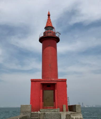
Date unknown (probably recent). Active; focal plane 17 m (56 ft); red light, 3 s on, 3 s off. 19 m (62 ft) round concrete tower with lantern and gallery and a tall "dunce-cap" roof. Entire lighthouse painted red. A 2020 photo is at right, a 2020 closeup, a 2008 photo, a 2009 photo, and another photo are available, Trabas has a good photo, FOAL has a photo (second row, right), there's a wonderful photo of the lighthouse decorated for Christmas 2005, and Google has sea view and a satellite view. Located at the end of the detached west breakwater, which is built perpendicular to the shore. Accessible only by boat. Site and tower closed. . ARLHS JPN-1998; JCG-5840; Admiralty M5282; NGA 12360.
Hakata Kō East Breakwater
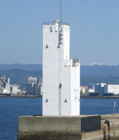
Date unknown. Active; focal plane 12 m (39 ft); green light, 3 s on, 3 s off. 10 m (33 ft) square 2-stage concrete tower with two galleries. Entire lighthouse is white. Wanz Kogata's 2022 photo is below right, Coast Guard has a photo, Trabas has a photo, Our Lighthouses has a page with a good photo, another photo is available, FOAL has a photo (second row, center, and Google has a sea view and a satellite view. This breakwater runs parallel to the shore, protecting the commercial piers. Located at the west end of the breakwater. Accessible only by boat. Site and tower closed. ARLHS JPN-079; JCG-5841; Admiralty M5281.9 (ex-M5280); ex-NGA 12372.

Hakata Kō West Breakwater Light, Fukuoka, May 2020
Google Maps photo by Neko Rondon
Ha Shima
Date unknown. Active; focal plane 11 m (36 ft); white flash every 3 s. 10 m (33 ft) concrete post attached to a 1-story square concrete equipment room. Entire lighthouse painted white. Our Lighthouses has a page with photos, another photo is available, Trabas has a distant view, and Google has a satellite view. Located at the west end of an islet on the east side of the entrance to Hakata Kō. Accessible only by boat. Site open, tower closed. JCG-5833; Admiralty M5279; NGA 12356.
Shikanoshima (Shike Shima) West Breakwater
Date unknown. Active; focal plane 11 m (36 ft); green light, 3 s on, 3 s off. 8.5 m (28 ft) round concrete tower attached to a 1-story concrete equipment building. Entire lighthouse is white. Trabas has a photo, FOAL has a photo (second row, left), and Google has a street view, a sea view and a satellite view. Shikanoshima is an island on the east side of the entrance to Fukuoka Bay; the island is connected to the city by a causeway. Located at an elbow of a detached breakwater in Shikanoshima harbor. Accessible only by boat. Site status unknown. ARLHS JPN-2021; JCG-5827; Admiralty M5275; NGA 12348.
Kurinokami Sho
Date unknown. Active; focal plane 17 m (56 ft); two white flashes every 5 s. 17 (56 ft) round tapered concrete tower with gallery. Lighthouse painted black with one red horizontal band. The light is not seen in Google's satellite view. Located on an isolated rock about 20 km (13 mi) west of Fukuma. Accessible only by boat. Site open, tower closed. JCG-5824; Admiralty M5270.6; NGA 12328.

Koga City Lighthouse
Aino Shima (Tikusen Aino Shima)
1986. Active; focal plane 87 m (285 ft); white light, 4 s on, 4 s off. 10.5 m (35 ft) concrete post centered on a square 1-story concrete equipment room. Entire lighthouse is white. Masahiro Mukai has a photo, a closeup photo is available, Toru Nishioka has a 2021 closeup, and Google has a satellite view. Aino Shima is a high island 6 km (3.5 mi) north of Fukuoka. Located on the west side of the island, which is the highest point. The island is accessible by ferry and the lighthouse is close to a road. Site open, tower closed. ARLHS JPN-647; JCG-5823; Admiralty M5284.4; NGA 12332.

Fukutsu City Lighthouses
* Tsuyazaki (Tsuyasak, Tuyasaki) Kō Breakwater
1979. Active; focal plane 12 m (39 ft); continuous red light with a more intense flash every 6 s. 9.5 m (31 ft) concrete post rising from a square 1-story concrete equipment room. Entire lighthouse is red. Trabas has a closeup photo, Our Lighthouses has a page with good photos, FOAL has additional photos, and Google has a satellite view. Tsuyazaki Kō is a harbor sheltered by the cape of Tsuyazaki Hana. Located at the end of the main breakwater. Accessible by walking the pier, which is popular with fishermen. Site open, tower closed. JCG-5821.5; Admiralty M5286; NGA 12420.

Hakata Kō East Breakwater Light, Fukuoka, November 2022
Google Maps photo by Wanz Kogata
* Tsuyazaki (Tuyasaki, Tuyasaki) Hana
1964. Active; focal plane 65 m (213 ft); white flash every 4 s. The lighthouse also has a continuous white spotlight (JCG-5821) that illuminates a reef to the south. 9 m (30 ft) round concrete tower rising from a square 2-story concrete equipment room. Entire lighthouse is white. Our Lighthouses has a page with closeup photos, Lighthouse-Japan.com has a page for the lighthouse, FOAL's page has good photos, another closeup photo is available, Trabas has a drone view, and Google has a satellite view. There's also a photo of restoration in progress in late 2002. Located on a promontory about 3 km (2 mi) northwest of Fukuma. Accessible by a hiking trail through a nature park (local guidance may be needed). Site open, tower closed. . ARLHS JPN-705; JCG-5820; Admiralty M5285; NGA 12416.

Okino Shima Lighthouse
Okino Shima
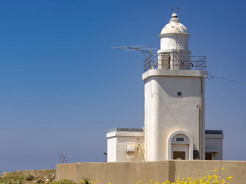
Date unknown (1920s?). Active; focal plane 246 m (807 ft); three flashes every 60 s, two white flashes followed 10 s later by a red flash. 16 m (52 ft) square concrete tower with lantern and gallery attached to a 1-story equipment room. 2nd order Fresnel lens in use. Entire lighthouse is white. A keeper's house, formerly attached, has been demolished. Chie Zō's 2020 photo is at the top of this page, the Coast Guard has a photo a 2022 photo and a distant view are available, and Google has a satellite view. Okino Shima is an isolated mountain peak emerging from the Sea of Japan roughly 70 km (45 mi) north northwest of Fukuoka and a similar distance west northwest of the Kanmon Strait. The lighthouse is perched atop the peak. The island is a shrine of the Shinto religion and is closed to women. Despite its remote location the island is attached administratively to Munakata City. Accessible only by helicopter or by boat in heavy seas. Site and tower closed. ARLHS JPN-485; JCG-5817; Admiralty M5076; NGA 12440.

Munakata City Lighthouses
* Ōshima (Chikusen Ōshima)
1926. Active; focal plane 51 m (167 ft); two white flashes every 15 s. 11 m (36 ft) square cylindrical concrete tower with lantern and gallery, attached to a 1-story concrete keeper's cottage. Entire lighthouse is white. A 2023 photo is at right, a 2021 photo, a 2018 photo and another photo are available, there's a street view from the base of the lighthouse, and Google has a satellite view. This light commands a spectacular view and is a popular tourist attraction. Ōshima ("Big Island," one of many islands of that name in Japan) is a roughly triangular island about 5 km (3 mi) in diameter and 8 km (5 mi) off the coast north of Fukuma. The island is accessible by ferry and most of it is included in a national park. Located at the northwestern tip of the island. Accessible by road. Site open, tower closed. . ARLHS JPN-648; JCG-5815; Admiralty M5288; NGA 12392.
* Ōshima East Breakwater (2)
1998 (station established 1981). Active; focal plane 11 m (36 ft); red flash every 3 s. 9 m (30 ft) concrete post rising from a square 1-story concrete equipment room. Entire lighthouse is red. Lighthouse Visits has a photo (last lighthouse on the page), Trabas has a distant view, the Coast Guard has a view from the sea, and Google has a satellite view. Located at the end of the east breakwater of Ōshima. Accessible by walking the pier, and there's a good view from arriving ferries. Site open, tower closed. JCG-5814; Admiralty M5289; NGA 12396.

Chikusen Ōshima Light, Munakata, May 2023
Google Maps photo by KAZU HOT
Kurara Se
Date unknown. Active; focal plane 28 m (92 ft); white flash every 3 s. 10 m (33 ft) round concrete tower with gallery. Entire lighthouse is white. Kenichiro Asai's 2022 photo is at right, a closer view is available, the Coast Guard has a photo, Trabas has a view from the sea, Our Lighthouses has a distant view, and Google has an indistinct satellite view. Kurara Se is an isolated giant rock, a smaller version of Eboshi Shima (see above). Located atop the rock about 4 km (2.5 mi) northeast of Ōshima. Accessible only by boat. Site and tower closed. ARLHS JPN-789; JCG-5810; Admiralty M5289.8; NGA 12404.
* Konominato Kō (Ku Saki, Ku Zaki)
1991. Active; focal plane 11 m (36 ft); red flash every 4 s. 8.5 m (28 ft) concrete post attached to a square 1-story concrete equipment room. Entire lighthouse is red. Trabas has a closeup photo, Our Lighthouses has a page with closeup photos, FOAL's page also has photos, and Google has a street view and a satellite view. Located at the end of the north breakwater of Konominato, the terminal for ferries to Aino Shima. Accessible by walking the pier. Site open, tower closed. ARLHS JPN-2013; JCG-5808; Admiralty M5290; NGA 12412.
* Kanesaki (Kanezaki) Kō
1975. Active; focal plane 12 m (39 ft); two green flashes every 6 s. 9.5 m (31 ft) concrete post attached to a square 1-story concrete equipment room. Entire lighthouse is white. Our Lighthouses has a page with a closeup photo and another photo of an older post on the same breakwater. Trabas has a closeup photo, FOAL's page also has photos, and Google has a satellite view and a distant street view across the harbor. Located at the end of the north breakwater of Kanesaki harbor. Accessible by walking the pier. Site open, tower closed. ARLHS JPN-2004; JCG-5807; Admiralty M5291; NGA 12408.

Okagaki Town Lighthouse
* Hatsu Kō (Hazu Kō, Hatsu Saki)
1977. Inactive since 2024. 9.5 m (31 ft) concrete post attached to a square 1-story concrete equipment room. Entire lighthouse is red. Trabas has a closeup photo, Our Lighthouses has a page with good photos, FOAL's page has good photos, and Google has a satellite view and a distant street view. The lighthouse may be removed. Located at the end of the north breakwater of Hatsu harbor in Okagaki. Accessible by walking the pier. Site open, tower closed. JCG-5806; ex-Admiralty M5291.4; NGA 12424.

Kurara Se Light, Munakata, January 2022
Google Maps photo by Kenichiro Asai

Ashiya Town Lighthouse
Ashiya Kō (Outer Breakwater)
Date unknown. Active; focal plane 13 m (43 ft); green flash every 3 s. 9.5 m (31 ft) concrete post attached to a square 1-story concrete equipment room. Entire lighthouse is white. Trabas has a photo, FOAL's page for the light has photos, and Google has a satellite view. Located at the west end of the detached breakwater of Ashiya harbor, at the mouth of the Onga River. Accessible only by boat. Site open, tower closed. JCG-5805.1; Admiralty M5291.55; NGA 12430.

Information available on lost lighthouses:

Notable faux lighthouses:

  • Nakagawa. This appears to be a traditional lighthouse, but it may be ornamental; we need information on its history. Located at the southern tip of Nakasu Island in the Naka River (Nakagawa) in the Hakata district of Fukuoka. Shuji Mitani has a street view and Google has a satellite view.

Adjoining pages: North: Western Yamaguchi | East: Kitakyūshū Area | West: Saga

Return to the Lighthouse Directory index | Ratings key

Posted June 25, 2007. Checked and revised June 13, 2024. Lighthouses: 27. Site copyright 2024 Russ Rowlett and the University of North Carolina at Chapel Hill.