Lighthouses of Japan: Toyama

The nation of Japan, known in Japanese as Nihon or Nippon (日本), occupies an archipelago off the east coast of Asia. The four main islands are Hokkaidō in the north, Honshū (the largest) in the center, Shikoku in the south, and Kyūshū in the southwest. The country includes thousands of other islands of all sizes; among them the Ryūkyū (Nansei) Islands are a long chain extending to the southwest and including the large island of Okinawa, and the Nanpō Islands are another long chain extending south into the Pacific Ocean. Much of Japan is mountainous but the coastal regions are densely populated and urbanized; the country's population is about 126 million.

Japan is divided into 47 prefectures. This page lists lighthouses of Toyama Prefecture on the western coast of Honshū. Toyama Prefecture faces north on Toyama Bay, a broad inlet of the Sea of Japan partially sheltered on the west by the mountainous Noto Peninsula in neighboring Ishikawa Prefecture. Unlike most Japanese coasts the coast of Toyama Bay is relatively low, with only a few rocky promontories.

In Japanese the word for a lighthouse is tōdai or toudai (灯台). The words saki and misaki are for capes and headlands, hana ("nose") is a promontory, hantō is a peninsula, shima (also spelled sima or jima) is an island, bae is a reef, iwa or shi is a rocky reef, amase or se is a shoal, wan is a bay, nada is a sound or basin, kaikyō is a strait, kawa is a river, and or minato is a harbor.

Lighthouses in Japan are operated and maintained by the Japanese Coast Guard's Maritime Safety Agency. On Honshū there is at least one Coast Guard Section Office in each prefecture, often two or more. Toyama Prefecture has a single office at Fushiki.

A note on the Sea of Japan/East Sea controversy: The Directory takes no side in any international dispute; it makes use of the terminology, names, and spellings as they currently exist in each area covered. The sea between Japan and Korea is called the Sea of Japan on the pages for Japan and the East Sea on the pages for Korea.

ARLHS numbers are from the ARLHS World List of Lights. JCG numbers are the Japanese Coast Guard's light list numbers. Admiralty numbers are from volume M of the Admiralty List of Lights & Fog Signals. U.S. NGA List numbers are from Publication 112.

General Sources
Lighthouses in Japan - Toyama
A comprehensive site covering the major lighthouses.
Lighthouse-Japan.com - Toyama
Excellent photos with notes (in Japanese) for most of the lighthouses.
Form of a Lighthouse - Toyama
Another site with many photos of Japanese lighthouses; this source is cited below as FOAL.
Lighthouse Visit
Another good source of lighthouse photos.
Online List of Lights - Japan
Photos by various photographers posted by Alexander Trabas.
Misty's Japanese Lighthouse Tour - Toyama
Photos and a few notes for lighthouses in all parts of the country.
Lighthouses in Toyama Prefecture
Photos by various photographers available from Wikimedia.
World of Lighthouses - Japan
Photos by various photographers available from Lightphotos.net.
Ninth Region Lighthouse Location Map
This interactive map links to photos and descriptions (in Japanese) of the major lighthouses of the Ninth Coast Guard Region, including Ishikawa, Toyama, and Niigata Prefectures.
Navionics Charts
Navigation chart for western Honshū.


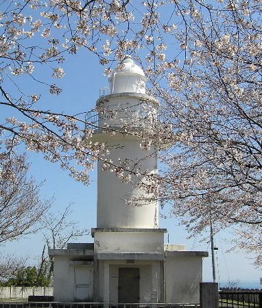
Iwasaki No Hana Light, Takaoka, April 2012
Japanese Coast Guard Fushiki Office photo (no longer online)
Himi City Lighthouses
* Himi Kō North Breakwater
Date unknown (station established 1939). Active; focal plane 12 m (39 ft); red flash every 5 s. 11 m (36 ft) concrete post attached to a square 1-story concrete equipment shelter. Entire lighthouse is red. FOAL has additional photos, Lighthouse Visit has photos, Trabas has a closeup photo, Matsumoto-pota Masa has a 2017 photo, a 2022 photo is available, and Google has a satellite view. Google also has a very distant street view taken from the harbor bridge. A March 2015 photo shows the light and, in the distance, the snow-capped Hida Mountains (sometimes called the Japanese Alps). Located at the end of the north breakwater at Himi, in the southwestern corner of Toyama Bay. Accessible by walking the pier. Site open, tower closed. ARLHS JPN-1282; JCG-1256; Admiralty M7166; NGA 3044.
Himi Kara Shima
Date unknown. Active; focal plane 20 m (66 ft); white flash every 3 s. 12 m (39 ft) concrete post attached to a square 1-story concrete equipment shelter. Entire lighthouse is white. Trabas has aa distant view, FOAL has distant views (at the bottom of the page), and Google has a satellite view. Located on an islet off Himi harbor. Accessible only by boat. Site status unknown. ARLHS JPN-1283; JCG-1255; Admiralty M7164.5; NGA 3052.

Takaoka City (Fushiki Harbor) Lighthouses
* Iwasaki No Hana
1951. Active; focal plane 58 m (190 ft); white flash every 15 s. 14 m (46 ft) round cylindrical concrete tower with lantern and gallery, rising from a rectangular 1-story equipment building. Entire lighthouse is white. 5th order clamshell Fresnel lens. A Coast Guard photo is at the top of this page, the Lighthouses of Japan site has a page for the lighthouse, Lighthouse-Japan.com has a page with several photos, FOAL has photos (halfway down the page), a 2022 photo is available, Misty's Tour has additional photos, Lightphotos.net has a closeup photo, and Google has a satellite view of the station. A tree obstructs Google's street view. Located on a promontory about 3 km (2 mi) northwest of the entrance to Fushiki (Takaoka) harbor. Accessible by road; limited parking available and the entrance to the access road is not well marked. Site open, tower closed. . ARLHS JPN-191; JCG-1258; Admiralty M7160; NGA 3056.
* Fushiki-Tyuo (East Breakwater)
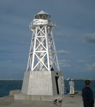
1999. Active; focal plane 12 m (39 ft); two green flashes every 5 s. 7 m (23 ft) hexagonal pyramidal skeletal tower with lantern and gallery, painted white, mounted on a hexagonal 1-story concrete equipment room. A Coast Guard photo is at right, a 2017 photo is available, Lighthouse-Japan.com has a page with good photos, FOAL's page has several photos, and Google has a street view and a satellite view. This unusual lighthouse is a replica of an 1877 wood lighthouse, the first to be built in this area of Japan. Located at the end of the breakwater of the traditional fishing harbor of Fushiki, just west of the modern industrial harbor. Site and tower closed but the lighthouse is easy to see from the waterfront. . JCG-1262.5; Admiralty M7162.3; NGA 3065.

Fushiki East Breakwater Light, Takaoka
Japanese Coast Guard photo
Fushiki Outer Breakwater Southeast Head
Date unknown. Active; focal plane 13 m (43 ft); two red flashes every 5 s. 10 m (33 ft) round concrete tower with a flared top, attached to a small equipment shelter. Entire lighthouse is red. FOAL has additional photos (halfway down the page), and Google has a satellite view. Located at the east end of the detached outer breakwater. Accessible only by boat. Site and tower closed. JCG-1263.41; Admiralty M7162.2; NGA 3066.
* Fushiki Kō East Breakwater
1962. Active; focal plane 12 m (39 ft); green flash every 4 s. 10 m (33 ft) concrete post attached to a square 1-story concrete equipment shelter. Entire lighthouse is white. FOAL's page has several photos, Lighthouse Visit has a photo, a 2021 photo is available, and Google has a satellite view and a distant street view. Located at the end of the jetty on the east side of the entrance to the Oyabegawa River in Fushiki. Accessible by walking the pier. Site open, tower closed. ARLHS JPN-1281; JCG-1267; Admiralty M7160.92; NGA 3068.
* Fushiki Kō (Leading Light)
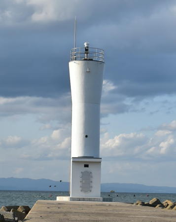
1979. Active; focal plane 20 m (66 ft); continuous light, red, green or white depending on direction, visible only on or near the proper line of approach.; also a general purpose light, yellow flash every 4 s. 18 m (59 ft) round cylindrical white concrete tower with gallery; the lights are shown through windows at the top of the tower. Akio Hayamoto's photo is at right, Shigeru Takabatake has a 2022 closeup photo, a 2017 closeup photo is available, FOAL has a photo (next to last photo on the page), and Google has a street view and a satellite view. This light leads vessels between shoals northeast of the harbor. Located at the water's edge on the east side of Fushiki harbor. Site open, tower closed. . ARLHS JPN-1280; JCG-1266; Admiralty M7161.3; NGA 3076.
 

Fushiki Kō Leading Light, Fushiki, February 2022
Instagram photo by Akio Hayamoto

Imizu City (Shinminato Harbor) Lighthouses
* Shinminato Gyoko West Breakwater
Date unknown (station established 1938). Active; focal plane 10 m (33 ft); two red flashes every 7 s. 8.5 m (28 ft) concrete post attached to a square 1-story concrete equipment shelter. Entire lighthouse is red. A 2017 closeup photo is available, FOAL has a photo (next to last row, left), and Google has a satellite view and a distant street view. NGA has an incorrect Admiralty number for this light. Located at the end of the west breakwater of the traditional Shinminato harbor, now a small boat harbor. Accessible by walking the pier. Site open, tower closed. JCG-1268; Admiralty M7151.9; NGA 3080.
Shinminato (Sinmanato) Gyoko East (Outer) Breakwater
Date unknown. Active; focal plane 14 m (46 ft); green flash every 3 s. 9 m (30 ft) concrete post attached to a square 1-story concrete equipment shelter. Entire lighthouse is white. FOAL has additional photos (top of the page) and Google has a satellite view and a very distant street view across the harbor. It's not clear why the Admiralty calls this the Outer Breakwater. Located at the end of the east breakwater of the traditional Shinminato harbor. Site status unknown. JCG-1270.3; Admiralty M7151.8; NGA 3090.
* Shinminato (Toyama Sinko) West Breakwater
1967. Active; focal plane 16 m (52 ft); two red flashes every 6 s. 15 m (49 ft) round concrete tower with lantern and gallery. Entire lighthouse is red. A 2018 photo and a 2006 photo are available, FOAL has a closeup photo (bottom of the page), and Google has a satellite view. This lighthouse stands adjacent to a park that includes the berth of the retired tall ship Kaiō-Maru, Japan's cadet training ship from 1930 to 1989. Google has a street view showing the ship and the breakwater lighthouses in the distance. Located at the end of a short breakwater pier. Site and tower closed (a fence prevents walking the pier), but the lighthouse is easily seen from the park. ARLHS JPN-1295; JCG-1275; Admiralty M7151.4; NGA 3092.
* Shinminato (Toyama Sinko) East Breakwater
1967. Active; focal plane 16 m (52 ft); two green flashes every 6 s. 15 m (49 ft) round concrete tower with lantern and gallery. Entire lighthouse is white. A photo is at right, FOAL has a closeup photo (bottom of the page), Shinnosuke Fujii has the view along the breakwater, and Google has a satellite view. Located at the end of the east (main) breakwater pier of the new Shinminato harbor. Accessible by walking the pier. Site open, tower closed. ARLHS JPN-1294; JCG-1274; Admiralty M7151; NGA 3096.

Toyama Sinko East Breakwater Light, Imizu, June 2008
ex-Panoramio Creative Commons photo by Axis

Toyama City Lighthouses
* Toyama Kō West Breakwater
1957. Active; focal plane 11 m (36 ft); two red flashes every 10 s. 10 m (33 ft) round concrete tower attached to a 1-story concrete equipment shelter. Entire lighthouse is red. FOAL has a good photo (bottom of the page) and Google has a satellite view and a closeup street view. Located on the breakwater on the west side of the entrance to the main harbor basin of Toyama city. Accessible by walking the pier. Site open, tower closed. ARLHS JPN-1292; JCG-1280; Admiralty M7149; NGA 3112.
* Toyama Kō East Breakwater (2)
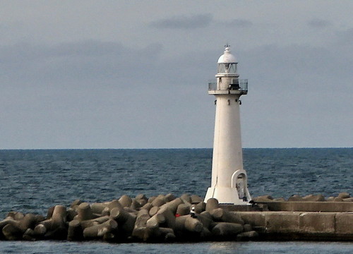
2020 (station established 1935). Active; focal plane 13 m (43 ft); two green flashes every 5 s. 10 m (33 ft) round concrete tower with a flared top. Entire lighthouse is white. Kimihiro Hashimoto's 2020 photo is at right. Sadly, this light replaced a historic 10 m (33 ft) round concrete tower with lantern and gallery. FOAL has photos, Masatika Hinata has a photo of the original lighthouse in action, and Google has a satellite view and a closeup street view. Located at the end of the east breakwater pier of the main harbor basin of Toyama city. Accessible by walking the pier. Site open, tower closed. ARLHS JPN-1293; JCG-1281; Admiralty M7148; NGA 3108.
* Mizuhashi Kō
1992. Active; focal plane 12 m (39 ft); green flash every 3 s. 10 m (33 ft) concrete post attached to a square 1-story concrete equipment shelter. Entire lighthouse is white. Matsumoto-pota Masa has a photo, FOAL's page for the lighthouse has two photos, and Google has a street view and a satellite view. Located at the end of the east (outer) breakwater at Mizuhashi, at the east end of the Toyama city waterfront. Accessible by walking the pier. Site open, tower closed. ARLHS JPN-1289; JCG-1282; Admiralty M7147; NGA 3116.

Namerikawa City Lighthouse
* Namerikawa Kō
1957. Active; focal plane 13 m (43 ft); two green flashes every 6 s. 10 m (33 ft) concrete post attached to a square 1-story concrete equipment shelter. Entire lighthouse is white. A 2017 photo is available, Matsumoto-pota Masa has a photo, FOAL's page has several photos, and Google has a satellite view and a distant street view. Located at the end of a pier on the north side of the entrance to the small boat harbor at Namerikawa, northeast of Toyama. Accessible by walking the pier. Site open, tower closed. ARLHS JPN-1290; JCG-1283; Admiralty M7145; NGA 3120.

Toyama Kō East Breakwater Light, Toyama, October 2020
ex-Google Maps photo by Kimihiro Hashimoto

Uozu City Lighthouses
* Uozu North Auxiliary Breakwater
1984. Active; focal plane 12 m (39 ft); two green flashes every 5 s. 9.5 m (31 ft) concrete post attached to a square 1-story concrete equipment shelter. Entire lighthouse is white. A 2018 closeup photo is available, FOAL has additional photos, and Google has a street view and a satellite view. Located at the end of an auxiliary breakwater at Uozu, south of the traditional harbor. Accessible by walking the pier. Site open, tower closed. ARLHS JPN-1297; JCG-1286; Admiralty M7144.4; NGA 3124.
* Uozu North Breakwater
Date unknown (station established 1938). Active; focal plane 13 m (43 ft); green flash every 4 s. 9.5 m (31 ft) concrete post attached to a square 1-story concrete equipment shelter. Entire lighthouse is white. A 2018 photo is available, FOAL has additional photos, and Google has a street view and a satellite view. Located at the end of the north breakwater at Uozu. Accessible by walking the pier. Site open, tower closed. ARLHS JPN-1298; JCG-1284; Admiralty M7142; NGA 3132.
* Kyōden Kō
1960. Active; focal plane 13 m (43 ft); two green flashes every 7 s. 10 m (33 ft) concrete post attached to a square 1-story concrete equipment shelter. Entire lighthouse is white. A 2018 photo is available, FOAL's page for the light has several photos, and Google has a street view and a satellite view. Located at the end of the breakwater at a small boat harbor on the north side of Uozu. Accessible by walking the pier. Site open, tower closed. JCG-1288; Admiralty M7137.6; NGA 3140.

Kurobe City Lighthouses
* Kurobe Kō
1962. Active; focal plane 13 m (43 ft); continuous green light with one brighter flash every 5 s. 10 m (33 ft) round cylindrical concrete tower with gallery. Lighthouse painted white, except a pattern of red flames is painted around the top of the tower. The lighthouse is designed to resemble torches used in a Shinto ritual that is performed once a year for the safety of sailors. Yukihiro Matsumura's 2022 photo is at right, a 2018 photo is available, Lighthouse-Japan.com has a page with several good photos, FOAL's page for the light has several photos, and Google has a street view and a satellite view. Located at the end of the breakwater of Kurobe; apparently accessible by walking the pier. Site open, tower closed. . ARLHS JPN-1286; JCG-1289; Admiralty M7137.2; NGA 3144.

Kurobe Light, Kurobe, August 2022
Instagram photo by Yukihiro Matsumura
* Ikuji (Ikuzi) Hana
1951. Active; focal plane 32 m (105 ft); white flash every 10 s. 30.5 m (100 ft) round cylindrical concrete tower with lantern and gallery, painted with black and white horizontal bands (an unusual daymark for a Japanese lighthouse). A photo is at right, Masahiro Ito has a 2017 photo, Lighthouses of Japan has a page with two good photos, Lighthouse-Japan.com has a page with several excellent photos, FOAL's page has good photos, a 2023 closeup is available, and Google has a closeup street view and a satellite view. This lighthouse marks the eastern entrance to Toyama Bay. Located on a cape on the north side of Kurobe. Site open, tower closed. . ARLHS JPN-161; JCG-1290; Admiralty M7137; NGA 3148.

Asahi Town Lighthouse
Miyazaki Hana
1959. Active; focal plane 108 m (354 ft); two white flashes every 11 s. 12 m (39 ft) round cylindrical concrete tower with lantern and gallery. Entire lighthouse is white. The tower also carries a continuous white spotlight (JCG-1292.5) illuminating a nearby reef. Lighthouse-Japan.com has a page with several photos, FOAL's page has closeup photos, and Google has a satellite view. Located on a forested height above Miyazaki, a village about 7 km (4.5 mi) east of Nyuzen. Site status unknown. . ARLHS JPN-367; JCG-1292; Admiralty M7136.7; NGA 3156.

Information available on lost lighthouses:

Notable faux lighthouses:


Ikuji Hana Light, Kurobe, October 2020
Instagram photo by todai_oshiro

Adjoining pages: North: Niigata | South: Northern Ishikawa

Return to the Lighthouse Directory index | Ratings key

Posted April 2, 2007. Checked and revised January 3, 2024. Lighthouses: 21. Site copyright 2024 Russ Rowlett and the University of North Carolina at Chapel Hill.