Lighthouses of Japan: Iki Shima

The nation of Japan, known in Japanese as Nihon or Nippon (日本), occupies an archipelago off the east coast of Asia. The four main islands are Hokkaidō in the north, Honshū (the largest), Shikoku in the south, and Kyūshū in the southwest. The country includes thousands of other islands of all sizes; among them the Ryūkyū (Nansei) Islands are a long chain extending to the southwest and including the large island of Okinawa, and the Nanpō Islands are another long chain extending south into the Pacific Ocean. Much of Japan is mountainous but the coastal regions are densely populated and urbanized; the country's population is about 126 million.

Japan is divided into 47 prefectures. Nagasaki Prefecture occupies the western side of the island of Kyūshū and includes many islands offshore in the East China Sea and Korea Strait. This page includes lighthouses of Iki Shima, an island in the Tsushima Strait about 32 km (20 mi) north of the city of Matsuura and about 18 km (11 mi) northwest of Hadano Misaki in Saga Prefecture. The island is about 20 km by 15 km (13 by 9 mi) and is accessible by air or by ferry from Fukuoka. The island is governed as a city within Nagasaki Prefecture, although it is somewhat closer to Saga Prefecture on the mainland of Kyūshū.

In Japanese, the word for a lighthouse is tōdai or toudai (灯台). The words saki and misaki are for capes and headlands, hana ("nose") is a promontory, hantō is a peninsula, shima (also spelled sima or jima) is an island, bae is a reef, iwa or shi is a rocky reef, amase or se is a shoal, wan is a bay, nada is a sound or basin, kaikyō is a strait, kawa is a river, and or minato is a harbor.

Lighthouses in Japan are operated and maintained by the Japanese Coast Guard's Maritime Safety Agency. There is at least one Coast Guard Section Office in each prefecture, often two or more. Although Iki Shima is in Nagasaki Prefecture its lighthouses are maintained by the Karatsu Office in neighboring Saga Prefecture.

ARLHS numbers are from the ARLHS World List of Lights. JCG numbers are the Japanese Coast Guard's light list numbers. Admiralty numbers are from volume M of the Admiralty List of Lights & Fog Signals. U.S. NGA List numbers are from Publication 112.

General Sources
Lighthouses in Japan - Nagasaki
This site covers most of the major Japanese lighthouses.
Our Lighthouses of Nagasaki Prefecture
A comprehensive collection of photos of Nagasaki lighthouses.
Form of a Lighthouse - Nagasaki
Another site with many photos of Japanese lighthouses, cited below as FOAL.
Lighthouse Visits
This site has photos for many lighthouses in this area.
Lighthouse-Japan.com - Nagasaki
This site has good photos and background information for more than a dozen Nagasaki area lighthouses.
Misty's Japanese Lighthouse Tour - Nagasaki
This web site has photos of several Nagasaki area lighthouses.
Lighthouses in Nagasaki Prefecture
Photos by various photographers available from Wikimedia.
Online List of Lights - Japan
Photos by various photographers posted by Alexander Trabas.
Navionics Charts
Navigation chart for Iki Shima.

Wakamiya Shima Light, Iki Shima
Japanese Coast Guard Fukuoka Office photo
Southwest Coast (Gōnoura Area) Lighthouses
Iki Gono Se (Go Se)
Date unknown. Active; focal plane 11 m (36 ft); white flash every 3 s. 7.5 m (25 ft) concrete post attached to a 1-story concrete equipment room. Entire lighthouse is white. A view from the sea is available, there's a distant photo (halfway down the page, #5932.5), and Google has a satellite view and a distant street view. Located off the south coast of Iki Shima at the start of the approach to Gōnoura. Accessible only by boat. ARLHS JPN-802; JCG-5932.5; Admiralty M5261.8; NGA 12698.
Gōnoura Kō Outer Breakwater
Date unknown. Active; focal plane 13 m (43 ft); red flash every 3 s. Approx. 9 m (30 ft) round concrete tower with a flared top attached to a 1-story concrete equipment room. Entire lighthouse is red. A closeup 2019 photo is available and Google has a satellite view. Gōnoura (misspelled Gonovra by NGA) is the terminal for ferries linking Iki Shima to the mainland of Kyūshū. Located at the north end of a detached breakwater of Gōnoura harbor, on the south coast of Iki Shima. Accessible only by boat, but there's a good view from the ferries. Site status unknown. JCG-5933.8; Admiralty M5259.27; NGA 12689.
* Gōnoura Kō Inner (North) Breakwater
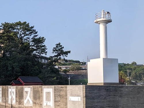
Date unknown. Active; focal plane 14 m (46 ft); continuous green light with a more intense flash every 3 s. 9.5 m (31 ft) concrete post attached to a 1-story concrete equipment room. Entire lighthouse is white. Masaaki Ito's photo is at right, Tatsuya Fukuyama has a closeup 2017 photo, and Google has a satellite view. Located at the end of a west inner breakwater of Gōnoura harbor. Accessible by walking the pier. Site open, tower closed. JCG-5934; Admiralty M5259.25; NGA 12688.
Naga Shima (Iki Nagashima)
Date unknown. Active; focal plane 49 m (161 ft); white flash every 4 s. 8 m (26 ft) square concrete tower atached to a small concrete equipment building. Entire lighthouse is white. A photo is available (#5935, halfway down the page) and Google has a street view and a satellite view. Located on an island off the southwestern tip of Iki Shima. Accessible only by boat. Site status unknown. ARLHS JPN-160; JCG-5935; Admiralty M5259; NGA 12624.

Inner Breakwater Light, Gōnoura, June 2022
Google Maps photo by Masaaki Ito
Funori (Hunori) Se
Date unknown. Active; focal plane 13 m (43 ft); red flash every 4 s. 12 m (39 ft) round concrete tower with an expanded top. Entire lighthouse is red. A photo is available (#5936.5, halfway down the page) and Google has a satellite view. Located on a reef off the north side of Iō Shima, an island off the southwestern tip of Iki Shima. Accessible only by boat. Site open, tower closed. JCG-5936.5; Admiralty M5259.32; NGA 12630.
Iki O Se (U Se)
Date unknown. Active; focal plane 14 m (46 ft); two white flashes every 6 s. 8.5 m (28 ft) round hourglass-shaped concrete tower. Entire lighthouse is white. A photo is available (#5937, a little over halfway down the page), and Google has a satellite view and a distant street view. Located just off the mainland of Iki Shima opposite the Funori Se light. Accessible only by boat. Site open, tower closed. JCG-5937; Admiralty M5259.34; NGA 12632.

North Coast (Katsumoto Area) Lighthouses
Tanega Shima
Date unknown. Active; focal plane 22 m (72 ft); white flash every 3 s. 9 m (30 ft) concrete post attached to a 1-story concrete equipment room. Entire lighthouse is white. A photo is available (#5939, a little less than halfway down the page) and Google has an indistinct satellite view. Located at the north end of an island just off the northwestern coast of Iki Shima. Accessible only by boat. Site open, tower closed. JCG-5939; Admiralty M5259.38; NGA 12636.
Wakamiya Shima
Date unknown. Active; focal plane 106 m (348 ft); white light occulting once every 8 s. 10 m (33 ft) octagonal stone tower with lantern and gallery. Entire lighthouse painted white. Several large communications towers are located at the station, as seen in the Coast Guard photo at the top of this page. A photo is available, amateur radio operator JA3PUA has posted a QSL card photo, and Google has a satellite view. Information is needed on this historic lighthouse. Located on an island off the northern tip of Iki Shima. Accessible only by boat. Site status unknown. ARLHS JPN-737; JCG-5940; Admiralty M5260; NGA 12640.
Katsumoto Kō Outer Breakwater
Date unknown. Active; focal plane 15 m (49 ft); green flash every 3 s. 11 m (36 ft) round concrete tower with a flared top, attached to a small equipment shelter. Entire lighthouse is white. Ken Sawa has a 2022 photo and Google has a satellite view. Located at the south end of a detached outer breakwater at the western entrance to Katsumoto, the fishing port at the northern tip of Iki Shima. Accessible only by boat. Site open, tower closed. ARLHS JPN-2202; JCG-5939.7; Admiralty M5259.45; NGA 12638.
Katsumoto Range Rear
Date unknown. Active; focal plane 24 m (79 ft); continuous yellow light. 9.5 m (31 ft) round concrete tower rising from a 1-story equipment building. The tower carries an arrowhead-shaped daymark, pointing up. A photo (#5942, a little over 1/3 the way down the page) is available, there's a distant photo (1/3 the way down the page) of the two range lights, and Google has a satellite view. The front light (JCG-5941) is on an 11 m (36 ft) concrete post. Located on the southeastern corner of Wakamiya Shima. Accessible only by boat. Site status unknown. ARLHS JPN-2200; JCG-5942; Admiralty M5259.61; NGA 12648.
* Katsumoto Kō West Breakwater
Date unknown. Active; focal plane 12 m (39 ft); red flash every 3 s. 8.5 m (28 ft) concrete post attached to a square equipment shelter. Entire lighthouse is red. Shō Harada's photo is at right, another closeup photo is available, and Google has a street view and a satellite view. Located on the west breakwater of Katsumoto harbor. Accessible by walking the pier. Site open, tower closed. ARLHS JPN-2201; JCG-5943; Admiralty M5259.4; NGA 12660.

West Breakwater Light, Katsumoto, August 2018
Google Maps photo by Shō Harada
* Uotsuri (Uoturi) Saki
1963. Active; focal plane 58 m (190 ft); white flash every 4 s. 8.5 m (28 ft) round concrete tower attached to a 1-story concrete equipment room. Entire lighthouse is white. Toru Nishioka's photo is at right, Lighthouse Visits has a page with photos, and Google has a street view and a satellite view. Located on a bluff above the northeastern point of Iki Shima. Site open, tower closed. ARLHS JPN-719; JCG-5946; Admiralty M5260.4; NGA 12664.

East Coast (Ashibe Area) Lighthouses
* Ebisu Kō
Date unknown. Active; focal plane 13 m (43 ft); red flash every 3 s; also a continuous white spotlight (JCG-5946.81) illuminates the south breakwater on the opposite side of the entrance. Approx. 10 m (33 ft) concrete post attached to a 1-story concrete equipment room. Entire lighthouse is red. The Coast Guard has a small photo (fourth photo on the page), and Google has a street view and a satellite view. Located on the east breakwater of Ebisu harbor, on north side of Ashibe. Accessible by walking the pier. Site open, tower closed. JCG-5946.8; Admiralty M5260.8; ex-NGA 12670.
Ashibe (Asibe) Kō Outer Breakwater
Date unknown. Active; focal plane 16 m (52 ft); red flash every 4 s. 11 m (36 ft) round concrete tower with a flared top, attached to a small equipment shelter. Entire lighthouse is red. A 2019 photo is available and Google has a street view and a satellite view. Located on the south end of a short outer breakwater protecting the entrance to Ashibe harbor, a ferry port on the east coast of Iki Shima. Accessible only by boat. Site open, tower closed. ARLHS JPN-2162; JCG-5947.5; Admiralty M5261.3; NGA 12676.
* Ashibe (Asibe) Kō South Breakwater
Date unknown. Active; focal plane 13 m (43 ft); green light, 2 s on, 2 s off. 9.5 m (31 ft) concrete post attached to a 1-story concrete equipment room. Entire lighthouse is white. A 2020 closeup photo is available, Coast Guard has a small photo (second photo on the page) and Google has a street view and a satellite view. Located on the south breakwater of Ashibe harbor, on the east coast of Iki Shima. Accessible by walking the pier. Site open, tower closed. ARLHS JPN-2160; JCG-5948; Admiralty M5261.4; NGA 12672.
#Ashibe (Asibe) Kō (2)
Date unknown (station established 1916). Removed in 2017. 8.5 m (28 ft) concrete post attached to a 1-story concrete equipment room. Entire lighthouse is white. A January 2017 closeup photo is available but Google's satellite view confirms the removal. The light was deactivated in August 2017. Located on a bluff above the south side of the entrance to Ashibe. Site open, tower closed. ARLHS JPN-027; ex-JCG-5949; ex-Admiralty M5261; ex-NGA 12668.

Uotsuri Saki Light, Katsumoto, June 2021
Google Maps photo by Toru Nishioka

Southeast Coast (Ishidacho Area) Lighthouses
Kanashiro Iwa
Date unknown. Active; focal plane 22 m (72 ft); white flash every 3 s. 10 m (33 ft) round concrete tower flared at the op and conncted to a small 1-story equipment shelter. Entire lighthouse is white. Hiroto Tsuda has a photo, another photo is available (#5951, a little less than halfway down the page), Trabas has a very distant view and Bing has a distant satellite view. Located on a small island about 1.6 km (1 mi) east of the southeastern tip of Iki Shima. Accessible only by boat. Site status unknown. JCG-5951; Admiralty M5261.45; NGA 12684.
Na Shima
Date unknown. Active; focal plane 32 m (105 ft); white flash every 5 s. 14 m (46 ft) concrete post attached to a 1-story concrete equipment room. Entire lighthouse is white. No closeup photo available, but Lighthouse Visits has distant views, Trabas has a very distant view, and Google has a satellite view. Located on a small island at the west end of a reef about 7 km (4 mi) east of the southeastern tip of Iki Shima. Accessible only by boat. Site status unknown. ARLHS JPN-811; JCG-5927; Admiralty M5261.9; NGA 12712.
Iki Oto Shima
Date unknown. Active; focal plane 14 m (46 ft); white light, 4 s on, 4 s off. 6.5 m (21 ft) round concrete tower attached to a small equipment shelter. Entire lighthouse is white. A photo is available (#5928, halfway down the page), there's a second photo, and Google has a satellite view and a distant street view. Located on an islet just off the southeastern tip of Iki Shima. Accessible only by boat. Site status unknown. ARLHS JPN-2255; JCG-5928; Admiralty M5261.5; NGA 12692.
Indoji Kō (West Breakwater)
Date unknown. Active; focal plane 11 m (36 ft); continuous green light with a more intense flash every 5 s. 8.5 m (28 ft) concrete post attached to a square concrete equipment room. Entire lighthouse is white. Google has a distant street view and a satellite view. Accessible only by boat. Located at the east end of the detached outer breakwater of Indoji harbor, on the southeastern coast of Iki Shima. ARLHS JPN-2191; JCG-5930.1; Admiralty M5261.71; NGA 12697.
* Iruka Saki
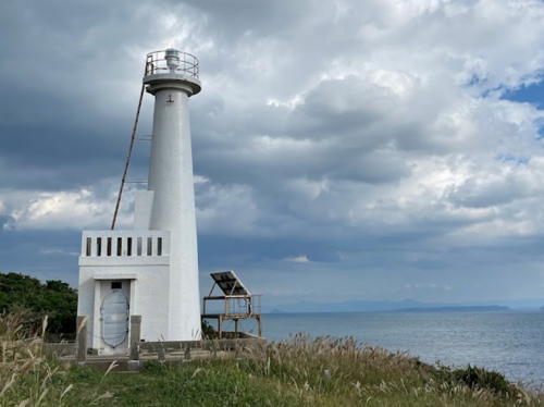
1967. Active; focal plane 31 m (102 ft); white light occulting twice every 6 s. 10 m (33 ft) round concrete tower attached to a small 1-story concrete equipment room. Entire lighthouse is white. Yuji Sawai's photo is at right, Lighthouse Visits has a page for the light, a 2017 closeup is available, Tatsuya Fukuyama has a closeup photo, and Google has a satellite view. Accessible by a short hike. Located on the southern tip of Iki Shima. Site open, tower closed. ARLHS JPN-177; JCG- 5932; Admiralty M5261.74; NGA 12700.

Iruka Saki Light, Iki Shima, October 2021
Google Maps photo by Yuji Sawai

Information available on lost lighthouses:

Notable faux lighthouses:

Adjoining pages: North: Tsushima | East: Saga | South: Nagasaki Area | West: Gotō Islands

Return to the Lighthouse Directory index | Ratings key

Posted August 6, 2007. Checked and revised May 29, 2024. Lighthouses: 21. Site copyright 2024 Russ Rowlett and the University of North Carolina at Chapel Hill.