Lighthouses of Japan: Nagasaki Area

The nation of Japan, known in Japanese as Nihon or Nippon (日本), occupies an archipelago off the east coast of Asia. The four main islands are Hokkaidō in the north, Honshū (the largest), Shikoku in the south, and Kyūshū in the southwest. The country includes thousands of other islands of all sizes; among them the Ryūkyū (Nansei) Islands are a long chain extending to the southwest and including the large island of Okinawa, and the Nanpō Islands are another long chain extending south into the Pacific Ocean. Much of Japan is mountainous but the coastal regions are densely populated and urbanized; the country's population is about 126 million.

Located at the southwestern end of the Japanese archipelago, the island of Kyūshū is divided into seven prefectures. Nagasaki Prefecture occupies the northwestern side of the island and includes many islands offshore in the East China Sea and Korea Strait. This page includes lighthouses of the southern part of the prefecture, including the city of Nagasaki itself, the Nomozaki Peninsula to the south, and the Shimabara Peninsula to the southeast. There are separate pages for the Sasebo area to the north, for the island of Tsushima halfway between Kyūshū and South Korea, for Iki Shima in the Tsushima Strait to the northeast, and for the Gotō Islands, an archipelago in the East China Sea west of Nagasaki City. All these territories are included in Nagasaki Prefecture.

In Japanese, the word for a lighthouse is tōdai or toudai (灯台). The words saki and misaki are for capes and headlands, hana ("nose") is a promontory, hantō is a peninsula, shima (also spelled sima or jima) is an island, bae is a reef, iwa or shi is a rocky reef, amase or se is a shoal, wan is a bay, nada is a sound or basin, kaikyō is a strait, kawa is a river, and or minato is a harbor.

Lighthouses in Japan are operated and maintained by the Japanese Coast Guard's Maritime Safety Agency. There is at least one Coast Guard Section Office in each prefecture, often two or more. Most of the lighthouses in the area covered by this page are maintained by the Coast Guard office in Nagasaki City but lighthouses of Ariake Bay are maintained by the office at Miike in Fukuoka Prefecture.

ARLHS numbers are from the ARLHS World List of Lights. JCG numbers are the Japanese Coast Guard's light list numbers. Admiralty numbers are from volume M of the Admiralty List of Lights & Fog Signals. U.S. NGA List numbers are from Publication 112.

General Sources
Lighthouses in Japan - Nagasaki
This site covers most of the major Japanese lighthouses.
Our Lighthouses of Nagasaki Prefecture
A comprehensive collection of photos of Nagasaki lighthouses.
Form of a Lighthouse - Nagasaki
Another site with many photos of Japanese lighthouses, cited below as FOAL.
Lighthouse Visits
This site has photos for many lighthouses in this area.
Lighthouse-Japan.com - Nagasaki
This site has good photos and background information for more than a dozen Nagasaki area lighthouses.
Misty's Japanese Lighthouse Tour - Nagasaki
This web site has photos of several Nagasaki area lighthouses.
Miike Area Lighthouses
Information and photos posted by the Miike Coast Guard Office.
Aids to Navigation Information Nagasaki
An interactive map leads to information and photos posted by the Nagasaki Coast Guard Office.
Lighthouses in Nagasaki Prefecture
Photos by various photographers available from Wikimedia.
Online List of Lights - Japan
Photos by various photographers posted by Alexander Trabas.
Navionics Charts
Navigational chart for Kyūshū.
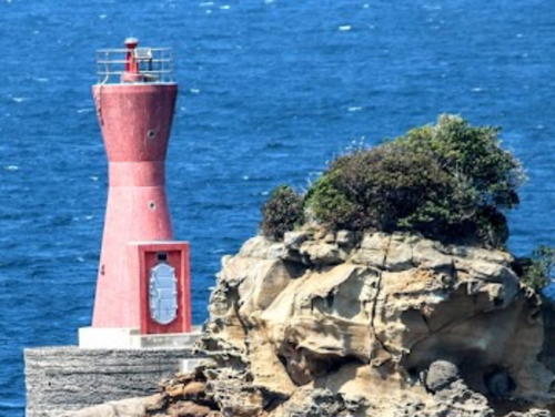
Kaba Shima Light, Nagasaki, May 2022
Google Maps photo by Takashi Kurokawa

Shimabara Peninsula Lighthouses

The Shimabara Peninsula separates Ariake Bay on the east from Tachibana Bay on the west. The peninsula is dominated by the dangerous Mount Unzen volcano, last active in 1990-95.

Unzen City North Coast (Ariake Bay) Lighthouse
Unzen spans the base of the Shimabara Peninsula with a north coast on Ariake Bay and a west coast on Tachibana Bay. Lighthouses of the west coast are listed below.

*
Kunimi Tahira Kō
1963. Active; focal plane 14 m (46 ft); continuous red light with a more intense flash every 5 s. 7.5 m (25 ft) concrete post attached to a 1-story concrete equipment room. Entire lighthouse is red. The Miike Coast Guard Office has a photo (#33 on the page), Trabas has a closeup photo, FOAL has photos (lower half of the page), Wanz Kogata has a 2023 photo, and Google has a street view and a satellite view. Located at the end of the west breakwater of Tahira harbor. Accessible by walking the pier, and there's a good view from ferries sailing between Tahira and Nagasu on the other side of Ariake Bay. Site open, tower closed. JCG-6385; Admiralty M5179.6; NGA 11620.

Shimabara City Lighthouses
Shimabara is a city of about 45,000 residents at the foot of Mount Unzen on the west side of Ariake Bay.
Shimabara Shinko Breakwater
1981. Active; focal plane 14 m (46 ft); green flash every 4 s. 9 m (30 ft) concrete post attached to a 1-story concrete equipment room. Entire lighthouse is white. The Miike Coast Guard Office has a photo (#36 on the page), Trabas has a closeup photo, FOAL has photos, and Google has a satellite view and a very distant street view. Located at the north end of a detached breakwater of a relatively new harbor developed for an industrial park on the north side of Shimabara. Accessible only by boat. Site status unknown. ARLHS JPN-2263; JCG-6384; Admiralty M5179.8; NGA 11568.
* Shimabara Kō
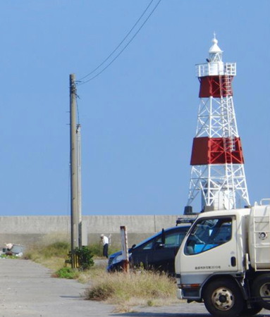
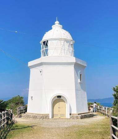
1910. Active; focal plane 19 m (62 ft); white flash every 4 s. 13 m (43 ft) square skeletal tower with lantern and gallery, mounted on a robust square concrete base. Lighthouse painted white, but two red daymarks are wrapped around three sides of the tower. A photo is at right, Our Lighthouses has a page with good photos, FOAL has excellent photos, the Miike Coast Guard Office has a photo (#37 on the page), Trabas has a good photo, a 2020 photo is available, and Google has a street view and a satellite view. This is a very unusual lighthouse design for Japan. Located on a reef just off the end of main quay at Shimabara, on the east side of the Shimabara Peninsula. Accessible only by boat, but there is an excellent view from the quay. Site open, tower closed. ARLHS JPN-2267; JCG-6382; Admiralty M5180; NGA 11572.
Shimabara Breakwater
1963. Active; focal plane 12 m (39 ft); two red flashes every 6 s. 8.5 m (28 ft) concrete post attached to a 1-story concrete equipment room. Entire lighthouse is red. The Miike Coast Guard Office has a photo (#39 on the page), Trabas has a photo, FOAL's page has photos, and Google has a satellite view. Located at the end of the main breakwater of the ferry harbor in Shimabara; ferries sail from here to Kumamoto on the other side of Ariake Bay. Site status unknown. JCG-6380; Admiralty M5181; NGA 11580.
Moso Se
1949. Active; focal plane 10 m (33 ft); one short and one long red flash every 8 s. 11 m (36 ft) round concrete tower with a large round equipment section. Entire lighthouse is red. The Miike Coast Guard Office has a photo (#38 on the page), FOAL's page has photos, Trabas has a closeup photo, a 2023 photo is available, and Google has a street view and a satellite view. Located on a shoal about 500 m (0.3 mi) southeast of the Shimabara Breakwater Light. Accessible only by boat but there is an excellent view from the Shimabara-Kumamoto ferries. Site open, tower closed. JCG-6379; Admiralty M5182; NGA 11576.

Shimabara Kō Light, Shimabara, October 2017
Twitter photo posted by @UnzenGioiko

Minamishimabara (South Shimabara) City Lighthouses
Minamishimabara (South Shimabara) a city of about 50,000 residents, occupies the southern end of the Shimabara Peninsula. Portuguese and Spanish traders and missionaries were active here in the 17th century.
Okino Se
Date unknown. Active; focal plane 14 m (46 ft); two white flashes every 5 s. 12 m (39 ft) round tower with a large round equipment section, painted black with a red horizontal band. The Miike Coast Guard Office has a photo (#49 on the page), Trabas has a photo, FOAL's page has photos (lower half of the page), and Google has a satellite view. This is the last lighthouse on the page maintained by the Miike Coast Guard Office. Located on a rock about 3 km (2 mi) east northeast of the entrance to Kuchinotsu harbor. Accessible only by boat. Site open, tower closed. JCG-6373; Admiralty M5184; NGA 11712.

The remaining lighthouses on this page are maintained by the Nagasaki Coast Guard Office.

* Kuchinotsu (Kutinotu)
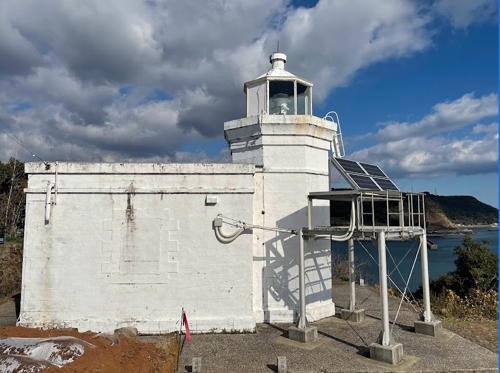
1880. Active; focal plane 40 m (131 ft); two white flashes every 7 s. 6 m (20 ft) octagonal cylindrical brick tower with lantern and gallery, attached to a 1-story brick keeper's cottage. Entire lighthouse painted white. 5th order Fresnel lens in use. Katsuhiko Fujita's photo is at right, the Coast Guard has a page for the light, Trabas has a good closeup photo, Lighthouse-Japan.com has a page for the lighthouse, Our Lighthouses has a page with many good photos, FOAL's page has photos, and Google has a street view and a satellite view. This is one of the few surviving brick lighthouses in Japan. This lighthouse and all subsequent lighthouses on the page are maintained by the Nagasaki Coast Guard Office. Located on a promontory overlooking the mouth of Ariake Bay and marking the entrance to Kuchinotsu harbor. Accessible by a single-lane road; limited parking is available at the end of the road. Site open, tower closed. . ARLHS JPN-318; JCG-6370; Admiralty M5186; NGA 11716.

Kuchinotsu Light, Minamishimabara, December 2021
Google Maps photo by Katsuhiko Fujita
* Setsume (Sezume) Saki
1966. Active; focal plane 13 m (43 ft); white light, 3 s on, 3 s off. 12 m (39 ft) round post with a broadly conical base, mounted on a concrete or stone pier at the end of a breakwater. Lighthouse-Japan.com has a closeup, the Coast Guard has a page with a photo, Trabas has a photo, FOAL's page has photos, and Google has a street view and a satellite view. Located at the extreme southwestern tip of the Shimabara peninsula. When the sea is calm one can reach the lighthouse by walking the narrow walkway (handrails have been added). Accessible by road but local guidance may be needed and no parking is provided. Site open, tower closed. . ARLHS JPN-553; JCG-6369; Admiralty M5187.3; NGA 11728.

Unzen City West Coast (Tachibana Bay) Lighthouses
* Shimabara Kunisaki
1998. Active; focal plane 15m (49 ft); white flash every 3 s. 12 m (39 ft) round cylindrical tower with gallery, attached to a small equipment shelter. Entire lighthouse is white. Junko Hirata has a 2009 photo, Our Lighthouses has a page with several photos, the Coast Guard has a page with a photo, FOAL's page has photos (halfway down the page), Trabas has an aerial view, and Google has a satellite view. Located at the tip of a spit sheltering the harbor of Minamikushiyama. Site open, tower closed. . ARLHS JPN-2268; JCG-6362.2; Admiralty M5187.55; NGA 11729.
Kyodomari Kō
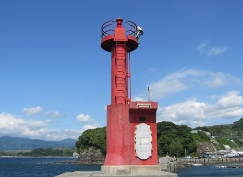
1970. Active; focal plane 12 m (39 ft); red light, 2 s on, 2 s off. 8 m (26 ft) concrete post attached to a 1-story concrete equipment room. Entire lighthouse is red. A Coast Guard photo is at right, Lighthouse-Japan.com has a page with a photo, Trabas has a photo, FOAL's page has photos (bottom of the page), and Google has a satellite view. Located on the west breakwater of the main (eastern) harbor of Minamikushiyama. Accessible by walking the pier. Site open, tower closed. JCG-6362; Admiralty M5187.4; NGA 11732.

Isahaya City Lighthouse
Syamisen Shima
Date unknown. Active; focal plane 15m (49 ft); one short and one long green flash every 8 s. 15 m (49 ft) round concrete tower with gallery, painted green. The Coast Guard's page has a photo, Trabas has a photo, FOAL has photos (halfway down the page), and Google has a satellite view. Located on a rock near the north shore of Tachibana Bay about 15 m (9 mi) east of Nagasaki. Accessible only by boat. Site open, tower closed. JCG-6361; Admiralty M5187.6; NGA 11736.
Kyodomari Light
Kyodomari Kō Light, Unzen
Japanese Coast Guard Nagasaki Office photo

Nagasaki City Lighthouses

The prefectural capital of Nagasaki ("Long Cape") is a city of more than 400,000 residents. It is a major port and a traditional ship-building center; beginning in the 17th century it was an area of Durch and Portuguese influence. The modern city has been rebuilt after being almost completely destroyed by the U.S. atomic bomb attack of 9 August 1945.

Mogi Harbor (Tachibana Bay) Lighthouses
* Mogi Kō East Breakwater
1976. Active; focal plane 13 m (43 ft); continuous green light with a more intense flash every 3 s. 8.5 m (28 ft) concrete post attached to a 1-story concrete equipment room. Entire lighthouse is white. The Coast Guard's page has a photo, FOAL has photos, Trabas has a closeup photo, and Google has a satellite view and a distant street view across the harbor. Located at the end of the main breakwater of Mogi harbor. Accessible by walking the pier. JCG-6360; Admiralty M5187.64; NGA 11752.
Mogi Kō Outer Breakwater
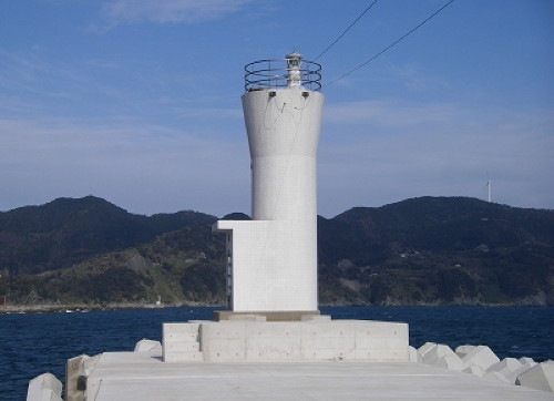
1990. Active; focal plane 14 m (46 ft); two green flashes every 6 s. 8.5 m (28 ft) round concrete tower, flared at the top, attached to a small equipment shelter. Entire lighthouse is white. The Coast Guard has a page for the light and the photo at right, FOAL has photos, Trabas has a closeup photo, and Google has a satellite view and a distant street view across the harbor. Located at the north end of the detached outer breakwater of Mogi harbor. Accessible only by boat, but there's a good view from ferries crossing Tachibana Bay to Amakusa Island. Site open, tower closed. ARLHS JPN-2230; JCG-6360.3; Admiralty M5187.67; NGA 11754.

Kaba Shima Area Lighthouses
The Nagasaki Peninsula, also called the Nomozaki or Nomo Peninsula, is a narrow, rugged peninsula extending southwestward south of the city center and ending in Nomozaki (Cape Nomo). Kaba Shima is an inhabited island just off the southeast side of the cape.

Wakimisaki Kō North Breakwater
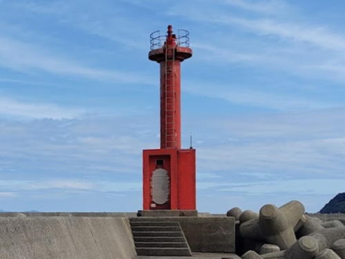
1964. Active; focal plane 13 m (43 ft); continuous red light with a more intense flash every 5 s. 9.5 m (31 ft) concrete post attached to a 1-story concrete equipment room. Entire lighthouse is red. A photo is at right, Coast Guard's page has a photo, Trabas has a photo, FOAL's page has a photo (top of the page), and Google has a satellite view and a distant street view across the harbor. Located at the end of the north inner breakwater of Wakimisaki harbor; this was formerly the terminal for ferries serving Kabashima. Accessible by walking the pier. JCG-6355; Admiralty M5188; NGA 11740.
Wakimisaki Kō Outer Breakwater North End
1983. Active; focal plane 14 m (46 ft); continuous green light with a more intense flash every 5 s. 9.5 m (31 ft) concrete post attached to a 1-story concrete equipment room. Entire lighthouse is white. The Coast Guard's page has a photo, Trabas has a photo, FOAL's page has a photo (top of the page), and Google has a satellite view and a distant street view. Since the linked photos were taken the breakwater has been extended and the light relocated to the new end point. Located at the north end of the outer breakwater of Wakimisaki harbor. Accessible only by boat. JCG-6357; Admiralty M5188.3; NGA 11744.
Wakimisaki Kō Outer Breakwater South End
1965. Active; focal plane 14 m (46 ft); red flash every 3 s. 9.5 m (31 ft) concrete post attached to a 1-story concrete equipment room. Entire lighthouse is red. The Coast Guard's page has a photo, Trabas has a photo, and Google has a satellite view. Located at the south end of the outer breakwater of Wakimisaki harbor. Accessible only by boat. JCG-6356; Admiralty M5189; NGA 11748.

Mogi Kō North Breakwater Light, Nagasaki, May 2023
Google Maps photo by Boombala Man
Kabashima Breakwater
1964. Active; focal plane 11 m (36 ft); continuous red light with two more intense flashes every 10 s. 8.5 m (28 ft) concrete post attached to a 1-story concrete equipment room. Entire lighthouse is red. The Coast Guard's page has a photo, Trabas has a photo, FOAL's page has photos (bottom of the page), a distant 2023 photo is available, and Google has a street view and a satellite view. Located at the end of a short pier at the northern tip of Kabashima, marking the west entrance to the strait separating the island from the mainland. Accessible by walking the pier. JCG-6354; Admiralty M5191; NGA 11756.
* Kabashima Kō
1988. Active; focal plane 13 m (43 ft); green light occulting once every 8 s. 8.5 m (28 ft) round concrete tower, flared at the top, attached to a small equipment shelter. Entire lighthouse is white. A Coast Guard photo is at right, Trabas has a photo, Kohei Ogawa has a 2019 photo, FOAL's page has photos (halfway down the page), and Google has a street view and a satellite view. Located at the end of the main breakwater of Kabashima harbor, at the northern tip of the island. Accessible by walking the pier. Site open, tower closed. JCG-6357.5; Admiralty M5191.4; NGA 11749.
* Kaba Shima
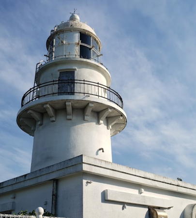
1932. Active; focal plane 126 m (413 ft); white flash every 20 s. 15 m (49 ft) round cylindrical concrete tower with lantern and gallery, attached to a 1-story concrete service building. Entire lighthouse is white. 2nd order clamshell Fresnel lens in use. Takashi Kurokawa's 2022 photo is at the top of this page, Wikimedia has a 2009 closeup photo, Our Lighthouses has a page with excellent photos, Lighthouse-Japan.com has a page for the lighthouse, FOAL has photos, the City of Nagasaki has a nice photo, Trabas has a closeup photo, Misty's Tour has additional photos, the Coast Guard's page has a photo, Taisuke Ogata has a street view, and Google has a satellite view. This attractive and popular lighthouse serves a landfall light for Nagasaki and also for Ariake Bay. The island, Kaba Shima, lies just off the tip of the Nomozaki Peninsula about 30 km (19 mi) south southwest of Nagasaki city. The island is accessible by a bridge. The light station area is a nature park. Located on the southern tip of the island. Accessible by a narrow, twisting approach road; parking is available at the lighthouse. Site open, tower closed. . ARLHS JPN-204; JCG-6352; Admiralty M5190; NGA 11760.
Kabashima Kō Light
Kabashima Kō Light, Nagasaki
Japanese Coast Guard Nagasaki Office photo

Nomozaki (Cape Nomo) Area Lighthouses
Ōtachigami (Otategami, Nomo Saki)
1971. Active; focal plane 27 m (89 ft); green flash every 3 s. 7 m (23 ft) round white concrete tower attached to a small equipment shelter. The Coast Guard's page has a photo, FOAL has photos, Trabas has a distant view, and Google has a satellite view. It's not clear how the Coast Guard accesses this light for service. Located atop a rocky pinnacle just off the tip of the Nomozaki Peninsula. Inaccessible, but there's a good view from the tip of the point. Site and tower closed. JCG-6351; Admiralty M5192; NGA 11764.
Mitsu (Mitu) Se
1971. Active; focal plane 26 m (85 ft); white flash every 5 s. 8.5 m (28 ft) concrete post attached to a 1-story concrete equipment room. Entire lighthouse is white. No closeup photo available. The Coast Guard's page has a view from the sea, Trabas has a view from the sea, FOAL has a distant view (second row of photos), and Bing has a distant satellite view. Located on an isolated and dangerous reef about 3.2 km (2 mi) northwest of the tip of the Nomozaki Peninsula. Accessible only by boat. Site open, tower closed. ARLHS JPN-2228; JCG-6346; Admiralty M5193.4; NGA 11780.
Nomokita Ura (Nomo Kitaura)
1952. Active; focal plane 41 m (135 ft); white light, 3 s on, 3 s off; also a continuous white spotlight (JCG-6348) illuminates a nearby rock. 12 m (39 ft) concrete post attached to a 1-story concrete equipment room. Entire lighthouse is white. FOAL's page has photos (3/4 the way down the page), Trabas has a distant view, and Google has a satellite view. Located on a promontory on the south side of the entrance to the fjord -like inlet forming the harbor of Nomokita, near the southwestern tip of the Nomozaki Peninsula. This lighthouse is quite difficult to find without local guidance. Site open, tower closed. ARLHS JPN-429; JCG-6347; Admiralty M5193; NGA 11768.
* Nomo Kō
1964. Active; focal plane 11 m (36 ft); continuous green light with a more intense flash every 6 s. 10 m (33 ft) concrete post attached to a 1-story concrete equipment room. Entire lighthouse is white. The Coast Guard's page has a photo, Trabas has a closeup photo, FOAL's page has photos, and Google has a street view and a satellite view. Located on the north side of the narrow entrance to the harbor at Nomokita. Accessible by walking the pier. Site open, tower closed. ARLHS JPN-2241; JCG-6349; Admiralty M5193.2; NGA 11772.

Nagasaki Harbor Lighthouses
Hizen Ha Shima (Hashima, Gunkan Shima)
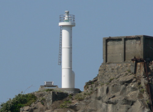
1975. Active; focal plane 50 m (164 ft); white flash every 3 s. 10 m (33 ft) round cylindrical tower attached to a small equipment shelter. Entire lighthouse is white. A photo is at right, Our Lighthouses has a distant view from the mainland, FOAL's page has distant views, Trabas has a distant view, and Google has a satellite view. Hashima is a small island about 6.5 km (4 mi) off the mainland and 25 km (15 mi) southwest of Nagasaki. A coal mine was operated on the island starting around 1800, and in the 20th century industrial facilities were added. During World War II the island was a labor camp, with the factories worked by prisoners from Korea and China. Mining and other activities continued after the war, but all the buildings are abandoned now. The island is often called Gunkan Shima (Warship Island), because the buildings resemble the superstructure of a warship at a distance. The lighthouse is near the southwestern tip of the island. Site and tower closed (access to the island is restricted because many of the buildings are in hazardous condition). ARLHS JPN-2179; JCG-6345; Admiralty M5193.42; NGA 11784.
Hashima Light
Hashima Light, Nagasaki, April 2009
Wikimedia Creative Commons photo by Hisagi (氷鷺)
Hizen Kuro Se
1968. Active; focal plane 15 m (49 ft); white flash every 3 s. 12.5 m (41 ft) round tapered concrete tower with a large round equipment section. Entire lighthouse is white. The Coast Guard's page has a photo, Trabas has a photo, FOAL has photos (bottom of the page), Eric Wong has a 2023 photo, and Google has a satellite view. Located on a rock about 700 m (0.45 mi) off the southern tip of Iō Shima. Accessible only by boat. Site open, tower closed. ARLHS JPN-2180; JCG-6344; Admiralty M5193.6; NGA 11788.
#Onaka Seto West
1971. Inactive since 2010 and removed in 2012. This was a 9.5 m (31 ft) concrete post attached to a 1-story concrete equipment room and mounted on a square concrete pier. Entire lighthouse was white. Google has a 2011 sea view taken from a passing ferry but Google's satellite view confirms the removal of the light. The light was deactivated after construction of a bridge joining Io Shima to the mainland made it unnecessary. Located just off the southeastern tip of Io Shima. Accessible with caution by a narrow bridge. Site open, tower closed. ARLHS JPN-2249; ex-JCG-6332; ex-Admiralty M5193.7; ex-NGA 11800.
*** Iō Shima (Iōjima) (3)
2003 (station established 1871). Active; focal plane 64 m (210 ft); four white flashes every 20 s. 11 m (36 ft) hexagonal concrete tower. Entire lighthouse painted white. The 1-story keeper's house and other light station buildings have been renovated as a lighthouse museum. The original Iō Shima lighthouse, designed by Richard Henry Brunton, was a hexagonal cast iron tower, the first cast iron lighthouse to be installed in Japan. This historic building was damaged beyond repair by the U.S. atomic bomb attack of 9 August 1945. It was replaced in 1954 by the square cylindrical concrete tower seen on the Lighthouses of Japan page and in the Misty's Tour photos taken in August 2001. In 2003 the lighthouse was either replaced or expanded to a hexagonal tower reproducing the shape and form of the 1871 original. Shigeaki Makino's 2022 photo of the reconstructed tower is at right, Our Lighthouses has a page with excellent photos, FOAL's page has numerous photos, Trabas has a closeup photo, N. Ichiro has a 2018 photo, Ikuo Nakamura has a 2017 street view, and Google has a satellite view. Iō Shima (Iōjima) is an island about 10 km (6 mi) southwest of Nagasaki; the island is accessible by ferry. Located at the northwestern tip of Iō Shima, commanding a sweeping view of the East China Sea. Site open, museum open daily except Mondays, tower closed. . ARLHS JPN-172; JCG-6330; Admiralty M5194; NGA 11792.
Hira Se (2?)
Date unknown (station established 1880). Active; focal plane 17 m (56 ft); two white flashes every 5 s. 14 m (46 ft) round tapered concrete tower with a large round equipment section, painted black with one red horizontal band. The Coast Guard's page has a closeup photo, Trabas has a photo, FOAL has photos, and Google has a good satellite view. Located on a reef about 2 km (1.2 mi) off the northeast coast of Iō Shima. Accessible only by boat. Site open, tower closed. JCG-6331; Admiralty M5195; NGA 11796.

Iō Shima Light, Nagasaki, October 2022
Google Maps photo by Shigeaki Makino
Onaka Seto North
1969. Active; focal plane 14 m (46 ft); two green flashes every 6 s. 8.5 m (28 ft) round concrete tower, flared at the top, attached to a small equipment shelter. Entire lighthouse is red. a 2020 photo is at right, the Coast Guard has a page, Trabas has a closeup photo, FOAL has photos (top of the page), and Google has a satellite view and a sea view taken from a passing ferry. NGA and the Admiralty formerly described the tower as white, but probably it has always been red. Located on a reef at the north end of the strait separating Io Shima from the Onaka Seto Peninsula of the mainland. Site status unknown. ARLHS JPN-2248; JCG-6333; Admiralty M5193.8; NGA 11804.
#Nagasaki Kō (1)
1989. Demolished in 2009. 19 m (62 ft) round cylindrical concrete tower with lantern, gallery, and a tall "dunce-cap" roof. Entire lighthouse was white. Karen Ray also has a 2006 photo and Google has a satellite view of the location. This attractive lighthouse was removed after only 20 years of service: in 2009 the light was moved to a 10 m (33 ft) white post (focal plane 15 m (49 ft); green flash every 4 s) on a new breakwater about 800 m (1/2 mi) west of the original location. Our Lighthouses has a page with photos of the new light, Trabas has Darlene Chisholm's photo, FOAL also has photos (bottom of the page), and Google has a satellite view. Located at the end of a detached breakwater on the north side of the entrance to Nagasaki harbor. Accessible only by boat. Site open, tower closed. ARLHS JPN-391. New light: JCG-6334; Admiralty M5195.5; NGA 11808.
Koemachi Kō (Koe Oki)
1979. Active; focal plane 14 m (46 ft); green flash every 4 s. 11 m (36 ft) concrete post rising from a square 1-story concrete equipment shelter. Entire lighthouse is white. The Coast Guard's page has a photo, Trabas has a good photo, and Google has a satellite view. Located at the end of a short breakwater at the entrance to Koemachi, a small boat harbor on the west side of Nagasaki. This pier is not open to the public. Site and tower closed. ARLHS JPN-2207; JCG-6329; Admiralty M5198.8; NGA 11812.

Onaka Seto North Light, Nagasaki, April 2020
Google Maps photo by Yuu and Leon's Divine Gakari

Mie Area Lighthouses
* #Shikimi (Sikimi) Kō (1)
1963. Replaced in 2015. This was a 7.5 m (25 ft) concrete post attached to a 1-story concrete equipment room and mounted on a square concrete pier. Entire lighthouse was red. The Coast Guard's page has a photo. In 2015 the light was replaced by a simple red post (focal plane 11 m (36 ft); red flash every 3 s). FOAL has photos, Trabas has a photo, and Google has a satellite view. Located on the breakwater of a small boat harbor at Shikimi. Accessible by walking the pier. Site and tower closed. ARLHS JPN-2262. New light: JCG-6328; Admiralty M5199; NGA 11828.
Hizen (Hisen) Hira Se
1991. Active; focal plane 19 m (62 ft); two white flashes every 5 s. 17 m (56 ft) round barbell-shaped concrete tower, painted black with one red horizontal band. The Coast Guard's page has a closeup photo, Trabas has a photo, FOAL has photos, and Google has a satellite view. Located on a reef about 2 km (1.2 mi) off the entrance to Mie harbor. Accessible only by boat. Site open, tower closed. JCG-6327.7; Admiralty M5200; NGA 11826.
Mie Outer Breakwater East End
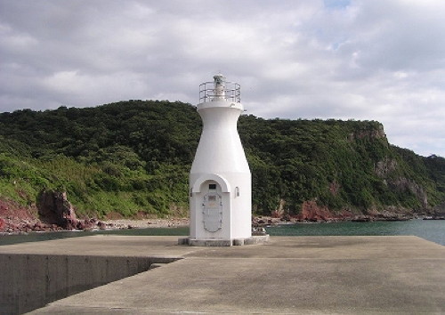
Date unknown. Active; focal plane 17 m (56 ft); green flash every 3 s. 7.5 m (25 ft) round bottle-shaped concrete tower. Entire lighthouse is white. A Coast Guard photo is at right, FOAL has photos, Trabas has a fine closeup photo, Kenichiro Asai has a 2022 view from the sea, and Google has a satellite view and a distant street view. Located at the east end of the detached breakwater of Mie harbor. Accessible only by boat. Site open, tower closed. JCG-6327.4; Admiralty M5202.3; NGA 11835.
Mie Outer Breakwater West End
1988. Active; focal plane 16 m (52 ft); red flash every 3 s. 9.5 m (31 ft) round concrete tower, flared at the top, attached to a small equipment shelter. Entire lighthouse is red. The Coast Guard's page has a photo, FOAL has a photo, Trabas has a photo, and Google has a satellite view. Located at the west end of the detached breakwater of Mie harbor. Accessible only by boat. Site open, tower closed. JCG-6327.3; Admiralty M5202; NGA 11834.
* Mie Kō (Nagasaki Gyoko) Range Front
1992. Active; focal plane 67 m (220 ft); continuous yellow light. 13 m (43 ft) square cylindrical concrete tower with gallery, rising from a 1-story concrete equipment room. Entire lighthouse is white. Our Lighthouses has a page with good photos, FOAL has photos, the Coast Guard's page has a photo showing both range lights in action, Trabas has a photo, and Google has a street view and a satellite view. The light is displayed from a triangular topmark mounted above the gallery. This light guides vessels into a new harbor that has been developed about 12 km (7.5 mi) northwest of Nagasaki; these facilities were needed because the traditional harbor is a narrow fjord of limited capacity. The rear light is on a smaller tower higher on the hill. Located on a bluff above the harbor. Site open, tower closed. ARLHS JPN-812; JCG-6327.2; Admiralty M5202.5; NGA 11833.
* Mie Ura East Breakwater
1965. Active; focal plane 11 m (36 ft); red flash every 4 s. 8.5 m (28 ft) concrete post attached to a 1-story concrete equipment room and mounted on a square concrete pier. Entire lighthouse is red. The Coast Guard's page has a photo, Trabas has a photo, FOAL has photos, and Google has a satellite view and a distant street view. Located on the breakwater of the traditional small boat harbor at Mie. Accessible by walking the pier. Site and tower closed. JCG-6327; Admiralty M5203; NGA 11832.
Nō Se
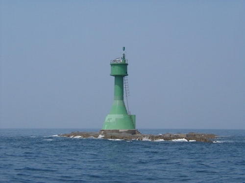
1960. Active; focal plane 19 m (62 ft); one short and one long green flash every 8 s. 15 m (49 ft) tapered round tower, painted green. The Coast Guard's page has a photo (also seen at right),Trabas has a closeup photo, FOAL has distant views, and Google has a satellite view. Located on the southwesternmost islet of a rocky reef extending southwestward just west of the Mie harbor entrance. Accessible only by boat, although there is probably a good view from the mainland. Site open, tower closed. JCG-6326; Admiralty M5201; NGA 11836.

Mie Outer Breakwater East Light
Mie Outer Breakwater East End Light, Nagasaki
Japanese Coast Guard Nagasaki Office photo


No Se Light, Nagasaki
Japanese Coast Guard Nagasaki Office photo

Saikai City Lighthouses

Saikai occupies the northern half of the Nishisonogi Peninsula immediately to the north of Nagasaki. The peninsula encloses Ōmura Bay, a brackish bay 26 km (16 mi) long and 16 km (11 mi) wide connected to the sea by a narrow channel. Rugged in terrain, Saikai has a population of less than 35,000.

Saikai Harbor Lighthouses
Ōhiki Shima (Ō Se)
1965. Active; focal plane 16 m (52 ft); white flash every 4 s. 15 m (49 ft) round tapered concrete tower. Entire lighthouse is white. Trabas has a very distant view and Google has a satellite view. Located on a skerry about 11 km (7 mi) west southwest of Seto Kō. Accessible only by boat. Site status unknown. ARLHS JPN-2243; JCG-6325; Admiralty M5207; NGA 11840.
Kashira Shima
1970. Active; focal plane 19 m (62 ft); white flash every 3 s. 15 m (49 ft) round tapered concrete tower. Entire lighthouse is white. The Coast Guard has a page with a photo, FOAL has photos, Trabas has a photo, Kenichiro Asai has a distant 2022 view, and Google has a satellite view. Located on a skerry about 3 km (1.8 mi) south of Seto harbor. Accessible only by boat. Site status unknown. ARLHS JPN-2197; JCG-6324; Admiralty M5207.6; NGA 11856.
* Seto Fukushima Kō (South Breakwater)
1966. Inactive since 2022. 9.5 m (31 ft) concrete post attached to a square 1-story concrete equipment shelter. Entire lighthouse is red. The Coast Guard has a page with a photo, Trabas has a closeup photo, FOAL has photos (halfway down the page), and Google has a satellite view. Located at the end of the south breakwater of Seto harbor in Saikai. Accessible by walking the pier. Site open, tower closed. JCG-6323; ex-Admiralty M5208; NGA 11852.
Seto Fukushima Kō North Breakwater
Date unknown. Active; focal plane 12 m (39 ft); two green flashes every 6 s. 8.5 m (28 ft) concrete post attached to a square 1-story concrete equipment shelter. Entire lighthouse is white. The Coast Guard has a page with a distant view, Trabas has a closeup photo, FOAL has photos (second row right and 2/3 the way down the page), a 2022 photo is available, and Google has a satellite view. Located at the end of the detached north breakwater of Seto harbor in Saikai. Accessible only by boat. Site open, tower closed. ARLHS JPN-2261; JCG-6322; Admiralty M5208.4; NGA 11848.
Nezumi Se
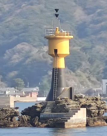
Date unknown. Active; focal plane 15 m (49 ft); six quick white flashes followed by one long white flash every 15 s. 11 m (36 ft) round concrete tower with a large round equipment section. Upper half of the tower painted yellow, lower half black. Kenichiro Asai has the closeup photo at right, Trabas has a photo, FOAL has photos and Google has a satellite view. Located on a rock about 1.2 km (3/4 mi) west of the Saikai waterfront. Accessible only by boat, but there's a good view from ferries between Seto and Matsushima. Site open, tower closed. JCG-6319; Admiralty M5209; NGA 11844.
Matsu Shima Breakwater
Date unknown. Active; focal plane 13 m (43 ft); continuous red light with a more intense flash every 4 s. 8 m (26 ft) round concrete tower, flared at the top, attached to a small equipment shelter. Entire lighthouse is red. Trabas has a photo, FOAL has a photo (third from last row, on the left), and Google has a satellite view and a distant sea view from an arriving ferry. Matsu Shima is a roughly circular island about 3 km (2 mi) in diameter that shelters the harbors of Saikai. Located at the end of an 800 m (1/2 mi) long breakwater extending from the northwestern tip of Matsu Shima. Site status unknown. ARLHS JPN-2223; JCG-6315; Admiralty M5209.5; NGA 11860.

Nezumi Se Light, Saikai, January 2022
Google Maps photo by Kenichiro Asai

Northern Saikai Offshore Lighthouses
Kabuto Shima (Kabutojima) (2?)
Date unknown. Active; focal plane 24 m (79 ft); white flash every 3 s. 8.5 m (28 ft) round white concrete tower. Trabas has a view from the sea, Lighthouse Visits has a small photo, Our Lighthouses has a distant view, FOAL has distant views, Kenichiro Asai has a 2022 view from the ea, and Bing has a satellite view. Located on a reef in the channel between Ōshima and the mainland of the Nishisonogi Peninsula. Accessible only by boat. Site status unknown. ARLHS JPN-803; JCG-6314; Admiralty M5210; NGA 11872.
Mitoko Shima (Mitokojima)
Date unknown. Active; focal plane 48 m (157 ft); white light, 3 s on, 3 s off; also a continuous white spotlight (JCG-6306) illuminates a nearby reef. 11 m (36 ft) round concrete tower. Entire lighthouse is white. FOAL has photos, Trabas has a photo, and Google has a satellite view. Located on an island about 2.5 km (1.5 mi) southeast of Sakito. Accessible only by boat. Site status unknown. ARLHS JPN-363; JCG-6305; Admiralty M5211; NGA 11900.
Ōdate (O-Date) Shima
Date unknown. Active; focal plane 85 m (279 ft); white flash every 5 s. 11 m (36 ft) round white concrete tower with gallery attached to a square 1-story equipment shelter. A distant view is available (#6308, about 1/4 the way down the page), Trabas also has a very distant view, and Google has a satellite view. Located on an isolated high island about 20 km (13 mi) west of Mitoko Shima. Accessible only by boat. Site status unknown. ARLHS JPN-468; JCG-6308; Admiralty M5224.
Yoko Sone
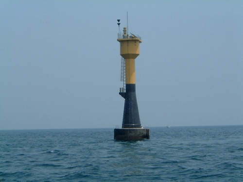
1987. Active; focal plane 23 m (75 ft); six quick white flashes followed by one long white flash every 15 s. 24 m (79 ft) tower. Upper half of the tower painted yellow, lower half black. A Coast Guard photo is at right and another photo is available (#6309.2 about 1/4 the way down the page). Located on an isolated rock 25 km (15 mi) west southwest of Mitoko Shima. Accessible only by boat. Site open, tower closed. JCG-6309.2; Admiralty M5224.5; NGA 11906.

Yoko Sone Light, Saikai
Japanese Coast Guard Nagasaki Office photo

Ōmura Bay Lighthouse
Ta Shima (Tajima)
Date unknown. Active; focal plane 31 m (102 ft); white flash every 3 s. 11 m (36 ft) round concrete tower. Entire lighthouse is white. Lighthouse Visits has a small photo, a small photo of the top of the tower (#6294, about 1/3 the way down the page) is available, Trabas has a similar photo, and Google has a satellite view. Located on an island in the northwestern corner of Ōmura Bay, an almost totally-enclosed bay southeast of Sasebo and east of the Nishisonogi Peninsula. Accessible only by boat. Site status unknown. ARLHS JPN-2271; JCG- 6294; Admiralty M5233; NGA 11868.

Information available on lost lighthouses:

Notable faux lighthouses:

Adjoining pages: North: Sasebo Area | South: Amakusa Islands | East: Kumamoto Area | West: Gotō Islands

Return to the Lighthouse Directory index | Ratings key

Posted August 6, 2007. Checked and revised April 30, 2024. Lighthouses: 49. Site copyright 2024 Russ Rowlett and the University of North Carolina at Chapel Hill.