Lighthouses of Japan: Kushikino Area

The nation of Japan, known in Japanese as Nihon or Nippon (日本), occupies an archipelago off the east coast of Asia. The four main islands are Hokkaidō in the north, Honshū (the largest), Shikoku in the south, and Kyūshū in the southwest. The country includes thousands of other islands of all sizes; among them the Ryūkyū (Nansei) Islands are a long chain extending to the southwest and including the large island of Okinawa, and the Nanpō Islands are another long chain extending south into the Pacific Ocean. Much of Japan is mountainous but the coastal regions are densely populated and urbanized; the country's population is about 126 million.

Located at the southwestern end of the Japanese archipelago, the island of Kyūshū is divided into seven prefectures. This page includes lighthouses of the Kushikino area in western Kagoshima Prefecture, the southernmost prefecture of Kyūshū and of the main islands of Japan. Kagoshima Prefecture also includes the Kagoshima Area, the Ōsumi Islands, and the Amami Islands; the two latter groups form the northern half of the Nansei Shotō (Ryukyu Islands).

In Japanese, the word for a lighthouse is tōdai or toudai (灯台). The words saki and misaki are for capes and headlands, hana ("nose") is a promontory, hantō is a peninsula, shima (also spelled sima or jima) is an island, bae is a reef, iwa or shi is a rocky reef, amase or se is a shoal, wan is a bay, nada is a sound or basin, kaikyō is a strait, kawa is a river, and or minato is a harbor.

Lighthouses in Japan are operated and maintained by the Japanese Coast Guard's Maritime Safety Agency. There is at least one Coast Guard Section Office in each prefecture, often two or more. Lighthouses on this page are maintained by the Coast Guard office at Kushikino (now part of the merged city of Ichikikushikino).

ARLHS numbers are from the ARLHS World List of Lights. JCG numbers are the Japanese Coast Guard's light list numbers. Admiralty numbers are from volume M of the Admiralty List of Lights & Fog Signals. U.S. NGA List numbers are from Publication 112.

General Sources
Lighthouses in Japan - Kagoshima
This site has photos and data for the major lighthouses.
Our Lighthouses of Kagoshima Prefecture
A comprehensive collection of photos of Kagoshima lighthouses.
Lighthouse-Japan.com - Kagoshima
Another comprehensive site, with many photos.
Form of a Lighthouse - Kagoshima
Another site with many photos of Japanese lighthouses, cited below as FOAL.
Lighthouse Visits
This site has photos for many lighthouses in this area.
Lighthouses in Kagoshima Prefecture
Photos by various photographers available from Wikimedia.
Region Ten Lighthouses
Information and photos posted by the Tenth Coast Guard Region office, which is responsible for Kagoshima Prefecture.
Online List of Lights - Japan
Photos by various photographers posted by Alexander Trabas.
Navionics Charts
Navigational chart information for southern Kyūshū.
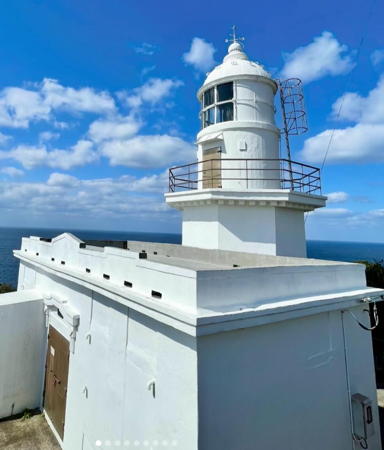

Bōno Misaki Light, Minamisatsuma, March 2024
Instagram photo by satopi
South Coast Lighthouses

Minamisatsuma (South Satsuma) City Lighthouses
Bōno Misaki
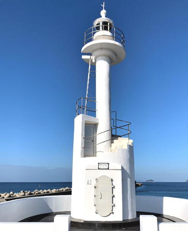
1922. Active; focal plane 84 m (276 ft); three white flashes every 30 s. 12 m (39 ft) octagonal cylindrical concrete tower with lantern and gallery, attached to a 1-story concrete keeper's cottage. Entire lighthouse is white. A 2024 photo is above, Trabas has a drone view, Lighthouse-Japan.com has a page with fine closeup photos, Our Lighthouses has a page with excellent photos, FOAL's page has additional photos, a 2016 closeup is available, and Google has a satellite view and a distant sea view. This lighthouse marks the extreme southwestern tip of the Satsuma Peninsula, which separates Kagoshima Bay on the east from the East China Sea on the west. Located about 7 km (4.5 mi) west of Makurazaki, at the end of a rugged promontory. Accessible by hiking the narrow, twisting service road; it's a long walk, but the payoff is a spectacular view. Site open, tower closed. . ARLHS JPN-047; JCG-6605; Admiralty M4812; NGA 11064.
Uji Islands (Uji Ie Shima)
Date unknown. Active; focal plane 103 m (338 ft); white flash every 3 s. 9.5 m (31 ft) round concrete tower with gallery. Entire lighthouse is white. A visitor in 2014 has a photo and Google has a satellite view. The Uji Islands are a small group located about 80 km (50 mi) southwest of Noma Misaki and a similar distance south of the Gotō Islands. Located on the highest point of Ie Shima, the easternmost of the islands. Accessible only by boat. Site open but difficult to visit, tower closed. ARLHS JPN-2037; JCG-6601; Admiralty M4805; NGA 12984.
#Minega Saki
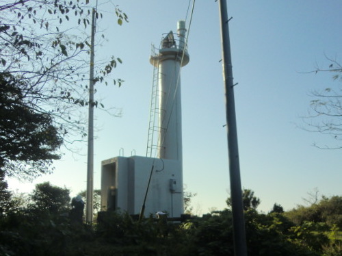
1971. Inactive since 2018 and later demolished. 8.5 m (28 ft) round concrete tower attached to a square 1-story concrete equipment room. Entire lighthouse is white. Lighthouse-Japan.com has a page with photos, FOAL's page has good photos, and Our Lighthouses also has good photos and Google has a very distant 2015 sea view. Bing's satellite view confirms the removal of the lighthouse. The light was deactivated in November 2018. Located on a rugged promontory about 3 km (1.8 mi) north of Bōno Misaki. Accessible by hiking the service road. Site open, tower closed. ARLHS JPN-355; ex-JCG-6602; ex-Admiralty M5080; NGA 11068.
Satsuma (Satuma) Noma Misaki
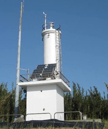
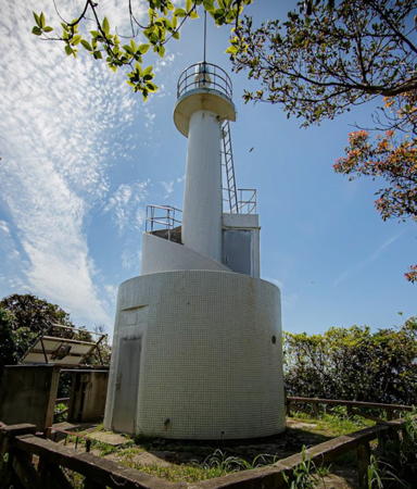
1959. Active; focal plane 149 m (489 ft); white flash every 5 s. 10.5 m (34 ft) concrete post centered on a round 1-story concrete equipment room. Entire lighthouse is white. Chie Ikeda's 2022 photo is at right, Trabas has a photo, Mata Omaeka has a 2021 closeup, Lighthouse-Japan.com has a page with closeup photos, Our Lighthouses has good photos, FOAL's page has additional photos, Chie Ikeda has a 2022 photo, and Google has a satellite view and a distant sea view. This light marks the westernmost extension of the Satsuma Peninsula. Located on the heights of a long, hook-shaped promontory about 20 km (13 mi) northwest of Bōno Misaki. Accessible by hiking the service road. Site open, tower closed. . JCG-6579; Admiralty M5083; NGA 11072.
* Kataura Kō
1932. Active; focal plane 11 m (36 ft); white flash every 3 s. 9 m (30 ft) square white concrete tower. Trabas has a closeup photo, Our Lighthouses has photos, FOAL's page also has photos, and Google has a sea view and a satellite view. The light was formerly located at the end of the west breakwater at Kataura, but that breakwater has been extended more than 800 m (1/2 mi) into the bay. Accessible by walking the pier. Site open, tower closed. ARLHS JPN-2049; JCG-6578; Admiralty M5084; NGA 11080.

Satsuma Noma Misaki Light, Minamisatsuma, April 2022
Google Maps photo by Chie Ikeda
 

West Coast Lighthouses

Ichikikushikino (Kushikino) City Lighthouses
The city of Ichikikushikino was formed in 2005 by merging the seaport of Kushikino with the adjoining town of Ichiki.
* Kushikino (Kusikino) Kō (Naga Saki)
1951. Inactive since 2009. 12 m (39 ft) concrete post centered on a round 1-story concrete equipment room. Entire lighthouse is white. A 2021 photo is at right, a 2023 closeup and a 2020 sunset photo are available, and Google has a street view and a satellite view. Expansion of the port of Kushikino made this light redundant but the tower is to be preserved as a historical monument. Lighthouse-Japan.com has a 2008 photo showing the two lights of this tower in action. Located at the root of the south breakwater of Kushikino; accessible by car or by a short walk from the fishing port. Parking available. Site open, tower closed. . ARLHS JPN-315; ex-JCG-6577; ex-Admiralty M5087; ex-NGA 11124.
* Kushikino Kō Mitsu Se
2014. Active; focal plane 15 m (49 ft); continuous white spotlight. 7 m (23 ft) square white concrete tower; the light is shown through a square window. Trabas has a closeup photo, there's a photo of the light in action, and Google has a satellite view. The spotlight illuminates a reef 700 m (0.44 mi) to the south. The light was formerly mounted on the Naga Saki lighthouse (previous entry). Located at the foot of the south breakwater of Kushikino. Site open, tower closed. JCG-6577.01; Admiralty M5087; NGA 11124.
Kushikino (Kusikino) West (Detached) Breakwater
Date unknown. Active; focal plane 16 m (52 ft); two green flashes every 6 s. 11 m (36 ft) round concrete tower flared at the top. Entire lighthouse is white. Trabas has a photo, FOAL's page for the Kushikino lights has photos (bottom of the page), Lighthouse Visit also has photos, and Google has a satellite view. Located at the south end of the detached north breakwater of Kushikino. Accessible only by boat. Site and tower closed. ARLHS JPN-2057; JCG-6573.5; Admiralty M5087.5; NGA 11126.
Satsuma (Satuma) Okino Shima
1970. Active; focal plane 87 m (285 ft); white flash every 4 s. 9.5 m (28 ft) round concrete tower with gallery, rising from a square concrete base. Entire lighthouse is white. The Coast Guard has a closeup photo, Our Lighthouses has a distant view, FOAL's page has several views, Trabas has a distant view, and Google has a satellite view. Located atop an isolated high island about 8 km (5 mi) west of Kushikino. Accessible only by boat. Site and tower closed. ARLHS JPN-546; JCG-6573; Admiralty M5091; NGA 11128.

Kushikino Kō Light, Ichikikushikino, July 2021
Instagram photo by todai_oshiro

Satsumasendai City: Sendai Harbor Lighthouses

Known locally as Sendai, the city is officially called Satsumasendai to distinguish it from the better-known city of Sendai in northeastern Honshū.

Satsumasendai (Sendai Kō) South Breakwater
1996. Active; focal plane 18 m (59 ft); two red flashes every 6 s. 12 m (39 ft) round concrete tower, flared at the top. Entire lighthouse is red. Trabas has a good photo, Wanz Kogata has a 2022 photo, FOAL has a photo (halfway down the page), and Google has a satellite view and a very distant street view. Located at the end of a 2.5 km (1.5 mi) long breakwater on the north side of the mouth of the Sendai River. Accessible in good weather by walking the pier, but it's an hour's walk roundtrip. Site open, tower closed. ARLHS JPN-2070; JCG-6570.21; Admiralty M5094; NGA 11136.
Satsumasendai (Sendai Kō) Outer Breakwater
1996 (?). Active; focal plane 17 m (56 ft); two green flashes every 6 s. 11 m (36 ft) round concrete tower, strongly flared at the top. Entire lighthouse is white. Trabas has a closeup photo, Wanz Kogata has a 2022 photo, FOAL has another photo (second photo on the page), and Google has a satellite view. Located at the west end of the detached outer breakwater of Satsumasendai. Accessible only by boat. Site open, tower closed. ARLHS JPN-2071; JCG-6570.2; Admiralty M5094.3; NGA 11138.
Satsumasendai (Sendai Kō) West Breakwater South Head
Date unknown. Active; focal plane 14 m (43 ft); green flash every 3 s. 10.5 m (34 ft) concrete post attached to a 1-story concrete equipment room. Entire lighthouse is white. Trabas has a closeup photo, FOAL has another photo (second photo on the page), and Google has a satellite view. Located at the west end of the older detached breakwater of Satsumasendai. Accessible only by boat. Site open, tower closed. JCG-6570; Admiralty M5094.28; NGA 11140.

Satsumasendai City: Koshikijima Islands Lighthouses
The Koshikijima Islands are located in the East China Sea roughly 35 km (22 mi) west of the coast of Kyūshū. The islands extend southwestward for about 40 km (25 mi). The largest islands are Kami-Koshikijima (Upper Koshikijima), at the northern end of the group, and Shimo-Koshikijima (Lower Koshikjima) in the south. The islands have a population of about 5500 and are administered as part of Satsumasendai City.

Naka Se
1955. Active; focal plane 19 m (62 ft); two white flashes every 5 s. 17.5 m (58 ft) round cylindrical concrete tower with double galleries and a conical base, centered on a round concrete pier. Lighthouse painted black with one red horizontal band. The lighthouse is not shown in Google's satellite view. Located on an isolated rock about halfway between the mainland and Sato Saki. Accessible only by boat. Site and tower closed. JCG-6572; Admiralty M5093; NGA 11148.
Nawase Hana
1975. Active; focal plane 175 m (574 ft); white flash every 5 s. 10 m (33 ft) concrete post attached to a square 1-story concrete equipment room. Entire lighthouse is white. The Coast Guard's closeup photo is at right and Google has a satellite view. Located atop at steep promontory at the northernmost point of the islands. Site status unknown. ARLHS JPN-405; JCG-6580; Admiralty M4997; NGA 11160.

Nawase Hana Light, Kami-Koshikijima
Japanese Coast Guard Kushikino Office photo
Ite Saki
1972. Active; focal plane 83 m (272 ft); white flash every 3 s. 11.5 m (38 ft) round cylindrical concrete tower with gallery, centered on a 1-story concrete equipment room. Entire lighthouse is white. The Coast Guard has the photo at right, a view from the sea is available, and Google has a satellite view. Located atop at steep promontory at the northeasternmost point of Kami-Koshikijima. Site status unknown. ARLHS JPN-786; JCG-6581; Admiralty M5092; NGA 11156.
Sato Saki (Satomura)
1977. Active; focal plane 54 m (177 ft); white light, 3 s on, 2 s off. 10 m (33 ft) round concrete tower attached to a 1-story concrete equipment room. A view from the sea is available and and Google has a satellite view. Located on a promontory on Kami-Koshikijima about 3 km (2 mi) south of Ite Saki. Site status unknown. ARLHS JPN-541; JCG-6582; Admiralty M4996.4; NGA 11152.
#Nakakoshiki Kō (1)
Date unknown. Replaced in 2016. This was a 7 m (23 ft) concrete post attached to a 1-story concrete equipment room. Entire lighthouse was white. Google has a 2013 street view. The lighthouse was replaced by a light on a post (focal plane 10 m (33 ft); green flash every 4 s) in May 2016. Google's satellite view and 2024 street view confirm the removal of the lighthouse. Located at the end of the main breakwater at Nakakoshiki, the principal harbor of Kami-Koshikijima. Probably accessible by walking the pier. Site open, tower closed. Active light: JCG-6583; Admiralty M4996; NGA 11104.
Nakakoshiki Entry (Tsutsuminishi)
Date unknown. Active; focal plane 12 m (39 ft); red flash every 4 s. 9 m (30 ft) round concrete tower attached to a square 1-story concrete equipment room. Entire lighthouse is red. A distant view is available, a speedboat passes the light in a 2024 video, and Google has a street view and a satellite view. Located on a breakwater (technically known as a training wall) guiding ships under the bridge connecting Kami-Koshikijima to Nakakashika Shima to the south. Site status unknown. JCG-6584; Admiralty M4995; NGA 11108.
* Tsubura Saki (Tubura Saki)
1965. Active; focal plane 91 m (299 ft); four white flashes every 15 s. 8.5 m (28 ft) round concrete tower with a flared top, attached to a square 1-story concrete equipment room. Entire lighthouse is white. Hysd Jagua has a 2022 closeup photo, Akifumi Nishitsuji has a 2022 street view, and and Google has a satellite view. Located at the northernmost point of Shimo-Koshikijima. Accessible by road; the road reaches a dead end and the lighthouse is just beyond the trees. Site status unknown. ARLHS JPN-686; JCG-6586; Admiralty M4994.6; NGA 11088.

Ite Saki Light, Shimo-Koshikijima
Japanese Coast Guard Kushikino Office photo
* #Torinosu Yama
1971. Inactive since 2020. and removed by 2022. 9.5 m (31 ft) round concrete tower attached to a square 1-story concrete equipment room. Entire lighthouse is white. A 2021 photo and a 2018 photo are available. An observation deck at the location of the former lighthouse provides a spectacular view. The light was deactivated in September 2020. A 2022 street view and Google's indistinct satellite view confirm the removal of the lighthouse. Located on a promontory about 2 km (1.2 mi) southeast of the Tsubura Saki lighthouse. Site open, tower closed. . ARLHS JPN-675; ex-JCG-6587; ex-Admiralty M4994.7; NGA 11084.
* Teuchi Kō
Date unknown. Active; focal plane 17 m (56 ft); two green flashes every 6 s. 11 m (36 ft) round cylindrical concrete tower with a flared top, attached to a small equipment shelter. Entire lighthouse is white. Google has a 2013 street view and a satellite view. Located on a short breakwater on the south side of the entrance to Teuchi harbor, at the southeastern tip of Shimo-Koshikijima. Accessible by walking the pier. Site open, tower closed. ARLHS JPN-2080; JCG-6590; Admiralty M4994; NGA 11100.
* Tsurikake (Turikake) Saki (2)
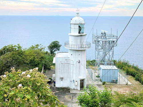
1951 (station established 1896). Active; focal plane 146 m (479 ft); white flash every 15 s. 17 m (56 ft) round concrete tower with lantern and gallery, attached to a small concrete equipment shelter. 3rd order clamshell Fresnel lens in use. A 2024 photo is at right, Kazuhiro Nishihas a 2021 photo, the Coast Guard has a page for the lighthouse, Hideo Komai has a lovely 2017 photo, Hiroyuki Watanabe has a 2022 photo, and Google has a satellite view. The original stone lighthouse was destroyed by a U.S. air raid during World War II. Located at the southern tip of Shimo-Koshikijima, marking the southern end of the island group. Accessible by road and a walk of about 200 m (1/8 mi); parking provided. Site open, tower closed. . ARLHS JPN-695; JCG-6591; Admiralty M4992; NGA 11096.

Tsurikake Saki Light, Shimo-Koshikijima, February 2024
Instagram photo by maonarumi.tokyojapan_view

Akune City Lighthouses
Akune Kō
1962. Active; focal plane 43 m (141 ft); two white flashes every 10 s; a continuous white light (JCG-6566) illuminates an obstruction some 300 m (325 yd) away. 10 m (33 ft) round concrete tower attached to a 1-story concrete equipment room. Entire lighthouse is white. Lighthouse-Japan.com has a page with photos, Our Lighthouses has good photos, FOAL's page has photos, Trabas has a drone view, and Google has a satellite view. Located on a headland near the south entrance to Akune harbor. The light is accessible by a short walk from the harbor, but local guidance will be needed to find the pathway. Site open, tower closed. ARLHS JPN-015; JCG-6565; Admiralty M5095; NGA 11164.
* Akune Kō Old Port West Breakwater
1937. Active; focal plane 12 m (39 ft); red light, 3 s on, 3 s off. 8.5 m (28 ft) concrete post attached to a 1-story concrete equipment room. Entire lighthouse is red. Trabas has a closeup photo, FOAL has another photo (middle of the page, right), Lighthouse Visit has a photo (last lighthouse on the page), and Google has a satellite view and a distant street view. Located on the west breakwater of Akune's original harbor. Accessible by walking the pier. Site open, tower closed. ARLHS JPN-2033; JCG-6564; Admiralty M5096; NGA 11168.
Akune Kō East Port Breakwater
1990. Active; focal plane 13 m (43 ft); red flash every 4 s. 9.5 m (31 ft) round concrete tower, flared at the top. Entire lighthouse is red. Trabas has a photo, Minoru Uenohara has a photo, FOAL has another photo (bottom of the page) and Google has a satellite view. NGA calls this the east breakwater, but it is really the south breakwater of the new port, known as the east port. Located at the end of a 900 m (0.56 mi) long breakwater on the south side of Akune harbor. Accessible in good weather by walking the pier, but it's a long walk. Site open, tower closed. ARLHS JPN-2032; JCG-6563.5; Admiralty M5099; ex-NGA 11169.
Kohira Se (Kohirase Kō, Kobira Se)
Date unknown. Active; focal plane 20 m (66 ft); three white flashes every 13 s; a continuous white light (JCG-6560) illuminates the nearby Hira Se reef. 9 m (30 ft) round concrete tower attached to a 2-story concrete equipment room. Entire lighthouse is white. A Coast Guard photo is at right, Our Lighthouses has good photos, FOAL's page for the lighthouse has excellent photos, Trabas has a closeup photo, S. Katsuragi has a closeup, and Google has a satellite view. This light guides ships in the narrow channel between the mainland and Naga Shima. Located atop a steep bluff about 2.5 km (1.5 mi) west of Wakimoto. Site open, tower closed. ARLHS JPN-2051; JCG-6559; Admiralty M5100; NGA 11172.

Kohira Se Light, Shimo-Koshikijima
Japanese Coast Guard Kushikino Office photo

Nagashima Town Lighthouses
Most of the town of Nagashima occupies the island of Naga Shima. The island is about 16 km (10 mi) long and 11 km (7 mi) wide; it is separated from the mainland by a narrow strait crossed by a bridge.
Satsuma (Satuma) No Se
Date unknown. Active; focal plane 13 m (43 ft); one short and one long green flash every 8 s. 12 m (39 ft) round cylindrical concrete tower with double gallery. Entire lighthouse is green. Trabas has a photo, FOAL has additional photos, S. Katsuragi has a 2020 photo, and Google has a satellite view. Located on a reef on the west side of the entrance to a narrow strait separating Nagashima Island from the mainland. Accessible only by boat. Site open, tower closed. JCG-6558; Admiralty M5100.2; NGA 11180.
* Yatsushiro Nagasaki Hana (3)
1977 (station established 1897). Active; focal plane 27 m (89 ft); white flash every 10 s. 15 m (49 ft) octagonal cylindrical concrete tower with lantern and gallery, centered on a 1-story octagonal concrete keeper's house. Entire lighthouse is white. A 2020 photo is at right, Lighthouse-Japan.com has a page with good photos, Our Lighthouses also has good photos, FOAL's page for the lighthouse has photos, the Coast Guard has a page for the lighthouse, Trabas has a photo, and Google has a street view and a satellite view. Located on a promontory on Naga Shima marking the east side of the entrance to Yatsushiro Bay. Accessible by road and parking is provided. Site open, tower closed. . ARLHS JPN-2066; JCG-6562; Admiralty M5102; NGA 11184.
Mate Shima
1968. Active; focal plane 24 m (79 ft); white flash every 4 s. 9 m (30 ft) round cylindrical concrete tower. Entire lighthouse is white. S. Katsuragi has a 2021 photo, Trabas has a distant view, and Google has a satellite view. Located at the northern tip of Mate Shima, an island in the southwestern corner of Yatsushiro Bay. Site status unknown. ARLHS JPN-2061; JCG-6500; Admiralty M5129; NGA 11392.

Izumi City Lighthouse
#Komenotsu Kō West Breakwater
Date unknown. Removed in 2010. This was an 8.5 m (28 ft) concrete post attached to a square equipment shelter. The entire lighthouse was red. Google's satellite view confirms the removal of the light. Construction of new outer breakwaters made the light obsolete. The new breakwaters are marked by post lights. Formerly located on the west breakwater of Komenotsu harbor, at the south end of Yatsushiro Bay. ex-JCG-6549; ex-Admiralty M5133.

Yatsushiro Nagasaki Hana Light, Nagashima, October 2020
Google Maps photo by B A

Information available on lost lighthouses:

Notable faux lighthouses:

Adjoining pages: North: Kumamoto Area | East: Kagoshima Area | South: Ōsumi Islands

Return to the Lighthouse Directory index | Ratings key

Posted July 23, 2007. Checked and revised April 9, 2024. Lighthouses: 30. Site copyright 2024 Russ Rowlett and the University of North Carolina at Chapel Hill.