Lighthouses of Japan: Kitakyūshū Area

The nation of Japan, known in Japanese as Nihon or Nippon (日本), occupies an archipelago off the east coast of Asia. The four main islands are Hokkaidō in the north, Honshū (the largest), Shikoku in the south, and Kyūshū in the southwest. The country includes thousands of other islands of all sizes; among them the Ryūkyū (Nansei) Islands are a long chain extending to the southwest and including the large island of Okinawa, and the Nanpō Islands are another long chain extending south into the Pacific Ocean. Much of Japan is mountainous but the coastal regions are densely populated and urbanized; the country's population is about 126 million.

Japan is divided into 47 prefectures. Located at the southwestern end of the Japanese archipelago, Kyūshū is divided into seven prefectures. This page includes lighthouses of Fukuoka Prefecture on the northern coast of the island. Western Fukuoka faces northwest on the Tsushima Strait and the Sea of Japan while Eastern Fukuoka faces northeast on the Seto Inland Sea, which separates Kyūshū from Honshū and Shikoku. In between the narrow Kanmon Strait connects the Inland Sea and Sea of Japan. This page includes the lighthouses of the Kitakyūshū area facing the Kanmon Strait and Seto Inland Sea; the Fukuoka Area page includes lighthouses in the western portion of the prefecture.

In Japanese the word for a lighthouse is tōdai or toudai (灯台). The words saki and misaki are for capes and headlands, hana ("nose") is a promontory, hantō is a peninsula, shima (also spelled sima or jima) is an island, bae is a reef, iwa or shi is a rocky reef, amase or se is a shoal, wan is a bay, nada is a sound or basin, kaikyō is a strait, kawa is a river, and or minato is a harbor.

Lighthouses in Japan are operated and maintained by the Japanese Coast Guard's Maritime Safety Agency. There is at least one Coast Guard Section Office in each prefecture, often two or more. Fukuoka Prefecture has three offices, at Fukuoka, Wakamatsu, and Moji.

Fukuoka Prefecture also has a short southern coastline on Ariake Bay. Lighthouses of the Ariake coast are on the Kumamoto Area page.

A note on the Sea of Japan/East Sea controversy: The Directory takes no side in any international dispute; it makes use of the terminology, names, and spellings as they currently exist in each area covered. The sea between Japan and Korea is called the Sea of Japan on the pages for Japan and the East Sea on the pages for Korea.

ARLHS numbers are from the ARLHS World List of Lights. JCG numbers are the Japanese Coast Guard's light list numbers. Admiralty numbers are from volume M of the Admiralty List of Lights & Fog Signals. U.S. NGA List numbers are from Publication 112.

General Sources
Lighthouses in Japan - Fukuoka
A comprehensive site, although almost entirely in Japanese.
Form of a Lighthouse - Fukuoka
Another site with many photos of Japanese lighthouses, cited below as FOAL.
Lighthouse Visits
This site has photos for many lighthouses in this area.
Lighthouse-Japan.com - Fukuoka
This site has good photos and background information for many of the major lighthouses.
Our Lighthouses of Fukuoka Prefecture
A comprehensive collection of photos of lighthouses in Fukuoka.
Coast of Japan - Cape/Lighthouse Index
This site has numerous photos of Fukuoka lighthouses. Entirely in Japanese, but lighthouses can be located by their JCG numbers.
Lighthouses in Fukuoka Prefecture
Photos by various photographers available from Wikimedia.
Online List of Lights - Japan
Photos by various photographers posted by Alexander Trabas. Several Kanmon Strait photos are by Jim Smith.
Navionics Charts
Navigation chart for Kitakyūshū.


Shira Su Light, Wakamatsu-ku, Kitakyūshū, December 2018
Google Maps drone view by Akahori
Kitakyūshū City (Kanmon Strait) Lighthouses

The Kanmon Strait is the narrow passage separating the southwestern tip of Honshū from the northern tip of Kyūshū. Since 1958 the two great islands have been joined by the Kanmon Roadway Tunnel and in 1973 the Kanmon Bridge was opened; there are also two railway tunnels under the strait. The twisting strait has strong tidal currents and is not easy to navigate. Lighthouses on the north (Honshū) side of the strait are described on the Western Yamaguchi page.

Wakamatsu Ward Lighthouses
The former city of Wakamatsu, now a ward of the metropolitan city of Kitakyūshū, faces north on the western approaches to the strait from the Sea of Japan. The Wakamatsu Coast Guard Office maintains the lighthouses in this section.
* Myōken Saki
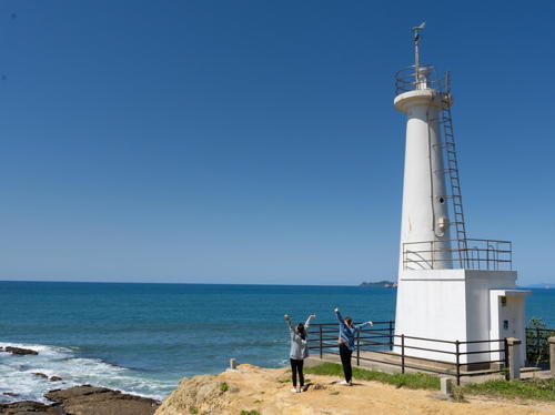
1966. Active; focal plane 26 m (85 ft); white light, 3 s on, 2 s off, 3 s on, 4 s off. 10 m (33 ft) concrete post attached to a square 1-story concrete equipment room. Entire lighthouse is white. A 2024 photo is at right, Lighthouse-Japan.com has a good page for the lighthouse, Our Lighthouses has a page with closeup photos, FOAL's page also has good photos, Brian Kennedy has a fine closeup, Trabas has a photo, a 2021 photo is available, the Coast Guard has photos, Shigeru Hayashida has a street view, and Google has a satellite view. This is a highly accessible and well known lighthouse. Located on a rocky promontory northwest of Nakama, about 13 km (8 mi) west of the Kanmon Strait entrance. Parking available; it's a short walk to the lighthouse. Site open, tower closed. . ARLHS JPN-2015; JCG-5803; Admiralty M5292; NGA 12436.
Shinkōnishi (Hibiki Shinko) West Breakwater
Date unknown. Active; focal plane 13 m (43 ft); two red flashes every 6 s. 9.5 m (31 ft) concrete post attached to a square 1-story concrete equipment room. Entire lighthouse is red. Trabas has a photo, Lighthouse Visits has photos (second lighthouse on the page), and Google has a satellite view. Located at the end of the west breakwater of the Shinkōnishi harbor in the Wakamatsu ward of Kitakyūshū. Accessible only by boat. Site open, tower closed. JCG-5551; Admiralty M5295.5; NGA 12439.5.
Shinkōnishi (Hibiki Shinko) East Breakwater
Date unknown. Active; focal plane 13 m (43 ft); two green flashes every 6 s. 9.5 m (31 ft) concrete post attached to a square 1-story concrete equipment room. Entire lighthouse is white. Trabas has a photo, Lighthouse Visits has photos (first lighthouse on the page), and Google has a satellite view. Located at the end of the east breakwater of the Shinkōnishi harbor in the Wakamatsu ward of Kitakyūshū. Accessible only by boat. Site open, tower closed. ARLHS JPN-2031; JCG-5550; Admiralty M5295; NGA 12439.

Myoken Saki Light, Wakamatsu-ku, Kitakyūshū, June 2024
Instagram photo by kamenoihotel_genkainada
Shira Su (Sira Su, Sirasu, Hakushū) (2)
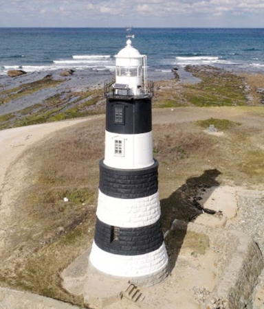
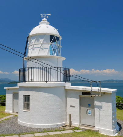
1900 (station established 1873). Active; focal plane 16 m (52 ft); white flash every 4 s. 17 m (56 ft) round 2-stage stone tower with lantern and gallery; the lower half of the tower is stone and the upper half is cast iron. Lighthouse painted with black and white horizontal bands. A photo is at the top of this page, the Coast Guard has an aerial photo, a 2017 drone view is available, Trabas has a view from the sea, Our Lighthouses has a page with distant views, another photo is available, and Google has a satellite view. This is one of Kyūshū's oldest light stations and one of Japan's "Famous Fifty" lighthouses. Because of numerous wrecks on the reef the local headman Iwamatsu Sukezaemon ordered construction of a lighthouse to begin in 1862, before the Meiji restoration. Only the foundation had been completed by 1871, when the new government took over the project. The 1873 lighthouse, a 14.5 m (48 ft) square wood tower incorporating keeper's quarters, was built by the British engineer Richard Henry Brunton to mark the western entrance to the strait. The two-stage tower replaced it in 1900 and continued its black-and-white daymark. Located on an islet about 5 km (3 mi) northwest of the mainland. Accessible only by boat. Site open, tower closed. . ARLHS JPN-795; JCG-5544; Admiralty M5328; NGA 9960.
Ōmozi Iwa
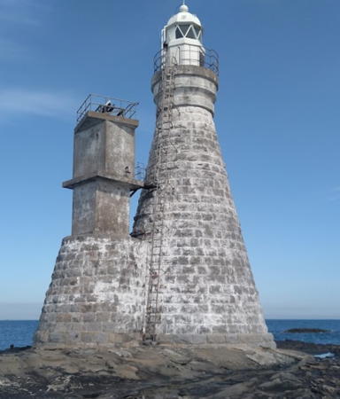
1895. Active; focal plane 15 m (49 ft); white flash every 3 s. 15 m (49 ft) round strongly conical stone tower with lantern and gallery, painted white. Yuichi Muraoka's 2024 photo is at right, another photo is available, the Coast Guard has a photo, Trabas has Smith's view from the sea, and Google has a satellite view. The western deepwater entrance to the Kanmon Strait is from the north rather than the west. This lighthouse is built on an islet on the southwest side of this northern entrance, about 5 km (3 mi) northeast of Shira Su. Accessible only by boat. Site open, tower closed. . ARLHS JPN-793; JCG-5542; Admiralty M5326; NGA 9952.
Ainoshima Kō
Date unknown. Active; focal plane 10 m (33 ft); two green flashes every 6 s. 8.5 m (28 ft) concrete post attached to a square 1-story concrete equipment room. Entire lighthouse is white. Trabas has a distant view, another photo is available, and Google has a satellite view. Located on the main breakwater of Ainoshima, an island in the entrance to the Kanmon Strait. Probably accessible by walking the pier. Site open, tower closed. JCG-5543; Admiralty M5327.5; NGA 9956.

Ōmozi Iwa Light, Wakamatsu-ku, Kitakyūshū, May 2024
Google Maps photo by Yuichi Muraoka
* Dōkai Wan (Entrance Breakwater)
1974. Active; focal plane 12 m (39 ft); red flash every 6 s. 9.5 m (31 ft) concrete post attached to a square 1-story concrete equipment room. Entire lighthouse is red. Trabas has a good photo and Google has a satellite view. Dōkai Wan (Dokai Bay) is an estuary joining the Kanmon Strait at its western end. Located at the end of the long breakwater on the west side of the Dokai Bay entrance. Accessible in good weather by walking the pier. Site open, tower closed. JCG-5507; Admiralty M5297; NGA 9912.

Tobata Ward Lighthouses
The remaining lighthouses on this page guide vessels in the Kanmon Strait; they are maintained by the Moji Coast Guard Office.

Tobata Koro Passage Range Front
Date unknown. Active; focal plane 25 m (82 ft); continuous green light. 24 m (79 ft) square pyramidal skeletal tower with lantern and gallery, painted white. No closeup photo available but Google has a satellite view. The range guides vessels into an industrial basin on the south side of the strait. Located in an industrial area of Kitakyūshū. Site and closed. ARLHS JPN-2026; JCG-5483; Admiralty M5300; NGA 9888.
Tobata Koro Passage Range Rear
Date unknown. Active; focal plane 31 m (102 ft); continuous green light. 30 m (98 ft) square pyramidal skeletal tower with lantern, gallery, and central cylinder, painted with red and white horizontal bands. No closeup photo available but Google has a satellite view. Located in an industrial area of Kitakyūshū. Site and tower closed. ARLHS JPN-2027; JCG-5484; Admiralty M5300.1; NGA 9892.

Kokurakita Ward Lighthouses
* Kokura Breakwater
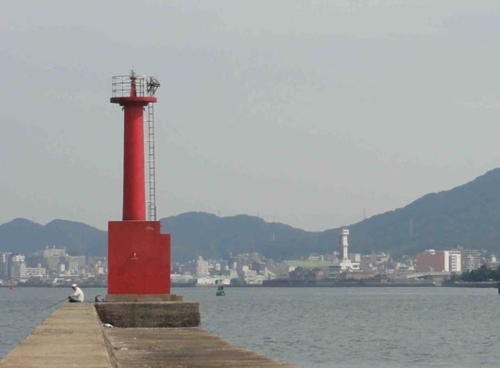
1974. Active; focal plane 11 m (36 ft); red light, 2 s on, 2 s off. 9.5 m (31 ft) concrete post attached to a square 1-story concrete equipment room. Entire lighthouse is red. Trabas has a closeup photo, FOAL's page has photos (on the right in second and third rows), Lighthouse Visits has a page for the lighthouse, Minoru Yoshida has a closeup, and Google has a satellite view and a very distant street view. Located at the end of a long pier in the Kokura neighborhood. Although listed as a "detached breakwater," the pier is connected to land by a short footbridge and is popular with pedestrians. Accessible by walking the pier. Site open, tower closed. ARLHS JPN-2010; JCG-5466; Admiralty M5343.7; NGA 9868.
* Sunatsu (Sunatu) Breakwater
1963. Active; focal plane 12 m (93 ft); red flash every 5 s. 11 m (36 ft) concrete post rising from a square 1-story concrete equipment room. Entire lighthouse is red. Minoru Yoshida's photo is at right, Trabas has a closeup photo, FOAL's page for the Sunatsu lights has a photo, and Google has a good satellite view and a distant street view. Located at the end of the breakwater in the Kokura neighborhood, near the southernmost point of the strait. Accessible by walking the pier. Site open, tower closed. Admiralty JCG-5451; M5345; NGA 9844.
* Sunatsu (Sunatu) Fairway Range Rear
1961. Active; focal plane 14 m (46 ft); continuous green light. 13 m (43 ft) round concrete tower with gallery; the light is shown as a panel of vertical neon tubes within a large arrow-shaped daymark. Entire lighthouse is white. Trabas has a good photo, FOAL's page for the Sunatsu lights has a photo (lower right on the page), and Google has a street view and a satellite view. The front light is on a similar but much smaller tower. This range guides westbound vessels as they make the turn around the southernmost point of the strait. Located on the waterfront at the south end of the Kokura basin. Site open, tower closed. JCG-5453; Admiralty M5344.1; NGA 9852.

Sunatsu Breakwater Light, Kitakyūshū, 2018
Google Maps photo by Minoru Yoshida
 
* Oseto No. 1 Range Front
1966. Active; focal plane 40 m (131 ft); continuous yellow light. 18 m (59 ft) round cylindrical metal tower with gallery; the light is shown as a panel of horizontal neon tubes within a triangular daymark. Entire lighthouse is white. A photo is available, FOAL's page for the range has good photos, Trabas has a photo, and Google has a satellite view. The Oseto ranges guide eastbound vessels in the strait. Located beside highway 3 about 300 m (1000 ft) south of the strait. Site open, tower closed. JCG-5443; Admiralty M5340; NGA 9836.
* Oseto No. 1 Range Rear
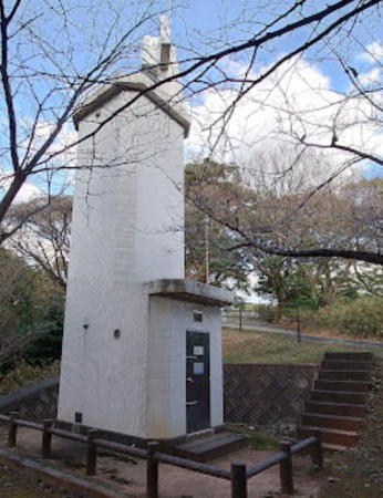
1966 (rebuilt in 2013). Active; focal plane 78 m (256 ft); continuous yellow light. 12 m (39 ft) square cylindrical concrete tower rising from a square base; the light is shown as a panel of horizontal neon tubes within a triangular daymark. Entire lighthouse is white. A 2023 photo is at right, another photo is available, FOAL's page for the range has good photos, Trabas has a photo, and Google has a satellite view and a street view through trees. Located on a hill in Tamukeyama Park, 260 m (850 ft) southeast of the front light. Site open, tower closed. JCG-5444; Admiralty M5340.1; NGA 9840.

Moji Ward Lighthouses
The former city of Moji, now a ward of the metropolitan city of Kitakyūshū, occupies a peninsula separating the eastern half of Kanmon Strait from the open waters of the Seto Inland Sea.

*
Oseto No. 2 Range Front
1966. Active; focal plane 20 m (66 ft); continuous yellow light. 18 m (59 ft) square cylindrical skeletal tower with gallery and a triangular daymark. Entire lighthouse painted white. A photo is available, FOAL's page for the range has photos, Trabas has a good photo and Google has a street view and a satellite view. Located at the edge of the strait adjacent to the Ogura Marina in the Matsubara district of Kitakyūshū. Site open, tower closed. JCG-5439; Admiralty M5340.3; NGA 9820.
* Oseto No. 2 Range Rear
1966. Active; focal plane 30 m (98 ft); continuous yellow light. 28 m (92 ft) square cylindrical skeletal tower with gallery and a triangular daymark. Entire lighthouse painted white. Trabas has a closeup photo, another photo is available, FOAL's page for the range has photos, and Google has a street view and a satellite view. Located near the entrance to the Ogura Marina in the Matsubara district of Kitakyūshū. Site open, tower closed. JCG-5440; Admiralty M5340.31; NGA 9824.

Oseto No. 1 Range Rear Light, Kitakyūshū, January 2023
Google Maps photo by Quappi S.
Oseto No. 3 Range Front
1966. Active; focal plane 26 m (85 ft); continuous yellow light. 19 m (62 ft) round cylindrical concrete tower with gallery; the light is shown as a panel of horizontal neon tubes within a triangular daymark. Entire lighthouse is white. A photo and another photo are available, Trabas has a photo, FOAL also has a photo, and Google has a street view and a satellite view. This range guides eastbound vessels in the strait. Located above a rapid transit rail line in the Komorie district of Kitakyūshū. Site fenced, but the light can be seen from nearby; tower closed. JCG-5433; Admiralty M5340.6; NGA 9804.
Oseto No. 3 Range Rear
1966. Active; focal plane 42 m (138 ft); continuous yellow light. 13 m (43 ft) round concrete tower with double gallery; the light is shown as a panel of horizontal neon tubes within a triangular daymark. Entire lighthouse is white. Trabas has a closeup photo, another photo is available, Google has a satellite view, and the top of the tower is seen in a Google street view. Located 340 m (370 yd) northeast of the front light. Site fenced, but the light can be seen from nearby; tower closed. JCG-5434; Admiralty M5340.61; NGA 9808.
* Moji (Mozi) Kō Breakwater No. 1
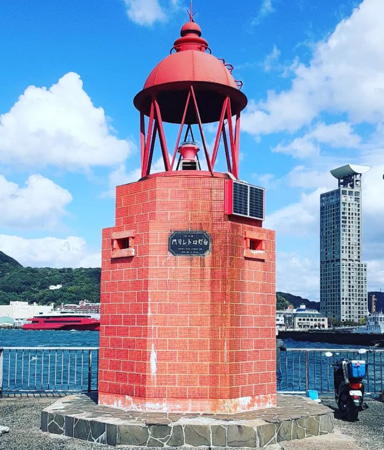
1997. Active; focal plane 7 m (23 ft); red light, 3 s on, 3 s off. 7 m (23 ft) octagonal cylindrical concrete block tower with an open lantern. The concrete blocks are colored red and the lantern is painted red. A 2022 photo is at right, Our Lighthouses has a page with a closeup photo, Trabas has Smith's photo, FOAL's page has good photos, a 2021 photo is available, and Google has a street view and a satellite view. Moji Kō is a harbor with several basins located immediately to the south of the Kanmonkyō Bridge. Located at the end of the breakwater of the southernmost basin. Accessible by walking the pier. Site open, tower closed. . JCG-5426.3; Admiralty M5355.2; NGA 9792.
Moji (Mozi) Kō Breakwater No. 2
Date unknown. Active; focal plane 10 m (33 ft); green flash every 3 s. 9 m (30 ft) concrete post attached to a square 1-story concrete equipment room. Entire lighthouse is white. Trabas has Smith's photo, FOAL's page for the light has photos, Lighthouse Visit also has a page for the light, and Google has a street view and a satellite view. Located at the south end of a detached breakwater of the northern Moji harbor, about 1200 m (3/4 mi) north of the Breakwater No. 1 light and just south of the Kanmonkyō Bridge. Accessible only by boat. Site status unknown. JCG-5426; Admiralty M5354; NGA 9790.

Moji Breakwater No. 1 Light, Moji-ku, Kitakyūshū, October 2022
Instagram photo by toudaisuki
* Moji Saki
1924. Active; focal plane 10 m (33 ft); white light, 3 s on, 3 s off. 7 m (23 ft) round concrete tower adjoining a square 1-story concrete equipment shelter. Trabas has Smith's photo, Lighthouse-Japan.com has a page with photos, another photo is available, FOAL's page for the light has photos, a view from the strait shows the Kanmonkyō Bridge above the lighthouse, and Google has a satellite view. Located at the tip of a promontory just north of the Kanmonkyō Bridge, marking the narrowest point of the strait. Site open, tower closed. . ARLHS JPN-370; JCG-5420; Admiralty M5355; NGA 9774.
* He Saki
1872 (Richard Henry Brunton). Active; focal plane 39 m (128 ft); continuous white light with a more intense flash every 15 s. 10 m (33 ft) round cylindrical granite tower with lantern and gallery, attached to a 1-story semicircular granite keeper's cottage. Entire lighthouse painted white. An additional 1-story keeper's house adjoins the lighthouse. A 2024 photo is at right, Lighthouse-Japan.com has a page with several fine photos, Our Lighthouses has a page with several closeup photos, FOAL's page has good photos, Trabas has Smith's photo, Akihiro Ohno has a 2021 photo, another photo and a closeup are available, Ama Ya has a street view, and Google has a satellite view. This light, one of Japan's "Famous Fifty" lighthouses, marks the eastern entrance to the Kanmon Strait from the Inland Sea. First lit on 22 January 1872, it is Kyūshū's oldest lighthouse and one of the oldest in Japan. It was upgraded with a rotating Fresnel lens in 1895. Surrounded by a forested park, the light station is a place of serene beauty--although just to the west the park is bordered by a huge stone quarry. Located on a promontory overlooking the Inland Sea about 16 km (10 mi) northeast of Kitakyūshū. Site open, although parking is limited and it's a steep climb to the lighthouse, tower closed. . ARLHS JPN-098; JCG-5409; Admiralty M5312; NGA 9766.
* Hishakuda (Hisyakuda) Kō
1966. Active; focal plane 12 m (39 ft); two red flashes every 8 s. 8.5 m (28 ft) concrete post attached to a square 1-story concrete equipment room. Entire lighthouse is red. Trabas has a closeup photo, FOAL's page for the light has photos, and Google has a satellite view and a street view across the harbor. Located at the end of the east breakwater of Hishakuda, about 10 km (6 mi) south of He Saki. Accessible by walking the pier. Site open, tower closed. JCG-5292; Admiralty M4986; NGA 9758.

He Saki Light, Moji-ku, Kitakyūshū, June 2024
Instagram photo by babaken223
Shinmoji (Sinmozi) North Breakwater
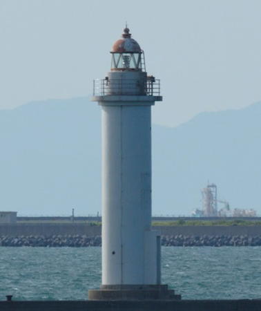
Date unknown. Active; focal plane 18 m (59 ft); green flash every 5 s. 16 m (52 ft) round concrete tower with lantern and gallery. Entire lighthouse is white. S. Katsuragi's photo is at right, Trabas has a good photo, Lighthouse Visit's page has a photo, and Google has a satellite view. Shinmoji (New Moji) is a modern port facing Suo Bay of the Seto Inland Sea. Located at the end of the north breakwater of Sinmozi. Accessible only by boat (the breakwater does not connect to the shore). Site and tower closed. ARLHS JPN-2023; JCG-5287.5; Admiralty M4985; NGA 9754.
Inoura Kō
1970. Active; focal plane 13 m (43 ft); two green flashes every 8 s. 10 m (33 ft) concrete post attached to a square 1-story concrete equipment room. Entire lighthouse is white. Trabas has a closeup photo, FOAL's page for the light has photos, Lighthouse Visit has a page with a closeup photo, and Google has a satellite view and a very distant street view. Located at the north end of a long detached breakwater at Inoura harbor. Accessible only by boat. Site open, tower closed. JCG-5284; Admiralty M4984; NGA 9750.

Kanda and Buzen (Suo Bay) Lighthouses

Kanda Town Lighthouses
* Kanda Kō North Breakwater
Date unknown. Active; focal plane 11 m (36 ft); two red flashes every 8 s. 8.5 m (28 ft) concrete post centered on a square 1-story concrete equipment room. Entire lighthouse is red. Trabas has a photo, Lighthouse Visits has a page with photos, and Google has a satellite view. NGA spells the name Kando. Located at the end of the long north breakwater of Kanda harbor, just south of the Kitakyūshū airport. Accessible by walking the pier. Site open, tower closed. ARLHS JPN-2003; JCG-5278; Admiralty M4982; NGA 9742.
* Kanda Kō East Breakwater
Date unknown. Active; focal plane 11 m (36 ft); two green flashes every 8 s. 7.5 m (25 ft) concrete post centered on a square 1-story concrete equipment room. Entire lighthouse is white. Trabas has a photo, Lighthouse Visits has a page with a photo, and Google has a satellite view. Located at the end of the east breakwater of Kanda harbor. Accessible by walking the pier. Site open, tower closed. JCG-5277; Admiralty M4981; NGA 9738.

Shinmoji North Breakwater Light, Moji-ku, Kitakyūshū, July 2021
Google Maps photo by S. Katsuragi

Buzen City Lighthouse
Unoshima (Unosima) Kō
Date unknown. Active; focal plane 13 m (43 ft); two red flashes every 8 s. 9.5 m (31 ft) concrete post rising from a square 1-story concrete equipment room. Entire lighthouse is red. Trabas has a closeup photo, Lighthouse Visits has a page with a photo, Google has a satellite view. Located on a short, detached outer breakwater at the entrance to Unoshima harbor. Accessible only by boat. Site open, tower closed. ARLHS JPN-2029; JCG-5267; Admiralty M4979; NGA 9730.

Information available on lost lighthouses:

Notable faux lighthouses:

Adjoining pages: North: Western Yamaguchi | East: Northern Ōita | West: Fukuoka Area

Return to the Lighthouse Directory index | Ratings key

Posted June 25, 2007. Checked and revised June 20, 2024. Lighthouses: 28. Site copyright 2024 Russ Rowlett and the University of North Carolina at Chapel Hill.