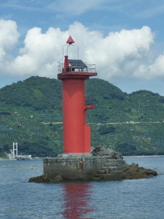
Lighthouses of Japan: Uwajima Area (Western Ehime)

The nation of Japan, known in Japanese as Nihon or Nippon (日本), occupies an archipelago off the east coast of Asia. The four main islands are Hokkaidō in the north, Honshū (the largest), Shikoku in the south, and Kyūshū in the southwest. The country includes thousands of other islands of all sizes; among them the Ryūkyū (Nansei) Islands are a long chain extending to the southwest and including the large island of Okinawa, and the Nanpō Islands are another long chain extending south into the Pacific Ocean. Much of Japan is mountainous but the coastal regions are densely populated and urbanized; the country's population is about 126 million.

Smallest of the Japanese main islands, Shikoku is divided into four prefectures. This page includes lighthouses of western Ehime Prefecture. Most of this coastline faces west on the Bungo Strait (Bungo-Suidō), which runs north and south separating the main islands of Shikoku and Kyūshū. The coastline on the Shikoku side of the strait is quite rugged and complex and the lighthouses tend to be in areas very difficult to reach.

In Japanese the word for a lighthouse is tōdai or toudai (灯台). The words saki and misaki are for capes and headlands, hana ("nose") is a promontory, hantō is a peninsula, shima (also spelled sima or jima) is an island, bae is a reef, iwa or shi is a rocky reef, amase or se is a shoal, wan is a bay, nada is a sound or basin, kaikyō is a strait, kawa is a river, and or minato is a harbor.

Lighthouses in Japan are operated and maintained by the Japanese Coast Guard's Maritime Safety Agency. There is at least one Coast Guard Section Office in each prefecture, often two or more. The office at Uwajima manages the lights in western Ehime.

ARLHS numbers are from the ARLHS World List of Lights. JCG numbers are the Japanese Coast Guard's light list numbers. Admiralty numbers are from volume M of the Admiralty List of Lights & Fog Signals. U.S. NGA List numbers are from Publication 112.

General Sources
Lighthouses in Japan - Ehime
This site covers most of the major lighthouses of Japan.
Lighthouse of Japan - Ehime
Another comprehensive site, in Japanese, with many photos.
Form of a Lighthouse - Ehime
Another site with many photos of Japanese lighthouses, cited below as FOAL.
Lighthouse Visits
This site has photos for many lighthouses in this area.
Online List of Lights - Japan
Photos posted by Alexander Trabas.
Misty's Japanese Lighthouse Tour - Ehime
Photos and a few notes in English for lighthouses in all parts of the country.
Uwajima Navigation Aid Introduction
Information on the lighthouses posted by the Uwajima Coast Guard District.
Meiji Lighthouses of the Sixth Region
Posted by the Sixth Coast Guard Region, information and photos concerning lighthouses built in the Meiji period (1868-1912).
Lighthouses in Ehime Prefecture
Photos by various photographers available from Wikimedia.
Navionics Charts
Navigational chart for Shikoku.

Uwajime West Breakwater Light
West Breakwater Light, Uwajima
Japanese Coast Guard Uwajima Office photo

Ainan Town Lighthouses
#Ninobae Hana (Iyo Fukaura Kō) (1)
Date unknown. Inactive at least since 2015. This was a 7.5 m (25 ft) round concrete tower with a flared top, attached to a 1-story concrete equipment shelter. Entire lighthouse was white. A 2012 photo of the old light is available and Bing has a distant satellite view. A July 2015 photo by the Lighthouse Visit webmaster shows that the light is now on a simple white post (focal plane 9.5 m (31 ft); white light occulting twice every 6 s). Trabas has a photo of the new light. Located at the tip of a promontory on the south side of the entrance to Fukaura harbor. Site open, tower closed. New light: JCG-3124; Admiralty M5611.2; NGA 10508.
* Tengi Hana (Tengibana) (2)
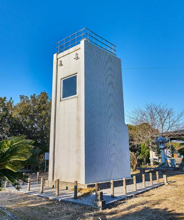
1953 (station established 1949). Active; focal plane 73 m (240 ft); white light, 6 s on, 2 s off; in addition a spotlight (JCG-3126) illuminates a beacon on a reef about 800 m (1/2 mi) southeast. 7.5 m (25 ft) square cylindrical concrete tower with gallery; the spotlight is shown through a square window. Entire lighthouse is white. Yukihiro Matsumura's 2024 photo is at right, Lighthouse Visit has a page with photos, a 2023 photo is available, Syozo Takaha has a 2017 closeup, Trabas has a closeup, Misty's Tour also has photos, and Google has a street view and a satellite view. The station was established with a temporary post. Located on a promontory in Ainan about 20 km (13 mi) west of Sukomo. Accessible by a very crooked mountain road (highway 297); parking available. Site open, tower closed. Site manager: Ashizuri-Uwakai National Park. . ARLHS JPN-639; JCG-3125; Admiralty M5611; NGA 10504.

Open house at Tengi Hana Light, Ainan, January 2024
Instagram photo by Yukihiro Matsumura
* Kōmo Saki
1950. Active; focal plane 142 m (466 ft); white flash every 7 s. 6 m (20 ft) round cylindrical concrete tower with gallery, attached to a small 1-story concrete equipment building. Entire lighthouse is white. Nishinosawa Kobo has the street view seen at right, Lighthouse Visit has a page with photos, Trabas has a closeup, Misty's Tour has several photos, a 2019 closeup is available, the Coast Guard's page has a very distant aerial view, and Google has a satellite view. Kōmo Saki lies at the end of the intricately dissected Iyo peninsula, really an island connected tenuously to the mainland by two narrow isthmuses. Located at the southwestern tip of the peninsula; accessible by a short trail at the end of a very crooked road (highway 34); parking available. Site open, tower closed. Site manager: Ashizuri-Uwakai National Park. . ARLHS JPN-272; JCG-3129; Admiralty M5612; NGA 10492.
Iyo Ka Shima
Date unknown. Active; focal plane 36 m (118 ft); white flash every 4 s. 11 m (36 ft) round white concrete tower with a flared top. Trabas has a closeup photo, the Coast Guard's page has a photo, and Google has a sea view and a satellite view. Located on an island off the northwestern tip of the Iyo peninsula. The light is close to a campground but it would be a difficult scramble to reach it. Site status unknown. ARLHS JPN-193; JCG-5601; Admiralty M5612.1; NGA 10488.
Mabune
Date unknown. Active; focal plane 13 m (43 ft); white light, 3 s on, 3 s off. 10 m (33 ft) round white concrete tower. Trabas has a photo, the Coast Guard's page has a photo, another photo is available, and Google has a satellite view. Located at the tip of a very sharp promontory on the north side of the Iyo Peninsula. Accessible only by boat. Site open, tower closed. JCG-5602; Admiralty M5612.14; NGA 10484.
Kogai Bae
Date unknown. Active; focal plane 13 m (43 ft); two white flashes every 8 s. 11 m (36 ft) round cylindrical white concrete tower. Trabas has a photo, the Coast Guard has a page with a photo, and Google has a satellite view. Located on an islet barely separated from the tip of a promontory about 3 km (2 mi) south of Kashiwa. Accessible only by boat. JCG-5603; Admiralty M5612.2; NGA 10480.
Shiogo (Sioko) Shima (Kuro Bae)
Date unknown. Active; focal plane 19 m (62 ft); white flash every 3 s. 17 m (56 ft) round cylindrical white concrete tower. Kazutoshi Takida has a photo, Trabas has a photo, the Coast Guard has a page with a photo, a distant view is available, and Google has a satellite view. Located on a skerry about 4 km (2.5 mi) east of Kashiwa. Accessible only by boat. Site open, tower closed. ARLHS JPN-2513; JCG-5604; Admiralty M5612.3; NGA 10476.
 

Kōmo Saki Light, Ainan, 2020
Google Maps street view by Nishinosawa Kobo
Yurano Hana (Yura Misaki)
Date unknown. Active; focal plane 93 m (305 ft); white flash every 5 s. 9 m (30 ft) square cylindrical concrete tower. Entire lighthouse is white. A 2022 closeup is available and Google has a satellite view and a closeup street view. Located at the tip of another long and intricate peninsula projecting into the Bungo Strait about 30 km (19 mi) south of Uwajima. Accessible by a lengthy hiking trail. Site open, tower closed. ARLHS JPN-2431; JCG-5606; Admiralty M5613; NGA 10468.

Uwajima City Lighthouses
A city of about 90,000 residents, Uwajima includes more than a third of Shikoku's west coast.

* Suge (Suga) Saki
1950. Active; focal plane 106 m (348 ft); two white flashes every 8 s. 13 m (43 ft) concrete post rising from a small 1-story concrete equipment building. Entire lighthouse is white. The Coast Guard has a page with a photo, Lighthouse Visit has a page with a distant view, Trabas has a distant view, and Google has a closeup photo and a satellite view. Suge Saki is on the north side of the same long and intricate peninsula as the Yurano Hana Light (previous entry). Accessible by road and a short, steep climb, but the webmaster of Misty's Tour needed local information to find it. Site open, tower closed. ARLHS JPN-597; JCG-5607; Admiralty M5614; NGA 10456.
Iyo Takega Shima
Date unknown. Active; focal plane 33 m (108 ft); four white flashes every 16 s. 8 m (26 ft) round white concrete tower. The Coast Guard's page has a closeup photo, Trabas has a distant view and Google has a satellite view. ARLHS misspells the name as "Talega." Located at the western tip of Takega Shima, an island about 4 km (2.5 mi) north of Suge Saki. Site status unknown. ARLHS JPN-194; JCG-5610; Admiralty M5614.1; NGA 10452.
Shono Shima
Date unknown. Active; focal plane 10 m (33 ft); white flash every 4 s. 8 m (26 ft) round cylindrical concrete tower. Entire lighthouse is white. The Coast Guard's page has the photo at right, Trabas has a closeup photo, another photo (about 5/6 of the way down the page, #5611) and a 2015 photo (1/3 the way down the page) are available, and Google has a satellite view. Located on an islet off the tip of a promontory about 10 km (6 mi) west of Tsushimacho. Accessible only by boat. Site status unknown. ARLHS JPN-2419; JCG-5611; Admiralty M5614.2; NGA 10444.

Shono Shima Light, Uwajima
Japanese Coast Guard Uwajima Office photo
Iwamatsu Kō (Usashi Breakwater)
Date unknown. Active; focal plane 11 m (36 ft); green light, 3 s on, 3 s off. 8.5 m concrete post attached to a square 1-story concrete equipment room. Entire lighthouse is white. Trabas has a photo, the Coast Guard's page has a distant photo, and Google has a distant street view across the harbor and a satellite view. Located at the end of the outer breakwater at Iwamatsu, a small port on a deep inlet about 16 km (10 mi) south of Uwajima. It may be possible to reach the light by walking the breakwater. Site status unknown. JCG-5612; Admiralty M5614.3; NGA 10448.
Watano Se
Date unknown. Active; focal plane about 12 m (39 ft); light characteristic unknown. Approx. 12 m (39 ft) round cylindrical concrete tower painted black with one red horizontal band. Takashi Toyoda has a photo and Trabas has a distant view but Bing has only a fuzzy satellite view. Located on a shoal about 2 km (1.25 mi) west of Takega Shima. Accessible only by boat. Site open, tower closed. JCG-5609; Admiralty M5614.52.
Noto Saki (Aka Bae)
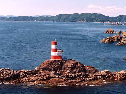
Date unknown. Active; focal plane 16 m (52 ft); three white flashes every 13. 9 m (30 ft) round cylindrical concrete tower rising from a small 1-story concrete equipment building. Lighthouse painted with red and white horizontal bands. A Coast Guard photo is at right, a Coast Guard page has another photo, Trabas has a photo, Chie Ikeda has a photo, and Google has a satellite view. Located on a skerry just off the coast about 15 km (9 mi) southwest of Uwajima. Accessible only by boat. Site status unknown. ARLHS JPN-2409; JCG-5613; Admiralty M5614.34; NGA 10440.
Otoshi Hana (Otoshibana)
Date unknown. Active; focal plane 9.5 m (31 ft); one short and one long green flash every 8 s. 9.5 m (31 ft) round concrete tower with gallery, mounted on a round concrete pier. Entire lighthouse is green. Trabas has a good photo and Google has a satellite view. Located just off a promontory about 1.2 km (3/4 mi) east of Komobuchi. Accessible only by boat. Site open, tower closed. JCG-5614; Admiralty M5614.4; NGA 10420.
Noto Saki
Noto Saki Light, Uwajima
Japanese Coast Guard Sixth Region photo (no longer online)
Hiburi Shima
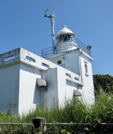
1958. Active; focal plane 125 m (410 ft); two white flashes every 20 s. 10 m (33 ft) square cylindrical concrete tower with lantern and gallery, rising from a 1-story concrete keeper's house or equipment building. Entire lighthouse is white. Jun Sato's 2023 photo is at right, Tomio Umezawa has a 2012 photo, a page for the lighthouse has three good photos, the Coast Guard's page has a very distant aerial view, and Google has a satellite view. Hiburi Shima is an inhabited island in Bungo Strait about 27 km (17 mi) west southwest of Uwajima. The island lies close to the main shipping channel of the strait, making this an important light station. Located at the western tip of the island. Ferry service is available and the lighthouse is accessible by a short hike. Site open, tower closed. ARLHS JPN-110; JCG-5615; Admiralty M5614.5; NGA 10436.
Uwa Ka Shima
Date unknown. Active; focal plane 129 m (423 ft); white light, 3 s on, 3 s off. 10 m (33 ft) square cylindrical white concrete tower. A closeup 2024 photo is available, Lighthouse Visit has a page with a distant view, Trabas has a very distant view, the Coast Guard page also has a very distant view, and Google has a satellite view. This lighthouse marks the beginning of the approach to the harbor of Uwajima, the principal port on Shikoku's southwestern coast. Located atop a small but high island about 18 km (11 mi) west of Uwajima. The lighthouse should be accessible by a short hike from the village on the island. Site status unknown. ARLHS JPN-734; JCG-5616; Admiralty M5615.6; NGA 10424.
Oko Shima
Date unknown. Active; focal plane 61 m (200 ft); white flash every 3 s. 8.5 m (28 ft) round white concrete tower. Trabas has a photo, Chie Ikeda has a photo, a distant view from the sea is available, the Coast Guard has a page for the light, and Google has a satellite view. Located atop an uninhabited island about 13 km (8 mi) west of Uwajima. Accessible only by boat. Site status unknown. JCG-5618; Admiralty M5615; NGA 10428.
Bozu Bae
Date unknown. Active; focal plane 10 m (33 ft); one longshort and one long green flash every 8 s. 8 m (26 ft) round cylindrical concrete tower, painted green. Trabas has a photo, the Coast Guard page has a closeup photo, and Google has a satellite view. Located off the southwest tip of Takashima, an island about 8 km (5 mi) west southwest of Uwajima. Accessible only by boat. Site open, tower closed. JCG-5623; Admiralty M5616.4; NGA 10360.
[Dō (Doga) Saki]
Date unknown. Active; focal plane 28 m (92 ft); white flash every 4 s. 7.5 m (25 ft) round concrete tower attached to an equipment shelter. Trabas has a closeup photo, the Coast Guard page has a view from the sea, a closeup is available, and Google has a satellite view. Located on a sharp cape on the south side of the entrance to Uwajima harbor. Site open, tower closed. ARLHS JPN-054; JCG-5625; Admiralty M5618; NGA 10356.

Hiburi Shima Light, Uwajima, July 2023
Google Maps photo by Jun Sato
* Uwajima Kō West Breakwater
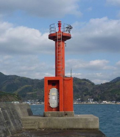
Date unknown. Active; focal plane 10 m (33 ft); red flash every 5 s. 8.5 m (28 ft) concrete post attached to a 1-story concrete equipment room. Entire lighthouse is red. A Coast Guard photo is at the top of this page, Trabas has a closeup photo, Lighthouse Visit has photos (bottom of the page), a 2019 photo is available, and Google has a street view and a satellite view. Located at the end of a breakwater protecting Uwajima harbor. Accessible by walking the pier. Site open, tower closed. ARLHS JPN-2426; JCG-5626.5; Admiralty M5619.2; NGA 10348.
Hikide Hana
Date unknown. Active; focal plane 15 m (49 ft); white light occulting once every 4 s. 13 m (43 ft) round white concrete tower with double gallery. Trabas has a closeup photo, Lighthouse Visit has a page for the lighthouse, the Coast Guard has a page with a photo, and Google has a satellite view. Located on a promontory on the north side of the entrance to Uwajima harbor. Probably accessible only by boat. Site open, tower closed. ARLHS JPN-2370; JCG-5627; Admiralty M5619.4; NGA 10412.
Ora Saki (Orasaki)
Date unknown. Active; focal plane 30 m (98 ft); white light, 3 s on, 3 s off. 11 m (36 ft) round white concrete tower. Trabas has a photo, the Coast Guard has a page with a photo, and Google has a satellite view. Located on the tip of a long peninsula at the northern entrance to the bay of Uwajima, about 10 km (6 mi) west northwest of the city. Site status unknown. JCG-5630; Admiralty M5620; NGA 10408.

Seiyo City Lighthouses
Iyu Mizukoshi Shima
Date unknown. Active; focal plane 16 m (52 ft); white flash every 5 s. 8 m (26 ft) post rising from a square 1-story equipment shelter. Entire lighthouse is white. Trabas has a good photo, the Coast Guard page has a photo, a 2023 photo is available, another photo (halfway down the page) is available and Google has an indistinct satellite view. Located atop an islet in Hokezu Bay, which separates Uwajima from Seiyo. Accessible only by boat. Site open, tower closed. JCG-5632; Admiralty M5621.4; NGA 10404.
* Osaki Hana
Date unknown. Active; focal plane 107 m (351 ft); white flash every 5 s; also a spotlight (JCG-5634) illuminating a nearby reef. 8.5 m (28 ft) rectangular cylindrical white concrete tower. Nishinosawa Kobo has the street view at right, Trabas has a closeup photo, the Coast Guard page has an aerial view, and Google has a street view and a satellite view. The monument next to the lighthouse honors the poet Kazuko, who was born nearby. Located on the tip of a rugged peninsula at the western end of Seiyo city. Accessible by road; parking is available. Site open, tower closed. JCG-5633; Admiralty M5622; NGA 10400.
Takashima (Okuti Wan) South Breakwater
Date unknown. Active; focal plane 12 m (39 ft); green flash every 3 s. 9.5 m (31 ft) concrete post attached to a square 1-story concrete equipment shelter. Entire lighthouse is white. Trabas has a photo, the Coast Guard page has a closeup, a lovely distant view is available, and Google has a sea view, a distant street view and a satellite view. Located on a long breakwater extending from Takashima, an island off the northside of Osaki Hana. Accessible only by boat. Site status unknown. JCG-5636; Admiralty M5622.5; NGA 10396.
Takashima (Okuti Wan)
Date unknown. Active; focal plane 38 m (125 ft); three white flashes every 14 s. 8.5 m (28 ft) round white concrete tower. The Coast Guard page has a closeup photo and Google has a satellite view. Located at the western tip of Takashima. Accessible only by boat. Site status unknown. ARLHS JPN-2414; JCG-5637; Admiralty M5622.4; NGA 10392.

Osaki Hana Light, Seiyo, February 2020
Google Maps street view by Nishinosawa Kobo

Yawatahama City Lighthouses
Yawatahama is the terminal for ferries crossing Bungo Strait to Usuki and Beppu, Kyūshū. The city is at the head of a fjord-like inlet at the northeastern corner of Bungo Strait.
Ko Shima (Kojima)
Date unknown. Active; focal plane 12 m (39 ft); white flash every 5 s. 11 m (36 ft) round white concrete tower with gallery. The Coast Guard page has a photo, Trabas has a photo, a 2022 closeup is available, and Google has a satellite view. Located on an islet about 15 km (9 mi) southwest of Yawatahama. Accessible only by boat. Site open, tower closed. ARLHS JPN-2392; JCG-5638; Admiralty M5622.7; NGA 10388.
Sa Shima
Date unknown. Active; focal plane 58 m (190 ft); white flash every 3 s. 9 m (30 ft) round concrete tower attached to a 1-story concrete equipment building. Entire lighthouse is white. Trabas has a distant view, Lighthouse Visits has photos (last lighthouse on the page), and Google has a satellite view. Located on an island about 8 km (5 mi) west southwest of Yawatahama. Accessible only by boat. Site open, tower closed. ARLHS JPN-2415; JCG-5641; Admiralty M5623; NGA 10372.
Zeku Iwa
Date unknown. Active; focal plane 13 m (43 ft); two red flashes, one short and one long, every 8 s. 10 m (33 ft) round cylindrical concrete tower. Entire lighthouse is red. The Coast Guard's photo is at right, Trabas has a photo, Kenichiro Asai has a 2021 view from the sea, another view from the sea is available, Lighthouse Visits has photos (second lighthouse on the page), and Google has an indistinct satellite view. Located on a skerry at the tip of the promontory on the south side of the approach to Yawatahama. Accessible only by boat. Site open, tower closed. JCG-5640; Admiralty M5623.4; NGA 10376.
* Yawatahama Kō
Date unknown. Active; focal plane 11 m (36 ft); green light occulting once every 4 s. 8.5 m (28 ft) concrete post rising from a square 1-story concrete equipment shelter. Entire lighthouse is white. Trabas has a closeup photo, Lighthouse Visits has photos (first lighthouse on the page), a view from the sea is available and Google has a street view and a satellite view. Located at the end of a breakwater on the north side of the entrance to Yawatahama harbor. Accessible by walking the pier. Site open, tower closed. ARLHS JPN-2429; JCG-5639.6; Admiralty M5623.5; NGA 10378.

Information available on lost lighthouses:


Zeku Iwa Light, Yawatahama
Japanese Coast Guard Uwajima Office photo
Notable faux lighthouses:

Adjoining pages: North: Central Ehime | South: Southern Kōchi | West: Southern Ōita

Return to the Lighthouse Directory index | Ratings key

Posted May 28, 2007. Checked and revised February 18, 2024. Lighthouses: 31. Site copyright 2024 Russ Rowlett and the University of North Carolina at Chapel Hill.