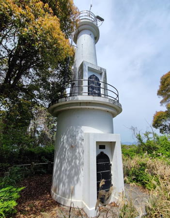
Lighthouses of Japan: Matsuyama Area (Central Ehime)

The nation of Japan, known in Japanese as Nihon or Nippon (日本), occupies an archipelago off the east coast of Asia. The four main islands are Hokkaidō in the north, Honshū (the largest), Shikoku in the south, and Kyūshū in the southwest. The country includes thousands of other islands of all sizes; among them the Ryūkyū (Nansei) Islands are a long chain extending to the southwest and including the large island of Okinawa, and the Nanpō Islands are another long chain extending south into the Pacific Ocean. Much of Japan is mountainous but the coastal regions are densely populated and urbanized; the country's population is about 126 million.

Smallest of the Japanese main islands, Shikoku is divided into four prefectures. This page includes lighthouses of central Ehime Prefecture, a coastline facing north on the Seto Inland Sea. This is a scenic and well populated coast with numerous harbors.

In Japanese the word for a lighthouse is tōdai or toudai (灯台). The words saki and misaki are for capes and headlands, hana ("nose") is a promontory, hantō is a peninsula, shima (also spelled sima or jima) is an island, bae is a reef, iwa or shi is a rocky reef, amase or se is a shoal, wan is a bay, nada is a sound or basin, kaikyō is a strait, kawa is a river, and or minato is a harbor.

Lighthouses in Japan are operated and maintained by the Japanese Coast Guard's Maritime Safety Agency. There is at least one Coast Guard Section Office in each prefecture, often two or more. Lighthouses in this part of Ehime are managed by the office at Matsuyama.

ARLHS numbers are from the ARLHS World List of Lights. JCG numbers are the Japanese Coast Guard's light list numbers. Admiralty numbers are from volume M of the Admiralty List of Lights & Fog Signals. U.S. NGA List numbers are from Publication 112.

General Sources
Lighthouses in Japan - Ehime
This site covers most of the major lighthouses of Japan.
Lighthouse of Japan - Ehime
Another comprehensive site, in Japanese, with many photos.
Form of a Lighthouse - Ehime
Another site with many photos of Japanese lighthouses, cited below as FOAL.
Lighthouse Visits
This site has photos for many lighthouses in this area.
Online List of Lights - Japan
Photos by various photographers posted by Alexander Trabas. For the lights on this page most of the photos are by Trabas with Katsuna Islands photos by Michael Boucher.
Misty's Japanese Lighthouse Tour - Ehime
Photos and a few notes in English for lighthouses in all parts of the country.
Meiji Lighthouses of the Sixth Region
Posted by the Sixth Coast Guard Region, information and photos concerning lighthouses built during the Meiji period (1868-1912).
Lighthouses in Ehime Prefecture
Photos by various photographers available from Wikimedia.
Navionics Charts
Navigational chart for Shikoku.

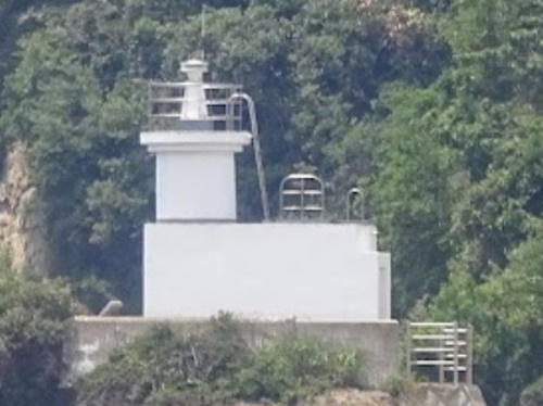
Tsuru Shima Light
Tsurushima Light, Matsuyama
Japanese Coast Guard Sixth Region photo
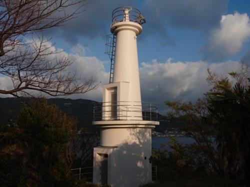
Iyo Bay Lighthouses

Iyo Bay is the westernmost of the three major basins of the Seto Inland Sea, bounded by Shikoku on the southeast, Kyūshū on the southwest, and Honshū on the north.

Ikata Town (Sadamisaki Peninsula) Lighthouses
The Sadamisaki Peninsula is a 32 km (20 mi) long finger of land pointing from the western tip of Shikoku. Narrow and mountainous, the scenic peninsula separates the Bungo Strait to the south from Iyo Bay to the north. Highway 197 runs the length of the peninsula.

* Murono (Muroga) Hana
1972. Active; focal plane 31 m (102 ft); white light, 3 s on, 3 s off. 12 m (39 ft) two-stage round concrete tower, the lower part cylindrical and the upper part conical. Entire lighthouse is white. S. Katsuragi's photo is at right, Toshiyuki Nishizaki has a 2017 photo, Lighthouse-Japan.com has a page with good photos, FOAL's page also has photos, Trabas has a photo, Lighthouse Visit has a page, and Google has a satellite view. The lighthouse stands on a ridge above an Ikata town park. Located on a promontory on the west side of the entrance to Ikata, about 8 km (5 mi) west of Yawatahama, near the base of the Sadamisaki peninsula. Accessible by road but parking is quite limited. Site open, tower closed. ARLHS JPN-378; JCG-5642; Admiralty M5623.6; NGA 10380.
* Mekko Hana (Taka Bae)
Date unknown. Active; focal plane 64 m (210 ft); white light occulting twice every 8 s. 12 m (39 ft) round white concrete tower. Lighthouse-Japan.com has a page with closeup photos, Lighthouse Visit also has good photos, FOAL's page has distant views, Trabas has a photo, a 2019 photo is available, and Google has a satellite view. Located atop the end of a very narrow peninsula projecting from the south side of the Sadamisaki peninsula about 10 km (6 mi) west of Yawatahama. Accessible by a hike of about 900 m (0.56 mi); the trailhead is marked and parking is available. Site status unknown. ARLHS JPN-341; JCG-5643; Admiralty M5624.5; NGA 10384.

Murano Hana Light, Ikata, November 2020
Google Maps photo by S. Katsuragi
* Sadamisaki Kō
1963. Active; focal plane 15 m (49 ft); continuous green light with a more intense flash every 6 s. 9.5 m (31 ft) concrete post rising from a square 1-story concrete equipment room. Entire lighthouse is white. FOAL's page has a closeup photo, Trabas has a closeup photo, Lighthouse Visit has a page with photos, and Google has a distant street view and a satellite view of the light. Located at the end of the main breakwater of Sadamisaki harbor, on the south side of the peninsula, about 5 km (3 mi) northeast of the point of the cape. Accessible by walking the pier. Site open, tower closed. JCG-5647; Admiralty M5625.6; NGA 10465.
* Sada Misaki
1918. Active; focal plane 49 m (161 ft); three white flashes every 20 s; in addition, a spotlight (JCG-4968) illuminates the Ogon Bae reef to the south. 18 m (59 ft) octagonal cylindrical concrete tower with lantern and gallery, rising from a 1-story concrete keeper's house. Entire lighthouse is white. A photo is at right, Lighthouse-Japan.com has a page with several good photos, FOAL's page has several photos, Lighthouse Visit has a page, Trabas has a photo, another good photo from the land side is available, Wikimedia has several photos, the Coast Guard has a spectacular photo of the lighthouse and spotlight in action, and Google has a satellite view and a distant street view. This is one of Japan's Famous Fifty Lighthouses. Although many lighthouses have lovely locations, few command a view as spectacular as this one. The Sadamisaki peninsula is 32 km (20 mi) long and never more than a few kilometers wide. It projects into the Inland Sea, separating Iyo Bay on the north from Uwa Bay on the south. At its tip, the lighthouse is surrounded by water in all directions. Accessible by hiking trail from the parking area at the end of the very scenic highway 197. Many visitors probably stop at an observation platform that has a spectacular view. Those who continue find that the access path to the lighthouse ends in a steep stairway. Site open, tower closed. . ARLHS JPN-519; JCG-4967; Admiralty M5424; NGA 9296.
* Mimai Saki
1976. Active; focal plane 73 m (240 ft); white light, 3 s on, 3 s off. 10 m (33 ft) two-stage round concrete tower with double gallery. Entire lighthouse is white. Trabas has a closeup photo, Lighthouse-Japan.com has a page with several photos, FOAL's page has several closeup photos, Lighthouse Visit has a page, and Google has a street view and a satellite view. Located on a sharp promontory on the north side of the Sadamisaki peninsula about 2/3 of the way to the cape. Accessible by road (highway 255); there's no parking at the lighthouse but there is a small turnout about 100 m to the west. Site open, tower closed. ARLHS JPN-354; JCG-4966; Admiralty M5426; NGA 9292.
* Mitsukue (Mitukue) Kō (2)
Date unknown (station established 1960). Active; focal plane 13 m (43 ft); red light, 3 s on, 3 s off. 9 m (30 ft) concrete post rising from a square 1-story concrete equipment room. Entire lighthouse is red. Trabas has a closeup photo, FOAL's page for the light has excellent photos, Lighthouse Visit has a page, and Google has a street view across the harbor and a satellite view. NGA formerly listed a 7 m (23 ft) skeletal tower at this location. Located at the end of the west breakwater of Mitsukue harbor. Accessible by walking the pier. Site open, tower closed. JCG-4965; Admiralty M5427; NGA 9288.

Sada Misaki Light, Ikata, March 2020
Google Maps photo by Aぱっきゃまら
Fusuma (Husuma) Hana
1956. Active; focal plane 60 m (197 ft); white flash every 10 s. 9 m (30 ft) round cylindrical concrete tower with lantern and gallery. Entire lighthouse is white. Lighthouse-Japan.com has a page with good photos, Trabas has a photo of the light in action, additional photos are available on FOAL's page for the lighthouse, Lighthouse Visit has a page, Misty's Tour has another photo, and Google has a satellite view. Located on a sharp promontory on the north side of the Sadamisaki peninsula about 1/3 of the way to the cape and 2.5 km (1.5 mi) northeast of the Mitsukue harbor. Accessible by a winding mountain road and a short walk; a faint trail leads from a hairpin turn in the road. Site open, tower closed. ARLHS JPN-145; JCG-4964; Admiralty M5427.5; NGA 9284.

Ōzu City Lighthouse
Ao Shima (Iyo Aoshima)
Date unknown. Active; focal plane 102 m (335 ft); two white flashes every 8 s. 12 m (39 ft) round white concrete tower. A visitor has a closeup photo, a closeup of the base of the tower is available, and Google has a satellite view. Located atop an isolated high island in Iyo Bay about 20 km (12.5 mi) west of Iyo. Accessible only by boat. Site status unknown. ARLHS JPN-192; JCG-4915; Admiralty M5644.4; NGA 9144.

Iyo City Lighthouses
* Iyo Toyota (Iyotoyota) Kō
Date unknown. Active; focal plane 16 m (52 ft); continuous red light with a more intense flash every 6 s. 9.5 m (31 ft) concrete post attached to a 1-story concrete equipment room. Entire lighthouse is red. Trabas has a closeup photo, Lighthouse Visit has a page for the light, and Google has a satellite view and a street view across the harbor. Located at the end of the main breakwater of the Toyota Fishing Harbor at Shimonada, southwest of Iyo. Accessible by walking the pier (a long walk). Site open, tower closed. JCG-4960.5; Admiralty M5430; NGA 9270.
* Iyo (Futami) Kaminada Kō
Date unknown. Active; focal plane 13 m (43 ft); red light, 2 s on, 2 s off; also a continuous white spotlight (JCG-4959) illuminates the breakwater on the other side of the entrance. 9.5 m (31 ft) round hourglass-shaped concrete tower. Entire lighthouse is red. Trabas has a closeup photo, Lighthouse Visit has a page for the lighthouse, and Google has a street view and a satellite view. Located at the end of the west breakwater at Kaminada harbor, southwest of Iyo. Accessible by walking the pier. Site open, tower closed. JCG-4958; Admiralty M5430.5; NGA 9268.
* [Gunchu (Guntyu) Kō (1)]
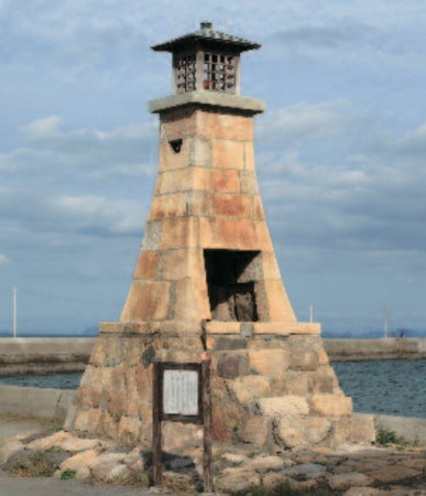
Date unknown (around 1870?). Inactive since 1957. Approx. 7.5 m (25 ft) square tapered unpainted stone tower with a traditional box lantern. A photo is at right, additional photos are available, and Google has a street view and a satellite view. Said to date from the Meiji era, this lighthouse originally stood at the end of a pier but was relocated to its present location in 1912. It continued to carry a light until 1957, when the harbor was rebuilt. There is a modern post light (focal plane 13 m (43 ft); two red flashes every 7 s) at the end of the extended breakwater; Trabas also has a photo. Located on the waterfront of the traditional Gunchu harbor in Iyo. Site open, tower closed. Modern light: JCG-4957; Admiralty M5431; NGA 9264.

Gunchu Kō Light, Iyo
Iyo City photo

Matsuyama City Lighthouses

Matsuyama ("Pine Mountain") is the capital of Ehime Prefecture; it has a population of more than 500,000.

Matsuyama Harbor Lighthouses
* Masaki Kō
Date unknown. Active; focal plane 12 m (39 ft); red flash every 3 s. 8 m (26 ft) concrete post attached to a 1-story concrete equipment room. Entire lighthouse is red. Trabas has a closeup photo, Lighthouse Visit has a page for the lighthouse, and Google has a satellite view and a distant street view. Located at the end of the breakwater of Masaki Harbor in southern Matsuyama. Accessible by walking the pier. Site open, tower closed. JCG-4956; Admiralty M5432; NGA 9260.
Nishi Habuhakuchi Breakwater
Date unknown. Active; focal plane 13 m (43 ft); red flash every 3 s. 11 m (36 ft) concrete post attached to a 1-story concrete equipment room. Entire lighthouse is red. Trabas has a closeup photo and Google has a satellite view and a very distant street view. Located at the north end of the detached breakwater of Nichi Habuhakuchi harbor, in the southern part of the city of Matsuyama. Accessible only by boat. Site open, tower closed. JCG-4955; Admiralty M5432.8; NGA 9256.
Matsuyama Kō Outer Breakwater
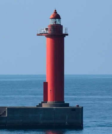
Date unknown. Active; focal plane 18 m (56 ft); two red flashes every 7 s. 16 m (52 ft) round cylindrical concrete tower with lantern and gallery. Entire lighthouse is red. S. Katsuragi's photo is at right, a sunset photo is available, Trabas has a Boucher's photo, and Google has a sea view and a satellite view. Located at the north end of the detached outer breakwater of Matsuyama, the capital city of Ehime prefecture. Accessible only by boat. Site and tower closed. JCG-4947.5; Admiralty M5433.8; NGA 9240.
* #Matsuyama Kō Inner Breakwater (1)
Date unknown. Replaced in 2018. This was an 8.5 m (28 ft) concrete post light attached to a 1-story concrete equipment room. Entire lighthouse was red. Lighthouse Visit has a page for the light and Google has a 2016 sea view. It was replaced with a light on a simple post (focal plane 11 m (36 ft); red light, 2 s on, 2 s off) seen in Boucher's closeup photo and Google's satellite view. Located at the end of a short breakwater at the entrance to Matsuyama's inner harbor. Accessible by walking the pier. Site open, tower closed. Active light: JCG-4948; Admiralty M5434; NGA 9244.
**** Tsurushima (Turu Shima)
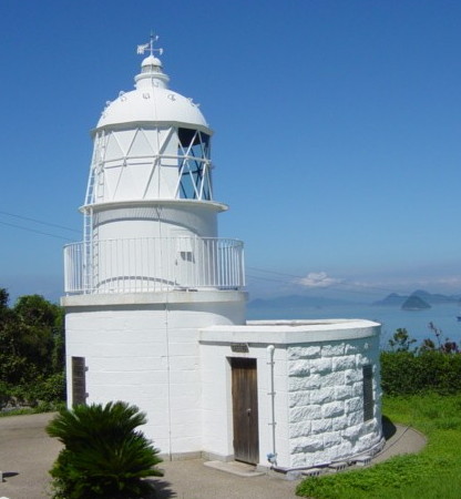
1873 (Richard Henry Brunton). Active; focal plane 58 m (190 ft); flash every 8 s, alternately red and white. 10 m (33 ft) round stone tower rising from a semicircular stone keeper's house. Entire lighthouse painted white. A photo is at the top of this page, the Matsuyama Coast Guard District has a great photo, Lighthouse-Japan.com has a page with good photos, Wikimedia has a closeup photo, Lighthouse Visit has photos, Akihiko Fujii has a 2023 closeup, Trabas has Boucher's distant view, Yumi Nosuke has a street view, and a Google satellite view is available. The keeper's house and other buildings of the station gradually fell into ruins after the lighthouse was automated in 1955. In 1995 the city of Matsuyama acquired all of the station except the light tower and carefully restored the buildings to their original appearance. Tsurushima is a kidney-shaped island about 7 km (4 mi) west of Matsuyama. Ferries sail to the island in early morning and return in late afternoon as visitors are expected to spend the day; be sure to pack a picnic lunch. Located on a hillside above the town, at the northern end of the island. Site open, keeper's house and tower open to guided tours. . ARLHS JPN-696; JCG-4901; Admiralty M5436; NGA 9128.

Outer Breakwater Light, Matsuyama, November 2022
Google Maps photo by S. Katsuragi

Katsuna Islands Lighthouses
The Katsuna Islands stretch northwestward from Matsuyama across the Seto Inland Sea forming the northern edge of Iyo Bay.

Yuri Shima
Date unknown. Active; focal plane 32 m (105 ft); three white flashes every 12 s. 12 m (39 ft) concrete post rising from a round 1-story concrete equipment room. Entire lighthouse is white. A 2021 photo is available, Trabas has Boucher's very distant view, and Google has a satellite view. Located on the southeastern tip of Yuri Shima, an uninhabited island about 15 km (9 mi) west of the Matsuyama waterfront. Accessible only by boat. Site status unknown. JCG-4914; Admiralty M5645; NGA 9140.
[Oichi Shima]
Date unknown. Active; focal plane 14 m (46 ft); white flash every 10 s. 10 m (33 ft) concrete post with a small equipment shelter mounted on a large round concrete pier. Trabas has Boucher's photo, Kenichiro Asai has a photo, another photo is available, and Google has a satellite view. Located on the southeast side of Oichi Shima, an uninhabited island about 20 km (13 mi) northwest of the Matsuyama waterfront. Accessible only by boat. Site status unknown. JCG-4904; Admiralty M5651.6; NGA 9136.
Nenashi Sho (Nenasi Syo)
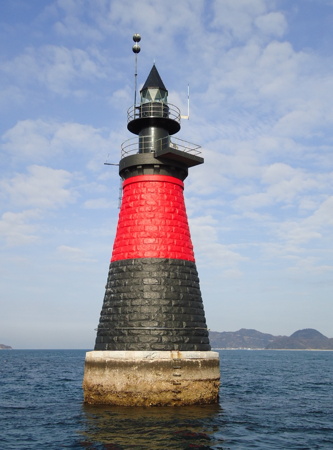
1902. Active; focal plane 17 m (56 ft); two white flashes every 5 s. 17 m (56 ft) round strongly conical stone tower with lantern and gallery, mounted on a round pier. Lighthouse painted black with a red horizontal band. A closeup photo is at right, Trabas has Boucher's photo, Chie Ikeda has a 2021 photo, and Google has a satellite view. This lighthouse is on the border between Ehime and Yamaguchi prefectures and sources disagree as to its placement. Located on a shoal off the eastern tip of Yashiro Shima, at the northeastern corner of Iyo Bay. Accessible only by boat. Site open, tower closed. JCG-4929; Admiralty M5646; NGA 9188.
Aburitori Se
Date unknown. Active; focal plane 12 m (39 ft); two green flashes, one short and one long, every 8 s. 9 m (30 ft) round hourglass-shaped concrete tower mounted on a round concrete pier. Entire lighthouse is green. Lighthouse Visits has a photo (second lighthouse on the page), another photo and a drone view are available, and Google has a satellite view. Located on a reef off the southeast coast of Tsuwaji Shima, the northwesternmost of the Katsuna Islands. Accessible only by boat. Site open, tower closed. JCG-4928; Admiralty M5646.5; NGA 9184.

Nenashi Sho Light, Seto Inland Sea
Japanese Coast Guard Matsuyama Office photo
Kazekiri Hana
Date unknown. Active; focal plane 12 m (39 ft); white light occulting twice every 6 s. 8.5 m (28 ft) concrete post mounted on a square 1-story concrete equipment shelter. Entire lighthouse is white. Trabas has Boucher's photo, a closeup photo is available, and Google has a satellite view. Located at the extreme northeastern tip of Nuwa Shima. Probably accessible only by boat. Site open, tower closed. ARLHS JPN-2390; JCG-4925; Admiralty M5649; NGA 9172.
Kudako Shima
1903. Active; focal plane 57 m (187 ft); white light, 3 s on, 3 s off. 11 m (36 ft) round stone tower with lantern and gallery, painted white. A Coast Guard photo is at right, Trabas has Boucher's distant view, and Google has a satellite view. Located on a small island about 1.5 km (1 mi) west of Heyano Hana. Accessible only by boat. Site status unknown. ARLHS JPN-296; JCG-4926; Admiralty M5650; NGA 9176.
Heyano Hana
1971. Active; focal plane 53 m (174 ft); three white flashes every 13 s. 11.5 m (38 ft) two-stage round concrete tower with double gallery. Entire lighthouse is white. A closeup 2023 photo is available, Lighthouse Visit has a photo (first lighthouse on the page), and Google has a satellite view. Located on the western tip of the inhabited island of Nakajima in the Inland Sea about 16 km (10 mi) northwest of Matsuyama. Ferry service to the island is available and the lighthouse is accessible by a hiking trail from the west end of the harbor. Site open, tower closed. ARLHS JPN-106; JCG-4927; Admiralty M5651; NGA 9180.
Fuguri (Huguri) Iwa
Date unknown. Active; focal plane 14 m (46 ft); six quick white flashes and one long white flash every 15 s. 11 m (36 ft) round concrete tower, mounted on a round concrete pier. Upper half of the tower painted yellow, lower half black. Trabas has Boucher's closeup photo, Yumi Nosuke has a distant view, and Google has a satellite view. Located on a shoal off the southern tip of the island of Nakajima. Accessible only by boat. Site open, tower closed. JCG-4903; Admiralty M5651.7; NGA 9132.

Kudako Shima Light, Matsuyama, posted to Twitter October 2018
Japanese Coast Guard photo
Uta Saki
Date unknown. Active; focal plane 14 m (46 ft); white flash every 4 s. 12 m (39 ft) round cylindrical concrete tower. Entire lighthouse is white. Lighthouse Visit has a photo (second lighthouse on the page), Trabas has Boucher's photo, and Google has a satellite view. Located at the extreme northern tip of the island of Nakajima. Accessible only by boat. Site open, tower closed. ARLHS JPN-2425; JCG-4671; Admiralty M5651.3; NGA 8900.
Ho Saki
Date unknown. Active; focal plane 12 m (39 ft); two green flashes, one short and one long, every 8 s. 8.5 m (28 ft) round concrete tower mounted on a round concrete pier. Entire lighthouse is green. Trabas has Boucher's photo, a 2021 sea view is available, and Google has a satellite view. Located just off the point of Ho Saki, the southeastern tip of Muzuki Shima. Accessible only by boat. Site open, tower closed. JCG-4629; Admiralty M5651.8; NGA 8780.
Nogutsuna (Nobutsuna, Nokutuna) Shima
Date unknown. Active; focal plane 13 m (43 ft); white light occulting twice every 12 s. 6.5 m (21 ft) round cylindrical concrete tower, attached to a 1-story equipment shelter and mounted on a large stone pier. Entire lighthouse is white. Okahara Isao's photo is at right, Trabas has Boucher's photo, the Coast Guard has a small photo (upper right photo in the group), and Google has a satellite view. Located at the southeastern tip of Nogutsuna Shima. Accessible only by boat. Site open, tower closed. ARLHS JPN-2408; JCG-4628; Admiralty M5652; NGA 8776.
Ai Shima (Aijima)
Date unknown. Active; focal plane 65 m (213 ft); white light occulting once every 4 s. 11 m (36 ft) round white concrete tower. A 2022 closeup photo is available, Trabas has Boucher's distant view, and Google has a satellite view. Located on a small but inhabited island in Aki Bay about 13 km (8 mi) northwest of Hojo. Accessible only by boat. Site status unknown, probably accessible by a hiking trail from the village. ARLHS JPN-006; JCG-4669; Admiralty M5445; NGA 8896.

Uta Saki Light, Matsuyama, June 2023
Google Maps photo by Okahara Isao

Northern Matsuyama Lighthouses
Tsumuri (Tumuri) Saki
1972. Active; focal plane 47 m (154 ft); two white flashes every 6 s. 11 m (36 ft) round concrete tower. Entire lighthouse is white. Trabas has Boucher's closeup photo, Lighthouse Visit has a page for the lighthouse, and Google has a satellite view. Located at the northeastern tip of the island of Gogo Shima about 8 km (5 mi) southwest of Hojo. Site status unknown. ARLHS JPN-691; JCG-4641; Admiralty M5437; NGA 8812.
Horie West Harbor Breakwater
Date unknown. Active; focal plane 11 m (36 ft); green flash every 4 s. 8.5 m (28 ft) concrete post light attached to a square 1-story concrete equipment building. Entire lighthouse is white. Trabas has a photo, Lighthouse Visit has a page for the lighthouse, and Google has a satellite view and a distant street view. Located on the detached breakwater of a small boat harbor at Horie in Matsuyama. Accessible only by boat, but easily seen from shore. Site open, tower closed. ARLHS JPN-2373; JCG-4640; Admiralty M5439; NGA 8810.
#Hojo (Hozyo) Kō
Date unknown. Inactive since 2018 and since removed. This was a 10 m (32 ft) concrete post attached to a square 1-story concrete equipment building. Entire lighthouse is white. FOAL's page has photos taken in 2013, Lighthouse Visit also has a page for the lighthouse, and Google has a 2012 street view. Google's satellite view confirms the removqal of the lighthouse. Located on the north side of the entrance to Hojo harbor. Accessible by walking the pier. Site open, tower closed. ARLHS JPN-2375; ex-JCG-4637; ex-Admiralty M5442; NGA 8800.
* Hazumano (Hazuma No) Hana
1966. Active; focal plane 62 m (203 ft); white light occulting once every 8 s. 10 m (33 ft) concrete post light rising from a square 1-story concrete equipment building. Entire lighthouse is white. Located on the tip of a sharp promontory on the mainland of Shikoku about 3 km (2 mi) north of Hojo. Trabas has a photo, FOAL's page for the lighthouse has photos, Lighthouse Visit also has a page, and Google has a satellite view. The lighthouse is in a city park; parking is available. Site open, tower closed. ARLHS JPN-097; JCG-4636; Admiralty M5444; NGA 8796.
Shiode Iso
Date unknown. Active; focal plane 15 m (49 ft); one short and one long red flash every 8 s. 12 m (39 ft) round cylindrical concrete tower with double gallery, mounted on a round concrete pier. Entire lighthouse is red. Lighthouse Visit has a photo, another photo is available, Trabas has a foggy photo, and Google has a satellite view. Located on a reef about 1 km (0.6 mi) northwest of Asanami. Accessible only by boat, but easy to see from shore. Site open, tower closed. JCG-4635; Admiralty M5447; NGA 8792.

Tsumari Saki Light, Matsuyama, April 2023
Google Maps photo by すーぱーどらんく

Information available on lost lighthouses:

Notable faux lighthouses:

Adjoining pages: North: Hiroshima | East: Northern Ehime | West: Western Ehime | Northwest: Yamaguchi

Return to the Lighthouse Directory index | Ratings key

Posted May 28, 2007. Checked and revised February 26, 2024. Lighthouses: 32. Site copyright 2024 Russ Rowlett and the University of North Carolina at Chapel Hill.