Lighthouses of Japan: Southern Ōita

The nation of Japan, known in Japanese as Nihon or Nippon (日本), occupies an archipelago off the east coast of Asia. The four main islands are Hokkaidō in the north, Honshū (the largest), Shikoku in the south, and Kyūshū in the southwest. The country includes thousands of other islands of all sizes; among them the Ryūkyū (Nansei) Islands are a long chain extending to the southwest and including the large island of Okinawa, and the Nanpō Islands are another long chain extending south into the Pacific Ocean. Much of Japan is mountainous but the coastal regions are densely populated and urbanized; the country's population is about 126 million.

Located at the southwestern end of the Japanese archipelago, Kyūshū is divided into seven of the prefectures. This page includes lighthouses of the southern half of Ōita Prefecture on the northeastern coast of the island. Southern Ōita faces east on the Bungo Strait, which separates Kyūshū from Shikoku, and south on the Pacific Ocean.

In Japanese the word for a lighthouse is tōdai or toudai (灯台). The words saki and misaki are for capes and headlands, hana ("nose") is a promontory, hantō is a peninsula, shima (also spelled sima or jima) is an island, bae is a reef, iwa or shi is a rocky reef, amase or se is a shoal, wan is a bay, nada is a sound or basin, kaikyō is a strait, kawa is a river, and or minato is a harbor.

Lighthouses in Japan are operated and maintained by the Japanese Coast Guard's Maritime Safety Agency. There is at least one Coast Guard Section Office in each prefecture, often two or more. However, lighthouses in Ōita Prefecture are all maintained by the Ōita Coast Guard Office.

ARLHS numbers are from the ARLHS World List of Lights. JCG numbers are the Japanese Coast Guard's light list numbers. Admiralty numbers are from volume M of the Admiralty List of Lights & Fog Signals. U.S. NGA List numbers are from Publication 112.

General Sources
Lighthouses in Japan - Ōita
This site has photos and data for nearly all of the major lighthouses.
Lighthouse of Japan - Ōita
A comprehensive site covering the majority of the lights.
Form of a Lighthouse - Ōita
Another site with many photos of Japanese lighthouses, cited below as FOAL.
Lighthouse Visits
This site has photos for many lighthouses in this area.
Online List of Lights - Japan
Photos by various photographers posted by Alexander Trabas.
Our Lighthouses in Ōita Prefecture
A comprehensive collection of photos of Ōita lighthouses.
Main Lighthouses of Ōita Prefecture
Information on the major lighthouses posted by the Ōita Coast Guard Office.
Navionics Charts
Navigational chart information for Ōita.
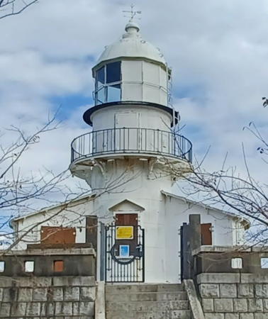


Seki Saki Light, Ōita City, November 2021
Google Maps photo by Daisuke Komori
Ōita City: Ōita Harbor Lighthouses
Ōita, a city of about half a million residents, is a major port and the capital of Ōita Prefecture. The port area has several basins spread along the south coast of Beppu Bay.
Ōita Kō West Breakwater
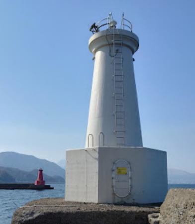
Date unknown. Active; focal plane 18 m (59 ft); continuous red light with a more intense flash every 3 s. 10 m (33 ft) round strongly conical concrete tower with lantern and gallery. Entire lighthouse painted red. A photo is at right, Trabas has a photo, FOAL's page for the two breakwater lights has photos, Lighthouse Visit has photos (last lighthouse on the page), a 2023 closeup and additional photos are available, and Google has a street view and a satellite view. These two breakwater lighthouses have a unique design. Located at the end of the west breakwater of a newer harbor at Otozu, on the west side of Ōita, the prefectural capital. Site status unknown. ARLHS JPN-2324; JCG-4995; Admiralty M4951; NGA 9392.
* Ōita Kō East Breakwater
Date unknown. Active; focal plane 18 m (59 ft); green flash every 3 s. 10 m (33 ft) round strongly conical concrete tower with lantern and gallery. Entire lighthouse is white. A photo is at right, Trabas has a photo, FOAL's page for the two breakwater lights has photos, Lighthouse Visit has photos (third lighthouse on the page), additional photos are available, and Google has a street view and a satellite view. Located at the end of the east breakwater of a newer harbor at Otozu, on the west side of Ōita, the prefectural capital. Site and tower closed. JCG-4994; Admiralty M4950; NGA 9388.
Sumiyoshi Kō West Breakwater
Date unknown. Active; focal plane 13 m (43 ft); two red flashes every 6 s. 9.5 m (31 ft) concrete post attached to a square 1-story concrete equipment room. Entire lighthouse is red. Trabas has a photo, FOAL's page for the breakwater lights has a photo, Lighthouse Visit has photos (second lighthouse on the page), and Google has a satellite view. Located at the end of the west breakwater of Sumiyoshi harbor in Ōita. Accessible only by boat. Site open, tower closed. ARLHS JPN-2334; JCG-4993; Admiralty M4948.6; NGA 9384.
Sumiyoshi Kō East Breakwater
Date unknown. Active; focal plane 14 m (46 ft); two green flashes every 6 s. 9.5 m (31 ft) concrete post attached to a square 1-story concrete equipment room. Entire lighthouse is white. Trabas has a photo, FOAL's page for the breakwater lights has a photo, Lighthouse Visit has photos (first lighthouse on the page), and Google has a street view and a satellite view. Located at the end of the short east breakwater of Sumiyoshi harbor in Ōita. Accessible by walking the pier. Site open, tower closed. ARLHS JPN-2333; JCG-4992; Admiralty M4948.4; NGA 9380.

West (left) and East Breakwater Lights, Ōita Kō, March 2023
Google Maps photo by Quappi S.
Otozu Kō West Breakwater
Date unknown. Active; focal plane 18 m (59 ft); red flash every 3 s. 16 m (52 ft) round cylindrical concrete tower with lantern and gallery. Entire lighthouse is red. Trabas has a photo, FOAL's page for the two breakwater lights has photos, and Google has a satellite view. Located at the end of the west breakwater of the industrial Otozu harbor in eastern Ōita. Accessible only by boat. Site and tower closed. ARLHS JPN-2326; JCG-4988; Admiralty M4947.7; NGA 9364.
Otozu Kō East Breakwater
Date unknown. Active; focal plane 18 m (59 ft); red flash every 3 s. 15 m (49 ft) round cylindrical concrete tower with lantern and gallery. Entire lighthouse is white. Trabas has a photo, FOAL's page for the two breakwater lights has photos, a distant 2023 view is available, and Bing has a satellite view. Located at the end of the east breakwater of the Otozu harbor. Accessible only by boat. Site and tower closed. JCG-4987; Admiralty M4947.74; NGA 9360.
Tsurasaki (Misa) Kō West Breakwater
Date unknown. Active; focal plane 13 m (43 ft); two red flashes every 6 s. 8.5 m (28 ft) concrete post attached to a square 1-story concrete equipment room. Entire lighthouse is red. Trabas has a photo and Google has a satellite view. Located at the end of the west breakwater of the Tsurasaki petroleum harbor in Ōita. Site and tower closed. ARLHS JPN-2320; JCG-4985; Admiralty M4947.5; NGA 9352.
Tsurasaki (Misa) Kō East Breakwater
Date unknown. Active; focal plane 13 m (43 ft); two green flashes every 6 s. 8.5 m (28 ft) round concrete tower with a flared top, attached to a small 1-story concrete equipment room. Entire lighthouse is white. Trabas has a photo and Google has a satellite view. Located at the end of the east breakwater of Tsurasaki petroleum harbor in Ōita. Site and tower closed. JCG-4984; Admiralty M4947.4; NGA 9348.
Ōzai Kō West Breakwater (?)
Date unknown. Apparently removed; listed with focal plane 12 m (39 ft); two red flashes every 6 s. 9 m (29 ft) concrete post attached to a square 1-story concrete equipment room. Entire lighthouse is red. Trabas has a photo but the light is not seen in a May 2023 photo or in Google's fuzzy satellite view. Located at the east end of a detached breakwater on the east side of Ōita. Accessible only by boat. Site open, tower closed. JCG-4982.81; Admiralty M4947.19; NGA 9341.
Ōzai Kō East Breakwater
Date unknown. Active; focal plane 13 m (43 ft); two green flashes every 6 s. 10 m (33 ft) round concrete tower, flared at the top and attached to a small equipment shelter. Entire lighthouse is white. Kenichiro Asai has a 2023 closeup photo and Trabas has a photo, but somehow the light is not seen in Google's fuzzy satellite view. Located at the west end of a detached breakwater on the east side of Ōita. Accessible only by boat. Site open, tower closed. JCG-4982.8; Admiralty M4947.18; NGA 9340.
Ōita Northeast Breakwater
Date unknown. Active; focal plane 12 m (39 ft); two red flashes every 6 s. 8.5 m (28 ft) round concrete tower with a flared top, attached to a small 1-story concrete equipment room. Entire lighthouse is red. Trabas has a good photo, FOAL has additional photos, and Google has a satellite view. Located at the end of a detached breakwater at the northeast end of the Ōita waterfront. Accessible only by boat. Site open, tower closed. JCG-4982.6; Admiralty M4947.09; NGA 9338.
Hiyoshibaru Anchorage East Breakwater
Date unknown. Active; focal plane 18 m (59 ft); green light, 3 s on, 3 s off. 19 m (62 ft) round cylindrical concrete tower with lantern and gallery; the lantern carries a traditional tall "dunce cap" roof. Entire lighthouse is white. Kenichiro Asai's 2022 photo is at right, Trabas has a photo, another page for the lighthouse has photos, FOAL has additional photos, and Google has a satellite view. Located on a detached breakwater at the end of the easternmost harbor of the Ōita metropolitan area. Accessible only by boat. Site and tower closed. ARLHS JPN-2309; JCG-4982.5; Admiralty M4947.08; NGA 9322.

Hiyoshibaru Anchorage East Breakwater Light, Ōita, December 2022
Google Maps photo by Kenichiro Asai

Ōita City: Saganoseki Area Lighthouses
* Saganoseki Kō Northern Harbor West Breakwater
1970. Active; focal plane 11 m (36 ft); red flash every 3 s. 8.5 m (28 ft) concrete post attached to a square 1-story concrete equipment room. Entire lighthouse is red. Trabas has a closeup photo, FOAL's page for the lighthouse has photos, Lighthouse Visit has photos (last lighthouse on the page), a 2023 closeup is available, and Google has a street view and a satellite view. Located at the end of a short breakwater at Saganoseki's northern harbor, on the north side of the Saganoseki peninsula. Accessible by walking the pier. ARLHS JPN-2329; JCG-4981; Admiralty M4946.6; NGA 9320.
 
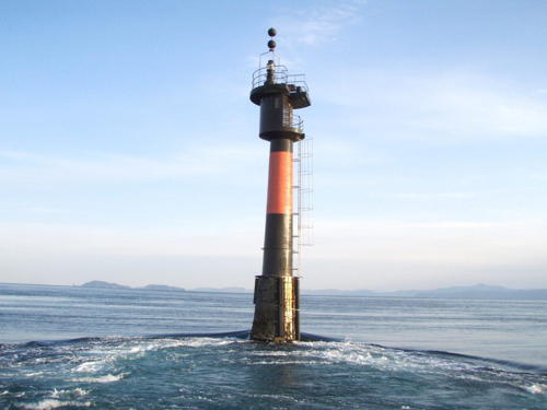
Bungo Hira Se
Date unknown. Active; focal plane 13 m (43 ft); two white flashes every 5 s. 12 m (39 ft) round cylindrical concrete tower with gallery, mounted on a concrete pier. Lighthouse painted black with one red horizontal band. A photo is at right, Trabas has a photo, FOAL's page for the Seki Saki lighthouse has a photo (halfway down the page), and Google has a satellite view. The lighthouse was rebuilt in 1990 and the photo at right is from the contractor's web site. Located about 1.5 km (1 mi) northeast of the Seki Saki lighthouse (next entry). Accessible only by boat, but visible from shore. Site open, tower closed. JCG-4977; Admiralty M4947; NGA 9300.
*** Seki Saki
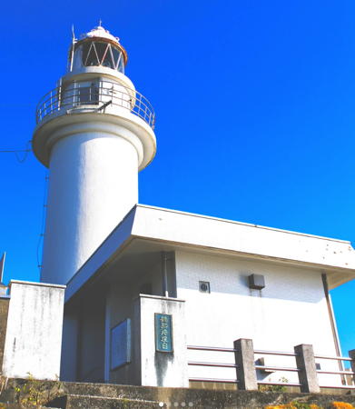
1901. Active; focal plane 69 m (226 ft); white light, 4 s on, 4 s off. 10 m (33 ft) round cylindrical cast iron tower with lantern and gallery, rising from a circular 1-story cast iron keeper's house. Entire lighthouse painted white. 1st order Chance Brothers Fresnel lens (1870, installed here in 1918). Daisuke Komori's photo is at the top of this page, Lighthouse-Japan.com has a page with several good photos, FOAL's page has excellent photos, the Ōita Coast Guard Office has a page for the lighthouse, Wikimedia has photos, additional photos are available, Lighthouse Visit also has photos, Trabas has an drone view, and Google has a satellite view and a closeup street view. The keeper's house is circular in form, but it only covers 2/3 of the circle. This lighthouse repeats in iron a common design used for stone lighthouses throughout the Seto Inland Sea. It marks the northern entrance to the Bungo Strait (Bungo-suidō), a strait separating the islands of Kyūshū and Shikoku. At the northern end of the strait there is a relatively narrow passage called the Hōyo Strait, about 17 km (11 mi) wide, between the outstretched "fingers" of Seki Saki on Kyūshū and Sada Misaki on Shikoku. Located on the point of the cape; in fair weather it is possible to see the Sada Misaki Light on Shikoku. Accessible by road and a short walk; at the end of the road is a visitor center called the Sea Star Pavilion (Kaiseikan). Site open, tower closed. . ARLHS JPN-550; JCG-4979; Admiralty M4946; NGA 9308.

Bungo Hira Se Light, Saganoseki
photo posted by Ando Kensetsu
Ashike (Asike) Bae
Date unknown. Active; focal plane 21 m (69 ft); white flash every 3 s. 15 m (49 ft) round tapered concrete tower with gallery. Entire lighthouse is white. Gen Kawanami's photo is at right, S. Katsuragi has a 2023 view from the sea, Trabas has a distant view, another very distant view is available and Google has a satellite view. Located on a skerry off the eastern point of Taka Shima about 3.2 km (2 mi) east of Seki Saki. Accessible only by boat. Site status unknown. JCG-4978; Admiralty M4947.04; NGA 9304.
* Saganoseki Gyoko
1986. Active; focal plane 13 m (43 ft); red light, 2 s on, 2 s off. 10 m (33 ft) concrete post attached to a square 1-story concrete equipment room. Entire lighthouse is red. Trabas has a closeup photo, additional photos are available, FOAL's March 2012 photo shows the light under restoration, and Google has a satellite view showing a recent extension of the breakwater. Located at the end of the outer breakwater of a harbor about 1 km (0.6 mi) south of Saganoseki. Accessible by walking the pier. Site open, tower closed. ARLHS JPN-2327; JCG-4979.5; Admiralty M4945; NGA 9312.
* Saganoseki Kō East Breakwater
1963. Active (?); focal plane 11 m (36 ft); continuous red light with a more intense flash every 6 s. 8.5 m (28 ft) concrete post attached to a square 1-story concrete equipment room. Entire lighthouse is red. FOAL has another page for the light, additional photos are available, Trabas has a closeup photo, a 2023 photo is available, and Google has a satellite view. This light has been removed from the Admiralty list; it is likely it has been supplanted by the Saganoseki Gyoko light (previous entry) but it remains on FOAL's list of active lights. Saganoseki is a former fishing port, now mostly a harbor for recreational craft, in the lee of Seki Saki. Located at the end of the east breakwater of Saganoseki. Accessible by walking the pier. Site open, tower closed. ARLHS JPN-2328; JCG-4980; ex-Admiralty M4944; NGA 9316.

Ashike Bae Light, Bungo Strait, Jaunary 2020
Google Maps photo by Gen Kawanami

Usuki City Lighthouses
Shitanoe (Shimonoe)
1951. Active; focal plane 21 m (69 ft); white light, 6 s on, 2 s off. 8.5 m (28 ft) concrete post attached to a square 1-story concrete equipment room. Entire lighthouse is white. FOAL's page for the lighthouse has several photos, Lighthouse Visit also has a page with photos, additional photos are available, Trabas has a view, and Google has a satellite view. Located on a long promontory sheltering the east side of the harbor of Shitanoe. Site appears open, tower closed. ARLHS JPN-2332; JCG-5729; Admiralty M4943; NGA 10568.
Usuki Kō North Breakwater
Date unknown. Active; focal plane 8 m (26 ft); red flash every 3 s. 7 m (23 ft) tripod mounted on a round 1-story concrete equipment shelter. Entire lighthouse is red. FOAL's page for the breakwater lights has a photo, the Lighthouse Visit page has photos, Trabas has a photo, and Google has a satellite view and a street view across the harbor. Located at the end of the detached north breakwater at Usuki. Accessible only by boat. Site open, tower closed. JCG-5728; Admiralty M4940; NGA 10560.
Usuki Kō
Date unknown (station established 1939). Active; focal plane 12 m (39 ft); white light, 6 s on, 2 s off. 9.5 m (31 ft) concrete post attached to a square 1-story concrete equipment room. Entire lighthouse is white. Trabas has a photo, FOAL's page for the breakwater lights has a photo, the Lighthouse Visit page has photos, additional photos are available, and Google has a satellite view and a street view across the harbor. Located at the end of the main breakwater at Usuki. Accessible only by boat. Site open, tower closed. JCG-5727; Admiralty M4941; NGA 10564.

Tsukumi City Lighthouses
Kusuva Saki (Tomariganti)
Date unknown. Active; focal plane 73 m (240 ft); white flash every 4 s. 10 m (33 ft) round cylindrical tower. Entire lighthouse is white. A closeup photo (halfway down the page, dated 2011/3/5) is available and Google has a distant satellite view. This lighthouse is in a very remote area. Located at the end of a long promontory extending into Bungo Strait between Usuki and Tsukumi. Site open, tower closed. ARLHS JPN-2338; JCG-5725; Admiralty M4938.3; NGA 10556.
Tsukumi Kō Detached Breakwater
Date unknown. Active; focal plane 12 m (39 ft); green flash every 3 s. 9 m (30 ft) concrete post attached to a square 1-story concrete equipment room. Entire lighthouse is white (NGA lists it incorrectly as being green). Trabas has a closeup photo, FOAL's page for the light has photos, and Google has a satellite view. Located on a breakwater in Tsukumi harbor. Accessible only by boat. Site status unknown. ARLHS JPN-2340; JCG-5723; Admiralty M4930; NGA 10548.
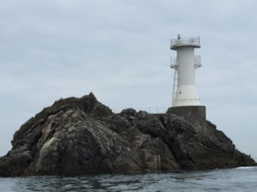
Chinu Saki
Date unknown. Active; focal plane 11 m (36 ft); green light, 2 s on, 2 s off. 8.5 m (28 ft) round concrete tower flared at the top. Entire lighthouse is white. A photo is at right, FOAL has a photo, Trabas has a photo, and Google has a satellite view. Located at the end of a breakwater off the Chinu Saki promontory, on the south side of the entrance to Tsukumi Bay. Accessible only by boat. Site open, tower closed. JCG-5721; Admiralty M4929; NGA 10552.
Tsukumi Shiraishi (Tsukumi Sirais)
Date unknown. Active; focal plane 12 m (39 ft); two white flashes every 5 s. 9 m (30 ft) round concrete tower, painted black with one red horizontal band. Trabas has a closeup photo and Bing has an indistinct satellite view. Located on a rocky reef off a promontory about 10 km (6 mi) east northeast of Tsukumi. Accessible only by boat. Site open, tower closed. JCG-5719; Admiralty M4928; NGA 10536.
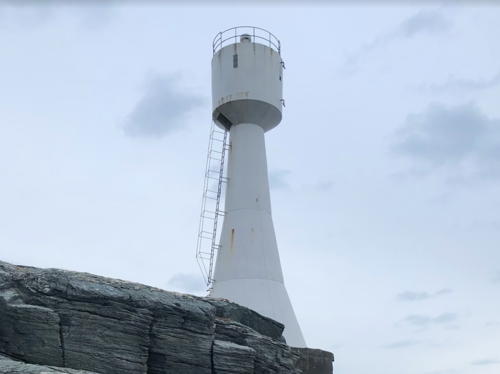
Takago Iwa
Date unknown. Active; focal plane 19 m (62 ft); white flash every 3 s. 8.5 m (28 ft) round white concrete tower. A photo is at right, Trabas has a photo, a view from the sea is available, Lighthouse Visit has a page for the lighthouse, and Google has a satellite view. Located at the end of a long reef extending into Bungo Strait off Hotojima. Accessible only by boat. Site open, tower closed. JCG-5716; Admiralty M4922; NGA 10524.

Takago Iwa Light, Tsukumi, June 2015
Google Maps photo by Haru-chan

Saiki City Lighthouses
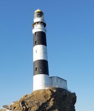
Mizunoko Shima
1904. Active; focal plane 56 m (184 ft); white flash every 10 s. 39 m (128 ft) round stone tower with lantern and gallery, attached to a 2-story stone keeper's house. Lighthouse painted with black and white horizontal bands. A photo is at right, the Ōita Coast Guard Office has a page for the lighthouse, Lighthouse-Japan.com has a page with excellent closeup photos, Wikimedia has a photo, FOAL's page has distant views (halfway down the page), Trabas has a distant view, and Google has a satellite view. The lighthouse was repaired after being heavily damaged during World War II. The onshore keeper's station at Tsurumi Saki (see below), used until 1962, is now incorporated into the Bungo Strait Maritime Museum; Nobuhiro Yamashita has a photo and Google has a satellite view. This is one of Japan's tallest lighthouses. Located on an isolated rock in the center of the Bungo Strait about 25 km (15 mi) east northeast of Saiki. Accessible only by boat. Site and tower closed. ARLHS JPN-369; JCG-5701; Admiralty M4912; NGA 10464.
Motoga Hana
Date unknown. Active; focal plane unknown; continuous white light. Approx. 8 m (26 ft) square concrete tower with lantern room and gallery; the light is shown through a square window and illuminates a nearby reef. A closeup photo (1/4 the way down the page, search for "5710") is available, and Google has a satellite view. Located on the eastern tip of Onyu Shima, an island just off the coast on the north side of Saiki harbor. The FOAL webmaster was able to find the light in a steep mountain forest; local guidance will be needed. Site open, tower closed. JCG-5710; Admiralty M4918.5.
* Todo Hana (Saiki)
Date unknown. Active; focal plane 23 m (75 ft); white light occulting once every 8 s. 10 m (33 ft) concrete post attached to a square 1-story concrete equipment room. Entire lighthouse is white. FOAL's page for Saiki lighthouses has views (halfway down the page), a closeup photo (1/4 the way down the page, search for "5711") is available, Trabas has a photo, Kenichiro Asai has a 2023 view from the sea, and Google has a satellite view. This lighthouse guides vessels into the port of Saiki. Located at the southern point of Onyu Shima. The island is accessible by passenger ferry and it's only a short walk to the lighthouse; also there should be at least a distant view from ferries crossing Bungo Strait between Saiki and Sukomo, Shikoku. Site open, tower closed. ARLHS JPN-2337; JCG-5711; Admiralty M4918; NGA 10580.

Mizunoko Shima Light, Bungo Strait, March 2019
Google Maps photo by Naisu Anai
Saiki Kō Detached Breakwater West Head
Date unknown. Active; focal plane 11 m (36 ft); two green flashes every 7 s. 8.5 m (28 ft) concrete post attached to a square 1-story concrete equipment room. Entire lighthouse is white. Trabas has a closeup photo, FOAL's page for Saiki lighthouses has two photos (fifth and next to last rows), a 2022 photo is available, and Google has a satellite view and a distant street view. Located at the east end of a detached breakwater in Saiki harbor. Accessible only by boat. Site open, tower closed. JCG-5713; Admiralty M4920.2; NGA 10588.
Saiki Kō Detached Breakwater East Head
Date unknown. Active; focal plane 11 m (36 ft); two red flashes every 7 s. 8.5 m (28 ft) concrete post attached to a square 1-story concrete equipment room. Entire lighthouse is red. Trabas has a closeup photo, FOAL's page for Saiki lighthouses has two photos (second and third rows), a 2022 photo is available, and Google has a satellite view and a distant street view. Located at the east end of a detached breakwater in Saiki harbor. Accessible only by boat. Site open, tower closed. JCG-5712; Admiralty M4920.4; NGA 10584.
Takega Shima
Date unknown. Active; focal plane 38 m (125 ft); white flash every 5 s. 7 m (23 ft) concrete post attached to a square 1-story concrete equipment room. Entire lighthouse is white. Kajikawa Osamu has a view from the sea, there is a somewhat closer view (1/5 the way down the page, search for "5706"), and Google has a distant satellite view. Located on an isolated island in Saiki Bay about 5 km (3 mi) east of Todo Hana. Accessible only by boat. Site status unknown. ARLHS JPN-2335; JCG-5706; Admiralty M4916; NGA 10572.
Motonoma Kaikyō (Motonoma Strait)
Date unknown. Active; focal plane 12 m (39 ft); two white flashes every 5 s. 12 m (39 ft) concrete post attached to a round 1-story concrete equipment room, mounted on a concrete pier. Lighthouse painted black with one red horizontal band. Trabas has a closeup photo, FOAL has a photo (last photo on the page), S. Katsuragi has a 2021 photo, and Google has a satellite view. Located on a reef in the narrow and dangerous Motonoma Strait between the mainland and the island of Sakai Oshima. Accessible only by boat. Site open, tower closed. JCG-5704; Admiralty M4910; NGA 10604.
Sakino Se
1961. Active; focal plane 43 m (141 ft); white flash every 4 s. 7.5 m (25 ft) round strongly conical concrete tower with gallery. Entire lighthouse is white. Trabas has a photo, Chie Ikeda has a view from the sea, FOAL's page has photos (2/3 the way down the page), and Google has a satellite view. Located on the highest of a group of three islets about 2 km (1.25 mi) east of Sakai Oshima. Accessible only by boat, and landing on the island is quite hazardous. Site and tower closed. JCG-5702; Admiralty M4913; NGA 10600.
*** Tsurumi (Turumi) Saki
1981. Active; focal plane 197 m (646 ft); white flash every 8 s. 14.5 m (48 ft) round cylindrical concrete tower with lantern and gallery. Entire lighthouse is white. A lighthouse museum has been built adjacent to the lighthouse. Yukihiro Matsumura's photo is at right, Lighthouse-Japan.com has a page with many photos, FOAL's page has good photos, a good closeup photo and additional photos of the lighthouse are available, Trabas has a photo, the Ōita Coast Guard Office has a page for the lighthouse, and Google has a street view and an indistinct satellite view. Tsurumi Saki is the tip of a long, ragged peninsula pointing due east into Bungo Strait; the cape is the easternmost point of the Kyūshū mainland. A good photo of the site is also available. On a clear day the mountains of Shikoku, 35 km (22 mi) to the east, can be seen from the lighthouse. Located about 20 km (13 mi) east of Saiki. Accessible by a twisting mountain road and a short hike; parking provided. Site open, museum open daily, tower status unknown but probably open. . ARLHS JPN-141; JCG-5703; Admiralty M4909.8; NGA 10608.

Tsurumi Saki Light, Saiki, December 2023
Instagram photo by Yukihiro Matsumura
Matsukiri Hana (Yonozu Hakuti)
1974. Active; focal plane 17 m (56 ft); white flash every 4 s. 9.5 m (31 ft) concrete post attached to a square 1-story concrete equipment room. Entire lighthouse is white. Additional photos are available, FOAL's page has closeup photos, Trabas has a photo, S. Katsuragi has a 2021 photo, and Google has a satellite view. Located at the tip of a sharp promontory at the entrance to the harbor of Iromiyo. It's a rough scramble to reach the lighthouse. Site open, tower closed. ARLHS JPN-2341; JCG-6788; Admiralty M4909.1; NGA 10610.
Okikuro (Oki Kuro) Shima
Date unknown. Active; focal plane 80 m (262 ft); white flash every 3 s. 9 m (30 ft) round concrete tower. FOAL's page has a distant view, Kenichiro Asai has a very distant 2023 view, and Google has a satellite view. Located at the eastern end of an island about 13 km (8 mi) southwest of Tsurumi Saki. Accessible only by boat. Site status unknown. ARLHS JPN-2325; JCG-6787; Admiralty M4909; NGA 10620.
* Kamae Kō
1951. Active; focal plane 13 m (43 ft); white flash every 5 s. 10 m (33 ft) round concrete tower rising from a 1-story concrete equipment room. Entire lighthouse is white. FOAL's page for Kamae lighthouses has photos, Lighthouse Visit has photos (second light on the page), Trabas has a photo, a 2021 photo and additional photos are available, and Google has a satellite view. Located on a promontory on the east side of the harbor of Kamae. Site status unknown. ARLHS JPN-2314; JCG-6785; Admiralty M4908; NGA 10624.
* #Kamae Kō Breakwater (1)
1976. Replaced around 2010. This was a 9.5 m (31 ft) round concrete tower rising from a 1-story concrete equipment room, but a more recent photo shows that the light (focal plane 12 m (39 ft); continuous red light with a more intense flash every 3 s) is now on a simple fiberglass post. Entire lighthouse is red. Trabas also has a photo of the new light and Google has a distant satellite view. Located at the end of the main breakwater of Kamae. Accessible by walking the pier. Site status unknown. ARLHS JPN-2315. Active light: JCG-6784; Admiralty M4908.4; NGA 10628.
* Maruichibi (Maruitibi) Kō
Date unknown. Active; focal plane 14 m (46 ft); continuous green light with a more intense flash every 6 s. 8.5 m (28 ft) concrete post attached to a square 1-story concrete equipment room. Entire lighthouse is white. FOAL has another page for the lighthouse, Trabas has a photo, a 2023 closeup is available, and Google has a satellite view and a distant street view. Located at the end of the breakwater at Mariuchibi. Accessible by walking the pier. Site open, tower closed. ARLHS JPN-2319; JCG-6782; Admiralty M4907; NGA 10636.
Huka Shima (Fuka Shima, Huka Se)
Date unknown. Active; focal plane 89 m (292 ft); white flash every 5 s. 10 m (33 ft) three-stage tower: a round cylindrical tower about a square "watch" room atop a larger square equipment room. Entire lighthouse is white. A photo is at right, Shinji Tanaka has a closeup photo, Trabas has a distant view, and Google has a very distant satellite view. Huka Shima is an island about 1.6 km (1 mi) long and 800 m (1/2 mi) wide, located a short distance off the coast of Kyūshū at the western entrance to the Bungo Strait. The island is the southernmost land in Ōita Prefecture. Located on the heights at the southern end of the island. Site status unknown. JCG-6781; Admiralty M4906; NGA 10632.

Huka Shima Light, Saiki, May 2023
Google Maps photo by SANMO X

Information available on lost lighthouses:

Notable faux lighthouses:

Adjoining pages: North: Northern Ōita | East: Western Ehime | South: Miyazaki

Return to the Lighthouse Directory index | Ratings key

Posted June 25, 2007. Checked and revised March 18, 2024. Lighthouses: 42. Site copyright 2024 Russ Rowlett and the University of North Carolina at Chapel Hill.