Lighthouses of South Korea: Donghae and Samcheok (Southern Gangwon)

For many centuries Korea was an independent kingdom or at least an autonomous kingdom under Chinese influence. This came to an end in 1910 when Japan annexed all of Korea. At the end of World War II in 1945 the 38° parallel was established as the dividing line between U.S. and Soviet zones of occupation, and in 1948 separate civil administrations were established in the two halves of the country. The Korean War (1950-53) ended in a draw with the armistice line falling close to the prewar 38° line. The Republic of Korea (ROK), commonly called South Korea, occupies the Korean peninsula south of the armistice line.

South Korea is divided into nine provinces and eight province-level cities. This page covers lighthouses of the central part of South Korea's east coast in the province of Gangwon (Gangwon-do), including the county-level cities of Donghae and Samcheok. This coast faces the East Sea (commonly called the Sea of Japan in the West). Most of it is rugged and scenic but there are some sandy beaches between the headlands. Although there are some famous and historic lighthouses on this coast many of the more modern lights are not well known.

Navigational aids in the ROK are regulated by the Ministry of Oceans and Fisheries (MOF). Management of lighthouses in Gangwon is the responsibility of the Donghae Regional Office of Oceans and Fisheries, with branch offices in the ports of Mukho, Sokcho, and Samcheok. The Korean Hydrographic and Oceanographic Administration (KHOA) publishes notices to mariners.

In 2000 South Korea adopted a Revised Romanization System to replace systems formerly used in the West. In the Revised System, the word for a lighthouse is deungdae (등대); dan (formerly tan) is a cape, seom (som) or do (to) is an island, am or amseog is a rock, man is a bay, and hang is a harbor. Some place names may be more familiar to Westerners in the spellings of older systems.

The name Korea, used internationally, is a Western version of Goryeo or Koryŏ (고려), the name of a kingdom that unified the country in the tenth century. From 1392 to 1897 the kingdom was known instead as Joseon or Chosŏn (조선). Today South Koreans usually call their country Hanguk (한국, literally "one country") and the official name of the Republic of Korea is Daehan Minguk (대한민국).

ARLHS numbers are from the ARLHS World List of Lights. KR numbers, where available, are from the Korean light list. Admiralty numbers are from volume M of the Admiralty List of Lights & Fog Signals. U.S. NGA List numbers are from Publication 112.

General Sources
Donghae Regional Office - Navigation Aids Office
Information on major lighthouses of Gangwon Province.
Online List of Lights - Korea
Photos by various photographers posted by Alexander Trabas.
Navionics Charts
Navigation chart information for this area.
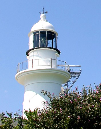
New Mukho Light
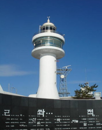
New Mukho Light, Donghae, December 2008
ex-Panoramio photo copyright 임보순; permission requested
Donghae (Tonghae) City Lighthouses

Donghae is a city of about 100,000 residents. It has two ports: the original Donghae harbor in the south and the newer Mukho harbor to the north. Historically Donghae shipped coal and iron ore from mines in the Taebaek Mountains behind the city; it is also an important fishing port, and Mukho is the terminal for ferries to the island of Ulleungdo in the East Sea.

Daejin Ward Lighthouses
* Donghaedaejin North Breakwater
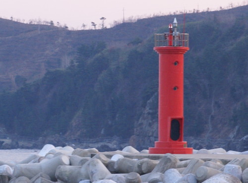
Date unknown. Active; focal plane 9 m (30 ft); two red flashes every 6 s. 6 m (20 ft) bulbous round concrete tower painted red. A 2020 photo showing both lighthouses is available and Google has a satellite view and a distant street view. Located on the north breakwater of Donghaedaejin harbor. Accessible by walking the pier. Site open, tower closed. KR-1243.5; Admiralty M4449.05; NGA 16455.
* Donghaedaejin South Breakwater
Date unknown. Active; focal plane 9 m (30 ft); two green flashes every 6 s. 6 m (20 ft) bulbous round concrete tower painted white. A 2020 photo showing both lighthouses is available and Google has a satellite view and a street view from the north breakwater. Located on the north breakwater of Donghaedaejin harbor. Accessible by walking the pier. Site open, tower closed. KR-1243.6; Admiralty M4449.06; NGA 16455.1.
* Daejin (Kanshin Tan, Hanjin)
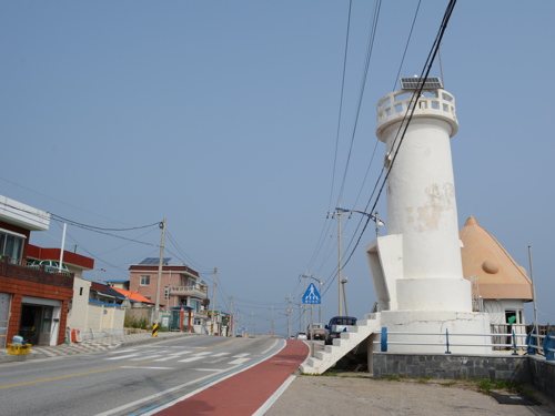
Date unknown. Active; focal plane 18 m (59 ft); white flash every 5 s. 10.5 m (34 ft) round white concrete tower. A closeup photo is at right, Y.J. Lee has a photo, and Google has a satellite view. Located beside the coastal highway about 3 km (2 mi) north of Mukho. Site open, tower closed. Admiralty M4449; NGA 16456.

Eodal Ward Lighthouses
Eodal
Date unknown. Active; focal plane 14 m (46 ft); red flash every 5 s. 14 m (46 ft) round red tower on what appears to be a round caisson. A photo is available and Google has a satellite view. Located on a shoal about 600 m (3/8 mi) north of the Eodal harbor. Accessible only by boat. Accessible by walking the pier. Site open, tower closed. KR-1243.7; Admiralty M4447.6; NGA 16460.
* Eodal North Breakwater
Date unknown. Active; focal plane 9 m (30 ft); red flash every 6 s. 6 m (20 ft) round cylindrical concrete tower with projections at the top suggesting outstretched arms. Entire lighthouse is red. Daesik Moon has a 2016 photo, Kim HeungKyu has a 2018 street view from the south breakwater, and Google has a satellite view. Located on the north (main) breakwater of Eodal harbor, on the north side of Mukho. Accessible by walking the pier. Site open, tower closed. KR-1245.5; Admiralty M4447.5; NGA 16463.

Daejin Light, Donghae, September 2014
ex-Panoramio photo by plumgarden; used by permission
* Eodal South Breakwater
Date unknown. Active; focal plane 9 m (30 ft); green flash every 6 s. 6 m (20 ft) round cylindrical concrete tower with projections at the top suggesting outstretched arms. Entire lighthouse is white. Kim HeungKyu has a closeup street view and Google has a satellite view. Located on the south breakwater of Eodal harbor, on the north side of Mukho. Accessible by walking the pier. Site open, tower closed. KR-1244.6; Admiralty M4447.51; NGA 16463.5.

Mukho Ward Lighthouses
#Mukho (1)
1963. Inactive since 2008 and replaced by a new lighthouse (next entry). This was a 12 m (39 ft) round concrete tower with lantern and gallery. Entire lighthouse was painted white. A photo is at right.
*** Mukho (2)
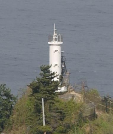
2008. Active; focal plane 88 m (289 ft); white flash every 10 s. 21 m (69 ft) round concrete tower with lantern and large round observation room. Entire lighthouse is white. Fog horn (blast every 55 s). A photo is at the top of this page, a good closeup and a 2022 photo are available, Richard Poth has a street view, and Google has a satellite view. This lighthouse, which serves as a landfall light for Mukho and Donghae, is a popular attraction because of its spectacular view of the East Sea. A lighthouse museum has been built next to the tower. Located on a headland that shelters the harbor of Mukho, on the north side of Donghae (Tonghae). Site open, museum open daily, tower probably open but no details are available. KR-1245; Admiralty M4447; NGA 16464.
* Mukho East Breakwater
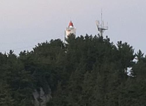
Date unknown. Active; focal plane 18 m (59 ft); red flash every 4 s. 11 m (36 ft) square pyramidal concrete tower supported by four legs. Entire lighthouse is red. A distant view (last photo on the page) is available, Stefano Lee Seungho has an overhead drone view, and Google has a satellite view. Located at the end of the main breakwater of Mukho harbor. Accessible by walking the pier. Site open, tower closed. Admiralty M4448.4; NGA 16467.
Mukho West Breakwater (Passenger Pier)
Date unknown. Active; focal plane 15 m (49 ft); green flash every 6 s. 11 m (36 ft) round cylindrical concrete tower, painted white. Stefano Lee Seungho has a drone view and Google has a satellite view. Located at the end of the passenger ferry pier in Mukho harbor. Accessible by walking the pier. Site open, tower closed. KR-1246; Admiralty M4448; NGA 16466.
Mukho South Groyne
Date unknown. Active; focal plane 14 m (46 ft); green flash every 4 s. 11 m (36 ft) round cylindrical concrete tower, painted white. Stefano Lee Seungho has a drone view and Google has a satellite view. Located at the end of the south groin, a breakwater about 350 m (0.2 mi) south of the older West Breakwater. Site status unknown. Admiralty M4448.5; NGA 16469.

Mukho Light
1963 Mukho Light, Donghae (replaced in 2008)
Donghae City photo


Donghae Harbor Lighthouses
Donghae (Bugpyeong Hang) North Breakwater (2?)
Date unknown. Active; focal plane 17 m (56 ft); red flash every 5 s. 15 m (49 ft) round red concrete tower. A distant photo of the two breakwater lights is available and Google has a satellite view. This light was replaced or at least relocated sometime in 2019-20 when the breakwater was shortened by about 350 m (1150 ft). Located at the end of the main breakwater of Donghae harbor. Site status unknown. KR-1250; Admiralty M4446.6; NGA 16480.
Donghae (Bugpyeong Hang) Detached Breakwater West Head
Date unknown. Active; focal plane 17 m (56 ft); four yellow flashes every 8 s. 10 m (33 ft) round yellow concrete tower. No photo available but Google has a satellite view. Located on a long detached breakwater protecting the harbor. Accessible only by boat. Site open, tower closed. KR-1248.2; Admiralty M4446.61.
Donghae (Bugpyeong Hang) Detached Breakwater East Head
Date unknown. Active; focal plane 27 m (89 ft); two red flashes every 6 s. 14 m (46 ft) round red concrete tower. No photo available and the lighthouse is not shown in Google's satellite view. Located on a long detached breakwater protecting the harbor. Accessible only by boat. Site open, tower closed. KR-1248.1; Admiralty M4446.62.
Donghae Jetty
Date unknown. Active; focal plane 9 m (30 ft); two green flashes every 5 s. 6 m (20 ft) round cylindrical white fiberglass tower. No photo available but Google has a satellite view. Located on a pier in Donghae harbor. Site and tower closed. KR-1248; Admiralty M4446.8; NGA 16478.
Donghae (Bugpyeong Hang) South Breakwater (2?)
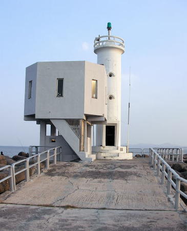
Date unknown. Active; focal plane 16 m (52 ft); green flash every 4 s. 11 m (36 ft) round cylindrical concrete tower, painted white. A closeup photo is at right, a distant photo of the two breakwater lights are available is available, and Google has a satellite view. This light was replaced or at least relocated sometime in 2019-20 when the breakwater was shortened by about 50 m (165 ft). Located at the end of the south breakwater of Donghae harbor. Site status unknown. KR-1251; Admiralty M4446.5; NGA 16484.
Donghae (Bugpyeong Hang) South Outer Breakwater North Head
2020. Active; focal plane 27 m (89 ft); two green flashes every 6 s. 14 m (46 ft) round white concrete tower. No photo available but Google has a satellite view. Located on an inner detached breakwater protecting the harbor. Accessible only by boat. Site open, tower closed. KR-1248.3; Admiralty M4446.625.


South Breakwater Light, Donghae
unattributed photo


Samcheok City Lighthouses

Samcheok is a city of about 70,000 residents. Unlike Donghae it has an expanded area including two coastal townships to the south. Wondeog, at the south end of the city, is an important liquified natural gas terminal.

Samcheok Harbor Lighthouses
* Samcheok Hang East Breakwater
Date unknown. Active; focal plane 16 m (52 ft); red flash every 4 s. 10 m (33 ft) round cylindrical concrete tower, painted red. A closeup of this light and a very distant view of both breakwater lights are available, S.D. Kim has a distant 2020 street view, and Google has a satellite view . Located at the end of the main breakwater of Samcheok harbor. Accessible by walking the pier. Site open, tower closed. Admiralty M4437; NGA 16492.
Samcheok Hang (Directional Light)
Date unknown. Active; focal plane 32 m (105 ft); continuous light, white, red or green depending on direction. 31 m (102 ft) steel skeletal tower with a square lantern enclosure. Byung Gook Choi has a 2018 photo and Google has a satellite view. This is a leading light guiding vessels into Samcheok harbor. Located on a wharf at Samcheok, a harbor about 4 km (2.5 mi) southeast of the Donghae harbor. Site status unknown. KR-1252; Admiralty M4437.2; NGA 16487.
Samcheok Hang West Breakwater
Date unknown. Active; focal plane 14 m (46 ft); green flash every 4 s. 10 m (33 ft) round cylindrical concrete tower, painted white. S.D. Kim has a distant 2020 street view and Google has a satellite view. Located at the end of the west breakwater of Samcheok harbor. Site status unknown. KR-1255; Admiralty M4436; NGA 16488.

Geundeog Township Lighthouses
Bimal (Pi Mal) (2)
2014 (station establishment date unknown). Active; focal plane 76 m (249 ft); white flash every 5 s. 15 m (49 ft) round white concrete tower. No closeup photo available. Alex Lee's 2017 distant view is at right and Google has an indistinct satellite view and a very distant street view. This is an important but poorly known and rarely visited lighthouse. The original light was on an 8 m (26 ft) round white concrete tower. (Note: Jon Clay discovered that a lighthouse fitting this description is on display at the Mokpo Children's Sea Science Musuem; Google has a street view.) Located on a promontory about 15 km (9 mi) southeast of Samcheok. Site status unknown. KR-1256; Admiralty M4435; NGA 16496.

Bimal Light, Samcheok, October 2017
Google Maps photo by Alex Lee

* Deoksan (Toksan) Hang East Breakwater
Date unknown. Active; focal plane 16 m (52 ft); red flash every 5 s. 10 m (33 ft) round cylindrical concrete tower, painted red. Jonan Sun has a closeup photo and Google has a satellite view and a street view showing both breakwater lighthouses. Located at the end of the main breakwater of Deoksan harbor, a small craft port sheltered by the cape of Bimal. Accessible by walking the pier. Site open, tower closed. Admiralty M4434.75; NGA 16505.
* Deoksan (Toksan) Hang West Breakwater
Date unknown. Active; focal plane 14 m (43 ft); green flash every 5 s. 11 m (36 ft) round cylindrical concrete tower, painted white. Lee Yun Won has a view across the harbor and Google has a satellite view and a street view showing both breakwater lighthouses. Located at the end of the west (really south) breakwater of Deoksan harbor, a small craft port sheltered by the cape of Bimal. Accessible by walking the pier. Site open, tower closed. Admiralty M4434.7; NGA 16506.
* Gungchon Hang East Breakwater
Date unknown. Active; focal plane 17 m (56 ft); red flash every 5 s. 14 m (46 ft) round concrete tower, strongly tapered from a conical base. Entire lighthouse is red. Lee Myung-ha has a 2021 street view, Cha Yeon-sook has a photo of both breakwater lighthouses, and Google has a satellite view. Located at the end of the main breakwater of Gungchon harbor. Accessible by walking the pier. Site open, tower closed. KR-1258.8; Admiralty M4434.53.
* Gungchon Hang South Breakwater
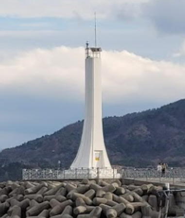
Date unknown. Active; focal plane 17 m (56 ft); green flash every 5 s. 14 m (46 ft) round concrete tower, strongly tapered from a conical base. Entire lighthouse is white. Cha Yeon-sook's photo is at right, Lee Myung-ha has a 2021 street view and Google has a satellite view. Located at the end of the inner breakwater of Gungchon harbor. Accessible by walking the pier. Site open, tower closed. KR-1258.7; Admiralty M4434.55.
* Chogok Hang (2)
2019. Active; focal plane 18 m (59 ft); green flash every 5 s. 9 m (30 ft) round white tower with lantern and gallery. Yoonho Aaron Kim has a view from shore and Google has a satellite view. NGA lists a 6 m (20 ft) square skeletal tower. Located on the breakwater at the small harbor of Chogok village about 8 km (5 mi) south of Samcheok. Accessible by walking the pier. Site open, tower closed. KR-1258.4; Admiralty M4434.5; NGA 16504.5.
* Jangho Hang Groyne
Date unknown. Active; focal plane 11 m (36 ft); red flash every 5 s. 10 m (33 ft) round cylindrical concrete tower, painted red. Jang Sub Lee has a distant view of both Jangho lighthouses, a drone view of the two breakwater lights is available, Matheus Gibertoni Trigo has a street view, and Google has an indistinct satellite view. Located at the end of the west breakwater of Jangho harbor, a small craft port about 25 km (15 mi) south of Samcheok. Accessible by walking the pier. Site open, tower closed. KR-1261; Admiralty M4434.3; NGA 16502.
* Jangho Hang Breakwater
Date unknown. Active; focal plane 17 m (56 ft); green flash every 5 s. 10 m (33 ft) round cylindrical concrete tower, painted white. Jang Sub Lee has a distant view of both Jangho lighthouses, a drone view of the two breakwater lights is available, Matheus Gibertoni Trigo has a street view, and Google has an indistinct satellite view. Located at the end of the main breakwater of Jangho harbor. Accessible by walking the pier. Site open, tower closed. KR-1260; Admiralty M4434.2; NGA 16504.
#Jangho
Date unknown. Inactive since 2014 and later demolished. This was a 7 m (23 ft) round white concrete tower. No photo available and the tower is not seen in Google's satellite view. Formerly located atop a promontory sheltering the harbor of Jangho. ex-Admiralty M4434; ex-NGA 16500.

Gungchon Hang South Breakwater Light, Samcheok, November 2020
Google Maps photo by Cha Yeon-sook


Wondeog Town Lighthouses
* Gallam Hang West Breakwater
Date unknown. Active; focal plane 16 m (52 ft); red flash every 4 s. 10 m (33 ft) round cylindrical concrete tower, painted red. Kaebi Choi has a photo of both lighthouses and Google has a satellite view. Located on the west breakwater of Gallam harbor. Accessible by walking the pier. Site open, tower closed. Admiralty M4433.99.
* Gallam Hang East Breakwater
Date unknown. Active; focal plane 16 m (52 ft); green flash every 4 s. 10 m (33 ft) round cylindrical concrete tower, painted white. Kaebi Choi has a photo of both lighthouses and Google has a satellite view. Located on the east breakwater of Gallam harbor. Accessible by walking the pier. Site open, tower closed. KR-1261.3; Admiralty M4433.98.
* Sin Nam Hang
Date unknown. Active; focal plane 14 m (46 ft); red flash every 5 s. 10 m (33 ft) round cylindrical concrete tower, painted red. A 2017 photo is available, Lee Jae-Gon has a more distant view, and Google has a satellite view. Located on the main breakwater of Sin Nam harbor. Accessible by walking the pier. Site open, tower closed. KR-1261.2; Admiralty M4433.95.
Imweon (Imwon) Hang
Date unknown. Active; focal plane 60 m (197 ft); white flash every 8 s. 10 m (33 ft) round cylindrical concrete tower, painted white. A photo is at right and Google has an indistinct satellite view. Located on a promontory about 32 km (20 mi) north of Uljin. Site and tower closed. Admiralty M4433.7; NGA 16508.
Imweon Hang East Breakwater
Date unknown. Active; focal plane 16 m (52 ft); red flash every 4 s. 10 m (33 ft) round cylindrical concrete tower, painted red. A 2018 photo is available, H.K. Lee has an aerial view of the harbor, and Google has a satellite view. Located at the end of the main breakwater of Imweon harbor. Site status unknown. KR-1264; Admiralty M4433.9; NGA 16518.
Imweon Hang West Breakwater
Date unknown. Active; focal plane 13 m (43 ft); green flash every 6 s. 10 m (33 ft) round cylindrical concrete tower, painted white. The light is near the center of a distant view, H.K. Lee has an aerial view of the harbor, and Google has a satellite view. Located at the end of the main breakwater of Imweon harbor. Site status unknown. KR-1263; Admiralty M4433.8; NGA 16516.

Imweon Hang Light, Samcheok, undated
Librewiki.net public domain photo by Chirho
Hosan North Breakwater
Date unknown. Active; focal plane 14 m (46 ft); red flash every 5 s. 10 m (33 ft) round cylindrical steel tower, painted red. Park Minseok's photo is at right and Google has a satellite view. Located at the end of the north breakwater of Hosan, a recreational harbor about 20 km (13 mi) north of Uljin. Site status unknown. KR-1264.1; Admiralty M4433.5; NGA 16551.
Hosan South Breakwater
Date unknown. Active; focal plane 14 m (46 ft); green flash every 5 s. 10 m (33 ft) round cylindrical steel tower, painted white. A 2017 photo is available and Google has a satellite view. Located at the end of the north breakwater of Hosan, a recreational harbor about 20 km (13 mi) north of Uljin. Site status unknown. KR-1264.2; Admiralty M4433.6; NGA 16551.1.
Hosan North Outer Breakwater South End
Date unknown. Active; focal plane about 30 m (98 ft), light characteristic unknown. Approx. 30 m (98 ft) round strongly tapered concrete tower. Entire lighthouse is yellow. No photo available but Google has a satellite view. This light and the next one frame a narrow entrance to the petroleum harbor at Hosan. Accessible only by boat. Site status unknown. Admiralty M4433.4.
Hosan South Outer Breakwater North End
Date unknown. Active; focal plane about 30 m (98 ft), light characteristic unknown. Approx. 30 m (98 ft) round strongly tapered concrete tower. Entire lighthouse is yellow. No photo available but Google has a satellite view. This light and the previous one frame a narrow entrance to the petroleum harbor at Hosan. Accessible only by boat. Site status unknown. Admiralty M4433.45.
Hosan North Training Dike
Date unknown. Active; focal plane about 18 m (59 ft); green light, pattern unknown. Approx.15 m (49 ft) white concrete towee. No photo available but Google has a satellite view. Located at the end of a short breakwater at the petroleum terminal. Site status unknown. Admiralty M4433.48.
Hosan North Breakwater Light
Hosan North Breakwater Light, February 2008
ex-Panoramio photo copyright Park Minseok; permission requested
Hosan South Training Dike
Date unknown. Active; focal plane about 30 m (98 ft), green light, pattern unknown. Approx. 30 m (98 ft) round strongly tapered concrete tower. Entire lighthouse is white. No photo available but Google has a satellite view and a distant street view of this light and the next one. This light and the next one frame the main entrance to the petroleum harbor at Hosan. Located at the end of a short breakwater at the petroleum terminal. Site status unknown. Admiralty M4433.37.
Hosan South Outer Breakwater South End
Date unknown. Active; focal plane 30 m (98 ft), red flash every 4 s. 30 m (98 ft) round strongly tapered concrete tower. Entire lighthouse is red. No photo available but Google has a satellite view and a distant street view of this light and the previous one. This light and the next one frame the main entrance to the petroleum harbor at Hosan. Accessible only by boat. Site status unknown. KR-1264.11; Admiralty M4433.35.
 

Information available on lost lighthouses:

Notable faux lighthouses:

Adjoining pages: North: Gangneung Area | South: Uljin Area

Return to the Lighthouse Directory index | Ratings key

Posted October 29, 2007. Checked and revised October 14, 2023. Lighthouses: 42. Site copyright 2023 Russ Rowlett and the University of North Carolina at Chapel Hill.