Lighthouses of South Korea: Uljin Area

For most of its history Korea was an independent kingdom or at least an autonomous kingdom under Chinese influence. This came to an end in 1910 when Japan annexed all of Korea. At the end of World War II in 1945 the 38° parallel was established as the dividing line between U.S. and Soviet zones of occupation, and in 1948 separate civil administrations were established in the two halves of the country. The Korean War (1950-53) ended in a draw with the armistice line falling close to the prewar 38° line. The Republic of Korea (ROK), commonly called South Korea, occupies the Korean peninsula south of the armistice line.

South Korea is divided into nine provinces and eight province-level cities. This page covers lighthouses of the northern half of North Gyeongsang Province (Gyeongsangbuk-do), including the counties of Uljin and Yeongdeok. This east coast of Korea faces the East Sea (commonly called the Sea of Japan in the West). Most of it is rugged and scenic but there are some sandy beaches between the headlands.

Navigational aids in the ROK are regulated by the Ministry of Oceans and Fisheries (MOF). Management of lighthouses in North Gyeongsang is the responsibility of the Pohang Regional Office of Oceans and Fisheries. The Korean Hydrographic and Oceanographic Administration (KHOA) publishes notices to mariners.

In 2000 South Korea adopted a Revised Romanization System to replace systems formerly used in the West. In the Revised System, the word for a lighthouse is deungdae (등대); dan (formerly tan) is a cape, seom (som) or do (to) is an island, am or amseog is a rock, man is a bay, and hang is a harbor. Some place names may be more familiar to Westerners in the spellings of older systems.

The name Korea, used internationally, is a Western version of Goryeo or Koryŏ (고려), the name of a kingdom that unified the country in the tenth century. From 1392 to 1897 the kingdom was known instead as Joseon or Chosŏn (조선). Today South Koreans usually call their country Hanguk (한국, literally "one country") and the official name of the Republic of Korea is Daehan Minguk (대한민국).

ARLHS numbers are from the ARLHS World List of Lights. KR numbers, where available, are from the Korean light list. Admiralty numbers are from volume M of the Admiralty List of Lights & Fog Signals. U.S. NGA List numbers are from Publication 112.
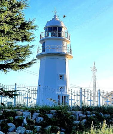

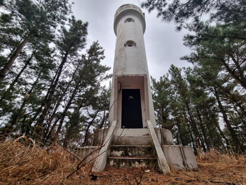
Hupo Light, Hupo, August 2022
Google Maps photo by Jongsik Lee
General Sources
Pohang Region Lighthouses
Information on major lighthouses posted by the Pohang MOF office.
Online List of Lights - Korea
Photos by various photographers posted by Alexander Trabas.
Navionics Charts
Navigation chart information for Korea.

Uljin County Lighthouses

Buk (North) Township Lighthouses
* Seoko Hang East Breakwater
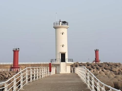
About 2021. Active; focal plane 11 m (36 ft); red flash every 6 s. 11 m (36 ft) round cylindrical red concrete tower with lantern and gallery. A distant photo of the two breakwater lights is available and Google has a satellite view. Located on the east (outer) breakwater of Seoko. Accessible by walking the pier. Site open, tower closed. KR-1266.3; Admiralty M4433.33.
* Seoko Hang West Breakwater
About 2021. Active; focal plane 11 m (36 ft); green flash every 6 s. 11 m (36 ft) round cylindrical white concrete tower with lantern and gallery. A distant photo of the two breakwater lights is available and Google has a satellite view. Located on the west (inner) breakwater of Seoko. Accessible by walking the pier. Site open, tower closed. KR-1266.2; Admiralty M4433.331.
Bugu (Hanul Nuclear Power Plant) North Breakwater
Date unknown. Active; focal plane 20 m (66 ft); red flash every 4 s. 15 m (49 ft) round cylindrical red concrete tower with lantern and gallery. No photo available but Google has a satellite view and a distant street view of the two breakwater lighthouses. The Hanul Nuclear Power Plant is the largest in South Korea and one of the largest in the world. Located on the north (outer) breakwater of the plant. Site and tower closed. Admiralty M4433.2.
Bugu (Hanul Nuclear Power Plant) South Breakwater
Date unknown. Active; focal plane 20 m (66 ft); green flash every 4 s. 16 m (52 ft) round cylindrical white concrete tower with lantern and gallery. No photo available but Google has a satellite view and a distant street view of the two breakwater lighthouses. Located on the south (inner) breakwater of the plant. Site and tower closed. Admiralty M4433.3.

Jukbyeon Township Lighthouses
* Jukbyeon (Chukpyong Dong)
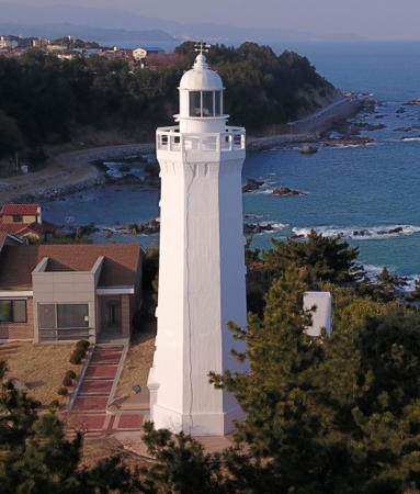
1910. Active; focal plane 49 m (161 ft); white flash every 20 s. 16 m (52 ft) octagonal concrete tower with lantern and gallery. Entire lighthouse is white. Fog horn (one blast every 50 s). A photo is at right, Kim Tae Yun has a photo, KiYoung Kim has a 2021 photo, a distant view shows the situation of the lighthouse, and Google has a satellite view and a distant street view. Although built by French engineers this historic lighthouse exhibits a typical Japanese design of the period. It was damaged during the Korean War in 1950 but was repaired and back in operation by late 1951. Located on a prominent cape about 8 km (5 mi) north of Uljin. Site open, tower closed. . KR-1279; Admiralty M4432; NGA 16552.
* Jukbyeon East Outer Breakwater
2018. Active; focal plane 17 m (56 ft); red flash every 4 s. 9 m (30 ft) round cylindrical red concrete tower. A photo is available, Minsu Lee has a very distant view from shore and Google has a satellite view and a distant street view. The Jukbyeon harbor was extended by building new outer breakwaters in 2017-18. Located at the end of the new breakwater. Accessible by walking the pier. Site open, tower closed. KR-1280.5; Admiralty M4432.3.
#Jukbyeon East Inner Breakwater (1)
Date unknown. Removed in 2017. This was an 8 m (26 ft) round cylindrical concrete tower, painted red. Photos of both breakwater lights are available. There is an active light (two red flashes every 6 s) on a short post; Google has a satellite view. Located at the end of the original east breakwater; accessible by walking the pier. Site open, tower closed. Active light: KR-1280; Admiralty M4432.6; NGA 16556.
#Jukbyeon West Inner Breakwater (1)
Date unknown. Removed around 2014. This was an 8 m (26 ft) round hourglass-shaped white concrete tower. Photos of both breakwater lights are available. The lighthouse has been removed; Google's satellite view confirms the removal. There is an active light (two green flashes every 6 s) on a small skeletal tower. Formerly located at the end of the original east breakwater. Site open, tower closed. Active light: Admiralty M4433; NGA 16560.
* Jukbyeon West Outer Breakwater
2018. Active; focal plane 16 m (52 ft); green flash every 4 s. 9 m (30 ft) round cylindrical white concrete tower. A 2019 photo is available and Google has a satellite view and a distant street view. The Jukbyeon harbor was extended by building new outer breakwaters in 2017-18. Located at the end of the new breakwater. Accessible by walking the pier. Site open, tower closed. Admiralty M4432.4.

Jukbyeon Light, Uljin, February 2020
Ministry of Oceans and Fisheries photo

Wonnam Township Lighthouses
* Jinmimal (Chinmi Mal)
1984. Active; focal plane 58 m (190 ft); white flash every 6 s. 12 m (39 ft) round white concrete tower. Google has a distant street view and a satellite view. Located at Jinmimal, a small fishing port about 8 km (5 mi) south of Uljin. Site open, tower closed. Admiralty M4431.5; NGA 16564.
* Osan North Breakwater
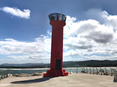
Date unknown. Active; focal plane 15 m (49 ft); red flash every 4 s. 8 m (26 ft) round cylindrical metal (?) tower, painted red. Wonwoo Lee has the closeup photo also seen at right. a 2021 photo is available, and Google has a satellite view and a distant street view. Located at the end of the breakwater; accessible by walking the pier. Site open, tower closed. KR-1283; Admiralty M4431.45; NGA 16565.
* Osan South Breakwater
Date unknown. Active; focal plane 15 m (49 ft); green flash every 4 s. 10 m (33 ft) round cylindrical concrete tower. Formerly painted all white, but in 2022 it was repainted white with three narrow green horizontal bands, as seen in Jinki Kim's photo. A 2021 photo is available, Wonwoo Lee has a photo showing both Osan lighthouses, and Google has a satellite view and a distant street view. Located at the end of the breakwater; accessible by walking the pier. Site open, tower closed. KR-1283.1; Admiralty M4431.48.

Giseong Township Lighthouses
* [Sadong North Breakwater (2)]
Date unknown. Active; focal plane 17 m (56 ft); red flash every 5 s. This was formerly a 10 m (33 ft) round cylindrical concrete tower, painted red; Google has a street view and a satellite view. It was replaced by a post light sometime in 2020-21; a 2023 photo is available. Located at the end of the north (main) breakwater of Sadong harbor; accessible by walking the pier. Site open, tower closed. Admiralty M4431.2; NGA 16566.
* Sadong South Breakwater
Date unknown. Active; focal plane 15 m (49 ft); green flash every 5 s. 10 m (33 ft) round cylindrical concrete tower, painted white. A 2023 closeup is available and Google has a street view and a satellite view. Located at the end of the south breakwater of Sadong harbor; accessible by walking the pier. Site open, tower closed. KR-1287; Admiralty M4431.4; NGA 16566.2.

Osan North Breakwater Light, Uljin, April 2015
Google Maps photo by Wonwoo Lee
Hwamomal
Date unknown. Active; focal plane 48 m (157 ft); white flash every 7 s. 10 m (33 ft) round white concrete tower. Choi Seung-gu's 2022 photo is at right and Google has a distant street view and a fuzzy satellite view. Located on a promontory about 35 km (22 mi) south of Uljin. Site status unknown. KR-1284; Admiralty M4431; NGA 16568.
* Gusan North Breakwater
Date unknown. Active; focal plane 15 m (49 ft); red flash every 5 s. 8 m (26 ft) round cylindrical concrete tower, painted red. Google has a distant street view and a satellite view. Located at the end of the north (main) breakwater of Gusan harbor; accessible by walking the pier. Site open, tower closed. KR-1285; Admiralty M4430.5; NGA 16569.
* Gusan South Breakwater
Date unknown. Active; focal plane 16 m (52 ft); green flash every 5 s. 10 m (33 ft) round cylindrical concrete tower, painted white. Google has a distant street view and a satellite view. Located at the end of the south breakwater of Gusan harbor; accessible by walking the pier. Site open, tower closed. KR-1285.1; Admiralty M4430.8; NGA 16569.1.

Pyeonghae Town Lighthouses
* Jiksan East Breakwater
Date unknown. Active; focal plane 14 m (43 ft); red flash every 4 s. 10 m (33 ft) round cylindrical concrete tower, painted red. A photo of this light and a photo of both breakwater lights are available and Google has a street view and a satellite view. Located at the end of the north (main) breakwater of Jiksan harbor; accessible by walking the pier. Site open, tower closed. KR-1287.5; Admiralty M4430.31; NGA 16569.9.
* Jiksan South Breakwater
Date unknown. Active; focal plane 14 m (43 ft); gteen flash every 4 s. 10 m (33 ft) round cylindrical concrete tower, painted white. A photo of both breakwater lights is available and Google has a street view and a satellite view. Located at the end of the south breakwater of Jiksan harbor; accessible by walking the pier. Site open, tower closed. KR-1287.4; Admiralty M4430.3; NGA 16569.7.

Hwamomal Light, Giseong, February 2022
Librewiki Creative Commons photo by Choi Seung-gu
Wangdalcho
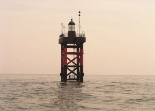
Date unknown. Active; focal plane 16 m (52 ft); two white flashes every 5 s. 30 m (98 ft) tower, with a lantern mounted on a square platform supported by four robust piles. Lighthouse painted black with a red horizontal band. The Hydrographic and Oceanic Administration's photo is at right but the light is not shown in Google's satellite view. The light marks a dangerous underwater ridge. Located on a shoal about 25 km (15 mi) east northeast of Hupo. KR-1282; Admiralty M4430.2; NGA 16571.

Hupo Township Lighthouses
* Jedong (Chedong) Hang
Date unknown. Active; focal plane 15 m (49 ft); red flash every 5 s. 10 m (33 ft) round cylindrical concrete tower, painted red. Google has a distant street view and an indistinct satellite view. Located on the north breakwater at Jedong, a small boat harbor on the north side of Hupo. Accessible by walking the pier. Site open, tower closed. Admiralty M4427; NGA 16574.
** Hupo
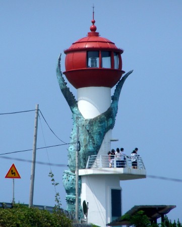
1968. Active; focal plane 64 m (210 ft); white flash every 10 s. 10 m (33 ft) octagonal concrete tower with lantern and gallery. Entire lighthouse is white. Fog siren (one blast every 60 s). 1-story keeper's house. Jongsik Lee has the 2022 photo seen at the top of this page, Kim Dong-il has a 2018 photo, a blogger has several photos, Heechang Han has a street view, and Google has a satellite view. An "observatory" next to the lighthouse provides a spectacular view of the coast and surrounding mountains. Located on a prominent cape sheltering the harbor of Hupo, about 40 km (25 mi) north of Yeongdeok. A nearby hot springs provides convenient parking. . KR-1289; Admiralty M4426; NGA 16572.
Wangdalcho Light
Wangdalcho Light, East Sea
Korea Hydrographic and Oceanographic Administration photo
#Hupo Hang East Breakwater
Date unknown. Removed sometime in 2020-21. This was a 10 m (33 ft) round cylindrical concrete tower, painted red with a white band at the bottom. Google has a satellite view and a very distant street view but a 2023 view of the harbor confirms the removal. Located at the end of the east (main) breakwater at Hupo. Accessible by walking the pier. Site open, tower closed. Admiralty M4430.04; NGA 16576.
* Hupo Hang West Breakwater
Date unknown. Active; focal plane 13 m (43 ft); green flash every 5 s. 10 m (33 ft) round cylindrical white concrete tower. A photo is available (second photo on the page) and Google has a street view and a satellite view. Located at the end of the west breakwater at Hupo. Accessible by walking the pier. Site open, tower closed. KR-1292; Admiralty M4430; NGA 16580.
* Hupo Marina Breakwater
Date unknown. Active; focal plane about 13 m (43 ft); green light, pattern unknown. Approx. 10 m (33 ft) round cylindrical white concrete tower. No photo available but Google has a satellite view. Located at the end of the yacht club breakwater, west of the West Brreakwater, at Hupo. Accessible by walking the pier. Site open, tower closed. Admiralty M4429.8.

Yeongdeok County Lighthouses

Byeonggok Township Lighthouses
[Baekseok Hang East Breakwater (2)]
Date unknown. Active; focal plane 14 m (46 ft); red flash every 5 s. 10 m (33 ft) post rising from a small equipment shelter. Google has a street view but the light is not seen clearly in Google's satellite view. Entire structure painted red. The original lighthouse was a round cylindrical concrete tower. Located at the end of the main breakwater of Baekseok, a beach resort at the northern edge of Yeongdeok. Site status unknown. Admiralty M4428.
Baekseok Hang West Breakwater
Date unknown. Active; focal plane 13 m (43 ft); green flash every 5 s. 10 m (33 ft) round cylindrical white concrete tower. Google has a street view and a satellite view. Located at the end of the west breakwater of Baekseok. Site status unknown. Admiralty M4428.1; NGA 16581.
* Byeonggok Hang
Date unknown. Active; focal plane 15 m (49 ft); red flash every 5 s. 10 m (33 ft) round cylindrical concrete tower, painted red. Google has the closeup street view seen at right and a satellite view. Located on the east breakwater at Byeonggok, a small boat harbor on the north side of Daejin. Accessible by walking the pier. Site open, tower closed. KR-1292.3; Admiralty M4424.8.

Yeonghae Township Lighthouses
* Daejin (Taejin) Hang North Breakwater
Date unknown. Active; focal plane 15 m (49 ft); red flash every 5 s. 8.5 m (28 ft) round cylindrical concrete tower, painted red. Google has a street view and a satellite view. Located at the end of the main breakwater of Daejin, a beach resort at the northern edge of Yeonghae. Accessible by walking the pier. Site open, tower closed. KR-1292.5; Admiralty M4424.5; NGA 16597.

Byeonggok Hang Light, Byeonggok, July 2018
Google Maps street view
* Daejin (Taejin) Hang South Breakwater
Date unknown. Active; focal plane 13 m (43 ft); green flash every 5 s. 10 m (33 ft) round cylindrical white concrete tower. Google has a distant street view and a satellite view. Located at the end of the south breakwater of Daejin. Accessible by walking the pier. Site open, tower closed. KR-1292.6; Admiralty M4424.6; NGA 16598.

Chuksan Township Lighthouses
* Chuksan Hang North Breakwater (3)
2020 (?). Active; focal plane about 18 m (59 ft); red flash every 5 s. Approx. 14 m (46 ft) round cylindrical concrete tower with lantern and gallery. Entire lighthouse is red. Hyo-sook Kwon has an August 2021 drone view. The original lighthouse was an 8 m (26 ft) octagonal cylindrical concrete tower, painted red. Google's 2015 street view shows that light replaced by a simple post when the breakwater was extended. Bing has a satellite view. The Admiralty dropped its listing of the light in 2019, probably when the post light was removed; it has added the new lighthouse with a new number. Located at Chuksan, a small fishing port about 12 km (7.5 mi) north of Yeongdeok. Accessible by walking the pier. Site open, tower closed. KR-1293; Admiralty M4421.2 (ex-M4421); NGA 16592.
#Chuksan Hang Inner Breakwater
Date unknown. Inactive since 2020 and later removed; listed by NGA with focal plane 10 m (33 ft); green flash every 5 s. 8 m (26 ft) round hourglass-shaped white concrete tower. Google has a 2015 street view and a satellite view but the light is no longer seen in Bing's satellite view. Located at the end of the inner south breakwater of Chuksan. Accessible by walking the pier. Site open, tower closed. ex-KR-1294; ex-Admiralty M4420; NGA 16588.
* Chuksan Hang South Breakwater (2)
2020. Active; focal plane 15 m (49 ft); green flash every 5 s. 8 m (26 ft) octagonal cylindrical white concrete tower. Google has a street view and a satellite view. NGA describes a smaller tower here. Located at the end of the outer south breakwater of Chuksan. Accessible by walking the pier. Site open, tower closed. KR-1294.5; Admiralty M4420.3; NGA 16594.
*** Chuksan (Jukdosan Observatory) (2)
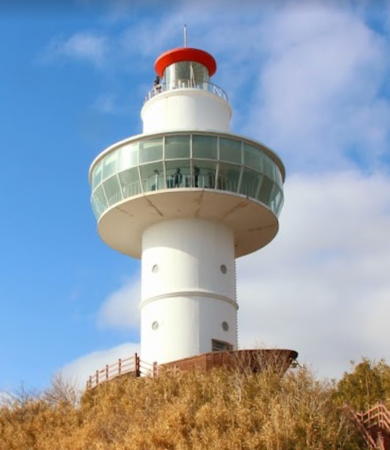
2011 (station established 1935). Active; focal plane 102 m (335 ft); white flash every 5 s. 23 m (75 ft) round concrete tower with lantern, gallery, and a large observation level. The lighthouse is white, lantern dome red. A 2021 photo is seen at right, Seonbo Lee has a photo, Chang Hyun Lim has a closeup photo, Google has a street view and a satellite view. The 1935 Japanese-built lighthouse, heavily damaged during World War II, was rebuilt after the war. Located on the heights south of Chuksan harbor. Site open (it's a stiff climb), and the observation level is open to visitors. On-street parking is available at the foot of the hill. KR-1295; Admiralty M4424; NGA 16584.

Chuksan Light, Chuksan, February 2021
Google Maps photo by heosu
* Gyeongjeong Hang East Breakwater
Date unknown. Active; focal plane 15 m (49 ft); red flash every 4 s. 10 m (33 ft) round cylindrical concrete tower, painted red. Jeong-Min Kim has a 2020 photo of both breakwater lights and Google has a street view and a satellite view. Located at the end of the main breakwater of Gyeongjeong harbor, about 2.5 km (1.5 mi) north of the Changpomal lighthouse. Accessible by walking the pier. Site open, tower closed. KR-1295.5; Admiralty M4419; NGA 16595.
* Gyeongjeong Hang West Breakwater
Date unknown. Active; focal plane 13 m (43 ft); green flash every 4 s. 10 m (33 ft) round cylindrical white concrete tower. Jeong-Min Kim has a 2020 photo of both breakwater lights and Google has a street view and a distant satellite view. Located at the end of the west breakwater of Gyeongjeong harbor, about 2.5 km (1.5 mi) north of the Changpomal lighthouse. Accessible by walking the pier. Site open, tower closed. KR-1295.6; Admiralty M4419.2.

Yeongdeok Town Lighthouses
* Nomul Hang
Date unknown. Active; focal plane 15 m (49 ft); red flash every 5 s (?). 10 m (33 ft) round cylindrical concrete tower, painted red. Google has a street view and a satellite view. Located on the east breakwater at Nomul, a small boat harbor on the south side of Daejin. Accessible by walking the pier. Site open, tower closed. KR-1295.7; Admiralty M4418.5.
** Changpomal (Changpo Mal) (2)
Date unknown. Active; focal plane 61 m (200 ft); white flash every 6 s. 12 m (39 ft) round white concrete tower with a spherical lantern and an open observation gallery. Lantern painted red; wrapped around one side of the tower is a blue "crab claw" sculpture. John H. Lee's photo is at right, Daeseung Kim has a closeup 2022 photo, Jeong Hyeong has a 2018 closeup, and Google has a street view and a fuzzy satellite view. This interesting lighthouse replaced a plain white cylindrical tower. The crab is an allusion to Yeongdeok's reputation as a center of Korea's snow crab fishery. The observation platform provides a spectacular view of the East Sea. Located on a steep headland about 5 km (3 mi) east of Yeongdeok. Accessible by road; parking provided. Site open, and visitors can climb to the observation level. KR-1296; Admiralty M4418; NGA 16596.

Ganggu Township Lighthouses
* Ganggu Hang East Breakwater (2?)
Date unknown. Active; focal plane 15 m (49 ft); red flash every 5 s. 11 m (36 ft) round cylindrical concrete tower, painted red. Google' has a satellite view. The breakwater was extended by about 200 m (650 ft) in 2022 and the lighthouse was relocated. Google's distant 2019 street view and Alexander Ganin's 2017 photo show the light at its original location. Located at the end of the main breakwater at Ganggu, a small port about 32 km (20 mi) north of Pohang. Accessible by walking the pier. Site open, tower closed. KR-1298; Admiralty M4415; NGA 16600.
Changpomal Light
Changpomal Light, Yeongdeok, July 2009
photo copyright John H. Lee; used by permission
* Ganggu Hang West Breakwater (2)
2020. Active; focal plane 9 m (30 ft); green flash every 5 s. 10 m (33 ft) square concrete tower painted white. Taeksu Kim has a 2020 photo and Google has a satellite view. The earlier light was the round hourglass-shaped white tower seen in Google's 2019 street view. Located at the end of the short west breakwater at Ganggu; buildup of sand south of the breakwater has put this light almost on the beach. Accessible by walking the pier. Site open, tower closed. KR-1297; Admiralty M4414; NGA 16604.

Namjeong Township Lighthouses
* Gugye (Kukye) Hang Main Breakwater
Date unknown. Active; focal plane 17 m (56 ft); red flash every 5 s. 10 m (33 ft) round cylindrical concrete tower, painted red. This light is on the right in Song Joo-young's photo at right and Google has a street view and a satellite view. Located at the end of the principal breakwater at Gugye, a small port about 29 km (18 mi) north of Pohang. Accessible by walking the pier. Site open, tower closed. KR-1299; Admiralty M4413.7; NGA 16609.
* Gugye (Kukye) Hang East Breakwater
Date unknown. Active; focal plane 17 m (56 ft); red flash every 5 s. 10 m (33 ft) round cylindrical concrete tower, painted red. This light is on the left in Song Joo-young's photo at right and Google has a street view and a satellite view. Located at the end of a spur off the principal breakwater at Gugye. Accessible by walking the pier. Site open, tower closed. KR-1300; Admiralty M4413.75; NGA 16610.
* Gugye (Kukye) Hang South Breakwater
Date unknown. Active; focal plane 13 m (43 ft); green flash every 5 s. 10 m (33 ft) round cylindrical concrete tower, painted white. Song Joo-young has the photo at right and Google has a street view and a satellite view. Located at the end of the south (really west) breakwater at Gugye. Accessible by walking the pier. Site open, tower closed. KR-1301; Admiralty M4413.8; NGA 16611.

Information available on lost lighthouses:

Notable faux lighthouses:


Left to right: East, South, and Main Gugye Hang Breakwater Lights, Namjeong, March 2019
Google Maps photo by Song Joo-Young

Adjoining pages: North: Donghae and Samcheok | East: Ulleungdo and Dokdo | South: Pohang

Return to the Lighthouse Directory index | Ratings key

Posted October 29, 2007. Checked and revised October 28, 2023. Lighthouses: 43. Site copyright 2023 Russ Rowlett and the University of North Carolina at Chapel Hill.