Lighthouses of South Korea: Pohang

For most of its history Korea was an independent kingdom or at least an autonomous kingdom under Chinese influence. This came to an end in 1910 when Japan annexed all of Korea. At the end of World War II in 1945 the 38° parallel was established as the dividing line between U.S. and Soviet zones of occupation, and in 1948 separate civil administrations were established in the two halves of the country. The Korean War (1950-53) ended in a draw, with the armistice line falling close to the prewar 38° line. The Republic of Korea (ROK), commonly called South Korea, occupies the Korean peninsula south of the armistice line.

South Korea is divided into nine provinces and eight province-level cities. This page covers lighthouses of the city of Pohang in the southern part of South Korea's province of North Gyeongsang (Gyeongsangbuk-do). The city has a population of about 500,000 and a scenic coastline facing the East Sea (commonly called the Sea of Japan in the West).

Navigational aids in the ROK are regulated by the Ministry of Oceans and Fisheries (MOF). Management of lighthouses in North Gyeongsang is the responsibility of the Pohang Regional Office of Oceans and Fisheries. The Korean Hydrographic and Oceanographic Administration (KHOA) publishes notices to mariners.

In 2000 South Korea adopted a Revised Romanization System to replace systems formerly used in the West. In the Revised System, the word for a lighthouse is deungdae (등대); dan (formerly tan) is a cape, seom (som) or do (to) is an island, am or amseog is a rock, man is a bay, and hang is a harbor. Some place names may be more familiar to Westerners in the spellings of older systems.

The name Korea, used internationally, is a Western version of Goryeo or Koryŏ (고려), the name of a kingdom that unified the country in the tenth century. From 1392 to 1897 the kingdom was known instead as Joseon or Chosŏn (조선). Today South Koreans usually call their country Hanguk (한국, literally "one country") and the official name of the Republic of Korea is Daehan Minguk (대한민국).

ARLHS numbers are from the ARLHS World List of Lights. KR numbers, where available, are from the Korean light list. Admiralty numbers are from volume M of the Admiralty List of Lights & Fog Signals. U.S. NGA List numbers are from Publication 112.

General Sources
Pohang Region Lighthouses
Lighthouse information posted by the Pohang MOF office.
Lighthouses in South Korea
Photos by various photographers available from Wikimedia.
Online List of Lights - Korea
Photos by various photographers posted by Alexander Trabas.
Navionics Charts
Navigational chart of the Pohang area.
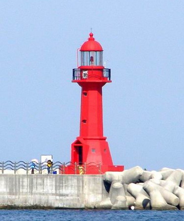
Pohang New Port North Breakwater Light
New Port North Breakwater Light, Pohang, May 2009
photo copyright John H. Lee; used by permission
Pohang City Northern Ward Lighthouses

Songla Township Lighthouses
* Jigyeong Hang Breakwater
Date unknown. Active; focal plane 15 m (49 ft); red flash every 5 s. 10 m (33 ft) round cylindrical concrete tower, painted red. Oh Tae-pil has a 2023 photo and Google has a street view and a satellite view. Located at the end of the main breakwater of Jigyeong harbor, about 16 km (10 mi) north of Pohang. Accessible by walking the pier. Site open, tower closed. KR-1299.5; Admiralty M4413.65; NGA 16611.5.
* Hwajin Hang North Breakwater
Date unknown. Active; focal plane 14 m (46 ft); green flash every 4 s. 10 m (33 ft) round cylindrical concrete tower, painted white. A 2022 photo is available, Google has a street view and a distant satellite view. Located at the north end of the north (really east) breakwater at Hwajin. Accessible by walking the pier. Site open, tower closed. KR-1301.4; Admiralty M4413.638; NGA 16611.6.
* Hwajin Hang South Breakwater
Date unknown. Active; focal plane 12 m (39 ft); green flash every 5 s. 11 m (36 ft) round cylindrical concrete tower, painted white. A photo is available and Google has a street view and a satellite view. Located at the end of the breakwater of the south harbor at Hwajin. Accessible by walking the pier. Site open, tower closed. KR-1301.5; Admiralty M4413.636; NGA 16611.65.
* Bangseok Hang North Breakwater
2015. Active; focal plane 14 m (46 ft); red flash every 5 s. 10 m (33 ft) round cylindrical concrete tower, painted red. A distant view is available and Google has a street view and a distant satellite view. Located at the end of the main breakwater of Bangseok harbor. Accessible by walking the pier. Site open, tower closed. Admiralty M4413.632; NGA 16611.7.
* Josa Hang Breakwater
Date unknown. Active; focal plane 14 m (46 ft); red flash every 4 s. 10 m (33 ft) round cylindrical concrete tower, painted red. A 2021 distant view is available and Google has a satellite view. Located at the end of the main breakwater of Josa harbor, about 10 km (6 mi) north of Pohang. Accessible by walking the pier. Site open, tower closed. KR-1301.3; Admiralty M4413.63; NGA 16611.8.

Cheongha Township Lighthouses
* Bangeori Hang Breakwater
2014. Active; focal plane 14 m (46 ft); red flash every 5 s. 10 m (33 ft) round cylindrical concrete tower, painted red. Kim Ki-cheon has a photo and Google has a street view and a distant satellite view. Located at the end of the main breakwater of Bangeori harbor. Accessible by walking the pier. Site open, tower closed. KR-1301.8; Admiralty M4413.628.
* Walpo Hang Breakwater
2014. Active; focal plane 14 m (46 ft); red light, characteristic unknown. 10 m (33 ft) round cylindrical concrete tower, painted red. Google has a street view and a distant satellite view. Located at the end of the main breakwater of Walpo harbor. Accessible by walking the pier. Site open, tower closed. KR-1301.10; Admiralty M4413.627.
* Igari Hang North Breakwater
Date unknown. Active; focal plane 13 m (43 ft); red flash every 5 s. 10 m (33 ft) round cylindrical concrete tower, painted red. Samgwan Yoo has a photo, Seo Eun-soo has a 2022 photo of the light in action, and Google has street view and a satellite view. Located at the end of the north (really west) breakwater of Igari harbor, in the lee of the Weolpo Man headland (next entry). Accessible by walking the pier. Site open, tower closed. KR-1301.7; Admiralty M4413.625; NGA 16611.9.
* Wolpo Man
Date unknown. Active; focal plane 24 m (79 ft); white flash every 7 s. 10 m (33 ft) round cylindrical concrete tower, painted white. Google has a street view and a satellite view. Located on a headland about 15 km (9 mi) north of Pohang. Site open, tower closed. KR-1302; Admiralty M4413.6; NGA 16612.
* Cheongjin Hang North Harbor Breakwater
Date unknown (around 2017). Active; focal plane about 18 m (59 ft); Byeol Kim has a 2018 photo and Google has a satellite view. Street views show that this light was not present in 2015. Located at a harbor about 800 m (1/2 mi) north of the older Cheongjin harbor. Accessible by walking the pier. Site open, tower closed. KR-1301.11; Admiralty M4413.59.
* Cheongjin Hang North Breakwater
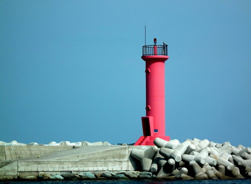
2009. Active; focal plane about 19 m (62 ft); red flash every 4 s. 10 m (33 ft) round cylindrical concrete tower, painted red. John H. Lee's photo is at right and Google has a street view and a satellite view. Located at the end of the east (main) breakwater of Cheongjin. Accessible by walking the pier. Site open, tower closed. KR-1301.6; Admiralty M4413.58; NGA 16612.2.
Cheongjin Hang Light
Cheongjin Hang North Breakwater Light, Pohang, October 2010
photo copyright John H. Lee; used by permission
Heunghae Town Lighthouses
Odo
2016. Active; focal plane 15 m (49 ft); three quick white flashes every 10 s. 11 m (36 ft) round cylindrical concrete tower painted black with a yellow horizontal band. Lee Hee-gwan has a view from shore, Google has a distant street view, and Bing has an indistinct satellite view. Located on a rocky reef off the village of Odo. Accessible only by boat, but easy to see from shore. Site open, tower closed. KR-1302.2; Admiralty M4413.57; NGA 16612.3.
Odo Hang
2019. Active; focal plane 13 m (43 ft); three red flashes every 7 s. 9 m (30 ft) octagonal red concrete tower. No photo available but Google has a satellite view. Located on the breakwater of a small harbor sheltered by the Odo reef. Accessible by walking the pier. Site open, tower closed. KR-1302.9; Admiralty M4413.56.
* Chilpo Hang East Breakwater
Date unknown. Active; focal plane 14 m (46 ft); red flash every 5 s. 10 m (33 ft) round cylindrical concrete tower, painted red. Baek Seung-min has a view from shore and Google has a street view and a satellite view. Located at the end of the east (main) breakwater of Chilpo harbor. Accessible by walking the pier. Site open, tower closed. KR-1302.1; Admiralty M4413.55; NGA 16612.5.
Yeongilmanhang (Pohang New Port) Detached Breakwater North End
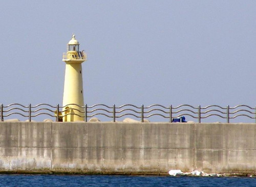
Date unknown. Active; focal plane 20 m (66 ft); four yellow flashes every 6 s. 22 m (72 ft) (?) round concrete tower with lantern and gallery, painted a pale yellow. John H. Lee's photo is at right, Kyung Mok Park has a distant street view, and Google has a satellite view. Located at the north end of a long breakwater built to protect a containership port about 10 km (6 mi) northeast of Pohang. Accessible only by boat. The 3 km (1.8 mi) long breakwater is open to fishermen. Site open, tower closed. KR-1302.5; Admiralty M4410.8; NGA 16613.
Pohang New Port Light
New Port Detached Breakwater North End Light, Pohang, May 2009
photo copyright John H. Lee; used by permission
* Yeongilmanhang (Pohang New Port) North Breakwater
Date unknown. Active; focal plane 15 m (49 ft). 14 m (46 ft) octagonal concrete tower with lantern and gallery, mounted on an octagonal concrete base. Lighthouse painted red. John H. Lee's photo is at the top of this page, Won-rak Lee has a more distant view, and Google has a satellite view. In a 2013 Notice to Mariners the tower was described as being yellow. Located at the end of the north breakwater of Pohang's new port. Accessible by walking the breakwater. Site open, tower closed. Admiralty M4410.6; NGA 16614.
Yeongilmanhang (Pohang New Port) Detached Breakwater South End
Date unknown. Active; focal plane 31 m (105 ft); two red flashes every 5 s. 25 m (82 ft) square concrete tower painted red. Kiljae Lee has a closeup photo, Park Dae-ho has a distant view, and Google has a satellite view. Located at the south end of the long breakwater built to protect the new port. Accessible only by boat. KR-1308; Admiralty M4410.9; NGA 16613.5.
Yeongilmanhang (Pohang New Port) South Detached Breakwater North End
Date unknown. Active; focal plane 31 m (105 ft); two green flashes every 6 s. 28 m (92 ft) square white concrete tower. No photo available but Google has a satellite view. Located at the north end of a detached breakwater protecting the south side of the new port. Accessible only by boat. KR-1310.1; Admiralty M4410.94; NGA 16615.8.

Pohang North Urban District Lighthouse
Yeonamgap (Yonamgup, Pohang)
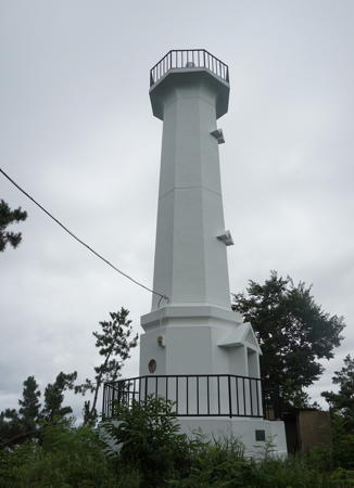
Date unknown. Active; focal plane 33 m (108 ft); white flash every 5 s. 14 m (46 ft) octagonal white concrete tower. A closeup photo is at right, a second closeup (second photo on the page) and a 2023 closeup are available, and Google has a satellite view. The relative lack of photos of this important lighthouse is remarkable. Located on a headland about 6 km (3.5 mi) northeast of Pohang. Site status unnown. KR-1313; Admiralty M4410.5; NGA 16616.
 

Yeonamgap Light, Pohang, August 2021
photo from SeMyung newspaper blog
 

Pohang City Southern Ward Lighthouses

Pohang South Urban District (Pohang Harbor) Lighthouses
Pohang's traditional harbor is at the head of Yeongil Bay, a broad inlet of the East Sea sheltered on the east by the Homigot ("Tiger's Tail") Peninsula, a hilly and scenic peninsula about 15 km (9 mi) long. The peninsula is the easternmost land of the South Korean mainland.
* Pohang Old Port East Breakwater
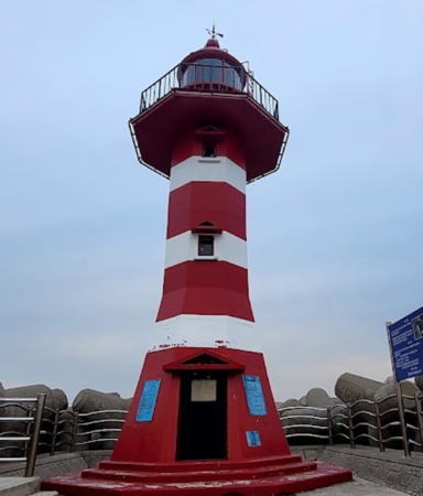
Date unknown. Active; focal plane 13 m (43 ft); red flash every 5 s. 10 m (33 ft) tapered octagonal concrete tower with lantern and gallery, painted red with narrow white horizontal bands. Seungkook Kim has the 2023 photo at right and Google has a good satellite view and a distant street view. The tower was formerly all red, as seen in Byungsung Lim's 2017 photo. Located at the end of the main (east) breakwater of Pohang's traditional harbor. Accessible by walking the breakwater. Site open, tower closed. KR-1316; Admiralty M4413.2; NGA 16620.
* Pohang Old Port South Breakwater
Date unknown. Active; focal plane 13 m (43 ft); green flash every 5 s. 10 m (33 ft) round cylindrical white concrete tower. Helen Kinuthia has a distant view and Google has a street view and a satellite view. Located at the end of the short south breakwater of Pohang's traditional harbor. Accessible by walking the pier. Site and tower closed. KR-1317; Admiralty M4413; NGA 16620.5.
Pohang Shinhang (Outer Harbor) North Breakwater
Date unknown. Active; focal plane 20 m (66 ft); red flash every 6 s. 15 m (49 ft) octagonal concrete tower with lantern and gallery, painted red. No photo available but Google has a satellite view. Large new harbor facilities have been built on the east side of the city of Pohang to serve the Posco (Pohang Steel Company) plant. Located at an elbow of the north breakwater, marking the entrance to the new harbor. Site status unknown. KR-1332; Admiralty M4411; NGA 16636.
Pohang Shinhang
Date unknown. Active; focal plane 72 m (236 ft); continuous light, white, red or green depending on direction. 69 m (226 ft) square tapered skeletal tower, painted white. This is a leading light for vessels entering the new harbor. No photo available but Google has a satellite view. Located on the Posco quay. Site status unknown. Admiralty M4412; NGA 16624.
Pohang Shinhang Range Front
Date unknown. Active; focal plane 35 m (115 ft); continuous green light. 30 m (98 ft) square tapered skeletal tower. No photo available but Google has a satellite view. This is the approach range for the harbor. Located on the south breakwater of the harbor. Site status unknown. Admiralty M4411.4; NGA 16626.
Pohang Shinhang Range Rear
Date unknown. Active; focal plane 73 m (240 ft); continuous green light. 70 m (230 ft) square tapered skeletal tower. No photo available but Google has a satellite view. Located on a major quay of the harbor, 1290 m (0.8 mi) south southwest of the front light. Site status unknown. Admiralty M4411.41; NGA 16627.
 

Old Port East Breakwater Light, Pohang, May 2023
Google Maps photo by Seungkook Kim
Pohang Shinhang Outer Detached Breakwater West End
Date unknown. Active; focal plane 10 m (33 ft); green flash every 4 s. 7 m (23 ft) round white fiberglass tower. No photo available but Google has a satellite view. Located at the west end of an outer breakwater of the harbor. Accessible only by boat. Site status unknown. KR-1322; Admiralty M4412.72; NGA 16633.
Pohang Shinhang Outer Detached Breakwater East End
Date unknown. Active; focal plane 10 m (33 ft); red flash every 4 s. 7 m (23 ft) round red fiberglass tower. No photo available but Google has a satellite view. Located at the east end of an outer breakwater of the harbor. Accessible only by boat. Site status unknown. KR-1321; Admiralty M4412.7; NGA 16634.
Pohang Shinhang Inner Detached Breakwater West End (2)
Date unknown. Active; focal plane 10 m (33 ft); two green flashes every 6 s. 7.5 m (25 ft) round white foberglass tower. The original lighthouse, a 10 m (33 ft) octagonal white concrete tower, was replaced in 2019. Photos of both breakwater lights are available and Google has a satellite view. Located at the west end of an inner breakwater of the harbor. Accessible only by boat. Site status unknown. KR-1323; Admiralty M4412.6; NGA 16628.
Pohang Shinhang Inner Detached Breakwater East End
Date unknown. Active; focal plane 12 m (39 ft); red flash every 5 s. 10 m (33 ft) octagonal concrete tower, painted red. Photos of both breakwater lights are available and Google has a satellite view. Located at the east end of an inner breakwater of the harbor. Accessible only by boat. Site status unknown. KR-1325; Admiralty M4412.5; NGA 16632.
Pohang Shinhang (Outer Harbor) South Breakwater
Date unknown. Active; focal plane 17 m (56 ft); green flash every 6 s. 13 m (43 ft) round concrete tower, painted white. No photo available but Google has a satellite view. Located at the end of the south breakwater of the harbor. Site status unknown. KR-1329; Admiralty M4411.2; NGA 16640.

Donghae Township (Homigot Peninsula West Coast) Lighthouses
* Balsan South Breakwater
Date unknown. Active; focal plane 12 m (39 ft); red flash every 4 s. 10 m (33 ft) round cylindrical concrete tower, painted red. Google has a street view and a satellite view. Located at a small boat harbor on the west side of the Homigot Peninsula. Accessible by walking the pier. Site open, tower closed. KR-1338.5; Admiralty M4408.5; NGA 16642.5.
* Balsan North Breakwater
Date unknown. Active; focal plane 14 m (46 ft); green flash every 4 s. 10 m (33 ft) round cylindrical concrete tower, painted white. Google has a street view and a satellite view. Located at a small boat harbor on the west side of the Homigot Peninsula. Accessible by walking the pier. Site open, tower closed. KR-1338.6; Admiralty M4408.55; NGA 16642.6.

Homigot Township (Cape Homi Area) Lighthouses
* Daedongbae Hang Section 2 North Breakwater
2019. Active; focal plane 14 m (46 ft); two green flashes every 6 s. 8 m (26 ft) octagonal white concrete tower. A distant view is available and Google has a satellite view. "Section 2" refers to the more northern of two small boat harbors at Daedongbae village. Located about 4 km (2.5 mi0 southwest of Homigot (Cape Homi). Accessible by walking the pier. Site open, tower closed. Admiralty M4407.
Gyoseokcho (Kyosokcho) (2)
2007(?) (station establishment date unknown). Active; focal plane 15 m (49 ft); green flash every 5 s. 20 m (66 ft) round cylindrical concrete tower, painted green. A 2018 photo is available and Google has a satellite view and a distant street view. The present lighthouse replaced a conical masonry tower. Located just off the extreme northern tip of Homigot (Cape Homi), about 1.6 km (1 mi) northwest of the Homigot lighthouse. Accessible only by boat, but there are good views from shore. Site open, tower closed. KR-1339; Admiralty M4409; NGA 16644.
* Daebo Hang (West Breakwater)
Date unknown. Active; focal plane 15 m (49 ft); red flash every 4 s. 8 m (26 ft) round mushroom-shaped concrete tower, painted red. Min Kyung-ho has a closeup photo, the light is in the background of the photo at right, and Google has a street view and a satellite view. Located at the end of the west breakwater of Daebo, a small harbor near the tip of Homigot (Cape Homi). Accessible by walking the breakwater. Site open, tower closed. KR-1340.1; Admiralty M4410; NGA 16648.
 
* Daebo Hang South Breakwater
Date unknown. Active; focal plane 13 m (43 ft); green flash every 4 s. 8.5 m (28 ft) round mushroom-shaped concrete tower, painted white. A 2021 closeup photo is at right, a second photo is available, and Google has a street view and a satellite view. Located at the end of the south breakwater of Daebo. Accessible by walking the breakwater. Site open, tower closed. KR-1341; Admiralty M4410.2; NGA 16648.5.

Daebo Hang Lights, Pohang, January 2021
Google Maps photo by Finn Huckleberry
**** Homigot (Hanggigot, Janggi Gab, Janggigot, Changgigot)
1908. Active; focal plane 31 m (102 ft); white flash every 12 s. 26 m (85 ft) tapered octagonal brick tower with lantern and gallery. Entire lighthouse painted white. A photo is at right, a 2018 closeup is available, Sarah Saunders has another good photo, Wikimedia has several photos, and Google has a street view and a satellite view of the station. This historic lighthouse was designed by French engineers and built by the Korean empire prior to the Japanese annexation. The light station is now the site of the Korean National Lighthouse Museum, which houses a broad range of artifacts including a 3rd order Japanese Fresnel lens (1953) from the Soheuksando lighthouse, a 4th order Fresnel lens (1910) from the Sorido lighthouse, and the original lantern and lens of the Budo lighthouse in Incheon. The museum has a page for the lighthouse. Located on Homigot (Cape Homi, called Janggigot under the Japanese), a broad cape that protects the east side of the bay of Pohang. Site open, lighthouse museum open daily except Mondays year-round, tower status unknown. Site manager: Korean National Lighthouse Museum. . ARLHS SKR-003; KR-1342; Admiralty M4406; NGA 16652.
* Gangsa (Kangsa) Hang Breakwater
Date unknown. Active; focal plane 12 m (39 ft); green flash every 5 s. 10 m (33 ft) round cylindrical concrete tower, painted white. Wonguy Shin has a view from the shore and Google has a street view and a distant satellite view. Located at the end of the main breakwater of Gangsa harbor, about 4 km (2.5 mi) south of the Homigot lighthouse. Accessible by walking the pier. Site open, tower closed. KR-1341.2; Admiralty M4405.6; NGA 16652.1.

Guryongpo Town (Homigot Peninsula East Coast) Lighthouses
* Seokbyeong North Harbor
Date unknown. Active; focal plane 12 m (39 ft); red flash every 4 s. 10 m (33 ft) round cylindrical concrete tower, painted red. Pavel Levinskiy has a 2018 photo and Google has a 2015 street view and a satellite view. Located on the east breakwater of a small boat harbor on the east side of the peninsula about 9 km (5.5 mi) south of the Homigot lighthouse. Accessible by walking the pier. Site open, tower closed. KR-1342.3; Admiralty M4405.55; NGA 16653.
* Seokbyeong
Date unknown. Active; focal plane 13 m (43 ft); red flash every 5 s. 10 m (33 ft) round cylindrical concrete tower, painted red. Moon Park has a 2021 photo and Google has a street view and a satellite view. Located on the east breakwater of a small boat harbor on the east side of the peninsula about 10 km (6 mi) south of the Homigot lighthouse. Accessible by walking the pier. Site open, tower closed. KR-1342.1; Admiralty M4404.6; NGA 16654.

Homigot Light, Pohang
Korean National Lighthouse Museum.photo
* Samjeong Hang Breakwater
2017. Active; focal plane 15 m (49 ft); red flash every 6 s. 10 m (33 ft) round cylindrical red concrete tower. A 2018 photo is available and Google has a street view and an indistinct satellite view. Located on the north breakwater at Samjeong, a short distance north of Saramal. Accessible by walking the pier. Site open, tower closed. Admiralty M4404.3; NGA 16655.1.
* Saramal (Sara Mal, Guryongpo Hang)
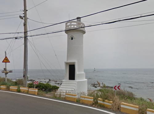
Date unknown. Active; focal plane 18 m (59 ft); white flash every 9 s. 10 m (33 ft) round cylindrical white concrete tower. Google has a street view (also seen at right) and a satellite view. Guryongpo is a fishing harbor at the base of the Homigot peninsula, about 16 km (10 mi) east of Pohang and a similar distance south of Cape Homi. Located on the headland north of the harbor. Site open, tower closed; the lighthouse stands beside a highway but there is no parking nearby. Admiralty M4404; NGA 16656.
Saramal East
Date unknown. Active; focal plane 13 m (43 ft); three quick white flashes every 10 s. 13 m (43 ft) round cylindrical concrete tower with gallery, painted black with one yellow horizontal band. Google has a distant street view and Bing has a satellite view. Located on a reef about 800 m (1/2 mi) east of the Saramal headland. Accessible only by boat. Site open, tower closed. KR-1343.1; Admiralty M4404.1; NGA 16656.1.
* Guryongpo West (North) Breakwater
Date unknown. Active; focal plane 14 m (46 ft); red flash every 4 s. 10 m (33 ft) round cylindrical red concrete tower. Lee Soo-hyun has a closeup photo, Seokrak Choi has a 2023 photo, a photo of both breakwater lights is available, and Google has a satellite view and a very distant street view. Earlier photos of this light show a plain cylindrical tower. Located at the end of the north breakwater (listed as the west breakwater) at Guryongpo. Accessible by walking the pier. Site open, tower closed. KR-1344; Admiralty M4405; NGA 16660.

Saramal Light, Pohang, June 2015
Google Maps street view
* Guryongpo East (South) Breakwater
Date unknown. Active; focal plane 14 m (46 ft); green flash every 4 s. 10 m (33 ft) round cylindrical white concrete tower. A photo of both breakwater lights is available and Google has a satellite view and a very distant street view. Located at the end of the south breakwater (listed as the east breakwater) at Guryongpo. Accessible by walking the pier. Site open, tower closed. KR-1344.5;Admiralty M4405.5; NGA 16661.
* Janggil (Janggireo Hang) (2?)
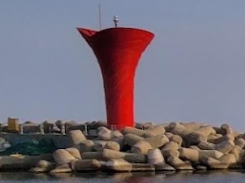
Date unknown. Active; focal plane 14 m (46 ft); red flash every 6 s. 10 m (33 ft) round vase-shaped concrete tower, painted red. Chris Lee's 2023 photo is at right, Lee Sang-cheon has a photo, and Google has a street view and a satellite view. Located at the end of the east breakwater of Janggil. Accessible by walking the pier. Site open, tower closed. KR-1344.8; Admiralty M4403.9; NGA 16661.3.
* Gupyeongponi Hang South Breakwater
Date unknown. Active; focal plane 12 m (39 ft); green flash every 5 s. 10 m (33 ft) round cylindrical concrete tower, painted white. Google has a street view and a satellite view. Located at the end of the south breakwater of Gupyeongponi, about 1.5 km (1 mi) south of Janggil. Accessible by walking the pier. Site open, tower closed. KR1344.10; Admiralty M4403.88; NGA 16661.4.

Janggi Township Lighthouses
Seogmaam
Date unknown. Active; focal plane 20 m (66 ft); two white flashes every 5 s. 13 m (43 ft) round concrete tower painted black with one red horizontal band. No photo available but Google has an indistinct satellite view and a very distant street view from shore. Located on a rocky reef about 2 km (1.25 mi) east of Mopo. Accessible only by boat. Site open, tower closed. KR-1344.9; Admiralty M4403.85; NGA 16661.6.

Janggil Light, Pohang, March 2023
Google Maps photo by Chris Lee
* Mopo Hang
Date unknown. Active; focal plane 15 m (49 ft); red flash every 5 s. 10 m (33 ft) round cylindrical concrete tower, painted red. A 2020 drone view is available and Google has a street view and a satellite view. Located at the end of the main breakwater of Mopo harbor. Accessible by walking the pier. Site open, tower closed. KR-1344.7; Admiralty M4403.8; NGA 16661.5.
* Yeongam North Breakwater
Date unknown. Active; focal plane 13 m (43 ft); red flash every 5 s. 10 m (33 ft) round cylindrical concrete tower, painted red. Jae. Deok Son has a photo and Google has a street view and a satellite view. Located at the end of the main breakwater of Yeongam harbor. Accessible by walking the pier. Site open, tower closed. Admiralty M4403.6; NGA 16661.61.
* Yangpo Outer Breakwater
Date unknown. Active; focal plane 14 m (46 ft); red flash every 4 s. 10 m (33 ft) round cylindrical red concrete tower. Hwang Bo Hwan has a 2019 photo and Google has a satellite view and a very distant street view. Located at the end of the main breakwater at Yangpo, a fishing port about 25 km (15 mi) southeast of Pohang. Accessible by walking the pier. Site open, tower closed. KR-1347; Admiralty M4403; NGA 16662.
Yangpo Hang
Date unknown. Active; focal plane about 15 m (49 ft); green light, pattern unknown. Approx. 15 m (49 ft) round green concrete tower. Hwang Bo Hwan has a 2019 photo and Google has a distant satellite view. Located on a shoal on the south side of the entrance to Yangpo harbor. Accessible only by boat. Site open, tower closed. KR-1347.4; Admiralty M4403.1.
* Yangpo
Date unknown. Active; focal plane 24 m (79 ft); white flash every 7 s. 9.5 m (31 ft) round white concrete tower. A photo is at right, Hwang Bo Hwan has a 2019 photo, and Google has a satellite view. Located on a promontory on the south side of Yangpo harbor. Site open, tower closed. Admiralty M4402; NGA 16664.
 

Yangpo Light, Pohang, July 2023
Google Maps photo by Céu de Luar
 

Information available on lost lighthouses:

Notable faux lighthouses:

Adjoining pages: North: Uljin Area | East: Ulleungdo and Dokdo | South: Gyeongju

Return to the Lighthouse Directory index | Ratings key

Posted October 29, 2007. Checked and revised November 4, 2023. Lighthouses: 53. Site copyright 2023 Russ Rowlett and the University of North Carolina at Chapel Hill.