Lighthouses of South Korea: Gyeongju

For most of its history Korea was an independent kingdom, or at least an autonomous kingdom under Chinese influence. This came to an end in 1910 when Japan annexed all of Korea. At the end of World War II in 1945 the 38° parallel was established as the dividing line between U.S. and Soviet zones of occupation, and in 1948 separate civil administrations were established in the two halves of the country. The Korean War (1950-53) ended in a draw with the armistice line falling close to the prewar 38° line. The Republic of Korea (ROK), commonly called South Korea, occupies the Korean peninsula south of the armistice line.

South Korea is divided into nine provinces and eight province-level cities. This page covers lighthouses of the city of Gyeongju in the southeastern corner of South Korea's province of North Gyeongsang (Gyeongsangbuk-do). With a population of about 275,000 Gyeongju is a medium-sized city located between the larger cities of Pohang to the north and Ulsan to the south. It has a scenic coast facing east on the East Sea (commonly called the Sea of Japan in the West).

Navigational aids in the ROK are regulated by the Ministry of Oceans and Fisheries (MOF). Management of lighthouses in North Gyeongsang is the responsibility of the Pohang Regional Office of Oceans and Fisheries. The Korean Hydrographic and Oceanographic Administration (KHOA) publishes notices to mariners.

In 2000 South Korea adopted a Revised Romanization System to replace systems formerly used in the West. In the Revised System, the word for a lighthouse is deungdae (등대); dan (formerly tan) is a cape, seom (som) or do (to) is an island, am or amseog is a rock, man is a bay, and hang is a harbor. Some place names may be more familiar to Westerners in the spellings of older systems.

The name Korea, used internationally, is a Western version of Goryeo or Koryŏ (고려), the name of a kingdom that unified the country in the tenth century. From 1392 to 1897 the kingdom was known instead as Joseon or Chosŏn (조선). Today South Koreans usually call their country Hanguk (한국, literally "one country") and the official name of the Republic of Korea is Daehan Minguk (대한민국).

ARLHS numbers are from the ARLHS World List of Lights. KR numbers, where available, are from the Korean light list. Admiralty numbers are from volume M of the Admiralty List of Lights & Fog Signals. U.S. NGA List numbers are from Publication 112.

General Sources
Pohang Region Lighthouses
Lighthouse information posted by the Pohang MOF office.
Lighthouses in South Korea
Photos by various photographers available from Wikimedia.
Online List of Lights - Korea
Photos by various photographers posted by Alexander Trabas.
Navionics Charts
Navigational chart of the Pohang area.
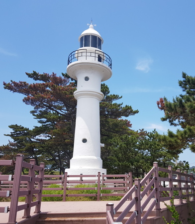


1968 Gampo Light, Gyeongju, May 2018
ex-Google Plus photo by 신종언 (Jong-un Shin)

Gampo Town Lighthouses

*
Yeondong Hang
Date unknown. Active; focal plane 12 m (39 ft); red flash every 5 s. 10 m (33 ft) round cylindrical red concrete tower. Ahn Seong-yong has a 2021 photo and Google has a street view and a satellite view. Located on the main breakwater of Yeondong harbor, about 6 km (4 mi) north of Gampo. Accessible by walking the pier. Site open, tower closed. KR-1347.3; Admiralty M4401.5.
* Cheoksa Hang (2)
2018. Active; focal plane 12 m (39 ft); red flash every 5 s. 10 m (33 ft) square red concrete and metal tower with lantern and gallery. A 2021 closeup photo is available, So-Youn Lee has a view from shore, and Google has a satellite view. Google's 2015 street view shows the previous light on the 6 m (20 ft) skeletal tower listed by NGA. Located on the main breakwater of Yeondong harbor, about 6 km (4 mi) north of Gampo. Accessible by walking the pier. Site open, tower closed. KR-1348.7; Admiralty M4401; NGA 16665.
* Gampo (Kampo, Songdae, Songdaemal) (3)
2001 (station established 1955). Active; focal plane 30 m (98 ft); flash every 17 s, alternately red and white. 14 m (46 ft) square pagoda-style tower with lantern and gallery, attached to a 2-story building. Lighthouse painted white. Ha Jeong's photo is at right, a 2019 photo is available, and Google has a street view and a satellite view of the station. This interesting lighthouse was intended from the start as a tourist attraction. The building is a historical museum. Located on a headland overlooking the harbor of Gampo, about 32 km (20 mi) south of Pohang. Site open, tower closed. Site manager: Songdaemal Light Exhibition Museum . KR-1348; ARLHS SKR-027; Admiralty M4400; NGA 16668.
* Gampo (Kampo, Songdae, Songdaemal) (2)
1968 (station established 1955). Presumably inactive since 2001. Approx. 15 m (49 ft) round concrete tower with lantern and gallery. Entire lighthouse is white. A photo is at the top of this page, Cho Taelim has a 2017 photo, a 2021 closeup and another photo are available, and Google has an indistinct satellite view. This lighthouse is close to the 2001 lighthouse but down a steep slope. Site open, tower closed.
Gwanam
Date unknown. Active; focal plane 18 m (59 ft); six quick white flashes followed by one long white flash every 15 s. 17 m (56 ft) round concrete tower mounted on a large round concrete base. Tower painted yellow, base black. Kim So-won has a 2021 closeup photo, Lee San-pil has a photo, Jeong Cheol has a 2018 photo, and Google has a street view and a satellite view. Located on a rocky reef about 250 m (800 ft) offshore southeast of the Gampo lighthouses. Accessible only by boat. Site status unknown. KR-1348.5; Admiralty M4399.5; NGA 16669.

2001 Gampo Light, Gyeongju, February 2021
Flickr Creative Commons photo by Ha Jeong
Gampo North Breakwater
Date unknown. Active; focal plane 15 m (49 ft); red flash every 4 s. 11 m (36 ft) round cylindrical concrete tower, painted red. This lighthouse is on the left in Beomwon Moon's 2019 photo, a 2020 photo is available, and Google has a street view and a satellite view. Located at the end of the north breakwater of Gampo harbor. Site status unknown. KR-1350.4; Admiralty M4398.2; NGA 16672.1.
Gampo West Breakwater (2)
2016. Active; focal plane 15 m (49 ft); two green flashes every 6 s.. 16 m (52 ft) square concrete tower with lantern and gallery. Lighthouse painted white. The sides of the tower have large cutouts, as seen in the closeup photo by Cho Jongpil seen at right. A 2020 photo is available and Google has a fuzzy satellite view. The March 2015 street view was taken before the lighthouse was built. Previously the light was on a concrete post attached to a square concrete equipment shelter. It was removed in 2015 and dropped from the NGA List. The new light was announced in July 2016. Located on an inner breakwater of Gampo harbor. Site status unknown. KR-1349; Admiralty M4398; ex-NGA 16672.
Gampo Hang South Breakwater (3)
Date unknown (2016 or later). Active; focal plane 13 m (43 ft); two green flashes every 6 s. 17 m (56 ft) osquare concrete tower with lantern and gallery. Lighthouse painted white. The sides of the tower have large cutouts like those of the West Breakwater light. A 2020 photo and a 2023 photo are available and Google has a satellite view. NGA lists this light as "N. Kamp'o Hang." This lighthouse replaced an octagonal cylindrical white concrete tower with lantern and gallery. Located at the end of the original south breakwater of Gampo harbor. Site status unknown. KR-1350.1; Admiralty M4399.2; NGA 16672.2.
* Jeonchon Hang North Breakwater
Date unknown. Active; focal plane 15 m (49 ft); red flash every 5 s. 10 m (33 ft) round cylindrical concrete tower, painted red. Jong Ho Lee has a 2019 photo, Kei Unggaro has a street view from the nearby beach, and Google has a satellite view. Located at the end of the north breakwater at Jeonchon, a fishing port about 2.5 km (1.5 mi) south of the Gampo lighthouse. Presumably accessible by walking the pier. Site open, tower closed. KR-1350.5; Admiralty M4397.85; NGA 16672.3.
* Jeonchon Hang South Breakwater
Date unknown. Active; focal plane 14 m (46 ft); green flash every 5 s. 10 m (33 ft) round cylindrical white concrete tower. Jong Ho Lee has a 2019 photo, Kei Unggaro has a street view from the nearby beach, and Google has a satellite view. Located at the end of the south breakwater at Jeonchon. Presumably accessible by walking the pier. Site open, tower closed. KR-1350.8; Admiralty M4397.86; NGA 16672.5.
* Gagok Hang
Date unknown. Active; focal plane about 13 m (43 ft); red flashing light. Approx. 10 m (33 ft) round cylindrical concrete tower, painted red. A closeup photo is available and Google has a street view and a satellite view. Located on the main breakwater of Gagok harbor. Presumably accessible by walking the pier. Site open, tower closed. KR-1350.3; Admiralty M4397.8.


West Breakwater Light, Gampo, October 2017
Google Plus photo by 최종필 (Cho Jongpil)

* Daebon Hang (2)
Date unknown. Active; focal plane about 13 m (43 ft); red flashing light. Approx. 10 m (33 ft) octagonal red cylindrical concrete tower. Park Chulsoo has a 2020 closeup photo, Jae Hyung Lee has a view from shore, and Google has a satellite view. This light replaced a post light seen in a 2015 street view; Park Young-Seo's 2019 photo shows the old light standing next to the new one. Located on the main breakwater at Daebon. Presumably accessible by walking the pier. Site open, tower closed. Admiralty M4397.796.

Yangnam Township Lighthouses
Naa Outer Breakwater
Date unknown. Active; focal plane about 13 m (43 ft); red flash every 4 s. Approx. 10 m (33 ft) round cylindrical concrete tower, painted red. No photo available. Google has a satellite view and a very distant street view. The harbor at Naa serves the Wolseong Nuclear Power Plant. Located on the main breakwater of the harbor. Site and tower closed. KR-1350.12; Admiralty M4397.791.
Naa Inner Breakwater
Date unknown. Active; focal plane about 13 m (43 ft); green flash every 4 s . Approx. 10 m (33 ft) round cylindrical concrete tower, painted white. No photo available. Google has a satellite view and a very distant street view. Located on the south breakwater of the harbor. Site and tower closed. KR-1350.11; Admiralty M4397.79.
Jukjeonan (Eupchon North)
Date unknown. Active; focal plane 15 m (49 ft); two yellow flashes evry 6 s. 8.5 m (28 ft) stainless steel tower painted yellow. A 2020 photo is available, J.Y. Yang has a view from shore, and Google has a street view and a satellite view. Located on the breakwater of a small harbor south of Naa and on the north side of Eupchon. Site status unknown. KR-1351.8; Admiralty M4397.77; NGA 16672.6.
Eupchon (Upchon) Hang North Breakwater (2)
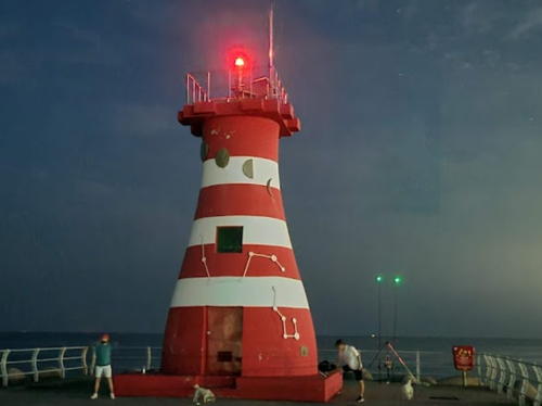
Date unknown. Active; focal plane 15 m (49 ft); red flash every 4 s. 10 m (33 ft) round bottle-shaped concrete tower painted with red and white horizontal bands (unusual for Korea). Seonghwan Kim's photo is at right, ByungJune Ahn has a photo also showing the entrance light (see below), and Google has a 2019 street view and a satellite view. This light replaced a round cylindrical tower seen in Yongho To's 2014 street view. Located on the north breakwater at Upchon, about 30 km (19 mi) north of Ulsan. Site status unknown. KR-1351; Admiralty M4397.7; NGA 16672.7.

Eupchon North Breakwater Light, Yangnam, August 2022
Google Maps photo by Seonghwan Kim
Eupchon (Upchon) Hang South Breakwater
Date unknown. Active; focal plane 12 m (39 ft); green flash every 5 s. 8 m (26 ft) round cylindrical concrete tower, painted white. Yoo Woong-yeol's photo is at right, Seok-Oh Pil has a 2019 photo, Yongho To has a street view and Google has a satellite view and a closeup 2019 street view. Located on the south breakwater at Upchon, about 30 km (19 mi) north of Ulsan. Site status unknown. KR-1351.5; Admiralty M4397.75.
Eupchon (Upchon) Hang Entrance
Date unknown. Active; focal plane 15 m (49 ft); green flash every 5 s. 15 m (49 ft) round cylindrical green concrete tower with lantern and gallery mounted on a square concrete pier. Anthony Chang has 2023 photo, ByungJune Ahn has a photo also showing the north breakwater light, Google has a street view and a satellite view. Located on a shoal south of the north breakwater light. Accessible only by boat but easy to view from shore. Site open, tower closed. KR-1351.16; Admiralty M4397.698.
* Suryeom Hang
Date unknown (2017?). Active; focal plane about 13 m (43 ft); two red flashes every 4 s. Approx. 10 m (33 ft) round cylindrical concrete tower, painted red. The Yangnam Elementary School has a closeup photo, Lee In-gyu has a photo, and Google has a satellite view, but the tower is too new to appear in Google's 2015 street view. Located on the main breakwater of Suryeom harbor. Accessible by walking the pier. Site open, tower closed. KR-1351.14; Admiralty M4397.695.
* Jigyeong Hang
Date unknown. Active; focal plane about 13 m (43 ft); red light, characteristic unknown. Approx. 10 m (33 ft) round cylindrical concrete tower, painted red. A 2021 photo is available and Google has a street view and a satellite view. Located on the main breakwater of Jigyeong harbor, just north of the Ulsan City limit. Accessible by walking the pier. Site open, tower closed. KR-1351.7; Admiralty M4397.69.

Eupchon South Breakwater Light, Yangnam, May 2021
Google Maps photo by Yoo Woong-yeol

Information available on lost lighthouses:

Notable faux lighthouses:

Adjoining pages: North: Pohang | East: Ulleungdo and Dokdo | South: Ulsan

Return to the Lighthouse Directory index | Ratings key

Posted October 29, 2007. Checked and revised November 12, 2023. Lighthouses: 20. Site copyright 2023 Russ Rowlett and the University of North Carolina at Chapel Hill.