Lighthouses of South Korea: Ulsan

For most of its history Korea was an independent kingdom, or at least an autonomous kingdom under Chinese influence. This came to an end in 1910 when Japan annexed all of Korea. At the end of World War II in 1945 the 38° parallel was established as the dividing line between U.S. and Soviet zones of occupation, and in 1948 separate civil administrations were established in the two halves of the country. The Korean War (1950-53) ended in a draw with the armistice line falling close to the prewar 38° line. The Republic of Korea (ROK), commonly called South Korea, occupies the Korean peninsula south of the armistice line.

South Korea is divided into nine provinces and eight province-level cities. This page covers lighthouses of the metropolitan (province-level) city of Ulsan on South Korea's southeastern coast. The home of Hyundai Industries, Ulsan is a large, rapidly growing industrial city and seaport about 35 km (22 mi) northeast of Busan. Itspopulation is more than 1.1 million. The Hyundai companies operate the world's largest shipyard and largest automobile assembly plant in the city. The city is divided into four districts (gu) and one county (gun).

Navigational aids in the ROK are regulated by the Ministry of Oceans and Fisheries (MOF). Management of lighthouses in Ulsan is the responsibility of the Ulsan Regional Oceans and Fisheries Administration. The Korean Hydrographic and Oceanographic Administration (KHOA) publishes notices to mariners.

In 2000 South Korea adopted a Revised Romanization System to replace systems formerly used in the West. In the Revised System, the word for a lighthouse is deungdae (등대); dan (formerly tan) is a cape, seom (som) or do (to) is an island, am or amseog is a rock, man is a bay, and hang is a harbor. Some place names may be more familiar to Westerners in the spellings of older systems.

The name Korea, used internationally, is a Western version of Goryeo or Koryŏ (고려), the name of a kingdom that unified the country in the tenth century. From 1392 to 1897 the kingdom was known instead as Joseon or Chosŏn (조선). Today South Koreans usually call their country Hanguk (한국, literally "one country") and the official name of the Republic of Korea is Daehan Minguk (대한민국).

ARLHS numbers are from the ARLHS World List of Lights. KR numbers, where available, are from the Korean light list. Admiralty numbers are from volume M of the Admiralty List of Lights & Fog Signals. U.S. NGA List numbers are from Publication 112.

General Sources
Navigational Aid
Information about the major lighthouses posted by Ulsan port authorities.
World of Lighthouses - South Korea
Photos by various photographers available from Lightphotos.net.
Lighthouses in South Korea
Photos by various photographers available from Wikimedia.
Online List of Lights - Korea
Photos by various photographers posted by Alexander Trabas.
Navionics Charts
Navigational chart of the Ulsan area.
 

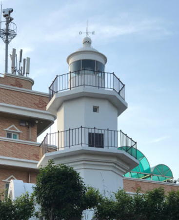
Seul Do Breakwater Elbow Light
Seuldo Breakwater Elbow Light, Ulsan, July 2010
ex-Panoramio Creative Commons photo by G. Horpestad
Buk-gu (Northern District) Lighthouses
Jeongja (Chongja) Hang Outer Breakwater
Date unknown. Active; focal plane 17 m (56 ft); green flash every 4 s. 11 m (36 ft) round cylindrical concrete tower, painted white. Yang-Hoon Lee has a photo, this is the lighthouse on the left in an older photo of all three Jeongja lighthouses, Hyunwook Kim has a street view, and Google has a satellite view. Located at the north end of a short breakwater outside the Jeongja harbor entrance. Accessible only by boat. Site status unknown. KR-1353.2; Admiralty M4397.6.
* Jeongja (Chongja) Hang North Breakwater (2)
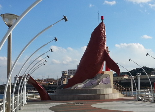
Date unknown. Active; focal plane 16 m (52 ft); two red flashes every 6 s. 11 m (36 ft) sculpture of a whale; the light is perched above the whale's nose. Entire lighthouse is red. Yang-Hoon Lee's 2013 photo is at right, Hyunwook Kim has a 2017 street view, G.S. Byeon has a 2022 photo, and Google has a satellite view. The original lighthouse is the only red lighthouse in a photo of all three Jeongja lighthouses. This unusual design was selected after a public competition. Formerly a whaling port, Ulsan calls itself "Whale City," has a whale museum, and is a base for whale-watching cruises. Accessible by walking the pier. Located on the north breakwater of Chongja harbor, about 16 km (10 mi) northeast of Ulsan. Site status unknown. KR-1352; Admiralty M4397.4; NGA 16673.
* Jeongja (Chongja) Hang South Breakwater (2)
Date unknown. Active; focal plane 16 m (52 ft); green flash every 6 s. 11 m (36 ft) sculpture of a whale; the light is perched above the whale's nose. Entire lighthouse is white. Hyunwook Kim has a street view, and Google has a satellite view. The original lighthouse is the lighthouse on the right in a photo of all three Jeongja lighthouses. Accessible by walking the pier. Located on the south breakwater of Jeongja harbor, about 16 km (10 mi) northeast of Ulsan. Site status unknown. KR-1353; Admiralty M4397.5; NGA 16673.1.
Jeongja North Breakwater Light
Jeongja North Breakwater Light, Buk-gu, Ulsan, November 2013
Google Maps (ex-Panoramio) photo by Yang-Hoon Lee
* Dangsa Hang
Date unknown. Active; focal plane 13 m (43 ft); two green flashes every 6 s. 10 m (33 ft) octagonal cylindrical white concrete tower with a "mushroom" top. The top is black above. Lim Bok Yu has a photo, another photo is available, and Google has a satellite view. Located on the south breakwater of Dangsa harbor. Accessible by walking the pier. Site open, tower closed. KR-1353.3; Admiralty M4397.2.
Eomul Hang
2016. Active; focal plane 15 m (49 ft); red flash every 4 s. 9 m (30 ft) round cylindrical red metal tower with a silver "cap" at the top. Park Min-soo has a photo and Google has a photo and an indistinct satellite view. Located on the north breakwater of Eomul harbor. Site status unknown. Admiralty M4396.95.

Dong-gu (Eastern District, Pangoji Area) Lighthouses
Ideokso (Idokso)
Date unknown. Active; focal plane 14 m (46 ft); two white flashes every 5 s. 16 m (52 ft) round cylindrical concrete tower with gallery, painted black with one red horizontal band. Google has a very distant street view but the tower is not seen in Google's satellite view. Located on a rock about 1.5 km (1 mi) offshore and 10 km (6 mi) north of Pangoji. Accessible only by boat. Site open, tower closed. KR-1354; Admiralty M4397; NGA 16674.
* Jujeon Hang East Breakwater (2)
2011. Active; focal plane about 16 m (52 ft); red flash every 5 s. Approx. 12 m (39 ft) mast atop a 3-story pagoda-style building. Entire lighthouse is red. Lee Jong-tae has a 2017 photo, Park Ki-soo has a photo, and Google has a satellite view. Located at the end of the north breakwater of Jujeon harbor, about 5 km (3 mi) north of Pangoji. Accessible by walking the pier. Site open, tower closed. KR-1354.1; Admiralty M4396.8; NGA 16675.
#Mipo North Breakwater (1)
Date unknown. Active; focal plane 18 m (59 ft); red flash every 5 s. This was a 15 m (49 ft) round concrete tower with lantern and gallery, painted red. No photo available and Google's satellite view shows that the tower has been replaced by a smaller light. The Mipo harbor is operated by the Hyundai corporation. Located on the north (outer) breakwater of the industrial Mipo harbor, at the north end of Pangoji. Site and tower closed. KR-1355; Admiralty M4396.5; NGA 16680.9.
Mipo South Breakwater
Date unknown. Active; focal plane 18 m (59 ft); green flash every 5 s. 15 m (49 ft) round cylindrical concrete tower with lantern and gallery, painted white. No photo available but Google has a satellite view. Located on the south breakwater of Mipo harbor. Site and tower closed. Admiralty M4396.6; NGA 16681.2.
Jeonhaman
Date unknown. Active; focal plane 16 m (52 ft); two red flashes every 6 s. 9 m (30 ft) round red tower, apparently with a buttressed base. No photo available but Google has an indistinct satellite view. Located on the north breakwater of the Jeonha industrial harbor basin about 1.5 km (1 mi) south of the Mipo basin. Site and tower closed. Admiralty M4395; NGA 16682.
Ilsan Hang
Date unknown. Active; focal plane 17 m (56 ft); six quick white flashes followed by one long white flash every 15 s. 19 m (62 ft) round cylindrical concrete tower with gallery. Upper half of the tower painted yellow, lower half black. Kim Heon Ho has a photo and Google has a satellite view. Located just off a rocky reef in Ilsan harbor at the south end of the Hyundai complex. Accessible only by boat. Site status unknown. KR-1357.1; Admiralty M4394.5; NGA 16683.
* Ulgi (Daewangam) (1)
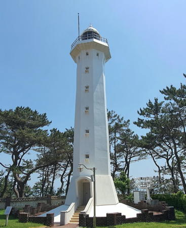
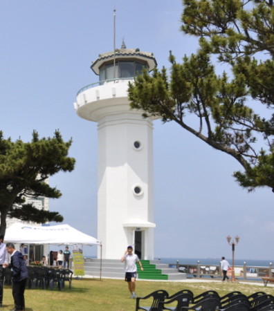
1906. Inactive since 1994. 6 m (20 ft) 2-stage octagonal cylindrical concrete tower with lantern and double gallery. Entire lighthouse is white. Hyunwook Kim's photo is above right, Kim Gap-hwan has a 2019 closeup photo, Malcolm Skinner has a photo, Wikimedia has a closeup, and Google has a street view and a satellite view. The lighthouse was increased in height by 3 m (10 ft) in 1972. There was a restoration of the tower in 2000. The lighthouse is located in Ulgi Park, which occupies a wooded peninsula jutting northeastward into the East Sea at Pangoji, on the east side of Ulsan. Located at the tip of the peninsula. Site open, tower closed.
* Ulgi (Daewangam) (2)
1994 (station established 1906). Active; focal plane 52 m (171 ft); white flash every 10 s. 24 m (79 ft) octagonal cylindrical concrete tower with lantern and gallery. Entire lighthouse is white. A photo is at right, Malcolm Skinner has a photo, a good 2006 photo is available, Joshua Klein has a view from the sea, Wikimedia has a photo and the closeup seen at right, and Google has a satellite view and a closeup street view. The station includes the navigation control headquarters for Pangoji. Located close to the historic lighthouse. Site open, tower closed. . ARLHS SKR-048; KR-1357; Admiralty M4394; NGA 16680.

Nam-gu (Southern District, Ulsan Harbor) Lighthouses
** Seul Do (Seuldo) (Breakwater Elbow) (2)
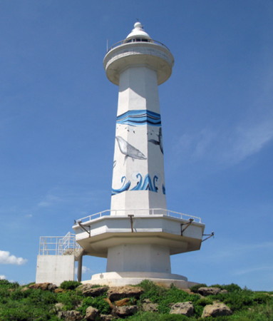
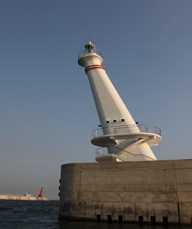
2008(?). Active; focal plane 23 m (75 ft); white flash every 6 s. 16 m (52 ft) octagonal concrete tower with lantern and upper and lower galleries. The lighthouse is white with a mural of whales painted around the tower. G. Horpestad's photo is at the top of this page, Yongho Row has a 2021 photo, a 2016 photo is available, Eunsil Lim has a more distant view, Choi Hyujin has a street view, and Google has a satellite view. This lighthouse replaced a plain round white concrete tower. Located on a rocky island that anchors an elbow of the main breakwater at Seul Do, a fishing harbor near the south end of Pangoji. Accessible by walking the pier. Site open; visitors can climb to the lower gallery to enjoy the view. . KR-1358; Admiralty M4388; NGA 16687.


1906 Ulgi Light, Pangoji, June 2017
Google Maps photo by Hyunwook Kim


1906 (top) and 1994 Ulgi Lights, Pangoji, May 2021
Google Maps photo by 해바라기 (sunflower)

* Seul Do (Seuldo) South Breakwater Head (2)
Date unknown. Active; focal plane about 20 m (66 ft); red flash every 5 s. Approx. 16 m (52 ft) round cylindrical concrete tower with lantern and gallery, painted red with a mural of whales painted around the tower. Sungpil Yoon has a 2021 photo, Hyunwook Kim has a street view, Ryszard Kapusta has a more distant street view, and Google has a satellite view. Brad Park's 2017 drone view shows the tower painted more prosaically with red and white horizontal bands. A photo of the original lighthouse is also available. Located at the end of the breakwater at Seul Do. Accessible by walking the pier. Site open, tower closed. KR-1359; Admiralty M4389; NGA 16686.
Seul Do (Seuldo) West Breakwater (2)
Date unknown. Active; focal plane 15 m (49 ft); green flash every 5 s. 11 m (36 ft) round cylindrical concrete tower, painted white. Ryszard Kapusta has a closeup street view and Google has a satellite view. NGA lists a skeletal tower here. Located at the end of the west breakwater at Seul Do. Site and tower closed. KR-1360; Admiralty M4390; NGA 16684.
*** Hwaamchu (Ulsan) (2)
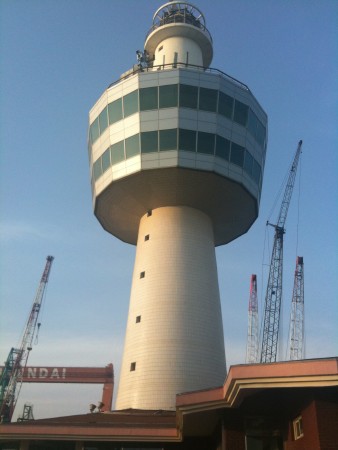
1994 (station established 1983). Active; focal plane 49 m (161 ft); flash every 10 s, alternately red and white. 44.5 m (146 ft) round concrete tower with lantern and gallery, surrounded about halfway up by a large 2-story observation and exhibition structure. Lighthouse painted white; the observation platform is silvery metallic. This station includes the harbor control office for Ulsan. A photo is at right, Kim Son Lego has a 2020 photo, a 2018 photo is available, JunPhy Gu has a closeup, and Google has a satellite view. This lighthouse was originally 30 m (98 ft) in height. The observation platform was added in 1997 and in 2002 the tower was raised 14.5 m (48 ft) to its present height, making it Korea's tallest lighthouse. No information is available on the schedule for the observation deck. Located at the tip of a blunt peninsula sheltering the east side of the harbor of Ulsan. Site open, observation deck presumably open. ARLHS SKR-011; KR-1361; Admiralty M4385; NGA 16688.
Hwaambudu (Hwaamchu Breakwater) (2?)
Date unknown. Active; focal plane 17 m (56 ft); yellow flash every 4 s. This was an 11 m (43 ft) round cylindrical concrete tower, painted yellow; Kim Cheol Bong has a photo and Google has a satellite view. Located at the end of a short breakwater at the tip of the peninsula below the Hwaamchu tower. Site status unknown. KR-1383.5; Admiralty M4381.38; NGA 16691.5.
Ulsan Outer Breakwater East End
Date unknown. Active; focal plane 17 m (56 ft); yellow flash every 4 s. 10 m (33 ft) round cylindrical concrete tower, painted yellow. Kim Cheol Bong has a photo and Google has a satellite view. Located at the east end of a detached outer breakwater protecting the entrance to the bay of Ulsan. Accessible only by boat, but there must be a good view from the Hwaamchu lighthouse, which is about 800 m (1/2 mi) northeast. Site and tower closed. KR-1363; Admiralty M4381.3; NGA 16690.

Hwaamchu Light
Hwaamchu Light, Nam-gu, Ulsan, March 2011
ex-Panoramio photo copyright 민_min; used by permission

Ulsan Outer Breakwater West End (2)
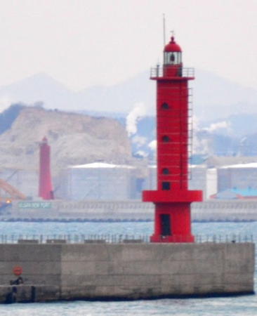
Date unknown. Active; focal plane 21 m (69 ft); red flash every 8 s. 15 m (49 ft) round cylindrical concrete tower with lantern and gallery, painted red. Kim Cheol Bong's photo is at right, Lightphotos.net has a 2012 photo also showing the Hwaamchu lighthouse, and Google has a satellite view. Located at the west end of a detached outer breakwater protecting the entrance to the bay of Ulsan. Accessible only by boat, but there must be a good view from the Hwaamchu lighthouse, which is about 1.2 km (3/4 mi) northeast. Site and tower closed. KR-1364; Admiralty M4381.36; NGA 16691.
Ulsan Yangjuk Breakwater (2)
2012 (station establishment date unknown). Active; focal plane 19 m (62 ft); green flash every 6 s. 16 m (52 ft) round cylindrical white concrete tower with double gallery. Yanghun Lee has a photo and Google has a satellite view. According to Yanghun this is the historic Jangsaeng fishery harbor, formerly the base for the Korean whaling fleet. NGA formerly listed a shorter tower at this location, and it's possible that the present tower is an extension of the original tower. Located at the end of a breakwater on the west side of the the inner harbor of Ulsan. Site and tower closed. KR-1369; Admiralty M4382; NGA 16700.
* Ulsan Maeam Breakwater
Date unknown. Active; focal plane 17 m (56 ft); green flash every 4 s. 13 m (43 ft) round cylindrical white concrete tower. No photo available but Google has a satellite view. Located at the end of a breakwater on the west side of the entrance to the inner harbor of Ulsan.; this location is adjacent to the city's Whale Museum. Appears accessible by walking the pier. Site open, tower closed. Admiralty M4381.8; NGA 16699.5.
Ulsan Namhwa Wharf
Date unknown. Active; focal plane 11 m (36 ft); three yellow flashes every 7 s. 8 m (26 ft) round cylindrical yellow concrete tower. No photo available but Google has a satellite view. Located at the end of a pier at an oil terminal on the west side of the entrance to the harbor of Ulsan. Site and tower closed. KR-1396.5; Admiralty M4381.6; NGA 16696.1.
Ulsan Namhwa Breakwater
Date unknown. Active; focal plane about 15 m (49 ft); green light, characteristic unknown. Approx. 12 m (39 ft) round cylindrical white concrete tower. No photo available but Google has a satellite view. Located at the end of a breakwater on the west side of the entrance to the harbor of Ulsan. Site and tower closed. Admiralty M4381.42.
Onsan Hang Detached Breakwater North Head
Date unknown. Active; focal plane 31 m (102 ft); green flash every 4 s. 29 m (95 ft) round concrete tower. Entire lighthouse is white. No photo available but Google has a satellite view. Located at the north end of the long detached breakwater between the Ulsan and Onsan harbors. Accessible only by boat. Site status unknown. KR-1430.24; Admiralty M4381.21; NGA 16711.84.

Outer Breakwater West End Light, Ulsan, March 2014
(Onsan Hang Detached Breakwater South End Light in the background)
ex-Panoramio photo copyright Kim Cheol Bong; used by permission
Onsan Hang Detached Breakwater South Head
Date unknown. Active; focal plane 31 m (102 ft); two yellow flashes every 4 s. 29 m (95 ft) round concrete tower with lantern and gallery. Entire lighthouse is red. This tower is in the left background of Kim Cheol Bong's photo of the Ulsan Outer Breakwater Light (above right), and Google has a satellite view. Located at the south end of the long detached breakwater between the Ulsan and Onsan harbors. Accessible only by boat. Site status unknown. Admiralty M4381.19; NGA 16705.
#Onsan Hang North Breakwater
Date unknown. Removed in 2016. This was a 10 m (33 ft) round concrete tower, painted red. No photo available and Google's satellite view confirms the removal of the tower. The light was removed when the breakwater was shortened. Located at the end of the breakwater on the north side of the entrance to Onsan harbor on the south side of Ulsan. Site and tower closed. ex-Admiralty M4379; ex-NGA 16704.

Ulju County: Ulsan Sin Hang (New Harbor) Lighthouses
Onsan Hang South Breakwater North Elbow (2)
Date unknown. Active; focal plane 22 m (72 ft); green flash every 6 s. 17 m (56 ft) round cylindrical white concrete tower. Google has a satellite view. NGA formerly listed the original light, a shorter tower with a focal plane of 14 m (43 ft). Located at the end of the original breakwater on the south side of the entrance to Onsan harbor on the south side of Ulsan (the breakwater has been extended southeastward). Site and tower closed. KR-1406; Admiralty M4379.2; NGA 16708.
Onsan Hang South Breakwater East End
Date unknown. Active; focal plane 17 m (56 ft); yellow flash every 4 s. 13 m (43 ft) round concrete tower with lantern and gallery, painted yellow. Google has a satellite view. This light and the next one frame the north entrance to the Ulsan Sin Hang (Ulsan New Port), which was completed in 2011. Located at the end of an eastward extension of the Onsan Hang South Breakwater. Site and tower closed. KR-1430.5; Admiralty M4381.12; NGA 16706.
Ulsan Sin Hang East Breakwater North Head
2010(?). Active; focal plane 31 m (102 ft); green (?) flash every 4 s. Approx. 25 m (82 ft) slanted concrete tower with lantern. Entire lighthouse is white. Google has a satellite view. This light and the previous one frame the north entrance to the Ulsan Sin Hang (Ulsan New Port). Located at the north end of the detached main (east) breakwater of Ulsan Sin Hang. Accessible only by boat. Site and tower closed. KR-1430.12; Admiralty M4381.14; NGA 16711.6.
Ulsan Sin Hang East Breakwater South End
2009. Active; focal plane 31 m (102 ft); two red flashes every 6 s. Approx. 25 m (82 ft) slanted concrete tower with lantern, gallery, and a lower observation gallery. Lighthouse painted red with two narrow white horizontal bands. The light is at the far left of the photo at right and Google has a satellite view. Located at the south end of the detached main (east) breakwater of Ulsan Sin Hang. Accessible only by boat, but apparently boat tours are available since several photos show visitors on the observation gallery. Site open, observation gallery open. KR-1430.13; Admiralty M4381.16; NGA 16711.65.
Ulsan Sin Hang South Breakwater East End
2009. Active; focal plane 31 m (102 ft); two green flashes every 6 s. Approx. 25 m (82 ft) slanted concrete tower with lantern, gallery, and a lower observation gallery. Lighthouse painted white with two narrow red horizontal bands. A Coast Guard photo is at right, another photo is available, and Google has a satellite view. So far no photos have been seen showing visitors on the observation gallery, but presumably the tower is or eventually will be open to visitors. Located at the end of the south breakwater of Ulsan Sin Hang. Site status unknown. Admiralty M4381.18; NGA 16711.8.
Ulsan Sin Hang east Breakwater South End Light
Sin Hang East Breakwater (left) and South Breakwater Lights, Ulsan
Ulsan Maritime Affairs and Port Administration photo
Ulsan Sin Hang Outer Breakwater North Head
Date unknown. Active; focal plane 20 m (66 ft); four yellow flashes every 8 s. 8.5 m (28 ft) (?) round steel tower painted yellow. No photo available but Bing has a satellite view. Located at the end of a new outer breakwater beginning outside the south end of the older East Breakwater. Accessible only by boat. Site and tower closed. KR1434.3; Admiralty M4381.15; NGA 16711.66.
Ulsan Sin Hang Outer Breakwater Middle
Date unknown. Active; focal plane 17 m (56 ft); four yellow flashes every 8 s. 6 m (20 ft) (?) round steel tower painted yellow. No photo available and the tower is not shown in Bing's satellite view. Located on the new outer breakwater. Accessible only by boat. Site and tower closed. Admiralty M4381.151; NGA 16711.67.
Nambang Pahoan
2022. Active; focal plane 19 m (62 ft); three green flashes every 7 s. 18 m (59 ft) square white concrete tower. No photo available but Google has an indistinct satellite view. Located at the elbow of a breakwater for a new harbor being developed south of Ulsan. Site and tower closed. KR-1430.11; Admiralty M4378.35.
Gangyang
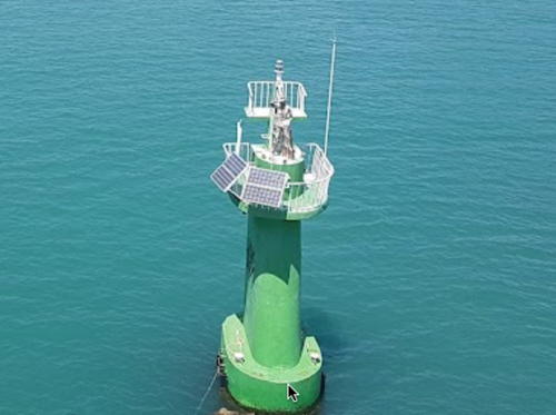
Date unknown. Active; focal plane 10 m (33 ft); green flash every 5 s. 11 m (36 ft) solid concrete pillar with gallery, painted green. Lee Jaeyong has an overhead view (a portion is seen at right), Ki Kyun Park has a photo, and Google has a satellite view. This is one of very few Korean lights painted green. Located in the Hoeya River entrance at Gangyang, almost directly under a new pedestrian bridge. Accessible only by boat. Site open, tower closed. Admiralty M4378.2; NGA 16711.9.
 

Gangyang Light, Ulsan, April 2017
Google photo by Lee Jaeyong
 

Ulju County: Ganjeolgot Area Lighthouses
* Songjeong Hang
Date unknown. Active; focal plane 12 m (39 ft); two red flashes every 6 s. 9 m (30 ft) round cylindrical concrete tower with an expanded base. Entire lighthouse is red. Choi Yeung Cheol has a photo and Google has a satellite view. Located on the north breakwater of Songjeong harbor, on the north side of the Ganjeolot peninsula. Accessible by walking the pier. Site open, tower closed. KR-1438.8; Admiralty M4378.05; NGA 16711.94.
* Daesong Hang
2010. Active; focal plane 12 m (39 ft); two red flashes every 6 s. 9 m (30 ft) round cylindrical concrete tower with an expanded base. Entire lighthouse is red. K. McCartan has a photo, Choi Yeung Cheol has a photo, and Google has a street view and a satellite view. Located at the end of the Daesong breakwater, on the north side of the Ganjeolot peninsula. Accessible by walking the pier. Site open, tower closed. KR-1438.9; Admiralty M4378.03; NGA 16711.95.
* Ganjeolgot (Cape Kanjol) (1)
1920. Inactive since 2001. 5 m (17 ft) lantern and gallery on an octagonal base, painted white. The aerobeacon light is mounted in the lantern. A 2019 street view is available and Google has a satellite view. Located just to the south of the present lighthouse. Site open and gallery open.
** Ganjeolgot (Cape Kanjol) (2)
2001. Active; focal plane 35 m (115 ft); white flash every 15 s. 17 m (56 ft) octagonal cylindrical concrete tower with lantern and gallery. Lighthouse painted white; lantern roof is gray. Fog horn (blast every 55 s). A photo is at right, a 2019 photo is available, No Yong Seon has a 2016 photo and a street view, and Google has a satellite view. This is a staffed station. The lighthouse, office, and keeper's quarters were all rebuilt in 2001. Standing at the southeastern corner of Korea, Gangeolgot is celebrated as the first point of the country to see the rising sun. The light station is located in a park area that includes a small museum and a sculpture garden. Located on a promontory about 25 km (15 mi) south of downtown Ulsan. Site open, museum open daily, tower closed. . ARLHS SKR-012; KR-1439; Admiralty M4378; NGA 16712.
* Pyeongdong Hang
2016. Active; focal plane 12 m (39 ft); red flash every 4 s. 8 m (26 ft) round cylindrical conctete tower. Entire lighthouse is red. Steve Cardoctor has a drone view (light in upper left corner), a 2019 view across the harbor is available and Google has a satellite view. Located on the breakwater of a small boat harbor about 800 m (1/2 mi) southwest of Ganjeolgot. Accessible by walking the pier. Site open, tower closed. KR-1439.20; Admiralty M4377.95.
Ganjeolgot Light
Ganjeolgot Light, Ulsan, June 2012
Ulsan Maritime Affairs and Port Administration photo
* Nasa
Date unknown. Active; focal plane 19 m (62 ft); white flash every 6 s. 12 m (39 ft) round white concrete tower with upper and lower galleries. Gang In-ho has the closeup street view seen at right and Google has a satellite view. Visitors can enjoy the view from the lower gallery. Located on a sharp promontory on the east side of the harbor of Nasa, a small port on the south side of the Ganjeolot peninsula. Parking provided. Site open, tower closed. . KR-1439.1; Admiralty M4377.9; NGA 16713.
* Nasa East Breakwater
Date unknown. Active; focal plane about 18 m (59 ft); light characteristic unknown. Approx. 15 m (49 ft) round red concrete tower with lantern and gallery. Junho Lee has a 2023 closeup, the tower is at the left in a 2018 photo and Google has a street view and a satellite view. Located on the main breakwater at Nasa. Site presumably open, tower closed. KR-1439.21; Admiralty M4377.89.
* Nasa West Breakwater
Date unknown. Active; focal plane about 18 m (59 ft); light characteristic unknown. Approx. 15 m (49 ft) round white concrete tower with lantern and gallery. A 2021 closeup photo is available, the tower is at the right in a 2018 photo, Lee Hyun Keun's distant view shows the lighthouse floodlit at night, and Google has a satellite view. Located on the inner breakwater at Nasa. Site presumably open, tower closed. . KR-1438.13; Admiralty M4377.88.
* Sinam Hang (2)
2020. Active; focal plane 13 m (43 ft); two green flashes every 6 s. 8 m (26 ftd) vase-shaped octagonal steel tower painted white. A 2021 view across the harbor is available and Google has a satellite view. Lee Sang-cheon has a 2019 photo of the previous light. Located on the west breakwater of Sinam harbor. Site presumably open, tower closed. KR-1439.3; Admiralty M4377.84.

Nasa Light, Ulgu County, May 2017
Google street view by Gang In-ho
* Silli Hang
Date unknown. Active; focal plane about 13 m (43 ft); two green flashes every 6 s. Approx. 10 m (33 ft) round white concrete tower. Kim Dong Yeong has a photo and Google has a street view and a satellite view. Located on the south breakwater of Silli harbor. Site open, tower closed. Admiralty M4377.8.
* Gori (Kori) Hang
Date unknown. Active; focal plane about 13 m (43 ft); red light, pattern unknown. Approx. 10 m (33 ft) round red concrete tower. No photo available but Google has a satellite view. Located on the breakwater of Gori harbor adjacent to the Gori (Kori) Nuclear Power Plant at the southern edge of Ulsan City. Site open, tower closed. KR-1439.31; Admiralty M4377.79.

Information available on lost lighthouses:

Notable faux lighthouses:

Adjoining pages: North: Gyeongju | South: Northern Busan

Return to the Lighthouse Directory index | Ratings key

Posted October 29, 2007. Checked and revised November 17, 2023. Lighthouses: 49. Site copyright 2023 Russ Rowlett and the University of North Carolina at Chapel Hill.