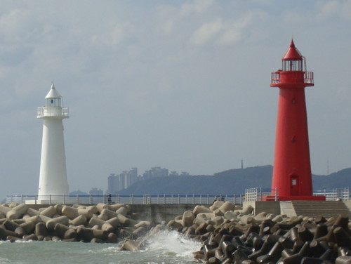
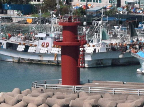
Lighthouses of South Korea: Northern Busan

For most of its history Korea was an independent kingdom, or at least an autonomous kingdom under Chinese influence. This came to an end in 1910 when Japan annexed all of Korea. At the end of World War II in 1945 the 38° parallel was established as the dividing line between U.S. and Soviet zones of occupation, and in 1948 separate civil administrations were established in the two halves of the country. The Korean War (1950-53) ended in a draw with the armistice line falling close to the prewar 38° line. The Republic of Korea (ROK), commonly called South Korea, occupies the Korean peninsula south of the armistice line.

South Korea is divided into nine provinces and eight province-level cities. This page covers lighthouses of the northern half of the metropolitan (province-level) city of Busan on South Korea's southeast coast. With a population of more than 3.5 million, Busan (formerly spelled Pusan) is Korea's second largest city and largest port. The city faces the Korea Strait, which connects the East Sea (commonly called the Sea of Japan in the West) to the East China Sea. It stands on an intricate and rocky coast with numerous islands of all sizes offshore.

The Busan metropolitan area has an extraordinary number of lighthouses, nearly 100 in all. This page includes the lighthouses of the northern sections of the area, including Gijang County and the urban districts of Haeundae and Suyeong. The northern suburbs have some of the most unusual lighthouses in the world; several are pictured on this page.

In 2000 South Korea adopted a Revised Romanization System to replace systems formerly used in the West. In the Revised System, the word for a lighthouse is deungdae (등대); dan (formerly tan) is a cape, seom (som) or do (to) is an island, am or amseog is a rock, man is a bay, and hang is a harbor. Some place names may be more familiar to Westerners in the spellings of older systems.

The name Korea, used internationally, is a Western version of Goryeo or Koryŏ (고려), the name of a kingdom that unified the country in the tenth century. From 1392 to 1897 the kingdom was known instead as Joseon or Chosŏn (조선). Today South Koreans usually call their country Hanguk (한국, literally "one country") and the official name of the Republic of Korea is Daehan Minguk (대한민국).

Navigational aids in the ROK are regulated by the Ministry of Oceans and Fisheries (MOF). Management of lighthouses in Busan is the responsibility of the Busan Regional Oceans and Fisheries Administration. The Korean Hydrographic and Oceanographic Administration (KHOA) publishes notices to mariners.

ARLHS numbers are from the ARLHS World List of Lights. KR numbers, where available, are from the Korean light list. Admiralty numbers are from volume M of the Admiralty List of Lights & Fog Signals. U.S. NGA List numbers are from Publication 112.

General Sources
Aids to Navigation - Lighthouse
Information in English posted by Busan MOF concerning Busan's major lighthouses of Yeongdo and Gadeokdo.
Lighthouses in South Korea
Photos by various photographers available from Wikimedia.
World of Lighthouses - South Korea
Photos by various photographers available from Lightphotos.net.
Online List of Lights - Korea
Photos by various photographers posted by Alexander Trabas. Photos for this area are by Jim Smith.
Navionics Charts
Navigational chart of the Busan area.


Suyeongman Light, Haeundae, July 2013
Google Maps photo by Joseph Hollick
Gijang County Lighthouses

Jangan Town Lighthouses
Hyoam (Singori) Breakwater
Date unknown. Active; focal plane 21 m (69 ft); red flash every 4 s. 16 m (52 ft) round tapered red concrete tower with lantern and gallery. No photo available but Google has a satellite view. Located on a breakwater, just inside the Busan city limit, of the Gori (Kori) Nuclear Power Plant. Site and tower closed. KR-1439.23; Admiralty M4377.77.
* Wollae-ri (Wolnae-ri) North Breakwater
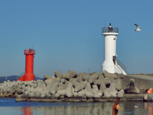
2008. Active; focal plane 16 m (52 ft); red flash every 5 s. 11 m (36 ft) octagonal concrete tower, painted red. Sang Yun Shin has a photo (also seen at right), Yujin Woo has a photo showing both breakwater lighthouses, Sang-il Seok has a 2022 photo showing both lighthouses, and Google has a street view and a satellite view. Located on the north breakwater at Wollae-ri, a small harbor near the northern border of the Busan metropolitan region. Accessible by walking the breakwater. Site open, tower closed. KR-1439.24; Admiralty M4377.62.
* Wollae-ri (Wolnae-ri) South Breakwater
Date unknown. Active; focal plane 11 m (36 ft); green flash every 5 s. 10 m (33 ft) round cylindrical white concrete tower with a stairway at the base. Sang-il Seok has a 2022 sunset photo of this lighthoaue and a photo showing both lighthouses, Yujin Woo has a photo showing both breakwater lighthouses, and Google has a street view and a satellite view. Located on the south breakwater at Wollae-ri. Accessible by walking the breakwater. Site open, tower closed. KR-1439.4; Admiralty M4377.6; NGA 16714.


Wollae-ri North Breakwater Light, Busan, September 2017
Google Maps photo by Sang Yun Shin


Ilgwan Township Lighthouses
* Imrang Hang Breakwater
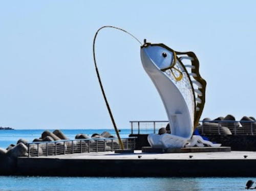
Date unknown. Active; focal plane 8 m (26 ft); green flash every 3 s. 8 m (26 ft) sculpture of a leaping fish caught on an angler's line; the light is atop the fish's nose. Really. Park Young-min has the photo seen at right, a 2021 closeup is available, Noh Yong-sun has a street view and Google has an indistinct satellite view. Located on the breakwater of Imrang harbor. Accessible by walking the breakwater. Site open, tower closed. KR-1439.14; Admiralty M4377.58.
* Munjung Hang North Breakwater (2)
2013. Active; focal plane 14 m (46 ft); red flashing light, two red flashes every 6 s. 10 m (33 ft) round cylindrical concrete tower with gallery, painted red. A small 2022 photo is available and Google has a street view and a satellite view. Located at the end of the north breakwater of Munjung harbor, about 5 km (3 mi) north of Hakri Hang. Accessible by walking the breakwater. Site open, tower closed. KR-1439.11; Admiralty M4377.56.
* Munjung Hang South Breakwater
2002. Active; focal plane 14 m (46 ft); two green flashes every 5 s. 12 m (39 ft) round white barbell-shaped concrete tower with gallery. Sang-won Lee has a closeup photo, several additional photos are available, and Google has a street view and a satellite view. Located at the end of the south breakwater of Munjung harbor. Accessible by walking the breakwater. Site open, tower closed. KR-1440; Admiralty M4377.55.

Imrang Hang Light, Busan, April 2019
Google Maps photo by Park Young-min
Chiram Detached Breakwater North End ("Sea Eel Lighthouse")
2014. Active; focal plane about 11 m (36 ft); green light, pattern unknown. Approx. 8 m (26 ft) round cylindrical concrete tower built with two spiralling strands weaving together. Entire lighthouse is brown. A 2022 photo is available and Google has a street view and an indistinct satellite view. Located at the north end of a short detached breakwater at Chiram. Accessible only by boat. Site open, tower closed. Admiralty M4377.542.
Chiram Detached Breakwater South End ("Seagull Lighthouse)
2014. Active; focal plane about 11 m (36 ft); red flash every 4 s. Approx. 8 m (26 ft) slender round cylindrical concrete tower, painted red. Next to the tower is a large red ring-shaped sculpture with two seagulls shown flying within the ring. Dong Wook Bang has a 2021 photo, a view from shore and a 2022 photo are available, and Google has a street view and an indistinct satellite view. Located at the south end of a short detached breakwater at Chiram. Accessible only by boat. Site open, tower closed. KR-1439.32; Admiralty M4377.541.
* Chiram Hang ("Baseball Lighthouse")
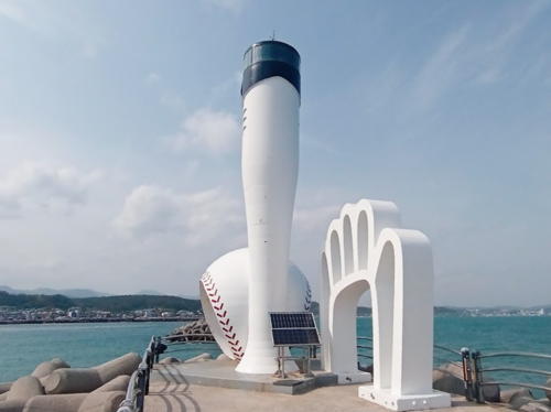
2011. Active; focal plane about 11 m (36 ft); green flash every 4 s. Approx. 8 m (26 ft) round tower shaped like a baseball bat. Next to the tower are sculptures of a baseball and a baseball glove. Geun-ho Cho's photo is at right, Shin Hae-in has a 2022 photo, a 2017 photo is available, and Google has an indistinct satellite view. Located at the end of the south breakwater at Chiram. Accessible by walking the breakwater. Site open, tower closed. KR-1440.6; Admiralty M4377.54.
Sinpyeong Hang South Breakwater
2003. Active; focal plane 14 m (46 ft); red flash every 5 s. 11 m (36 ft) round barbell-shaped concrete tower with gallery, painted red. A 2019 photo is available and Google has a street view and a satellite view. Located at the south end of a detached breakwater about 1 km (0.6 mi) south of Munjung Hang. Accessible only by boat. Site open, tower closed. KR-1439.9, Admiralty M4377.53; NGA 16716.1.

Chiram Hang "Baseball" Light, Busan, May 2021
Google Maps photo by Geun-ho Cho
* Dongbaek Hang North Breakwater
Date unknown. Active; focal plane 11 m (36 ft); red flash every 5 s. 10 m (33 ft) round cylindrical concrete tower with gallery, painted red. Jang Hyo Won has the photo at right and Google has a street view and a satellite view. The Admiralty renumbered the Dongbaek lights in September 2022. Located at the end of the north breakwater of Dongbaek harbor. Accessible by walking the breakwater. Site open, tower closed. KR-1439.6; Admiralty M4377.527 (ex-M4377.7); NGA 16716.2.
* Dongbaek Hang South Breakwater
Date unknown. Active; focal plane 12 m (39 ft); green flash every 5 s. 10 m (33 ft) round cylindrical concrete tower with gallery, painted white. Jang Hyo Won's photo is at right and Google has a street view and a satellite view. Located at the end of the south breakwater of Dongbaek harbor. Accessible by walking the breakwater. Site open, tower closed. KR-1439.7; Admiralty M4377.526 (ex-M4377.73).
* I-dong Hang North Breakwater
Date unknown. Active; focal plane 15 m (49 ft); two red flashes every 6s. 12 m (39 ft) round barbell-shaped concrete tower with gallery, painted red. A 2023 photo is available and Google has a street view and a satellite view. Located at the end of the north breakwater of I-dong harbor. Accessible by walking the breakwater. Site open, tower closed. KR-1440.1; Admiralty M4377.525.
* I-dong Hang
2013. Active; focal plane 10 m (33 ft); two green flashes every 6s. 10 m (39 ft) round cylindrical concrete tower with gallery, painted green. Jaeik Kim has a 2018 view from shore and Google has a street view and satellite view. Located on the south side of the entrance to I-dong harbor, either on a natural reef or on a new breakwater. Site open, tower closed. KR-1440.8; Admiralty M4377.524.
Dongbaek Hang Breakwater Lights
Dongbaek Hang Breakwater Lights, Gijang, December 2011
ex-Panoramio photo copyright Jang Hyo Won; used by permission
#Icheon Hang
Date unknown. Removed in 2021. This was an approx. 10 m (33 ft) round cylindrical concrete tower, painted red. Google has a 2017 street view and a satellite view. The light was removed when the breakwater was extended by about 100 m (330 ft). A 2023 photo shows a red post light at the end of the extension. Located at the end of the central breakwater at Icheon. Accessible by walking the breakwater. Site open, tower closed. KR-1440.2; ex-Admiralty M4377.52.
Hangni (Hakri) Hang West Breakwater (2?)
Date unknown. Active; focal plane 15 m (49 ft); two red flashes every 5 s. 14 m (46 ft) round cylindrical concrete tower with lantern and gallery. Entire lighthouse is red. Seungpyo Hong's photo is at right, Kim Hyung Jun has a photo, Park Young-min has a 2019 photo of this light and the next two, and Google has a street view and a satellite view. Located at the end of the breakwater on the south side of the entrance to Hakri, a harbor about 20 km (13 mi) northeast of downtown Busan. Site status unknown. KR-1439.16; Admiralty M4376.9.
Hangni (Hakri) Hang East Breakwater (2)
Date unknown. Active; focal plane 15 m (49 ft); two green flashes every 5 s. 14 m (46 ft) round cylindrical concrete tower with lantern and gallery. Entire lighthouse is white. Seungpyo Hong's photo is at right, Park Young-min has a 2019 photo and Google has a street view and a satellite view. The original lighthouse was a plain cylindrical white tower. Located at the end of the breakwater on the south side of the entrance to Hakri, a harbor about 20 km (13 mi) northeast of downtown Busan. Site status unknown. KR-1439.15; Admiralty M4377.1; NGA 16718.
#Hangni (Hakri) Hang East Breakwater Elbow
Date unknown. Apparently removed. This was an approx. 10 m (33 ft) round cylindrical concrete tower. Entire lighthouse was yellow. Google has a 2017 street view and Park Young-min has a 2019 closeup photo but the tower is not seen in Google's satellite view. Located about 60 m (200 ft) east of the East Breakwater Light (previous entry). Site status unknown.
Hangni (Hakri) Hang
Date unknown. Active; focal plane 11 m (36 ft); two white flashes every 10 s. 11 m (36 ft) round cylindrical concrete tower with gallery, painted black with one red horizontal band. No photo available but Google has an indistinct satellite view. Located at the end of a reef projecting into the East Sea just south of Hangni. Site open, tower closed. KR-1439.10; Admiralty M4377.51.

Hangni Hang East (left) and West Breakwater Lights, Busan, May 2020
Google Maps photo by Seungpyo Hong

Gijang Town Lighthouses
Jukseong (Duho) Breakwater
2004. Active; focal plane 14 m (46 ft); green flash every 5 s. 12 m (39 ft) octagonal cylindrical concrete tower with gallery, painted white. Jinyoung Kim has a 2020 photo, a closeup is available, and Google has a street view and a satellite view. Located at the end of the breakwater of the fishing harbor at Jukseong, a town about 18 km (12 mi) northeast of downtown Busan. Accessible by walking the breakwater. Site open, tower closed. KR-1440.3; Admiralty M4376.58.
Duho Hang
Date unknown. Active; focal plane 18 m (59 ft); green flash every 4 s. 12 m (39 ft) round cylindrical concrete tower with double gallery, mounted on a round concrete pier. Entire structure painted green. Google has a street view and a satellite view. This real lighthouse is offshore from the well-known Jukseong faux lighthouse. Located on a reef about 1.6 km (1 mi) east of Jukseong. Accessible only by boat. Site open, tower closed. KR-1440.4; Admiralty M4376.6; NGA 16718.5.
* Woljeon Hang
2010. Active; focal plane 12 m (39 ft); red flash every 4 s. 11 m (36 ft) square cylindrical hollow concrete tower with jagged sections missing along two edges. Outside of the tower painted red. Park Soo-hyun has a 2022 photo, Chu Young-cheol has a 2023 photo, and Google has a street view and a satellite view. Located on the main breakwater of Woljeon village. Accessible by walking the pier. Site open, tower closed. KR-1440.5; Admiralty M4376.4; NGA 16718.6.
Gwanggyemal
Date unknown. Active; focal plane 22 m (72 ft); white flash every 6 s. 13 m (43 ft) octagonal cylindrical concrete tower with gallery, painted white. Google has a street view and a satellite view. Located on a promontory just south of Woljeon. Site status unknown. KR-1440.7; Admiralty M4376.3; NGA 16719.
* Daebyeon (Taebyon) Hang East Breakwater ("World Cup Lighthouse")
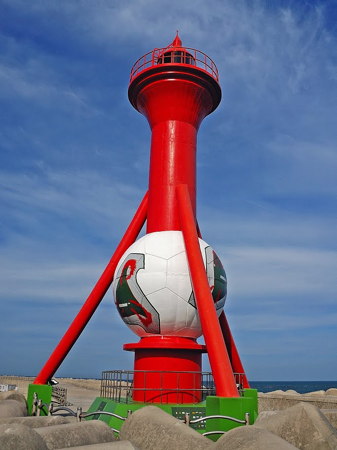
Around 2000. Active; focal plane 22 m (72 ft); two red flashes every 10 s. 17 m (56 ft) round cylindrical concrete tower with lantern, gallery, and unusual tripod supports, painted red; the spherical white structure around the lower part of the tower is a soccer ball recognizing the 2002 FIFA World Cup, held in South Korea and Japan with Busan as one of the venues. A closeup photo is at right, Cheolhoon An has a 2020 photo, Jinseung Lee has another closeup of this unusual light, and Google has a satellite view and a distant street view. Located at the end of the outer breakwater at Daebyeon, an important fishing harbor about 16 km (10 mi) east northeast of Busan. Accessible by walking the breakwater. Site open, tower closed. KR-1441; Admiralty M4375.9; NGA 16721.

Daebyeon Hang East Breakwater Light, Gijang, April 2015
ex-Panoramio photo copyright Yun Gu Ho; permission requested
* Daebyeon (Taebyon) Hang Inner Breakwater
Date unknown. Active; focal plane 17 m (56 ft); red flash every 5 s. 13 m (43 ft) round cylindrical concrete tower with lantern and gallery, painted red. Oh Jong-woo has a video with a view from the harbor and Google has a satellite view. Located at the end of the breakwater; accessible by walking the pier. Site open, tower closed. KR-1442; Admiralty M4376; NGA 16720.
Daebyeon (Taebyon) Hang South Breakwater East End
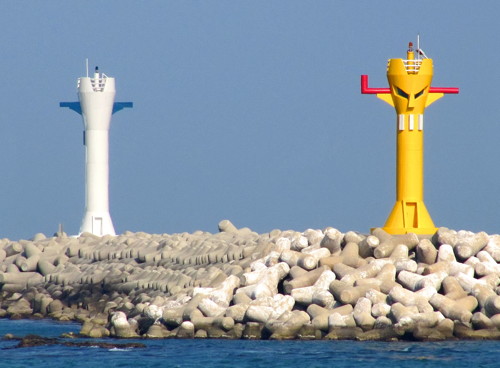
Date unknown. Active; focal plane 23 m (75 ft); green flash every 5 s. 17 m (56 ft) round cylindrical concrete tower with gallery, painted white. The light is decorated with dark blue "ears" and markings suggesting a face. Lee Iljoo's photo is at right, there's a distant view, and Google has a satellite view and a very distant street view of the two lights. Located at the east end of a short detached breakwater just south of the east breakwater light. Accessible only by boat. Site open, tower closed. KR-1442.10; Admiralty M4375.95; NGA 16722.5.
Daebyeon (Taebyon) Hang South Breakwater West End
Date unknown. Active; focal plane 19 m (62 ft); yellow flash every 5 s. 13 m (43 ft) round cylindrical concrete tower with gallery, painted yellow. The light is decorated with red "ears" and markings suggesting a face. Lee Iljoo's photo is at right and Google has a satellite view. Accessible only by boat. Site open, tower closed. KR-1442.11; Admiralty M4375.98; NGA 16723.
* Seoam North Breakwater
2010. Active; focal plane 4 m (13 ft); red flash every 6 s. 4 m (13 ft) platform with stairs and staircase sides upswept like the prow of a ship. Sides of the structure painted red. Kyupill Hwang has a 2021 closeup photo, Kim Cheol Bong has a photo, and Google has a street view and a distant satellite view. Located on the north breakwater of Seoam harbor, just south of the Daebyeon harbor. Accessible by walking the pier. Site open, tower closed. Admiralty M4376.01.
Daebyeon Hang South Breakwater Lights
Daebyeon Hang South Breakwater Lights, Gijang, May 2009
ex-Panoramio photo copyright Lee Iljoo; used by permission
* Seoam South Breakwater ("Baby Bottle Lighthouse")
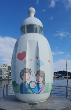
2010. Active; focal plane 4 m (13 ft); red flash every 6 s. 4 m (13 ft) round concrete tower, shaped like a baby's bottle. Hyun Jo Park has a closeup 2022 photo (seen at right), Kim Boman has a closeup street view, Cheol Hwan Kim has a photo, and Google has a distant satellite view. Located on the south breakwater of Seoam harbor. Accessible by walking the pier. Site open, tower closed. KR-1442.1; Admiralty M4376.02.
* Dongameo Hang North Breakwater
2007. Active; focal plane 12 m (39 ft); red flash every 4 s. 11 m (36 ft) round cylindrical concrete tower with gallery, painted red. Trabas has Smith's photo and Google has a street view and a satellite view. Located at the end of the north breakwater at Dongameo. Accessible by walking the breakwater. Site open, tower closed but an observation platform is accessible by stairs. KR-1443; Admiralty M4375.81.

Haeundae District Lighthouses

* Gongsu Hang
2013. Active; focal plane 12 m (39 ft); red flash every 6 s. 10 m (33 ft) round concrete tower, painted red. Cu Young Chun has a photo and Google has a street view and a satellite view. Located on the main breakwater of Gongsu harbor, a short distance east of Songjeong. Site open, tower closed. KR-1443.1; Admiralty M4375.74.
* Songjeong North Breakwater
Date unknown. Active; focal plane 10 m (33 ft); red flash every 5 s. 10 m (33 ft) round cylindrical concrete tower with gallery, painted red. Trabas has Jim Smith's photo, Marjorie Ordillas has a closeup and a photo of both breakwater lights, and Google has a street view and a satellite view. Located at the end of the north breakwater at Songjeong. Accessible by walking the breakwater. Site open, tower closed. KR-1443.2; Admiralty M4375.7; NGA 16723.5.
* Songjeong South Breakwater
Date unknown. Active; focal plane 10 m (33 ft); green flash every 5 s. 10 m (33 ft) round cylindrical concrete tower with gallery, painted white. Trabas has Jim Smith's photo, Marjorie Ordillas has a photo of both breakwater lights and Google has a street view and a satellite view. Located at the end of the south breakwater at Songjeong. Accessible by walking the breakwater. Site open, tower closed. KR-1443.3; Admiralty M4375.71; NGA 16723.51.

Seoam South Breakwater Light, November 2022
Google Maps photo by Hyun Jo Park
Songjeongri (Songjungri, Songjeong-ni)
Date unknown. Active; focal plane 16 m (52 ft); three quick white flashes every 10 s. 15 m (49 ft) round tower, painted black with one yellow horizontal band. No closeup photo available. The lighthouse appears on the horizon of a photo of the Songjeong North Breakwater Light and Google has a satellite view and a very distant street view. Located on an isolated rock about 2.5 km (1.5 mi) offshore and 8 km (5 mi) northeast of the Busan harbor entrance. Accessible only by boat. Site status unknown. KR-1449; Admiralty M4375.6; NGA 16724.
Gyoseokchu (Kyosokchu)
Date unknown. Active; focal plane 20 m (66 ft); three quick white flashes every 5 s. 19 m (62 ft) round cylindrical concrete tower with lantern and gallery, painted black with one yellow horizontal band. Google has an indistinct satellite view and a very distant street view. Located on the outermost of a group of small rocks about 1 km (0.6 mi) offshore from the Haeundae section of the city. Accessible only by boat. Site status unknown. KR-1450; Admiralty M4375.5; NGA 16724.2.
* Cheongsapo (Chongsapo, Haeundae) East Breakwater
2008. Active; focal plane 19 m (62 ft); red flash every 5 s. 17 m (56 ft) round concrete tower, probably with lantern and gallery, painted red. Jens-Olaf Walter's photo is at right, Angela Kung has a 2017 photo of the two Cheongsapo lighthouses, another 2017 photo is available, and Google has a street view and a satellite view. Located on the west breakwater at Cheongsapo harbor in Haeundae. Accessible by walking the breakwater. Site open, tower closed. KR-1339.1; Admiralty M4375.52; NGA 16724.22.
* Cheongsapo (Chongsapo, Haeundae) West Breakwater
2008. Active; focal plane 19 m (62 ft); green flash every 5 s. 17 m (56 ft) round concrete tower with lantern and gallery, painted white. Jens-Olaf Walter's photo is at right, Angela Kung also has a photo of the two Cheongsapo lighthouses, Kalle Brunö has a photo, and Google has a street view and a satellite view. The lighthouse was relocated when the breakwater was extended in 2022-23; Shiang Yu's October 2023 photo shows the relocation work near completion. Located on the west breakwater at Cheongsapo harbor in Haeundae. Accessible by walking the breakwater. Site open, tower closed. KR-1339.2; Admiralty M4375.53; NGA 16724.21.
Cheongsapo Breakwater Lights
Cheongsapo Breakwater Lights, Haeundae, October 2010
Flickr Creative Commons photo by Jens-Olaf Walter
Suyeongman (Suyeong Man, Mipo)
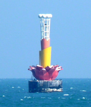
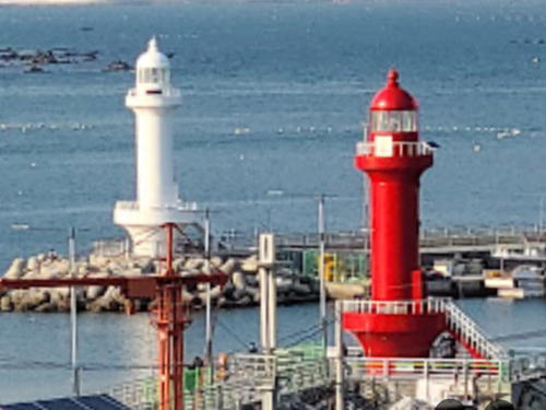
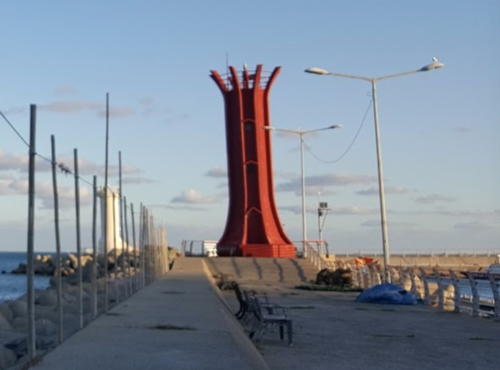
Date unknown (probably 2005). Active; focal plane 28 m (92 ft); two white flashes every 5 s. 20 m (66 ft) tower, shaped to resemble a lotus flower, mounted on a square concrete pier. The lighthouse is red with a yellow band and white "stamens" at the top. Joseph Hollick's photo is at the top of this page, Trabas has Smith's photo and Google has a satellite view and a very distant street view. According to the local tourist agency, this very unusual lighthouse was built to honor the APEC (Asia-Pacific Economic Cooperation) summit meeting held in Busan in 2005. Located on a skerry about 800 m (1/2 mi) south of the Suyeong fishing harbor. Accessible only by boat. Site status unknown. KR-2001.3; Admiralty M4375.55; NGA 16724.3.
Dongbaekseom
Date unknown (around 2013). Active; focal plane about 20 m (66 ft); light characteristic unknown. Approx. 20 m (66 ft) round cylindrical concrete tower with lantern and gallery, upper half painted yellow and lower half black. Google has a distant satellite view and a distant street view from shore. This lighthouse is easy to see from the well-known Haeundae faux lighthouse (see below). Located about 400 m (1/4 mi) offshore from Haeundae Point. Accessible only by boat. Site status unknown. KR-2001.19; Admiralty M4374.35; NGA 16726.4.

Suyeong District Lighthouses

* Millakdong (Millaktong) East Breakwater
Date unknown. Active; focal plane 16 m (52 ft); two red flashes every 6 s. 10 m (33 ft) round cylindrical concrete tower with gallery, painted red. Trabas has Smith's photo, Larry Suen has a closeup photo and a photo of the two lighthouses, a drone view of the two breakwater lighthouses is also available (showing the Gangwan Bridge in the background), and Google has a street view and a satellite view. The Millakdong harbor is a small basin in the Suyeong district on the east side of Busan. Located at the end of the east breakwater. Accessible by walking the breakwater. Site open, tower closed. Admiralty M4374.2; NGA 16727.
* Millakdong (Millaktong) West Breakwater
Date unknown. Active; focal plane 16 m (52 ft); two green flashes every 6 s. 10 m (33 ft) round cylindrical concrete tower with gallery, painted white. Li Wei'an has a closeup photo, Trabas has Smith's photo, a 2018 photo is available, Larry Suen has a photo of the two lighthouses, a drone view of the two breakwater lighthouses is also available, Hyunwook Kim has a distant street view, and Google has a satellite view. Located at the end of the west breakwater of Millakdong. Accessible by walking the breakwater. Site open, tower closed. Admiralty M4374.3; NGA 16727.1.
#Gwangalli (Kwangalli)
Date unknown. Apparently removed in 2018 or 2019. 21 m (69 ft) round metal tower. The light lists describe the tower as being yellow, but Nguyen Huy Tung has a very distant street view in which the tower appears to be white. No closeup photo available. Formerly located about 2.5 km (1.5 mi) off the Suyeong waterfront. Accessible only by boat. Site open, tower closed. ex-Admiralty M4374.1; NGA 16727.5.

Notable faux lighthouses:


Millakdong East Breakwater Light, Suyeong
photo copyright Jim Smith; used by permission

Adjoining pages: North: Ulsan | South: Busan Harbor

Return to the Lighthouse Directory index | Ratings key

Posted December 4, 2007. Checked and revised November 27, 2023. Lighthouses: 42. Site copyright 2023 Russ Rowlett and the University of North Carolina at Chapel Hill.