Lighthouses of South Korea: Busan Harbor

For most of its history Korea was an independent kingdom, or at least an autonomous kingdom under Chinese influence. This came to an end in 1910 when Japan annexed all of Korea. At the end of World War II in 1945 the 38° parallel was established as the dividing line between U.S. and Soviet zones of occupation, and in 1948 separate civil administrations were established in the two halves of the country. The Korean War (1950-53) ended in a draw with the armistice line falling close to the prewar 38° line. The Republic of Korea (ROK), commonly called South Korea, occupies the Korean peninsula south of the armistice line.

South Korea is divided into nine provinces and eight province-level cities. With a population of more than 3.5 million the province-level city of Busan (formerly spelled Pusan) is Korea's second largest city and largest port. The city faces the Korea Strait, which connects the East Sea (commonly called the Sea of Japan in the West) to the East China Sea.

The Busan metropolitan area has an extraordinary number of lighthouses, nearly 100 in all. This page includes the lighthouses of the City's harbor and downtown area. There are separate pages for the northern and southern sections of the metropolitan area.

In 2000 South Korea adopted a Revised Romanization System to replace systems formerly used in the West. In the Revised System, the word for a lighthouse is deungdae (등대); dan (formerly tan) is a cape, seom (som) or do (to) is an island, am or amseog is a rock, man is a bay, and hang is a harbor. Some place names may be more familiar to Westerners in the spellings of older systems.

The name Korea, used internationally, is a Western version of Goryeo or Koryŏ (고려), the name of a kingdom that unified the country in the tenth century. From 1392 to 1897 the kingdom was known instead as Joseon or Chosŏn (조선). Today South Koreans usually call their country Hanguk (한국, literally "one country") and the official name of the Republic of Korea is Daehan Minguk (대한민국).

Navigational aids in the ROK are regulated by the Ministry of Oceans and Fisheries (MOF). Management of lighthouses in Busan is the responsibility of the Busan Regional Oceans and Fisheries Administration. The Korean Hydrographic and Oceanographic Administration (KHOA) publishes notices to mariners.

ARLHS numbers are from the ARLHS World List of Lights. KR numbers, where available, are from the Korean light list. Admiralty numbers are from volume M of the Admiralty List of Lights & Fog Signals. U.S. NGA List numbers are from Publication 112.

General Sources
Aids to Navigation - Lighthouse
Posted by the Busan Regional MOF Office, information (in English) about the Yeongdo and Gadeokdo lighthouses.
Lighthouses in South Korea
Photos by various photographers available from Wikimedia.
World of Lighthouses - South Korea
Photos by various photographers available from Lightphotos.net.
Online List of Lights - Korea
Photos by various photographers posted by Alexander Trabas. The Busan photos are by Jim Smith.
Navionics Charts
Navigational chart for Busan.


Yeongdo Light, Yeongdo District, December 2021
Google Maps photo by Koreafree화이팅
Nam-gu (South District) Lighthouses
Oryukdo (2)
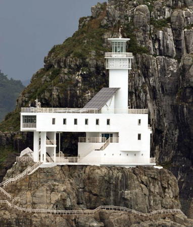
1999 (station established 1937). Active; focal plane 53 m (174 ft); white flash every 10 s. 28 m (92 ft) round cylindrical concrete tower with lantern and gallery, rising from a 3-story concrete keeper's house. Entire lighthouse is white. This remarkable lighthouse is perched atop a steep-sided rocky pinnacle. Trabas has Smith's photo (also seen at right), L. Matticus has a fine photo, Wikimedia has a U.S. Navy photo by Erin Devenberg, Martin Watson has a more distant view, a 2007 view from the sea is available, another view from the sea has the city in the right background, and Google has a satellite view. Oryukdo is a chain of five picturesque islets (or six at high tide) east of the entrance to Busan harbor. All vessels entering or leaving must pass close to the lighthouse, and this familiarity has made it a symbol of the city. Located on the southernmost islet, Deungdaeseom ("Lighthouse Islet"). Accessible only by boat. Site and tower closed but sightseeing boats and tours pass close to the lighthouse. ARLHS SKR-046; KR-2001; Admiralty M4374; NGA 16732.
Busan Middle (Oryukdo) Breakwater Northeast End (2?)
Date unknown. Active; focal plane 17 m (56 ft); yellow flash every 5 s. 12 m (39 ft) round cylindrical concrete tower with lantern and gallery, painted yellow. Trabas has Smith's photo, the lighthouse is at the far left in Tom Wisdom's photo, another photo is available, Alamy.com has a commercial photo of both breakwater lighthouses, and Google has a satellite view. Located at the north end of the detached middle breakwater in the outer entrance to Busan. Accessible only by boat. Site and tower closed. KR-2002; Admiralty M4356.7; NGA 16733.
Busan Middle (Oryukdo) Breakwater Southwest End (2?)
Date unknown. Active; focal plane 20 m (66 ft); red 2 s on, 2 s off. 15 m (49 ft) round cylindrical concrete tower with lantern and gallery, painted red. Trabas has Smith's photo, Getty Images has a closeup photo, the lighthouse is on the right in Tom Wisdom's photo, Irvin Chen has a distant sea view, and Google has a satellite view. Located at the south end of the detached middle breakwater in the outer entrance to Busan; the main channel passes between this light and the south outer breakwater light (see below). Accessible only by boat. Site and tower closed. KR-2003; Admiralty M4356.6; NGA 16733.1.
North Outer Harbor South Breakwater
Date unknown. Active; focal plane 9 m (30 ft); three red flashes every 7 s. 6 m (20 ft) round red concrete tower attached to a pierhead building. No photo available but Google has a satellite view. Located on the south (really east) breakwater of a harbor basin behind the Middle Breakwater. Site status unknown. KR-2003.6; Admiralty M4356.9; NGA 16732.9.
 

Oryukdo Light, Busan
photo copyright Jim Smith; used by permission
North Outer Harbor West Breakwater
Date unknown. Active; focal plane 9 m (30 ft); three green flashes every 7 s. 6 m (20 ft) round white concrete tower attached to a pierhead building. No photo available but Google has a satellite view. Located on the west breakwater of a harbor basin behind the Middle Breakwater. Site status unknown. KR-2003.5; Admiralty M4356.8; NGA 16732.8.
* North Harbor (North Inner Harbor (1))
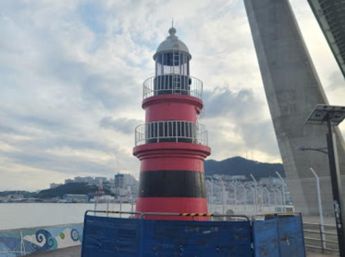
1905. Inactive. Approx. 12 m (39 ft) round concrete tower with lantern and double gallery. Lighthouse painted with red and black horizontal bands; lantern dome painted white. A 2021 photo is at right. The Busan Harbor Bridge, completed in 2014 and seen in Google's satellite view, now crosses this location. A small plaza has been built under the bridge and around the lighthouse and parking is available nearby. Site open, tower closed.
#North Inner Harbor (2)
Date unknown. Inactive since 2007 and demolished shortly thereafter. This was a 20 m (66 ft) round cylindrical concrete tower with lantern and gallery, painted red. No photo available. The Admiralty reported this light discontinued in January 2008. It was located in the water about 40 m (130 ft) southwest of the original lighthouse. The Busan Harbor Bridge, seen in Google's satellite view, now crosses this location. ex-Admiralty M4358; ex-NGA 16740.1.
North Inner Harbor (Gamman Wharf)
Date unknown. Active; focal plane 11 m (36 ft); two red flashes every 6 s. 10 m (33 ft) round concrete tower. Entire lighthouse is red. A 2020 photo is available, Chanaka Weerasena has a good view from the Harbor Bridge, and Google has a satellite view. Located at the end of a commercial pier just north of the Harbor Bridge. Site status unknown. Admiralty M4359; NGA 16748.5.

North Harbor Light, Busan, October 2021
Google Maps photo by 광주송바라기
 

Dong-gu (East District) Lighthouses
*** Busan (Yongdusan) Tower
2010 (tower built 1973). Possibly active but dropped from the official list; formerly listed with focal plane 180 m (591 ft); white flash every 15 s visible only along the harbor approaches from the east and south. 119 m (390 ft) round cylindrical concrete tower topped by an octagonal observation room. Wikimedia has numerous photos, Lightphotos.net has a night time photo, and Google has a street view and a satellite view. A very popular tourist attraction, the Busan Tower provides spectacular views of the city and harbor. In November 2009 the Busan Port Office announced plans to install a powerful directional light atop the tower. It was activated in 2010 but dropped from the official Korean list in April 2018. Located on a low hilltop in Yongdusan Park in downtown Busan. Site and tower open. . ex-KR-2027.17; ex-Admiralty M4371.
Busan Hang Approach Range Front
2013. Active; focal plane 365 m (1198 ft); continuous green light. 42 m (138 ft) square skeletal tower with gallery. A photo is available and Google has a satellite view. This is an entrance range for the harbor. Located on the mountainside northwest of Busan. Site status unknown. Admiralty M4365.6.
Busan Hang Approach Range Rear
2013. Active; focal plane 460 m (1509 ft); continuous green light. 60 m (197 ft) square skeletal tower with gallery. No photo available but Google has a satellite view. Located 991 m (0.61 mi) northwest of the front light. Site status unknown. Admiralty M4365.61.
Buk Hang (North Port) Leading
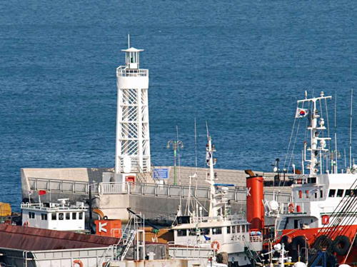
2019. Active; focal plane 24 m (79 ft); continuous light, white, red or green depending on direction. 23 m (75 ft) square white skeletal tower. Yoo Geun-hwa has a distant view and Google has a drone view and a satellite view. This light guides ferries and cruise ships to a new International Passenger Terminal at the north end of Busan harbor adjacent to the downtown area; it is on the same line as the Approach Range Lights. Located at the end of the cruise ship pier. Site status unknown. Admiralty M4365.56.

Jung-gu (Central District) Lighthouse
Buk Hang (North Port) North Breakwater
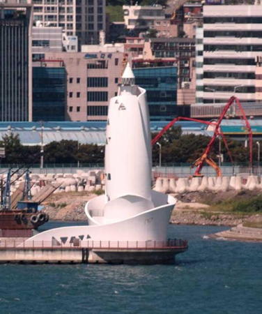
2014. Active; white light, focal plane 30 m (98 ft); two green flashes every 6 s. 29 m (95 ft) round white concrete tower with lantern. The tower has an unusual and striking design seen in Smith's photo at right posted by Trabas and in a 2016 photo. Changjeol You has a view from atop the Busan Tower and Google has a photo and a satellite view. Located at the north end of the pier at downtown Busan. Site status unknown. KR-2025.1; Admiralty M4365.51.

North Port North Breakwater Light, Busan
photo copyright Jim Smith; used by permission

Yeongdo District Lighthouses
Yeongdo is an island about 8 km (5 mi) long and up to 3.5 km (2 mi) wide. The island separates the city's main harbor on the north from the south harbor.

Deungmudari (2)
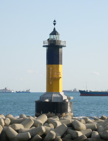
Date unknown (station established 1911). Active; focal plane 12m (39 ft); quick-flashing white light. 13 m (46 ft) round cylindrical concrete tower with lantern and gallery. Upper half of the lighthouse painted black, lower half yellow. Trabas has Smith's photo and Google has a satellite view. Located on a shoal in the inner harbor of Busan about 500 m (0.4 mi) west of the south breakwater lighthouse. Accessible only by boat. Site open, tower closed. KR-2026; Admiralty M4360; NGA 16748.
#Inner Harbor South Breakwater
Date unknown. Removed in 2020. This was a 16 m (52 ft) round concrete tower with lantern and gallery, originally painted green and later white. Trabas has a photo. When the North Harbor Bridge was built the breakwater was removed and the lighthouse stood for several years on a corner of one of the bridge's piers. Google has a satellite view that confirms the removal of the lighthouse. ex-KR-2023; ex-Admiralty M4361; NGA 16740.2.
Bukbin
Date unknown. Active; focal plane 10 m (33 ft); green flash every 5 s. 10 m (33 ft) round skeletal tower with gallery and an open lantern structure. Lighthouse painted white. Trabas has Smith's photo (seen at right) and Google has a street view and a satellite view. Located at the end of an L-shaped breakwater on the south side of Busan harbor. Site status unknown. Admiralty M4356.58; NGA 16739.

Bukbin Light, Busan
photo copyright Jim Smith; used by permission
Haegyeong (2)
2013. Active; focal plane 18 m (59 ft); green flash every 4 s. 13 m (43 ft) round cylindrical concrete tower with lantern and gallery, painted white. Trabas has Smith's photo and Google has a a 2018 street view and a satellite view. Google has a very distant 2010 street view of the original lighthouse; it was removed when the pier was extended in 2012-13. Located at the end of the Coast Guard pier on the south side of Busan harbor. Site status unknown. KR-2007.1; Admiralty M4356.55; NGA 16738.
Busan South Outer (Jodo) Breakwater East End
Date unknown. Active; focal plane 20 m (66 ft); green light, 2 s on, 2 s off. 13 m (46 ft) round cylindrical concrete tower with lantern and gallery, painted white. D. Kovtyukh's photo is at right, Trabas has Smith's photo, Bohao Zhao has a view from the harbor, and Google has a satellite view. Located at the east end of the detached breakwater off the island of Jodo on the southwest side of the outer entrance to Busan. Accessible only by boat. Site and tower closed. KR-2005; Admiralty M4356.4; NGA 16734.
Busan South Outer (Jodo) Breakwater West End
Date unknown. Active; focal plane 16 m (52 ft); yellow flash every 5 s. 10 m (33 ft) round cylindrical concrete tower with lantern and gallery, painted yellow. Trabas has Smith's photo and Google has a satellite view. Located at the west end of the detached breakwater on the southwest side of the outer entrance to Busan. Accessible only by boat. Site and tower closed. Admiralty M4356.5; NGA 16735.
Dongsandong (Tongsandong) Breakwater
Date unknown. Active; focal plane 14 m (46 ft); green flash every 5 s. 9 m (30 ft) round cylindrical concrete tower with lantern and gallery, painted white. Trabas has Smith's photo, a distant view from the sea is available, and Google has a street view and a satellite view. Located on the breakwater of a small basin on the south side of Jodo. Site status unknown. KR-2006; Admiralty M4356.2; NGA 16736.
Busan Jodo Breakwater East End Light
Jodo Breakwater East End Light, Busan, September 2008
ex-Panoramio photo copyright D. Kovtyukh; used by permission
* Yeongdo (Yong Do, Taejongdo, Mokdo) (1) (lantern)
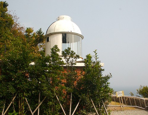
1906. Inactive since 2004. 7 m (23 ft) round lantern mounted on a square 1-story red brick base. Lantern painted white. Brian Yap's photo appears at right and Google has a satellite view. Located about 150 m (500 ft) west of the modern lighthouse. Site open, tower closed.
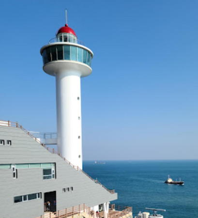
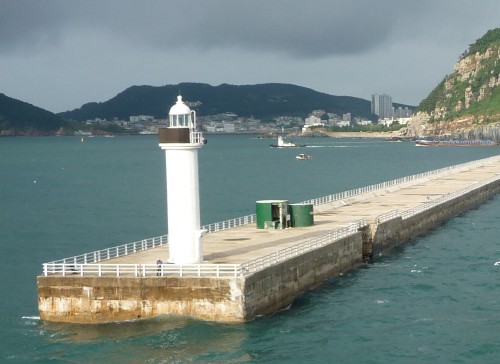
**** Yeongdo (Yong Do, Taejongdae, Mokdo) (2)
2004 (station established 1906). Active; focal plane 82 m (269 ft); three white flashes every 18 s. Approx. 30 m (89 ft) round cylindrical steel tower with lantern and a large circular observation deck. Lighthouse painted white, lantern dome gray. Fog siren (blast every 45 s). A 2021 photo is at the top of this page, Brian Yap has a 2006 photo, Michael Mellinger has a 2008 photo, Lightphotos.net has a January 2013 photo, Trabas has Smith's twilight photo of the light in action, Fidel Guico has a street view, and Google has a satellite view. This modern lighthouse is one of Busan's best known tourist attractions. The station includes an observation deck, See & Sea Gallery, Maritime Library, Information Library, and Natural History Exhibition Hall, as well as several interesting monuments and sculptures. The port authority describes it as an "open maritime cultural space." Yeongdo is an island about 8 km (5 mi) long and 4 km (2.5 mi wide) lying on the south side of Busan's main harbor. The lighthouse stands in a large park, Taejongdae Park, at the southeastern end of the island, where it serves as the port's landfall light. Site open, museum and observation deck open daily. Site manager: Port of Busan. . ARLHS SKR-029; KR-2004; Admiralty M4356; NGA 16728.
Saengdo (Sangdo)
Date unknown. Active; focal plane 57 m (187 ft); two white flashes every 5 s. 24 m (79 ft) round concrete tower, painted black with one red horizontal band. A closeup is available, Kristin Licitis has a nice view, Trabas has Smith's twilight photo of the light in action, Lightphotos.net has a very distant view, and Google has a satellite view. Located atop a small island about 2 km (1.2 mi) south of the Yeongdo lighthouse. Accessible only by boat. Site status unknown. KR-2050; Admiralty M4355.9; NGA 16727.8.


1906 Yeongdo Light, Yeongdo District, October 2006
Flickr Creative Commons photo by Brian Yap

Busan South Inner Harbor Entrance East Breakwater (2)
Date unknown. Active; focal plane 22 m (72 ft); red flash every 5 s. 16 m (52 ft) round cylindrical concrete tower with lantern and gallery, painted red. Anthony Chang has a 2023 closeup photo, Trabas has Smith's photo, a 2008 photo is available, and Google has a street view and a satellite view. The South Inner Harbor is the harbor on the west side of Yeongdo. Located at the end of the short east breakwater at the entrance to the harbor. Site status unknown. KR-2027; Admiralty M4368; NGA 16756.

Seo-gu (West District) Lighthouses
Busan South Inner Harbor Entrance West Breakwater
Date unknown. Active; focal plane 14 m (46 ft); green flash every 5 s. 12 m (39 ft) round cylindrical concrete tower with lantern and gallery, painted white. Trabas has Smith's photo, a 2008 photo is available, and Google has a distant street view and a satellite view. Located at the end of the short west breakwater, at the entrance to the harbor. Site status unknown. KR-2028; Admiralty M4366; NGA 16752.
Busan South Harbor (Songdo)
Date unknown. Active; focal plane 13 m (43 ft); three quick white flashes every 10 s. 15 m (49 ft) octagonal cylindrical concrete tower with lantern and gallery. Upper half of the lighthouse painted black, lower half yellow. Moon Kee Cheong's photo is at right, Andrew Chung has a good photo, a 2018 photo and a 2008 photo are available, and Google has a satellite view. Walkways built over the water provide an excellent view of this lighthouse, as demonstrated by MeiMei Ng's street view. Located close offshore on the west side of the south entrance to Busan harbor. Accessible only by boat but easily seen from shore. Site open, tower closed. KR-2028.50; Admiralty M4369.45; NGA 16757.

Information available on lost lighthouses:

Notable faux lighthouses:

Busan South Light
Busan South Harbor Light, Seo District, November 2008
ex-Panoramio photo copyright Moon Kee Cheong (Moongs™)
used by permission

Adjoining pages: North: Northern Busan | South: Southern Busan

Return to the Lighthouse Directory index | Ratings key

Posted December 4, 2007. Checked and revised December 3, 2023. Lighthouses: 26. Site copyright 2023 Russ Rowlett and the University of North Carolina at Chapel Hill.