Lighthouses of South Korea: Jindo

For most of its history Korea was an independent kingdom or at least an autonomous kingdom under Chinese influence. This came to an end in 1910 when Japan annexed all of Korea. At the end of World War II in 1945 the 38° parallel was established as the dividing line between U.S. and Soviet zones of occupation, and in 1948 separate civil administrations were established in the two halves of the country. The Korean War (1950-53) ended in a draw, with the armistice line falling close to the prewar 38° line. The Republic of Korea (ROK), commonly called South Korea, occupies the Korean peninsula south of the armistice line.

South Korea is divided into nine provinces and eight province-level cities; the provinces are subdivided into counties and cities. This page covers lighthouses of the island county of Jindo (formerly spelled Chindo) in Jeollanam Province, located off the southwestern tip of Korea in the region formerly known as Jeolla or Cholla. The county includes a large island, also called Jindo, and numerous small islands.

In 2000 South Korea adopted a Revised Romanization System to replace systems formerly used in the West. In the Revised System, the word for a lighthouse is deungdae (등대); dan (formerly tan) is a cape, seom (som) or do (to) is an island, am or amseog is a rock, man is a bay, and hang is a harbor. Some place names may be more familiar to Westerners in the spellings of older systems.

Navigational aids in the ROK are regulated by the Ministry of Oceans and Fisheries (MOF). Lighthouses in Jindo are maintained by the Mokpo Regional Oceans and Fisheries Administration.

ARLHS numbers are from the ARLHS World List of Lights. KR numbers, where available, are from the Korean light list. Admiralty numbers are from volume M of the Admiralty List of Lights & Fog Signals. U.S. NGA List numbers are from Publication 112.

General Sources
Port of Mokpo - Lighthouses
Photos and information in English for the major lighthouses of the area.
World of Lighthouses - South Korea
Photos by various photographers available from Lightphotos.net.
Online List of Lights - Korea
Photos by various photographers posted by Alexander Trabas.
Navionics Charts
Navigation chart for Jindo.


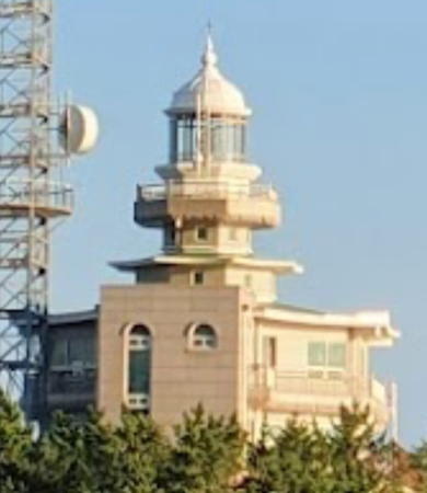
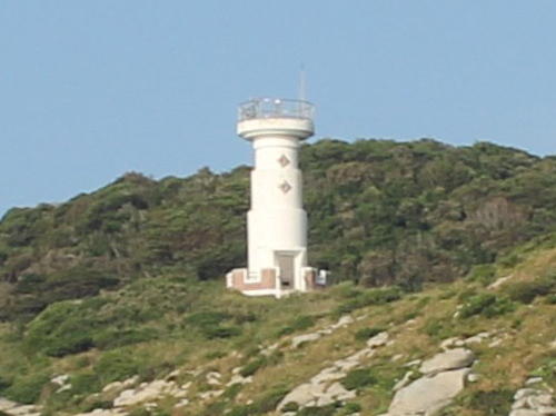
Gasado Light, Gasado, September 2021
Google Maps photo by J.G. Jeon

Jindo Island Area Lighthouses

Jindo is the third largest island of South Korea. It is separated from Haenam County on the mainland by the Myeongnyang Strait, crossed by the Jindo Bridge. The strait narrows to about 300 m (330 yd) in width and is subject to very strong tidal currents.

Gogun Township (East Coast) Lighthouse
Hoedong Hang Breakwater
2018. Active; focal plane 14 m (46 ft); green flash every 5 s. 12 m (39 ft) hexagonal concrete tower with lantern and gallery. Entire lighthouse is white. Park Jong-Sam's 2020 photo is at right and Google has a satellite view. Located at the end of the breakwater at Hoedong harbor on the east coast of Jindo. Site open, tower closed. KR-3007.9; Admiralty M4278.7.

Uisin Township (Southeast Coast) Lighthouses
Supum Hang East Breakwater
2018. Active; focal plane 14 m (46 ft); red flash every 4 s. 8 m (26 ft) round red concrete tower. Willis Park has a view across the harbor, Lee Jeong-ju has a 2020 view from the sea, Unsik Jang has a 2022 view of both breakwater lights, and Google has a satellite view. Located at the west end of a detached breakwater at Supum Hang, a harbor on Jeopdo, an island just off the south coast of Jindo. Accessible only by boat. Site open, tower closed. KR-3006.8; Admiralty M4278.6.
Supum Hang West Breakwater
2018. Active; focal plane 14 m (46 ft); green flash every 4 s. 8 m (26 ft) round white concrete tower. Willis Park has a view across the harbor, Unsik Jang has a 2022 view of both breakwater lights, and Google has a satellite view. Located on the west (really south) breakwater at Supum Hang. Site status unknown. KR-3006.7; Admiralty M4278.5.
Jeopdo
Date unknown. Active; focal plane 15 m (49 ft); six quick white flashes followed by one long white flash every 15 s. 16 m (52 ft) round tower, upper half painted yellow and lower half black. A very distant view is available and Google has a fuzzy satellite view. Located just off the rocky southeast tip of the Jeopdo Peninsula southwest of Supum. Accessible only by boat. Site open, tower closed. KR-3006.1; Admiralty M4278.45.
Gujado (Guja-do, Hagujado, Ku Do)
1996. Active; focal plane 42 m (138 ft); two white flashes every 6 s. 8 m (26 ft) round white concrete tower. A closeup photo is available and Bing has a distant satellite view. Located at the southeastern end of an island about 10 km (6 mi) off the southeastern coast of Jindo. Accessible only by boat. Site status unknown. KR-3007; Admiralty M4278.4; NGA 17544.

Hoedang Hang Light, Jindo, September 2020
Google Maps photo by Park Jong-Sam

Imhoe Township (South Coast) Lighthouses
Gulpo
2016. Active; focal plane 21 m (69 ft); white flash every 5 s. 8 m (26 ft) hexagonal metal tower painted white. No photo available but Google has a satellite view. Located on a headland near Gulpo village on the south cost of Jindo. Site status unknown. KR-3030.3; Admiralty M4246.505; NGA 17546.
Bulmudo (Pulmudo, Pulmu Do)
Date unknown. Active; focal plane 45 m (148 ft); white flash every 4 s. 10.5 m (34 ft) round white concrete tower. No photo available but Bing has a satellite view. Located at the northwestern end of an island about 3 km (2 mi) off the southern tip of Jindo. Accessible only by boat. Site status unknown. KR-3030; Admiralty M4246.5; NGA 17558.
* Seomang (Somang) Hang South Breakwater (?)
Date unknown. Apparently removed; listed with focal plane 15 m (49 ft); two red flashes every 6 s. 10 m (33 ft) round cylindrical concrete tower. Entire lighthouse is red. Kim Beom-seok has a closeup 2021 street view and Lee Jeong-moon has a photo of the two Seomang lighthouses but they are missing in Google's satellite view. Seomang is the terminal for ferries to the more remote islands of Jindo County. Located at the end of the south breakwater of Seomang, at the southern end of Jindo. Accessible by walking the pier. Site open, tower closed. KR-3043; Admiralty M4246.6; NGA 17581.
* Seomang (Somang) Hang North Breakwater (?)
Date unknown. Apparently removed; listed with focal plane 15 m (49 ft); green flash every 6 s. 10 m (33 ft) round cylindrical concrete tower. Entire lighthouse is white. Kim Beom-seok has a closeup 2021 street view, Lee Jeong-moon has a photo of the two Seomang lighthouses but they are missing in Google's satellite view. Seomang is the terminal for ferries to the more remote islands of Jindo County. Located at the end of the south breakwater of Seomang, at the southern end of Jindo. Accessible by walking the pier. Site open, tower closed. KR-3044; Admiralty M4246.65; NGA 17581.5.
* Paengmok Hang
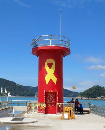
2018. Active; focal plane 11 m (36 ft); red flash every 4 s. 8 m (26 ft) round red concrete tower. Baek Jang-hyun's 2020 photo is at right, Kim Cheol Bong has a closeup photo, and Google has a satellite view. Located on the breakwater at Paengmok, a village just north of Seomang. Accessible by walking the pier. Site open, tower closed. KR-3044.7; Admiralty M4246.58.

Uishin Township (West Coast) Lighthouses
Geupchisan (Jindo Southwest)
Date unknown. Active; focal plane 11 m (36 ft); two white flashes every 6 s. 8 m (26 ft) round white concrete tower. No photo available but Google has a distant satellite view. This light is listed as Jindo by the Admiralty and as Chindo by NGA. Located at the tip of a steep promontory at the southwestern tip of Jindo. Accessible only by boat. Site status unknown. KR-3045; Admiralty M4246.55; NGA 17581.8.
Buldo (Puldo, Pulto)
Date unknown. Active; focal plane 52 m (171 ft); white flash every 6 s. 10 m (33 ft) round white concrete tower. No photo available but Google has a satellite view. Located on an islet off the western tip of Jindo, south of Gasado. Accessible only by boat. Site status unknown. Admiralty M4232.6; NGA 17582.
Galduri (Kalduri)
Date unknown. Active; focal plane 14 m (46 ft); two white flashes every 10 s. 11 m (36 ft) round concrete tower. Lighthouse painted black with one red horizontal band. No photo available but Google has a satellite view. Located on an isolated rock about 1.6 km (1 mi) off the western tip of Jindo. Accessible only by boat. Site status unknown. KR-3050; Admiralty M4233; NGA 17583.

Jisan Town Lighthouses
Jeodo (Chodo, Cho Do)
Date unknown. Active; focal plane 11 m (36 ft); two white flashes every 6 s. 8 m (26 ft) round white concrete tower. No photo available but Google has an indistinct satellite view. Located on the northwest point of an island off the northwest coast of Jindo. Accessible only by boat. Site status unknown. Admiralty M4234; NGA 17592.
Sopo
Date unknown. Active; focal plane 10 m (33 ft); two white flashes every 6 s. 8 m (26 ft) round white concrete tower. No photo available but Google has an indistinct satellite view. Located at the tip of a promontory sheltering the harbor of Sopo, a ferry terminal on the northwest coast of Jindo. Site status unknown. KR-3049.1; Admiralty M4233.5.

Paengmok Hang Light, Jindo, August 2020
Google Maps photo by Baek Jang-hyun

Jindo County: Jodo Islands Lighthouses

The Jodo Township (Jodo myeon) includes a broad scattering of 154 islands, 35 of them inhabited, lying to the south and west of Jindo Island. The Township has 33 villages (ri) and a total population of about 3300. The larger inhabited islands are accessible by ferry from Seomang on Jindo Island.

Boksacho Lighthouse
Boksacho (2)
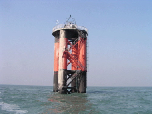
2009 (station established 2003). Active; focal plane 17 m (56 ft); two white flashes every 10 s. 29 m (92 ft) round scientific platform supported by four robust piles. Structure painted black with a broad red horizontal band. A photo is at right, an excellent closeup photo (1/3 the way down the page) is available, Kim Beomseok has a more distant view, and Bing has a distant satellite view. This tower is an observing station of the Korean Hydrographic and Oceanographic Adminstration (KHOA). Located about 15 km (9 mi) southeast of the Jodo Islands and a similar distance northwest of the Chuja Islands. Accessible only by boat. KR-3019; Admiralty M4242.6; NGA 17549.

Hajodo Area Lighthouses
Hajodo, the largest of the Jodo Islands, is about 7 km (4.5 mi) long and is located 8 km (5 mi) southwest of Jindo. A bridge links Hajodo to the neighboring island of Sangjodo, just to the north. A popular tourist destination, the island has a population of about 1800 and is readily accessible by ferry.

Hangando
Date unknown. Active; focal plane 32 m (105 ft); two white flashes every 6 s. 8 m (26 ft) octagonal white concrete tower. No photo available but Bing has a satellite view. Located on an isolated high islet southwest of Jindo and about 4 km (2.5 mi) east northeast of Hajodo. Accessible only by boat. Site status unknown. KR-3013; Admiralty M4246.51; NGA 17559.
Jangjukdo (Changjukdo, Changjukto)
Date unknown. Active; focal plane 18 m (59 ft); white flash every 6 s. 8.5 m (28 ft) octagonal white concrete tower. A distant view is available and Bing has a satellite view. Located at the north end of an island in the strait between Jindo and Hajodo. Accessible only by boat, but ferries between Seomang and Hajodo pass close to this light. Site status unknown. KR-3012; Admiralty M4246.52; NGA 17559.5.
Boksacho Light
Boksacho Light
Korean Hydrographic and Oceanographic Adminstration photo
* Hajodo (Hajo-do, Hojodo)
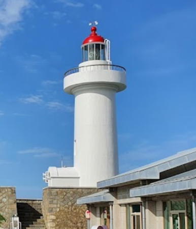
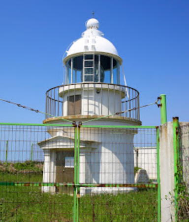
1909. Active; focal plane 48 m (158 ft); white flash every 10 s. 14 m (46 ft) round cylindrical concrete tower with lantern and gallery. Fog siren (blast every 55 s). Entire station painted white. Fog siren (one blast every 55 s). J.G. Jeon's 2021 photo is at right, Kim Hyungnam has a 2017 closeup photo, Park Hyung Kyu has a photo, Jodo Township posted a photo, Park Seong-soo has a 2020 street view, and Google has a satellite view. Located at the tip of a very sharp promontory at the northeastern tip of Hajo-do. Accessible by road. Site open, tower closed. . ARLHS SKR-008; KR-3014; Admiralty M4246; NGA 17556.
Heukseo
2007. Active; focal plane 13 m (43 ft); three white flashes every 10 s. 17 m (56 ft) round cylindrical concrete tower, painted black with one yellow horizontal band, mounted on a round concrete pier. A distant view is available and Google has a satellite view. Located on a reef about 1 km (0.6 mi) southeast of the Hajodo lighthouse. Accessible only by boat. Site open, tower closed. Admiralty M4245.
Oemindongseo (Hwichuyeo)
Date unknown. Active; focal plane 11 m (36 ft); nine quick white flashes every 15 s. 10 m (33 ft) concrete tower painted yellow with one black horizontal band. No photo available but Google has a satellite view. The light marks the narrow channel between Hajodo and Jukhangdo. Located just off the southeastern tip of Hajodo. Accessible only by boat. Site open, tower closed. KR-3006.9; Admiralty M4249.88.
Damchuseo
2016. Active; focal plane 18 m (59 ft); white flash every 4 s. 8 m (26 ft) octagonal white concrete tower. No photo available but Bing has a satellite view. Located on a small island about 2.5 km (1.5 mi) southeast of Hajado. Accessible only by boat. Site open, tower closed. KR-3028; Admiralty M4249.91.
Nabaedo
2015. Active; focal plane 10 m (33 ft); green flash every 4 s. 10 m (33 ft) round concrete tower painted green. No photo available but Google has a satellite view. Located just off the eastern tip of Nabaedo, marking the narrow passage between Hajado and Nabaedo. Accessible only by boat. Site open, tower closed. Admiralty M4247.1.
#Semog
Date unknown. Inactive since 2017 and apparently demolished. This was an 8 m (26 ft) round white concrete tower with gallery. The light is not seen in Google's satellite view. This light, marking the narrow passage between Hajado and Nabaedo, became redundant after the Nabaedo Light was installed. Located on the western tip of Hajodo. Site status unknown. ex-KR-3017; ex-Admiralty M4247; NGA 17560.

Hajodo Light, Hajodo, August 2021
Google Maps photo by jg “choco” jeon
Gyeongseocho (Dang Dan)
Date unknown. Active; focal plane 10 m (33 ft); two white flashes every 5 s. 10 m (33 ft) round concrete tower, painted black with one red horizontal band. The light is at the right edge in a 2021 photo of the Jodo bridge and Google has a satellite view. Located on a shoal east of the bridge joining Hajodo to Sangjodo. Accessible only by boat. Site open, tower closed. Admiralty M4246.8; NGA 17557.

Gwanmaedo Area Lighthouses
Gwanmaedo is a smaller island south of Hajodo.

Yeonchulseo
Date unknown. Active; focal plane about 11 m (36 ft); six quick white flashes followed by one long white flash every 15 s. Approx. 11 m (36 ft) concrete tower, upper half painted yellow and lower half black. No photo available but Google has a satellite view. Located off the west end of Modo, and island off the western tip of Hajodo. Accessible only by boat. Site open, tower closed. KR-3009; Admiralty M4249.6; NGA 17561.
Haesuseo (Haesu Seo, Haesu So)
Date unknown. Active; focal plane 11 m (36 ft); two white flashes every 10 s. 11 m (36 ft) round concrete tower, painted black with one red horizontal band. No photo available but Bing has a satellite view. Located on a reef southwest of Hajodo and halfway between Daemado and Gwanmaedo. Accessible only by boat. Site open, tower closed. KR-3029; Admiralty M4249.8; NGA 17562.
Cheongdeungdo
Date unknown. Active; focal plane 17 m (56 ft); nine quick white flashes every 15 s. 10 m (33 ft) concrete tower painted yellow with one black horizontal band. No photo available but Google has a satellite view. Located off the west end of Cheongdeungdo, marking the narrow channel between that island and Gwanmaedo. Accessible only by boat. Site open, tower closed. KR-3014.3; Admiralty M4249.85.
Gochiseo (Kyo So)
Date unknown. Active; focal plane about 16 m (52 ft); six quick white flashes followed by a longer white flash. Approx. 15 m (49 ft) round concrete tower with lantern and gallery, upper half painted yellow and lower half black. No photo available but Google has a satellite view. Located on a shoal off the southern tip of Gwanmaedo. Accessible only by boat. Site open, tower closed. KR-3001.4; Admiralty M4249.83.
Geomado (Komado, Koma-do)
Date unknown. Active; focal plane 50 m (164 ft); white flash every 4 s. 10 m (33 ft) round white concrete tower. An MOF photo is at right and Google has a satellite view. Located on a high islet at the southern end of the southwestern island group. Accessible only by boat. Site status unknown. KR-3014.2; Admiralty M4249.7; NGA 17563.

Geomado Light, Jodo
Ministry of Oceans and Fisheries photo

Geocha Islands Lighthouses
The Geocha Islands are near the outermost edge of the Jodo Islands, about 13 km (8 mi) southwest of Hajado.

Seogeochado
Date unknown. Active; focal plane 30 m (98 ft); white flash every 6 s. 6 m (20 ft) round white concrete tower. No photo available but Google has a distant satellite view. Located at the eastern tip of the island of Seogeochado. Site status unknown. Admiralty M4249; NGA 17564.
 
* Seogeochado East Breakwater
Date unknown. Active; focal plane 14 m (46 ft); red flash every 4 s. 8.5 m (28 ft) round cylindrical concrete tower. Entire lighthouse is red. Several photos are available and Google has a satellite view. Located at the end of the east breakwater of Seogeochado. Accessible by walking the pier. Site open, tower closed. KR-3021; Admiralty M4249.2; NGA 17568.
* Seogeochado West Breakwater
Date unknown. Active; focal plane 14 m (46 ft); green flash every 4 s. 8.5 m (28 ft) round cylindrical concrete tower. Entire lighthouse is white. Several photos are available and Google has a satellite view. Located at the end of the west breakwater of Seogeochado. Accessible by walking the pier. Site open, tower closed. KR-3022; Admiralty M4249.4; NGA 17572.

Maenggol Islands Lighthouses
Maenggoldo and the neighboring island of Jukdo are the outermost inhabited islands of the Jodo Islands, about 5 km (3 mi) southwest of Seogeochado.

Byeongpungdo (Pyongpungdo)
Date unknown. Active; focal plane 47 m (154 ft); white flash every 6 s. 9 m (30 ft) round white concrete tower. A photo (halfway down the page) is available and Google has a distant satellite view. Pyongpungdo is an island about 25 km (15 mi) south southwest of Jindo. Located at the southern tip of the island. Accessible only by boat. Site status unknown. KR-3023; Admiralty M4250; NGA 17580.
Jukdo (Chukdo, Chuk-to)
1907. Active; focal plane 85 m (279 ft); white flash every 10 s. 9 m (30 ft) round cylindrical concrete tower with lantern and gallery. Rotating aerobeacon. Lighthouse painted white. Fog horn (one blast every 35 s). A 2023 photo is at right, Jeollanam Province posted a nice photo, and Google has a distant satellite view. Located on a small island near the extreme southwestern corner of Korean territory, about 25 km (15 mi) southwest of Jindo. Accessible only by boat. Site status unknown. KR-3025; Admiralty M4248; NGA 17576.
Byeonseo (Pyonso)
Date unknown. Active; focal plane 11 m (36 ft); two white flashes every 5 s. 13 m (43 ft) tower, painted black with one red horizontal band. No photo available and the reef is not seen in Google's satellite view of the location. Located on a rock about 4 km (2.5 mi) southwest of Jukdo. Accessible only by boat. Site status unknown. Admiralty M4248.5; NGA 17577.

Jukdo Light, Jukdo, May 2023
Google Maps photo by jg “choco” jeon
 

Seongnam Islands Lighthouses
These islands are in the northern part of the Jodo Islands, northwest of Hajodo.
Nurokdo (Nulogdo, Nulokdo)
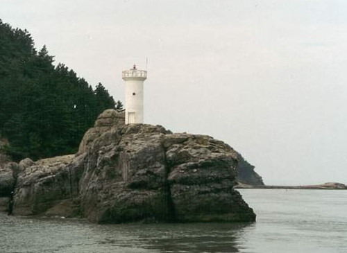
2004. Active; focal plane 13 m (43 ft); white flash every 4 s. 8.5 m (28 ft) round white concrete tower. A photo is at right, two additional photos are available, and Google has a satellite view. Located on an islet off the southeastern tip of Nurokdo, an island about 3 km (2 mi) south of Eoryongdo. Accessible only by boat. Site status unknown. KR-3018; Admiralty M4247.5; NGA 17552.
Duryangseo (Turyangdo)
Date unknown. Active; focal plane 12 m (39 ft); two white flashes every 10 s. 12 m (39 ft) round concrete tower, painted black with one red horizontal band. No photo available but Bing has an indistinct satellite view. Located on a shoal about 5 km (3 mi) west of Nurokdo. Accessible only by boat. KR-3018.3; Admiralty M4247.6; NGA 17551.8.
Oebyeongdo
1907. Active; focal plane 81 m (266 ft); white flash every 10 s. 10 m (33 ft) octagonal concrete tower with lantern and gallery. Modern 2-story crew quarters building. Entire station painted white. No photo available but Google has an indistinct satellite view. Oebyeongdo is an island about 16 km (10 mi) northwest of Hajodo. Located on the highest point of the island. Accessible only by boat. Site status unknown. KR-3016; ARLHS SKR-019; Admiralty M4247.7; NGA 17554.
Oebyeonghang
Date unknown. Active; focal plane 11 m (36 ft); green flash every 5 s. 14 m (46 ft) round green concrete tower. No photo available but Google has a satellite view. Located just off the breakwater of Oebyeong harbor. Site opn, tower closed. KR-3016.1; Admiralty M4247.65.
Seongnamdo
Date unknown. Active; focal plane 13 m (43 ft); white flash every 4 s. 8 m (26 ft) round white concrete tower. No photo available but Google has an indistinct satellite view. Located at the southeastern tip of Seongnamdo, an island about 5 km (3 mi) southwest of the southwestern tip of Jindo. only by boat. Site status unknown. Admiralty M4247.8; NGA 17581.7.
Nurokdo Light
Nurokdo Light, Nurokdo
Port of Mokpo photo

Gasa Islands Lighthouses
Gasado is an island about 5 km (3 mi) long and 3 km (2 mi) wide, located about 6.5 km (4 mi) off the west coast of Jindo. The island is the site of gold and silver mines, long inactive but now being reopened.
Gadeokdo (Gadogdo, Kadokdo)
Date unknown. Active; focal plane 11 m (36 ft); two white flashes every 6 s. 8 m (26 ft) round white concrete tower. No photo available but Google has a satellite view. Located at the southeastern end of an island about 5 km (3 mi) west southwest of Gasado. Accessible only by boat. Site status unknown. KR-3048; Admiralty M4247.81; NGA 17585.
** Gasado (Kasado, Kasa Do) (2)
2008 (?) (station established 1915). Active; focal plane 75 m (246 ft); white flash every 10 s. 17 m (56 ft) octagonal cylindrical concrete tower with lantern and gallery, painted white, surrounded by an octagonal 3-story building. Fog horn (one blast every 45 s). J.G. Jeon's distant 2021 view is at the top of this page, the Port of Mokpo has a photo, a Seoul newspaper has the same closeup, Jang-oh Lee has a 2021 closeup, a portfolio of distant views is available, and Google has a satellite view. This is a staffed station and the Korea JoongAng Daily has an English language feature article on one of the keepers. The station is being developed as a tourist attraction, although no details are available. Gasado is accessible by ferry from Mokpo. Located on a promontory at the southern tip of the island. Site open, tower status unknown. . ARLHS SKR-042; KR-3049; Admiralty M4232; NGA 17584.
Manseo (Man-so)
Date unknown. Active; focal plane 16 m (52 ft); two white flashes every 10 s. 14 m (46 ft) round concrete tower, painted black with one red horizontal band. No photo available but Bing has a satellite view. Located on a reef about 2.5 km (1.5 mi) northwest of the Gasado light station. Accessible only by boat. Site open, tower closed. Admiralty M4234.8; NGA 17594.
Gwangdaedo
2006. Active; focal plane 31 m (102 ft); white flash every 5 s. 13 m (43 ft) round white concrete tower. A view from the sea is available, another site has the same view (just over halfway down the page), and Google has a satellite view. Located on the northern tip of an island about 8 km (5 mi) northeast of Gasado. Accessible only by boat. Site status unknown. KR-3051.1; Admiralty M4234.5; NGA 17587.5.

Information available on lost lighthouses:

Notable faux lighthouses:

Adjoining pages: North: Sinan | Northeast: Mokpo Area | East: Northern Wando Islands | South: Jeju

Return to the Lighthouse Directory index | Ratings key

Posted January 9, 2008. Checked and revised April 17, 2024. Lighthouses: 45. Site copyright 2024 Russ Rowlett and the University of North Carolina at Chapel Hill.