Lighthouses of South Korea: Mokpo Area

For most of its history Korea was an independent kingdom or at least an autonomous kingdom under Chinese influence. This came to an end in 1910 when Japan annexed all of Korea. At the end of World War II in 1945 the 38° parallel was established as the dividing line between U.S. and Soviet zones of occupation, and in 1948 separate civil administrations were established in the two halves of the country. The Korean War (1950-53) ended in a draw, with the armistice line falling close to the prewar 38° line. The Republic of Korea (ROK), commonly called South Korea, occupies the Korean peninsula south of the armistice line.

South Korea is divided into nine provinces and eight province-level cities; the provinces are subdivided into counties and cities. This page covers lighthouses of the Mokpo area in Jeollanam Province, located on South Korea's southwest coast in the region formerly known as Jeolla or Cholla. This area includes Haenam County, Mokpo City, and the counties of Muan and Yeonggwang north of Mokpo.

In 2000 South Korea adopted a Revised Romanization System to replace systems formerly used in the West. In the Revised System, the word for a lighthouse is deungdae (등대); dan (formerly tan) is a cape, seom (som) or do (to) is an island, am or amseog is a rock, man is a bay, and hang is a harbor. Some place names may be more familiar to Westerners in the spellings of older systems.

Navigational aids in the ROK are regulated by the Ministry of Oceans and Fisheries (MOF). Lighthouses in Sinan are maintained by the Mokpo Regional Maritime Affairs and Port Authority.

ARLHS numbers are from the ARLHS World List of Lights. KR numbers, where available, are from the Korean light list. Admiralty numbers are from volume M of the Admiralty List of Lights & Fog Signals. U.S. NGA List numbers are from Publication 112.

General Sources
Port of Mokpo - Lighthouses
Photos and information in English for the major lighthouses of the area.
Lighthouses in South Korea
Photos available from Wikimedia.
Online List of Lights - Korea
Photos by various photographers posted by Alexander Trabas.
Navionics Charts
Navigation chart for the Mokpo area.


2003 Mokpogu Light, Hwawon, June 2022
Google Maps photo by Im Mi-ran
Haenam County Lighthouses

Songji Township Lighthouses
Yeongjeon Hang
Date unknown. Active; focal plane 7 m (23 ft); red flash every 6 s. 6 m (20 ft) hexagonal metal tower. Entire lighthouse is red. No photo available but Google has a satellite view. Located on the east breakwater of a small port in southeastern Haenam opposite Wando Island. Probably accessible by walking the pier. Site open, tower closed. KR-2590.8; Admiralty M4278.16; NGA 17320.5.
* Galdu Hang
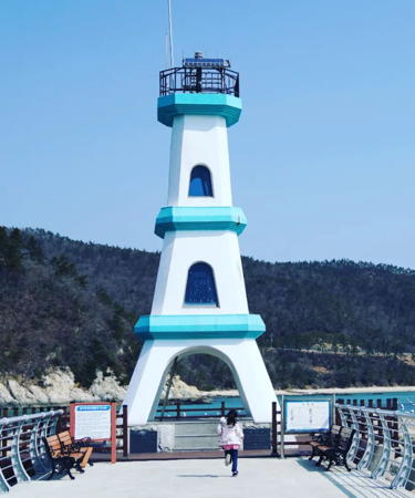
2000. Active (?); focal plane 14 m (46 ft); green flash every 5 s. 11 m (36 ft) tapered square white concrete skeletal tower with gallery. A 2022 photo is at right, Hyun Suhwan has a closeup photo, B.S. Kim has a 2019 photo, and Google has a satellite view. Inspired by the Eiffel Tower, this unusual light stands very close to the southernmost point of the Korean peninsula. The light was dropped from the Admiralty list in 2023. Located at the end of the breakwater at Galdu, a small port in the village of Ttangkkeut ("Land's End") at the south end of Haenam County. Accessible by walking the pier. Site open, tower closed. . KR-2582.7; ex-Admiralty M4279.36; NGA 17533.5.
Yangdo
Date unknown. Active; focal plane 23 m (75 ft); white flash every 5 s. 8.5 m (28 ft) octagonal white concrete tower. No photo available but Google has a satellite view. Located on the south end of an island just off the extreme southwestern point of the Korean mainland, about 2.5 km (1.5 mi) west of Galdu Hang. Accessible only by boat. Site open, tower closed. Admiralty M4279.35; NGA 17534.
Eobuldo
2001(?). Active; focal plane 16 m (52 ft); three white flashes every 7 s. 9 m (30 ft) hexagonal cylindrical skeletal tower with gallery. Entire lighthouse is white. A photo (fifth photo on the page) is available and Google has a satellite view. Located near the south end of an island off Eoran harbor. Accessible only by boat. Site status unknown. KR-3304.1; Admiralty M4278.8; NGA 17535.
* Eoranjin (Eoran) Hang (Oran-ni, Oranchin) East Breakwater
Date unknown. Active; focal plane 12 m (39 ft); red flash every 6 s. 8 m (26 ft) square red concrete tower. Sung Chun Lee has a photo, Shin Hong-sik has a photo and Google has an indistinct satellite view. Located at the end of the east breakwater at Eoran, about 8 km (5 mi) northwest of Galdu Hang. Accessible by walking the pier. Site open, tower closed. KR-3004.5; Admiralty M4279.2.
* Eoranjin (Eoran) Hang (Oran-ni, Oranchin) West Breakwater
Date unknown. Active; focal plane 12 m (39 ft); green flash every 6 s. 8 m (26 ft) round cylindrical white concrete tower. Shin Hong-sik has a photo and Google has an indistinct satellite view. Located at the end of the west breakwater at Eoran, about 8 km (5 mi) northwest of Galdu Hang. Accessible by walking the pier. Site open, tower closed. KR-3005; Admiralty M4279; NGA 17536.

Galdu Hang Light, Songcho, March 2022
Instagram photo by misel_kk14

Hwasan Township Lighthouses
Songpyeong Ri
Date unknown. Active; focal plane 14 m (46 ft); two white flashes every 5 s. 13 m (43 ft) round concrete tower painted black with one red horizontal band. Doohyun Nam has a very distant view and Google has a satellite view. Located on a rock off the village of Songpyeong. Accessible only by boat. Site open, tower closed. KR-3005.3; Admiralty M4279.32.
Sangmado
Date unknown. Active; focal plane 48 m (157 ft); two white flashes every 6 s. 5 m (16 ft) round white concrete tower. No photo available but Google has a satellite view. Located on Sangmado, an island halfway between the east coast of Jindo and the mainland. Site status unknown. Admiralty M4279.3; NGA 17540.

Hwangsan Township Lighthouse
Hwichuyeo
2019. Active; focal plane 9 m (30 ft); nine quick white flashes every 15 s. 10 m (33 ft) concrete tower painted yellow with one black horizontal band. No photo available but Google has a satellite view. Located on a shoal off the harbor of Sinheung. Site open, tower closed. Admiralty M4279.31.

Munnae Township (Myeongnyang Strait) Lighthouses
Bangtan (Pangtangso, Pangtang Rock)
Date unknown. Active; focal plane 13 m (43 ft); red flash every 4 s. 13 m (43 ft) round tower with lantern and gallery, painted red. No photo available but Google has a satellite view. Located on a rock in the Myeongnyang Strait, which separates Jindo from the mainland, about 4 km (2.5 mi) east of the Jindo Bridge. Accessible only by boat. Site open, tower closed. KR-3056; Admiralty M4242; NGA 17604.
Nokdo (Nok Do, Nogto)
Date unknown. Active; focal plane 27 m (89 ft); white flash every 4 s. 8 m (26 ft) round white concrete tower with gallery. Sunghoon Lee has a good photo and Google has a satellite view. Located on the southern tip of the island, marking the southern approach to the Jindo Bridge, about 2.5 km (1.5 mi) southeast of the bridge. Accessible only by boat. Site open, tower closed. KR-3057; Admiralty M4241; NGA 17600.
Imhado (Imha Do) (2?)
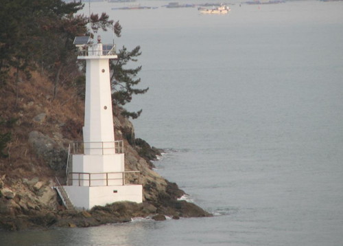
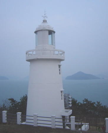
Date unknown. Active; focal plane 21 m (69 ft); two white flashes every 6 s. 6 m (20 ft) round white concrete tower with double gallery. A photo is at right, and Google has a satellite view. Another photo apparently shows an earlier light at this location. Located at the tip of an island projecting westward at the northern entrance to the Myeongnyang Strait. Site status unknown. Admiralty M4238; NGA 17608.
Imhado Light
Imhado Light, Munnae, June 2012
ex-Daum.net Creative Commons photo by balgurac

Hwawon Township (Mokpo Approaches) Lighthouses
Sihado (Chihado)
1907. Active; focal plane 39 m (128 ft); white flash every 12 s. 7.5 m (25 ft) round concrete tower with lantern and gallery, attached to a 1-story concrete keeper's house. Lighthouse painted white. Fog horn (one blast every 35 s). Several additional station buildings. A photo is available and Google has a satellite view of the station. Sibling of the 1908 Mokpogu Light seen at right. Located on a small island on the southern approach to Mokpo, about 16 km (10 mi) southwest of the city. Accessible only by boat. Site status unknown. KR-3066; Admiralty M4220; NGA 17616.
* Mokpogu (Hwawon Bando) (1)
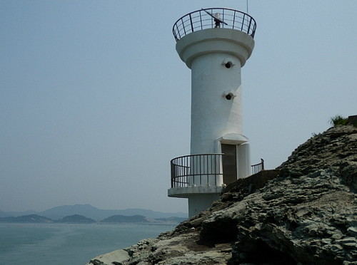
1908. Inactive since 2003. 7 m (23 ft) round cylindrical concrete tower with lantern and gallery, rising from one end of a 1-story concrete keeper's house. Entire lighthouse is white. A 2022 photo is at right, Jo Won-gil has a 2016 closeup, J.G. Jeon has a 2019 photo showing both lighthouses, and the lighthouse can be seen to the right of the new lighthouse in a Google satellite view. The fog siren at the old lighthouse remains active (one 5 s blast every 30 s). Located at the northern tip of a peninsula marking the south side of the entrance to the Hwaweon Strait leading to Mokpo. Site appears open, tower closed.
* Mokpogu (Hwawon Bando, Mokpo Waterway) (2)
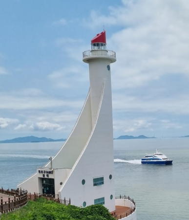
2003 (station established 1908). Active; focal plane 37 m (121 ft); white flash every 5 s. 36 m (118 ft) round cylindrical concrete tower with lantern and gallery attached to a 2-story administration building with sweeping buttresses. Lighthouse painted white, lantern roof red. Im Mi-ran's 2022 photo is at the top of this page, Jo Won-gil has a closeup, Chen Jin-Woo has a 2020 photo, Joni Lahey has a distant view, Choul-O Kim has a street view, and Google has a good satellite view. Located at the extreme tip of the peninsula, near the historic lighthouse. Accessible by road, limited parking available. Site open, tower status unknown. . KR-3079; Admiralty M4217; NGA 17624.
Hwawon (Hwawon Bando East)
Date unknown. Active; focal plane 33 m (108 ft); white flash every 6 s. 8 m (26 ft) round cylindrical concrete tower, rising from a 1-story concrete keeper's house. No photo available but Google has a satellite view. Located on a promontory at the southeastern entrance to the Hwaweon Strait, about 2.5 km (1.5 mi) southeast of the Mokpogu lighthouses. Site status unknown. KR-3082; Admiralty M4217.7; NGA 17625.

1908 Mokpogu Light, Hwawon, November 2022
Google Maps photo by Piano Soul

Mokpo City Lighthouses

Located strategically at the southwestern corner of Korea, the historic seaport of Mokpo has long had trading ties with Japan and China. It is also a major ferry port with lines serving the numerous islands offshore to the south and southwest of the city. The city's urban population is about 250,000.

Dallido Area Lighthouses
Dallido
Date unknown. Active; focal plane 13 m (43 ft); two white flashes every 6 s. 7 m (23 ft) octagonal white concrete tower. A photo is available and Google has a fuzzy satellite view. Located at the southern tip of Dallido, an island on the north side of the entrance to the Hwawon strait that shelters the harbor of Mokpo. Accessible only by boat. Site status unknown. KR-3081; Admiralty M4217.6; NGA 17626.
Oedaldo (Oedalto) (1)
Date unknown. Replaced in 2014. This was an 8.5 m (28 ft) octagonal cylindrical tower. A 2022 photo and a closeup 2011 photo are available. Located near the western tip of Oedalto a short distance east of the new light. Accessible only by boat. ex-Admiralty M4217.2.
Oedaldo (Oedalto) (2)
2014. Active; focal plane 15 m (49 ft); nine quick white flashes every 15 s. 18 m (59 ft) round cylindrical concrete tower painted yellow with a black horizontal band. A 2022 photo is available, Eun Seong Hwang has a photo, and Google has a satellite view. Located at the western tip of a small island on the north side of the entrance to the Hwawon strait. Accessible only by boat. Site status unknown. KR-3080.2; Admiralty M4217.2; NGA 17622.
#Maekdo (Maegdo, Maek-to) Southwest
2011. Inactive since 2018 and later removed. This was a 13 m (43 ft) octagonal cylindrical concrete tower. Entire lighthouse was white. No photo available. Google's satellite view confirms the removal. Located on the southwestern tip of a small island, marking a narrow channel between the larger islands of Dallido and Yuldo. Accessible only by boat. Site open, tower closed. ex-KR-3123.1; ex-Admiralty M4217.38; NGA 17623.
Maekdo
Date unknown. Active; focal plane 11 m (36 ft); green flash every 4 s. 10 m (33 ft) round concrete tower. Entire lighthouse is green. No photo available but Google has a satellite view. Located about 100 m (110 yd) off the northeast point of Maekdo. Accessible only by boat. Site open, tower closed. KR-3078.2; Admiralty M4217.4.
Udo
Date unknown. Active; focal plane 14 m (46 ft); green flash every 6 s. 13 m (43 ft) round concrete tower. Entire lighthouse is green. Selena Lam has a photo and Google has a satellite view. Located at the southern tip of a small island west of Jangjwado. Accessible only by boat. Site open, tower closed. KR-3070.1; Admiralty M4217.41; NGA 17627.1.
Jangjwado (Changjwado)
Date unknown. Active; focal plane 14 m (46 ft); white flash every 5 s. 14 m (46 ft) octagonal concrete tower. Entire lighthouse is white. Sasha Shepherd has the photo at right, a closeup photo and a more distant view are available, and Google has a satellite view and a distant street view from the Mokpo Bridge. Located at the southern tip of an island on the north side of Mokpo harbor. Accessible only by boat. Site status unknown. KR-3078.1; Admiralty M4217.5; NGA 17627.
Changjwado Light
Jangjwado Light, Mokpo, January 2009
Flickr Creative Commons photo by Sasha Shepherd

Mokpo Harbor Lighthouses
Monghado (2)
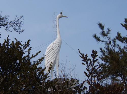
2004 (station established 1987). Active; focal plane 30 m (98 ft); white flash every 4 s. 15 m (49 ft) (?) sculpture of a crane mounted atop a round white concrete tower; the light is atop the bird's head. The Port of Mokpo's photo is at right, another photo is available, and Google has a satellite view. The tower appears taller than its listed height. Located atop a hill on the south side of the entrance to the Yeongsan River estuary, the inner harbor of Mokpo. Accessible only by boat. Site status unknown. KR-3090; Admiralty M4218; NGA 17628.
Madangyeo
Date unknown. Active; focal plane 20 m (66 ft); green flash every 4 s. 24 m (79 ft) round concrete tower. Entire lighthouse is green. No photo available but Google has a satellite view. Located on a shoal in the Yeongsan River. Accessible only by boat. Site open, tower closed. KR-3098.1; Admiralty M4218.15; NGA 17628.8.
Mokpo Wharf No. 1 (Mokponam Hang)
Date unknown. Active; focal plane 10 m (33 ft); green flash every 4 s. 8 m (26 ft) round white metal tower. No photo available but Google has a satellite view. Located on a pier on the north side of Mokpo's South (Yeongsan River) Harbor. Site and tower closed. KR-3097.3; Admiralty M4218.13; NGA 17628.7.
Mokpo Buk Hang (North Harbor) East Breakwater
Date unknown. Active; focal plane 13 m (43 ft); four yellow flashes every 8 s. 10 m (33 ft) hourglass-shaped concrete tower with lantern and gallery. Entire lighthouse is yellow. Google has a street view from the harbor bridge and a satellite view. Located on the east breakwater of the north harbor of Mokpo. Site and tower closed. KR-3078.7; Admiralty M4217.471; NGA 17627.51.
Monghado Light
Monghado Light, Mokpo
Port of Mokpo photo (no longer online)
Mokpo Buk Hang (North Harbor) West Breakwater
Date unknown. Active; focal plane 13 m (43 ft); four yellow flashes every 8 s. 10 m (33 ft) hourglass-shaped concrete tower with lantern and gallery. Entire lighthouse is yellow. Google has a distant street view from the harbor bridge and a satellite view. Located on the east breakwater of the north harbor of Mokpo. Site and tower closed. KR-3078.6; Admiralty M4217.47; NGA 17627.5.
* Mokpo Buk Hang (North Harbor) Southwest Breakwater (2)
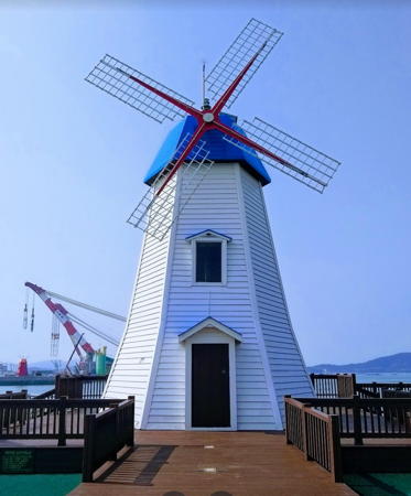
2009. Active; focal plane 16 m (52 ft); red flash every 6 s. 12 m (39 ft) tapered octagonal wood tower in the form of a windmill. Entire lighthouse is red. Kyungmin Park has a 2019 closeup photo, another photo is available, Young Ju Lee has a street view, and Google has a satellite view. Located on the southwest breakwater of the north harbor of Mokpo. Accessible by walking the pier. Site open, tower closed. KR-3078.10; Admiralty M4217.45; NGA 17627.4.
* Mokpo Buk Hang (North Harbor) Northeast Breakwater (2)
2009. Active; focal plane 16 m (52 ft); green flash every 6 s. 12 m (39 ft) tapered octagonal wood tower in the form of a windmill. Entire lighthouse is white. Hun Seok Han has the 2019 closeup photo at right, Park Moo-hee has a 2023 photo, Young Ju Lee has a distant street view, and Google has a satellite view. Located on the northwest breakwater of the north harbor of Mokpo. Accessible by walking the pier. Site open, tower closed. KR-3078.9; Admiralty M4217.455; NGA 17627.3.
Mokpu Buk Hang Detached Breakwater West End
Date unknown. Active; focal plane about 12 m (39 ft); green light, pattern unknown. Approx. 8 m (26 ft) round cylindrical white concrete tower. This light is at the left in a photo of the breakwater, Kim Yong-pal has a view from the wharf, and Google has a satellite view. Located at the west end of a breakwater off the entrance to the north harbor. Accessible only by boat. Site open, tower closed. Admiralty M4217.451; NGA 17626.8.
Mokpu Buk Hang Detached Breakwater East End
Date unknown. Active; focal plane about 12 m (39 ft); yellow light, pattern unknown. Approx. 8 m (26 ft) round cylindrical yellow concrete tower. Park Moo-hee has a 2023 photo, this light is at the right in a photo of the breakwater, and Google has a satellite view. Located at the east end of a breakwater off the entrance to the north harbor. Accessible only by boat. Site open, tower closed. Admiralty M4217.452; NGA 17626.9.
 

Buk Hang Northeast Breakwater Light, Mokpo, February 2019
Google Maps photo by Hun-Seok Han
 

Muan County Lighthouses

Mangun Township Lighthouse
* Tommeon Hang Breakwater
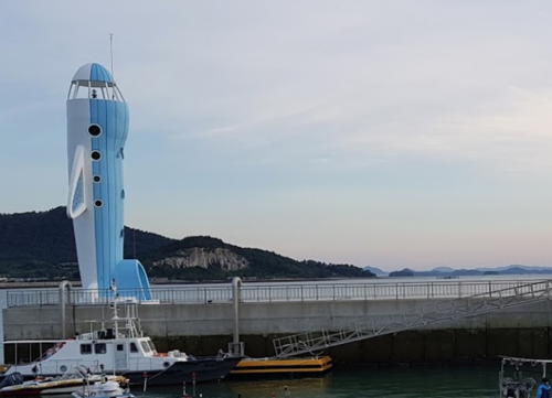
Date unknown. Active; focal plane about 18 m (59 ft); green light, pattern unknown. Approx. 15 m (49 ft) tower in the shape of an airplane standing on its tail; the light is in the cockpit. Lighthouse painted blue. A photo is at right and Google has a satellite view. Located on a pier at the Tommeon harbor near the Muon International Airport. Accessible by walking the pier. Site open, tower closed. Not listed by the Admiralty but charted as active by Navionics.

Hyeongyeong Township Lighthouse
* Woldu Hang Breakwater
Date unknown. Active; focal plane 16 m (52 ft); red flash every 6 s. 11.5 m (37 ft) round concrete tower painted red. Hyunsoo Lee has a photo and Google has a street view and a satellite view. Located on a pier at Woldu facing Hampyeong Man, the bay on the north side of the district. Accessible by walking the pier. Site open, tower closed. KR-3134.7; Admiralty M4209.8.

Yeonggwang County Lighthouses

Yeomsan Township Lighthouse
Mingyedo (Mok-som)
Date unknown. Active; focal plane 24 m (79 ft); white flash every 6 s. 11 m (36 ft) octagonal white concrete tower. Jeasung Park has a very distant drone view and Google has a satellite view. Located on a small island in the channel between the mainland and the Yanggan Peninsula, west of the Chilsan Bridge, in the entrance to Hampyeong Man. Accessible only by boat. Site status unknown. KR-3134.8; Admiralty M4209.6; NGA 17713.5.

Tommeon Hang Light, Mangun District, September 2018
Google Maps photo by najuman
Jeodo
Date unknown. Active; focal plane about 10 m (33 ft); red light, pattern unknown. Approx. 10 m (33 ft) round cylindrical red concrete tower. Jeasung Park has a very distant drone view and Google has a satellite view. Located about 800 m (1/2 mi) south southwest of the Mingyedo light. Accessible only by boat. Site open, tower closed. Admiralty M4209.7.

Nakwol Township (Anmado) Lighthouses
Anmado is an island about 25 km (15 mi) northwest of Yeomsan. The island has a population of about 200 and is accessible by passenger ferry from Hongnong.
Anmado
1958. Active; focal plane 85 m (279 ft); white flash every 10 s. 5 m (16 ft) round white concrete tower. The Korea Maritime News posted a photo (also seen at right) of technicians inspecting the lighthouse and Google has a satellite view. The lighthouse is actually on Hoengdo, a small island off the southwest side of Anmado. Site status unknown. KR-3139; Admiralty M4209; NGA 17716.
Anmado South Point
Date unknown. Active; focal plane about 12 m (39 ft); green flash every 4 s. 12 m (39 ft) round green concrete tower. A distant 2023 view is available and Google has a satellite view. Located in the narrow passage around the south point of Anmado, between Anmado and Udo. Accessible only by boat. KR-3139.1; Admiralty M4208.9.

Anmado Light, Anmado, 2019
Korean Coast Guard photo
* Anma Hang South Breakwater
Date unknown. Active; focal plane 15 m (49 ft); red flash every 5 s. 10 m (33 ft) round concrete tower. Entire lighthouse is red. A 2019 closeup photo, a second photo, a 2020 photo, and another closeup photo (third photo on the page) are available, and Google has a distant satellite view. Located at the end of the south breakwater of Anma harbor. Accessible by walking the pier. Site open, tower closed. KR-3140; Admiralty M4209.2; NGA 17721.
* Anma Hang North Breakwater
Date unknown. Active; focal plane 15 m (49 ft); green flash every 5 s. 10 m (33 ft) round concrete tower. Entire lighthouse is white. A photo of both breakwater lights is available, Byeong-Moon Shin has an aerial view of both breakwater lights, and Google has a distant satellite view. NGA lists this tower erroneously as being red. Located at the end of the north breakwater of Anma harbor. Accessible by walking the pier. Site open, tower closed. KR-3141; Admiralty M4209.4; NGA 17722.
Gamgwagyeo
Date unknown. Active; focal plane 15 m (49 ft); two white flashes every 10 s. 16 m (52 ft) round concrete tower painted black with one red horizontal band. No photo available but Bing has a distant satellite view. Located on a rocky reef about 2 km (1.25 mi) northeast of Anmado. Accessible only by boat. KR-3139.3; Admiralty M4209.1.
Sougakseo
2018. Active; focal plane 12 m (39 ft); two white flashes every 10 s. 12 m (39 ft) round concrete tower painted black with one red horizontal band. No photo available but Google has an indistinct satellite view. Located on an isolated rock about 10 km (6 mi) northeast of Anmado. Accessible only by boat. KR-3139.5; Admiralty M4209.15.

Baeksu Town Lighthouse
* Daesin
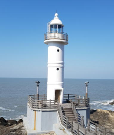
Date unknown. Active; focal plane about 30 m (98 ft); white light, pattern unknown. Approx. 15 m (49 ft) round cylindrical white concrete tower with lantern and gallery. Minam Jung's 2017 photo is seen at right, Lee Woong Jae has a 2018 photo, Daniel Choi has a street view, and Google has a satellite view. The lighthouse is next door to a popular seafood restaurant. Located on a headland about 2.5 km (1.5 mi) south of the entrance to Beopseong harbor. Accessible by road; parking provided. Site open, tower closed. KR-3143.1; Admiralty M4208.3.
* Jeolliseo
2019. Active; focal plane 11 m (36 ft) (?); red flash every 6 s. 11 m (36 ft) round cylindrical red metal tower. A photo is available, Chiyeon Kang has a closeup 2022 street view, and Google has a satellite view. Nhật Vũ's street view dated August 2019 does not show the light. The focal plane must be larger than the tower height. Accessible by walking the pier. Site open, tower closed. Admiralty M4208.05.

Daesin Light, Baeksu, February 2017
Google Maps photo by Minam Jung

Hongnong Town Lighthouses
Beopseongpo (Popsongpo)
Date unknown. Active; focal plane 8 m (26 ft); green flash every 6 s. 14 m (46 ft) octagonal cylindrical concrete tower with gallery, mounted on a concrete pier. Entire lighthouse is green. A nighttime photo is available and Google has a satellite view. Located a short distance offshore on the north side of the entrance to Beopseong harbor. Accessible only by boat. Site open, tower closed. KR-3142; Admiralty M4208.1.
Beopseong (Popsong)
Date unknown. Active; focal plane 70 m (230 ft); white flash every 4 s. 5 m (17 ft) round white concrete tower. A photo is at right, another photo (first photo on the page) is available, and Google has a satellite view. Located on heights north of the entrance to Beopseong harbor. Site status unknown. KR-3143; Admiralty M4208; NGA 17720.
* Gyema (Kyema) Hang Groin (South Breakwater)
Date unknown. Active; focal plane 12 m (39 ft); red flash every 4 s. 8 m (26 ft) octagonal concrete tower. Entire lighthouse is red. Sunghoon Lee has a photo, Sang Yong-i has a 2021 photo, Chi-Yeon Kang has a distant street view from the west breakwater, and Google has a satellite view and a closeup street view. Located at the end of the south breakwater of Gyema, a small port at the northern end of Jeollanam. Accessible by walking the pier. Site open, tower closed. KR-3144; Admiralty M4208.2; NGA 17718.
* Gyema (Kyema) Hang West Breakwater
Date unknown. Active; focal plane 14 m (46 ft); green flash every 5 s. 8 m (26 ft) octagonal concrete tower. Entire lighthouse is white. Sunghoon Lee has a photo, Chi-Yeon Kang has a closeup street view, and Google has a satellite view. Located at the end of the west (main) breakwater of Gyema. Accessible by walking the pier. Site open, tower closed. KR-3145; Admiralty M4208.21; NGA 17718.5.

Information available on lost lighthouses:

Notable faux lighthouses:


Beopseong Light, Hongnong, August 2006
ex-Daum.net Creative Commons photo by rest-of-life

Adjoining pages: North: Buan County | West: Northern Sinan Islands | Southwest: Central Sinan Islands | South: Jindo

Return to the Lighthouse Directory index | Ratings key

Posted January 9, 2008. Lighthouses: 48. Checked and revised April 24, 2024. Site copyright 2024 Russ Rowlett and the University of North Carolina at Chapel Hil