Lighthouses of South Korea: Dangjin and Pyeongtaek

For most of its history Korea was an independent kingdom, or at least an autonomous kingdom under Chinese influence. This came to an end in 1910 when Japan annexed all of Korea. At the end of World War II in 1945 the 38° parallel was established as the dividing line between U.S. and Soviet zones of occupation, and in 1948 separate civil administrations were established in the two halves of the country. The Korean War (1950-53) ended in a draw with the armistice line falling close to the prewar 38° line. The Republic of Korea (ROK), commonly called South Korea (Daehan Minguk in Korean), occupies the Korean peninsula south of the armistice line.

South Korea is divided into nine provinces and eight province-level cities; the provinces are subdivided into counties and cities. This page covers lighthouses of the cities of Seosan and Dangjin in northern Chungcheongnam (Chungnam, or South Chungcheon) Province and the cities of Pyeongtaek, Hwaseong, and Ansan in southern Gyeonggi Province on South Korea's west coast. At the provincial border the ports of Dangjin in Chungcheongnam and Pyeongtaek in Gyeonggi face each other across a common harbor.

In 2000 South Korea adopted a Revised Romanization System to replace systems formerly used in the West. In the Revised System, the word for a lighthouse is deungdae (등대); dan (formerly tan) is a cape, seom (som) or do (to) is an island, am or amseog is a rock, man is a bay, and hang is a harbor. Some place names may be more familiar to Westerners in the spellings of older systems.

Navigational aids in the ROK are regulated by the Ministry of Oceans and Fisheries (MOF). In this area the lights of Dangjin harbor are maintained by the Daesan Regional Oceans and Fisheries Administration and the remaining lights are maintained by the Pyeongtaek Regional Oceans and Fisheries Administration.

ARLHS numbers are from the ARLHS World List of Lights. KR numbers, where available, are from the Korean light list. Admiralty numbers are from volume M of the Admiralty List of Lights & Fog Signals. U.S. NGA List numbers are from Publication 112.

General Sources
Online List of Lights - Korea - Yellow Sea
Photos by various photographers posted by Alexander Trabas.
Navionics Charts
Navigation chart for the South Korean coast.


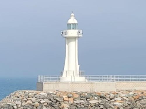
Samgilpo Hang Breakwater Light, Seosan, March 2023
Google Maps photo by Seonggeun Kim
Northern Chungcheongnam Province Lighthouses

Seosan City: Daesan Town Lighthouses
Janganseo (Changanso)
Date unknown. Active; focal plane 18 m (59 ft); two white flashes every 5 s. 21 m (69 ft) round concrete tower, painted with black and red horizontal bands. No photo available and the light is barely visible in Google's satellite view. Located on an isolated rocky islet about 10 km (6 mi) south of the Ijak Islands and 8 km (5 mi) north of the entrance to Daesan Bay. Accessible only by boat. Site open, tower closed. KR-3386; Admiralty M4157; NGA 17896.
Gainseo (Gain Seo)
Date unknown. Active; focal plane 24 m (79 ft); white flash every 5 s. 9.5 m (31 ft) round white fiberglass tower. No photo available but Google has an indistinct satellite view. Located on a reef off the tip of a peninsula on the east side of the entrance to Daesan Bay. Site status unknown. KR-3310; Admiralty M4156.5; NGA 17894.
Heugeodo (Heukeodo)
2003. Active; focal plane 14 m (46 ft); white flash every 6 s. 17 m (56 ft) round white concrete tower with gallery. No photo available but Google has a satellite view. Located at the northern point of an island off Daesan harbor. Accessible only by boat. Site status unknown. KR-3350.5; Admiralty M4156.67.
Sokyeo
Date unknown. Active; focal plane about 15 m (49 ft); two white flashes every 5 s. Approx. 12 m (39 ft) concrete tower painted black with one red horizontal band. No photo available but Google has a satellite view. Located on a reef about 400 m (1/4 mi) north of Bigyeondo. Accessible only by boat. Site open, tower closed. KR-3328.19; Admiralty M4156.95.
* Bigyeongdo (Daesan Hang North Breakwater)
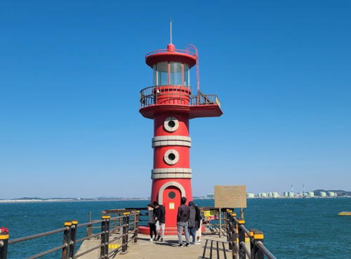
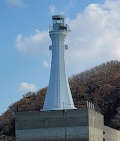
Date unknown. Active; focal plane 26 m (89 ft); green flash every 5 s. 15 m (49 ft) tapered octagonal white concrete tower with lantern and gallery. A 2022 photo is at right, Park Keun-soo has a photo and Google has a satellite view. Located on a pier at the west end of Bigyeongdo, an island northwest of Daesan harbor. Accessible by walking the pier. Site open, tower closed. KR-3360.2; Admiralty M4156.94.
Daesan Hang West Breakwater
Date unknown. Active; focal plane 25 m (82 ft); red flash every 5 s. 15 m (49 ft) red concrete tower. The top of the tower is seen over the roof of a car in Lee Jung Wook's street view and Google has a satellite view. Located at the end of the breakwater opposite the Bigyeondo lighthouse (previous entry). Site status unknown. KR-3360.1; Admiralty M4156.93.
* Samgilpo Hang Breakwater
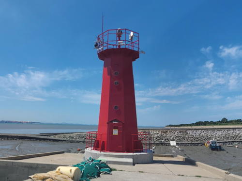
2009. Active; focal plane 14 m (46 ft); red flash every 6 s. 13 m (43 ft) round concrete tower with a decorative lantern and gallery. Entire lighthouse is red. Seonggeun Kim has the 2023 photo at the top of this page, M.C. Han has a 2011 photo, another photo and a more distant photo are available, and Google has a satellite view. Located at the end of the breakwater at Samgilpo, near the eastern end of the Daesan waterfront. Accessible by walking the pier. Site open, tower closed. KR-3360.5; Admiralty M4156.97; NGA 17867.1.

Bigyeongdo Light, Seosan, November 2022
Google Maps photo by ACI

Dangjin City: Seokmun Township Lighthouses
* Daenanjido Breakwater
Date unknown. Active; focal plane 11 m (36 ft); red flash every 6 s. 9 m (30 ft) round hourglass-shaped red concrete tower. Park Mi-kyung has a photo and Google has a satellite view. Located at the end of the breakwater on the east side of Daenanjido, an island off the west end of Dangjin and north of Daesan. Accessible by walking the pier. Site open, tower closed. KR-3306.4; Admiralty M4156.96.
Dangjin (Tangjin) Range Front
Date unknown. Active; focal plane 32 m (105 ft); continuous light, white, red or green depending on direction. 27 m (89 ft) square skeletal tower with lantern and gallery. No photo available but Google has a satellite view. Located on an industrial wharf at Dangjin. Site status unknown. Admiralty M4162.62; NGA 17938.
Dangjin (Tangjin) Range Rear
Date unknown. Active; focal plane 34 m (112 ft); continuous white light. 30 m (98 ft) square west chimney tower of the Dangjin Power Plant. No photo available but Google has a satellite view. Site and tower closed. Admiralty M4162.621; NGA 17938.05.
* Janggo Hang West Breakwater (2)
Date unknown. Active; focal plane about 16 m (52 ft); red flash every 4 s. Approx. 12 m (39 ft) red concrete tower with lantern and gallery. A 2022 photo is available, Eunjung Lee has 2023 view down the pier, and Bing has a satellite view. NGA describes an 8 m (26 ft) post. Located on the west breakwater of a small boat harbor in the Janggo neighborhhod. Accessible by walking the pier. Site open, tower closed. KR-3420.8; Admiralty M4162.76; NGA 17938.4.
* Janggo Hang East Breakwater (2)
Date unknown. Active; focal plane about 16 m (52 ft); green light, pattern unknown. Approx. 12 m (39 ft) white concrete tower with lantern and gallery. Jinhee Bae has the 2022 photo at right, a 2021 photo is at right, and Bing has a satellite view. Located on the west breakwater of a small boat harbor in the Janggo neighborhhod. Accessible by walking the pier. Site open, tower closed. KR-3420.9; Admiralty M4162.765.

Dangjin City: Songsan Township Lighthouse
Seonggumi Hang (?)
2008. Inactive since 2020 and subsequently removed. 10 m (33 ft) round cylindrical concrete tower with lantern and gallery. Entire lighthouse is red. Pyeongtaek MOF has a 2008 photo and Bing has a satellite view, but Google's satellite view confirms the removal. The light was removed due to construction and might be relocated when the project is completed. Formerly located on the breakwater of Seonggumi harbor, at the western end of Dangjin. ex-KR-3445.1; ex-Admiralty M4158.598; NGA 17897.

Janggo Hang East Breakwater Light, Dangjin, April 2022
Google Maps photo by Jinhee Bae

Dangjin City: Songak Township Lighthouse
Bangdo (Pangdo)
Date unknown. Active; focal plane 15 m (49 ft); green flash every 6 s. 16 m (52 ft) round concrete tower. Upper half of the tower painted yellow, lower half black. No photo available but Bing has a satellite view. Located on a rocky islet in the estuary between Daesan and Pyongtaek. Accessible only by boat. Site open, tower closed. KR-3446.5; Admiralty M4158.59; NGA 17898.
#Naedo
Date unknown. Inactive since 2013 and apparently demolished. This was a 30 m (98 ft) square cylindrical skeletal tower with gallery, painted white. No photo available and the tower has disappeared from Google's satellite view. This was a leading light for vessels entering Daesan and Pyongtaek harbors. Formerly located at the west end of the Dangjin waterfront. Site status unknown. Admiralty ex-M4158.64; ex-NGA 17902.
* Godaeri
2006. Active; focal plane 9 m (30 ft); red flash every 4 s. 7 m (23 ft) round concrete tower with lantern and gallery. Lighthouse is red with gray concrete block trim. Yu Min's 2020 photo is at right, Eomnag Hyeon has a photo, Min Jun has a 2019 photo, a 2024 photo is available, and Google has a satellite view. Located on a short pier about 4 km (2.5 mi) east of the Seonggumi lighthouse. Accessible by walking the pier. Site open, tower closed. KR-3448.7; Admiralty M4158.645; NGA 17903.
Godaeri Hang Breakwater
Date unknown. Active; focal plane 19 m (62 ft); two red flashes every 6 s. 12 m (39 ft) round concrete tower with lantern and gallery. Entire lighthouse is red. Lee Il-joo has a view from a nearby park and Google has a satellite view. Located at the end of a curved breakwater enclosing a small boat harbor at Godaeri. May be accessible by walking the pier. Site status unknown. KR-3326.1; Admiralty M4158.648; NGA 17904.
 

Godaeri Light, Dangjin, October 2020
Google Maps photo by Yu Min
Hanjingak
2006. Active; focal plane 15 m (49 ft); quick-flashing white light. 17 m (56 ft) round concrete tower, upper half painted black and lower half yellow. Hyunsik Kim has a 2022 photo and Google has a satellite view. Located on a reef opposite Pyongtaek harbor. Accessible only by boat. Site status unknown. KR-3461.9; Admiralty M4158.86; NGA 17912.5.
Hanjin
Date unknown. Active; focal plane 14 m (49 ft); quick-flashing white light. 18 m (59 ft) round concrete tower, upper half painted black and lower half yellow. No photo available but Google has a satellite view. Located on a reef opposite Pyeongtaek harbor. Accessible only by boat. Site status unknown. KR-3461.8; Admiralty M4158.87; NGA 17912.6.
Yeongam (Yong-am) West (Hanjin-ri)
2012. Active; focal plane 9 m (30 ft); three quick white flashes every 10 s. 16 m (52 ft) round concrete tower with double gallery, mounted on a round concrete pier. Lighthouse painted black with one yellow horizontal band. Pyeongtang MOF has a photo and Google has a satellite view. Located on what is probably a spoil island about 2.5 km (1.5 mi) west of the Seohae bridge. Accessible only by boat. Site status unknown. KR-3464.4; Admiralty M4158.963; NGA 17912.7.
Yeongam (Yong-am) East
2005. Active; focal plane 16 m (52 ft); nine quick white flashes every 15 s. 14 m (46 ft) round concrete tower with double gallery, mounted on a round concrete pier. Lighthouse painted yellow with one black horizontal band. A closeup photo is available and Google has a satellite view. Located on what is probably a spoil island about 2.5 km (1.5 mi) northwest of the Seohae bridge. Accessible only by boat. Site status unknown. KR-3464.7; Admiralty M4158.96; NGA 17912.8.
Haengdamdo
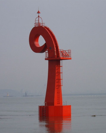
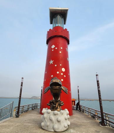
2006. Active; focal plane 12 m (39 ft); red flash every 6 s. 17 m (56 ft) steel sculpture; the tower is curved gracefully forming a loop at the top. Entire structure is red. A closeup photo is at right, another closeup is available, and Bing has a satellite view. From a distance, this remarkable light looks like the tail of a diving sea monster (or perhaps a mermaid). In fact it is sculpture of the letter "P" for Pyeongtaek. Located on an island just north of the west (Dangjin) end of the Seohae bridge. Accessible only by boat. Site status unknown. KR-3466.9; Admiralty M4158.965; NGA 17913.1.
Haengdamdo Light
Haengdamdo Light, Dangjin; unattributed photo
probably by Pyeongtaek Regional Oceans and Fisheries Office

Dangjin City: Sinpyeong Township Lighthouse
* Cargo Terminal West Wharf
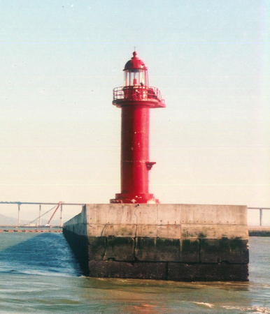
Date unknown. Active; focal plane 13 m (43 ft); red flash every 4 s. 11 m (36 ft) round concrete tower with lantern and gallery, painted red. A photo is at right and Google has a satellite view. NGA calls this the Pyeongtaek North Breakwater Light. It is part of the Pyeongtaek Harbor but it is physically located within Dangjin City limits. Located at the end of a pier extending from an island terminal in the middle of the estuary. Accessible by walking the pier. Site open, tower closed. KR-3477; Admiralty M4158.95; NGA 17913.

Southern Gyeonggi Province Lighthouses

Pyeongtaek City: Poseung Town Lighthouses
Pyeongtaek Inner Harbor East Breakwater
Date unknown. Active; focal plane 12 m (39 ft); red light, pattern unknown. 7 m (23 ft) round concrete tower with lantern and gallery, painted red. No photo available but Google has a satellite view. Located on a breakwater on the east side of the entrance to the inner harbor, east of the Seohae Bridge. Site status unknown. Admiralty M4158.973.
Pyeongtaek Inner Harbor West Breakwater
Date unknown. Active; focal plane 12 m (39 ft); green light, pattern unknown. 7 m (23 ft) round concrete tower with lantern and gallery, painted white. No photo available but Google has a satellite view. Located on a breakwater on the west side of the entrance to the inner harbor, east of the Seohae Bridge. Site status unknown. Admiralty M4158.972.
Pyeongtaek East Docks East Breakwater
Date unknown. Active; focal plane 12 m (39 ft); four red flashes every 8 s. 7 m (23 ft) round concrete tower with lantern and gallery, painted red. No photo available but Google has a satellite view. Located on a breakwater on the east side of the entrance to one of the harbor basins of Pyeongtaek. Site status unknown. KR-3490; Admiralty M4158.91; NGA 17912.4.
Pyeongtaek East Docks West Breakwater
Date unknown. Active; focal plane 12 m (39 ft); four green flashes every 8 s. 7 m (23 ft) round concrete tower with lantern and gallery, painted white. No photo available but Google has a satellite view. Located on a breakwater on the west side of the entrance to one of the harbor basins of Pyeongtaek. Site status unknown. KR-3489; Admiralty M4158.9; NGA 17912.3.

Pyeongtaek Cargo Terminal West Wharf Light, Dangjin
Pyeongtaek City government photo
Pyeongtaek West Docks East Breakwater
Date unknown. Active; focal plane 12 m (39 ft); two red flashes every 6 s. 7 m (23 ft) round concrete tower with lantern and gallery, painted red. No photo available but Google has a satellite view. Located on a breakwater on the east side of the entrance to one of the harbor basins of Pyeongtaek. Site status unknown. KR-3492; Admiralty M4158.93; NGA 17912.2.
Pyeongtaek West Docks West Breakwater
Date unknown. Active; focal plane 12 m (39 ft); two green flashes every 6 s. 7 m (23 ft) round concrete tower with lantern and gallery, painted white. No photo available but Google has a satellite view. Located on a breakwater on the west side of the entrance to one of the harbor basins of Pyeongtaek. Site status unknown. KR-3491; Admiralty M4158.92; NGA 17912.1.
Asan Myoji Breakwater
2005. Active; focal plane 10 m (33 ft); yellow flash every 4 s. 9 m (30 ft) round concrete tower with lantern and gallery, painted yellow. No photo available but Google has a satellite view. Located on a pier at the natural gas terminal just west of the West Docks. Site status unknown. KR-3488; Admiralty M4158.8; NGA 17912.

Hwaseong City: Ujeong Town Lighthouses
* Seokcheon Hang East Breakwater
Date unknown. Active; focal plane 14 m (43 ft); four red flashes every 8 s. 9 m (30 ft) octagonal red steel tower. A street view is at right and Google has a satellite view. Located on the east breakwater of a small boat harbor near the Kia automobile assembly plant on the north side of the entrance to Pyeongtaek harbor. Accessible by walking the pier. Site open, tower closed. KR-3473; Admiralty M4158.58.
Maehyangni
2007. Active; focal plane 18 m (56 ft); green flash every 6 s. 16 m (52 ft) square cylindrical skeletal tower, painted green. Oh-Sung Kwon has a photo and Google has a satellite view. Located at the end of long breakwater at the entrance to Pyeongtaek harbor. The breakwater is awash at high tide and does not appear to be walkable. Site and tower closed. KR-3446.8; Admiralty M4158.57; NGA 17897.5.

Seokcheon Hang East Breakwater Light, Hwaseong, September 2022
Google Maps street view by Vivian
Gungpyeongdo
Date unknown. Active; focal plane 15 m (49 ft); green flash every 6 s. Approx. 12 m (39 ft) white concrete tower with lantern and gallery. No photo available but Google has a satellite view. The breakwater was extended about 100 m (328 ft) in 2019-20 and the lighthouse was relocated. Located on a breakwater on the south side of Gungpyeong, a small harbor at the north side of the entrance to Daesan and Pyeongtaek. May be accessible by walking the pier. Site status unknown. KR-3492.10; Admiralty M4158.988.
* Gungpyeong Hang North Breakwater
Date unknown. Active; focal plane 17 m (56 ft); two yellow flashes every 6 s. 11 m (36 ft) octagonal yellow (formerly white) concrete tower. A 2024 closeup shows the yellow daymark, Lim Sung Taek has a closeup 2020 photo and Google has a satellite view. Located on the north breakwater at Gungpyeong. Accessible by walking the pier. Site open, tower closed. KR-3493.6; Admiralty M4158.992.
Gukhwado South
2006. Active; focal plane 14 m (46 ft); six quick white flashes followed by one long white flash every 15 s. 19 m (62 ft) round concrete tower, upper half painted yellow and lower half black. A street view from shore is available and Bing has a satellite view.Gukhwado is an island in the entrance to Dangjin and Pyeongtaek harbors, south of Ippado and close to the Dangjin shore. Located on a reef off the south end of Gukhwado. Accessible only by boat. Site status unknown. KR-3420.5; Admiralty M4162.72; NGA 17938.3.
* Gukhwado Breakwater
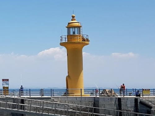
Date unknown. Active; focal plane 12 m (39 ft); yellow flash every 6 s. 12 m (39 ft) round cylindrical concrete tower with lantern and gallery, painted yellow (formerly red) with white trim. Yousang Tak has the photo seen at right, Lee Seong-gun a photo, and Google has a satellite view. Located at the end of a breakwater pier at the northeast end of Gukhwado. Accessible by walking the pier. Site open, tower closed. KR-3420.7; Admiralty M4162.75; NGA 17938.35.

Breakwater Light, Gukhwado, June 2017
Google Maps photo by Yousang Tak
Gukhwado North
2006. Active; focal plane 16 m (52 ft); quick-flashing white light. 11 m (36 ft) round concrete tower, upper half painted black and lower half yellow. A closeup (halfway down the page) is available and Google has an indistinct satellite view. Located at the north end of a smaller island off the north end of Gukhwado. Accessible only by boat. Site status unknown. KR-3420.6; Admiralty M4162.73 (ex-M4162.7).
Haksanseo
Date unknown. Active; focal plane 15 m (49 ft); two red flashes every 6 s. 19 m (62 ft) round concrete tower, upper half painted black and lower half yellow. Two photos (second and fourth photos on the page) are available and Google has a satellite view. Located about 800 m (1/2 mi) northwest of Gukhwado. Accessible only by boat. Site open, tower closed. KR-3425; Admiralty M4160; NGA 17926.
Ippado
2007. Active; focal plane 119 m (390 ft); white flash every 10 s. 26 m (85 ft) round cylindrical concrete tower with lantern and gallery. Entire lighthouse is white. A 2022 photo is at right, Hyunjung Park has a 2021 photo, and Google has a satellite view. Ippado is an island in the entrance to Dangjin and Pyeongtaek harbors. Located at the highest point of the island. Accessible only by boat. Site status unknown. Admiralty M4159.8; NGA 17929.5.
Dorido (Torido)
1969. Active; focal plane 58 m (190 ft); white flash every 6 s. 9 m (30 ft) octagonal white concrete tower with lantern and gallery. Lighthouse painted white, lantern dome red. A closeup photo (2/3 the way down the page) and a more distant view (1/3 the way down the page) are available and Google has a satellite view. Located on a small island off the north side of the entrance to Daesan and Pyeongtaek. Accessible only by boat. Site status unknown. KR-3422; Admiralty M4159; NGA 17928.
Gamjungseo
Date unknown. Active; focal plane 12 m (39 ft); nine quick white flashes every 15 s. 17 m (56 ft) round concrete tower painted yellow with a black horizontal band. No photo available but Google has a satellite view. Located on a reef about 800 m (1/2 mi) northwest of the Dorido lighthouse. Accessible only by boat. Site open, tower closed. KR-3422.7; Admiralty M4159.1.

Ippado Light, Pyeongtaek, April 2022
Google Maps photo by 크라쿠라

Ansan City: Pungdo Neighborhood Lighthouses
These lights are located just off the entrance to Dangjin harbor, but they are administered by Ansan City in Gyeonggi Province. The mainland portion of Ansan is north of Hwaseong.

*
Pungdo
Date unknown. Active; focal plane 38 m (125 ft); white flash every 6 s. 10 m (33 ft) octagonal white concrete tower with gallery. A 2023 closeup photo and a view from a nearby beach are available and Google has a heavily shadowed satellite view. Located on the northern tip of Pungdo, an inhabited island about 20 km (13 mi) northwest of Daesan. Site open, tower closed. KR-3402; Admiralty M4158.3; NGA 17936.
* Pungdo Hang North Breakwater
2007. Active; focal plane 15 m (49 ft); two red flashes every 6 s. 9 m (30 ft) round red concrete tower with gallery. Lim Sungnam has a photo showing both breakwater lighthouses and Google has a satellite view. Located on the main breakwater of Pungdo. Accessible by walking the pier. Site open, tower closed. Admiralty M4158.4; NGA 17936.3.
* Pungdo Hang South Breakwater
2012. Active; focal plane 11 m (36 ft); two green flashes every 6 s. 10 m (33 ft) round white concrete tower with gallery. A photo (a little over halfway down the page) is available, Lim Sungnam has a photo showing both breakwater lighthouses and Google has a satellite view. Located on the short south breakwater of Pungdo. Accessible by walking the pier. Site open, tower closed. KR-3308.4; Admiralty M4158.45; NGA 17936.5.
Mallyukdo (Malyukdo, Maryukdo)
Date unknown. Active; focal plane 42 m (138 ft); white flash every 5 s. 9 m (30 ft) round white fiberglass tower. Kang Myung-guk has a distant view, a similar distant view (halfway down the page) is available, and Google has a satellite view. Located on an island marking the north end of a reef about 5 km (3 mi) east of Pungdo. Accessible only by boat. Site status unknown. KR-3403; Admiralty M4161; NGA 17937.

Hwaseong City: Seosin Township Lighthouses
* Jebudo Hang
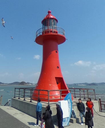
2007. Active; focal plane 15 m (49 ft); red flash every 4 s. 9 m (30 ft) round tapered concrete tower with lantern and gallery. Entire lighthouse is red. A photo is at right, Donghoo Kim has a 2020 photo, Moon Jae-ho has a drone view, and Google has a closeup street view and a satellite view. Jebudo is an island off Hwaseong, connected to the city by a long causeway. Located at the northern end of the island. Accessible by walking the pier. Site open, tower closed. KR-3422.3; Admiralty M4162.82; NGA 17929.
* Jeongok Hang
2009. Active; focal plane 17 m (56 ft); two red flashes every 6 s. 11 m (36 ft) round cylindrical concrete tower with lantern and gallery. Lighthouse painted red; a 2024 photo shows it decorated artistically. A 2020 closeup photo is available but Google has a satellite view. Located at the end of the west pier of Jeongok harbor. Accessible by walking the pier. Site open, tower closed. KR-3422.8; Admiralty M4162.77; NGA 17931.

Ansan City: Seongam Neighborhood Lighthouses
* Tando Hang (Jeongok Hang West Side)
Date unknown. Active; focal plane 21 m (69 ft); two green flashes every 6 s. 12 m (39 ft) round cylindrical concrete tower. Entire lighthouse is white. A 2021 closeup photo is available and Google has a distant satellite view. Located at the end of a quay on the west side of Jeongok harbor. Accessible by walking the pier. Site open, tower closed. KR-3422.9; Admiralty M4162.79; NGA 17930.

Jebudo Hang Light, Hwaseong, April 2017
Google Maps photo by 카푸리또
*** Haeseodo (Nueseom, Silkworm Island)
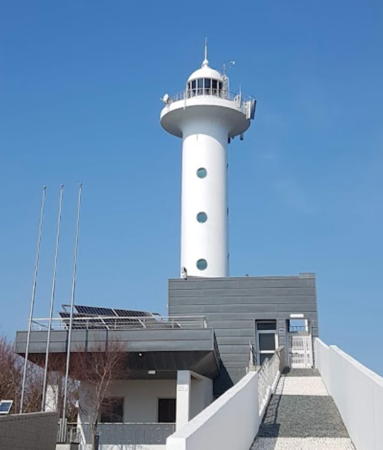
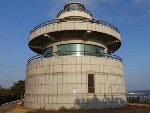
Date unknown. Active; focal plane 45 m (148 ft); two white flashes every 6 s. 14 m (46 ft) round concrete tower with lantern and gallery, centered on a round 2-story museum building. There is an observation deck atop the museum. A 2022 photo is at right, B.S. Cho has a 2020 photo, Yeong Cheolgak has a 2021 closeup, Hong Jin-hyun has a closeup street view from the museum's observation deck, and Google has a satellite view. Located on Haeseodo (also called Nueseom, or Silkworm Island), a small island just off Jeongok. Transportation from the city is available. Site open, museum open daily except Mondays and certain national holidays; the observation deck is open, but the light tower is closed. KR-3422.5; Admiralty M4162.8.

Ansan City: Danwon Neighborhood Lighthouse
Haengnanggok
Date unknown. Active; focal plane 15 m (49 ft); white flash every 4 s. 10 m (33 ft) octagonal white concrete tower. Kim Bun-seon has a closeup photo and Google has a satellite view. Located at the end of a long jetty projecting from the southern tip of Jindu island. Site status unknown. KR-3496.1; Admiralty M4162.9.

Ansan City: Daebubuk Neighborhood Lighthouse
* Tagubongdo
Date unknown. Active; focal plane 15 m (49 ft); red flash every 5 s. 17 m (56 ft) round cylindrical concrete tower. Entire lighthouse is red. Myeongcheol Baek has a photo and Google has a street view and a satellite view. Located just off a sharp promontory at the northwestern corner of Jindi island, marking the south side of the entrance to the Incheon New Port. Visible closely from a popular observation platform. Site open, tower closed. KR-3501.1; Admiralty M4164.4; NGA 17938.5.

Haeseodo Light, Ansan, December 2022
Google Maps photo by 서명수

Information available on lost lighthouses:

Notable faux lighthouses:

Adjoining pages: North: South Ongjin Islands | South: Taean

Return to the Lighthouse Directory index | Ratings key

Posted February 4, 2008. Checked and revised July 1, 2024. Lighthouses: 51. Site copyright 2024 Russ Rowlett and the University of North Carolina at Chapel Hill.