Lighthouses of South Korea: South Ongjin Islands

For most of its history Korea was an independent kingdom, or at least an autonomous kingdom under Chinese influence. This came to an end in 1910 when Japan annexed all of Korea. At the end of World War II in 1945 the 38° parallel was established as the dividing line between U.S. and Soviet zones of occupation, and in 1948 separate civil administrations were established in the two halves of the country. The Korean War (1950-53) ended in a draw with the armistice line falling close to the prewar 38° line. The Republic of Korea (ROK), commonly called South Korea (Daehan Minguk in Korean), occupies the Korean peninsula south of the armistice line.

South Korea is divided into nine provinces and eight province-level cities; the provinces are subdivided into counties and cities. This page covers lighthouses of islands lying southwest of Incheon off South Korea's northwest coast, including the three townships of Deokjeok, Jawol, and Yeongheung in Ongjin County. The county is administered as part of Incheon City. Ongjin County has four additional island townships, one close to Incheon and three on remote islands to the west; their lighthouses are described on the Incheon Area page.

In 2000 South Korea adopted a Revised Romanization System to replace systems formerly used in the West. In the Revised System, the word for a lighthouse is deungdae (등대); dan (formerly tan) is a cape, seom (som) or do (to) is an island, am or amseog is a rock, man is a bay, and hang is a harbor. Some place names may be more familiar to Westerners in the spellings of older systems.

Navigational aids in the ROK are regulated by the Ministry of Oceans and Fisheries (MOF). In this area the lights are maintained by the Incheon Regional Office of Oceans and Fisheries. MOF also operates the major coastal lights but management of harbor lighthouses is in the hands of local port authorities.

ARLHS numbers are from the ARLHS World List of Lights. KR numbers, where available, are from the Korean light list. Admiralty numbers are from volume M of the Admiralty List of Lights & Fog Signals. U.S. NGA

General Sources
Online List of Lights - Korea - Yellow Sea
Photos by various photographers posted by Alexander Trabas.
Navionics Charts
Navigation chart for the islands.

Sunmido Light
Seonmido (Sunmido) Light, Deokjeok
Port of Incheon photo
Deokjeok Township Lighthouses

Uldo Islands Lighthouses
Uldo is one of the outermost of the Incheon Bay islands, about 105 km (65 mi) southwest of Incheon.

Mokdeokdo (Moktok-do, Moktok To)
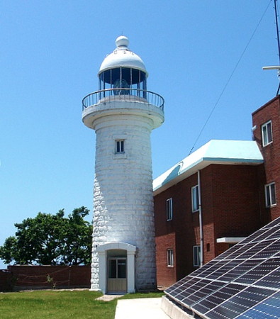
1909. Active; focal plane 66 m (217 ft); two flashes every 15 s, a white flash followed 3 s later by a red flash. 6 m (20 ft) round concrete tower with lantern and gallery, painted white. Several 1-story keeper's houses and other light station buildings. A photo is at right and a closeup is available, but Google has only a fuzzy satellite view of the island. This historic lighthouse warns vessels approaching Incheon to avoid the rocks and islets off the coast of Chungcheongnam. It was upgraded with a powerful new light in 2006. Mokdeokdo is the outermost of the Incheon Bay islands, about 120 km (75 mi) southwest of Incheon. Located on a small island about 15 km ( 9 mi) southwest of Uldo and 40 km (25 mi) north northwest of Uihang. Accessible only by boat. Site status unknown. ARLHS SKR-045; KR-3304; Admiralty M4152; NGA 17856.
Banseo (Panso) (2)
2007 (station establishment date unknown). Active; focal plane 16 m (52 ft); two white flashes every 10 s. 23 m (75 ft) tower, painted black with one red horizontal band. No photo available.and neither reef nor light is shown on Google's satellite view. Located on a rock about 8 km (5 mi) northeast of the Mokdeokdo lighthouse. Accessible only by boat. Site open, tower closed. KR-3305.5; Admiralty M4151; NGA 17856.5.

Mokdeokdo Light, Deokjeok
Korean National Lighthouse Museum photo
Uldo (Ul To)
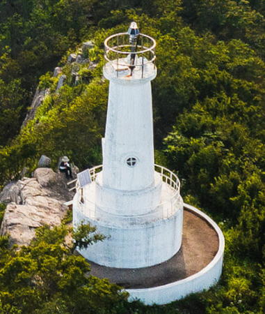
Date unknown. Active; focal plane 231 m (758 ft); white flash every 6 s. 9 m (30 ft) round white concrete tower mounted on a round concrete base. Min Joong Kim's 2023 drone view is at right, a photo is available, Kim Byeon-sun has a closeup photo, and Google has an indistinct satellite view. Located on the highest point of the island. Accessible by a challenging hiking trail. Site open, tower closed. KR-3306; Admiralty M4155; NGA 17892.
* Uldo Hang West Breakwater
2004. Active; focal plane 15 m (49 ft); red flash every 6 s. 11 m (36 ft) round cylindrical concrete tower, painted red. Park Byung-geun has a view of the two breakwater lights under a rainbow, a photo (halfway down the page) of the two lights is available, and Bing has a satellite view. Located at the end of the west breakwater of Uldo harbor, on the north side of the island. Accessible by walking the pier. Site open, tower closed. KR-3306.2; Admiralty M4155.2.
Uldo Hang East Breakwater
Date unknown. Active; focal plane 15 m (49 ft); green flash every 6 s. 11 m (36 ft) round cylindrical concrete tower, painted white. Park Byung-geun has a view of the two breakwater lights under a rainbow, a photo (halfway down the page) of the two lights is available, and Bing has a satellite view. Located on the detached east breakwater of Uldo harbor. Accessible only by boat. Site open, tower closed. KR-3306.3; Admiralty M4155.3.
Deungdaeyeo (Uldo North, Chi-do)
Date unknown. Active; focal plane 15 m (49 ft); two white flashes every 5 s. 24 m (79 ft) tower, painted black with one red horizontal band. A black-and-white photo is available and the light casts a long shadow in Google's satellite view. Located on a rock off the northwestern tip of Uldo. Accessible only by boat. Site open, tower closed. KR-3306.5; Admiralty M4155.1; NGA 17858.
Jido South
2007. Active; focal plane 12 m (39 ft); six quick white flashes followed by one long white flash every 15 s. 20 m (66 ft) round concrete tower, upper half painted yellow, lower half black. No photo available but Google has a distant satellite view. Located on a reef about 1 km (0.6 mi) south of Jido, an island north of Uldo. Accessible only by boat. Site open, tower closed. KR-3306.6; Admiralty M4155.35.
Baguyeo
Date unknown. Active; focal plane 19 m (62 ft); three quick white flashes every 10 s. 21 m (69 ft) round concrete tower painted black with one yellow horizontal band. No photo available but Google has an indistinct satellite view. Located at the southern tip of a small island off the east side of Baegado, the largest and westernmost of the Uldo island group. Accessible only by boat. Site open, tower closed. KR-3306.7; Admiralty M4155.37.

Uldo Light, DeokjeokAugust 2023
Google Maps photo by Min Joong Kim

Seungap, Gakheul, and Gureop Islands Lighthouses
These are small islands north of the Uldo group and south of Deokjeokdo.
Uduam (Udu-am)
2001. Active; focal plane 16 m (52 ft); two white flashes every 10 s. 16 m (52 ft) tower, painted black with one red horizontal band. No photo available but the light is not shown in Google's satellite view. Located on a rock about 5 km (3 mi) northeast of Uldo and 2 km (1.25 mi) south of Seungapdo. Accessible only by boat. Site open, tower closed. KR-3308.5; Admiralty M4149.3; NGA 17895.
Seungabdo (Seongab Do, Son'gap Do)
Date unknown. Active; focal plane 50 m (164 ft); white flash every 5 s. 9 m (30 ft) white concrete tower. No photo available but Google has a distant satellite view. Located on a promontory on the east coast of Seunggapdo. Site status unknown. KR-3308; Admiralty M4155.6; NGA 18044.
Mineotan (Minotan)
2001. Active; focal plane 13 m (43 ft); two white flashes every 10 s. 8 m (26 ft) round cylindrical concrete tower with gallery, painted black with one red horizontal band. No photo available and Google's satellite view does not show the tower. Located on an isolated rock about 4 km (2.5 mi) northwest of Baegado. Accessible only by boat. Site open, tower closed. KR-3362; Admiralty M4150; NGA 17920.
Gakheuldo (Kakhul Do) South
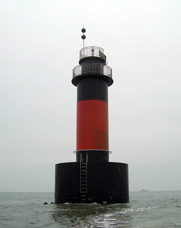
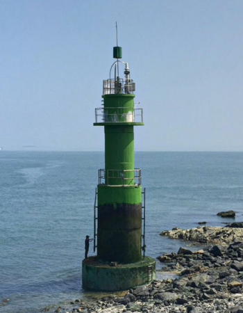
2010. Active; focal plane 17 m (56 ft); two white flashes every 5 s. 20 m (66 ft) round cylindrical concrete tower with gallery, painted black with one red horizontal band, mounted on a round concrete pier. A closeup photo is at right and Bing has a satellite view. Located about 400 m (1/4 mi) off the south point of Gakheuldo, a small island about 15 km (9 mi) southwest of Deokjeokdo. Accessible only by boat. Site open, tower closed. KR-3606.8; Admiralty M4155.5.
Gakheuldo (Kakhul Do)
Date unknown. Active; focal plane 34 m (112 ft); white flash every 6 s. 7 m (23 ft) round white concrete tower. No photo available but Google has a distant satellite view. Located on a small island off the southern tip of Gakheuldo. Accessible only by boat. Site open, tower closed. KR-3661; Admiralty M4155.4; NGA 17924.
Jangtan
Date unknown. Active; focal plane about 15 m (49 ft); white light, pattern unknown. Approx. 15 m (49 ft) ound cylindrical concrete tower with gallery, painted black with one red horizontal band. No photo available but Bing has a satellite view. Located on a reef about 3.2 km (2 mi) west of Gakheuldo. Accessible only by boat. Site open, tower closed. KR-3661.1; Admiralty M4155.52.
Gakheuldo Light
Gakheuldo South Light, April 2011
Port of Incheon news photo
Gureopdo (Guleopdo)
Date unknown. Active; focal plane about 12 m (39 ft); green light, pattern unknown. Approx. 12 m (39 ft) concrete tower painted green. No photo available but Google has a satellite view. Located just off the southeast side of Gureopdo about 8 km (5 mi) northwest of Gakheuldo. Accessible only by boat. Site open, tower closed. KR-3362.3; Admiralty M4149.7.

Deokjeokdo Area Lighthouses
The largest of the southern Ongjin Islands, Deokjeokdo is located 70 km (43 mi) southwest of Incheon. The island is about 6 km (3.6 mi) long, and at its eastern end it is connected by a bridge to Soyado, a companion island about 4 km (2.5 mi) long. The combined population of the two islands about 3500.

South Deokjeokdo
Date unknown. Active; focal plane 14 m (46 ft); three green flashes every 7 s. 10 m (66 ft) round concrete tower, painted green. Korean Nature TV has a distant view and Google has a satellite view. Located about 200 m (220 yd) offshore near the southernmost point of Deokjeokdo. Accessible only by boat. Site open, tower closed. KR-3366.8; Admiralty M4149.15; NGA 18049.2.
Gamjeungtan
2006. Active; focal plane 13 m (43 ft); two white flashes every 5 s. 16 m (52 ft) round concrete tower, painted with black with one red horizontal band. No photo available but Bing has an indistinct satellite view. Located about 3 km (2 mi) off the south coast of Deokjeokdo. Accessible only by boat. Site open, tower closed. Admiralty M4149.25; NGA 18049.1.
South Seopori (Deokjeokdo Southwest, Tokchok Putni South)
Date unknown. Active; focal plane 13m (43 ft); two white flashes every 10 s. 18 m (59 ft) round tower, painted black with one red horizontal band. A distant view (3/4 the way down the page) is available and Bing has a satellite view. Located on a shoal a short distance off the southwestern point of Deokjeokdo. Accessible only by boat. Site open, tower closed. Admiralty M4149.2; NGA 18049.
Dantan
2022. Active; focal plane 19 m (62 ft); two white flashes every 10 s. 17 m (56 ft) round concrete tower, painted with black with one red horizontal band. No photo available but Google has a satellite view. Located on a rocky reef off the northwest point of Deokjeokdo. Accessible only by boat. Site open, tower closed. KR- 3365.1; Admiralty M4148.5.
Seonmido (Sunmido, Sonmi Do) (2)
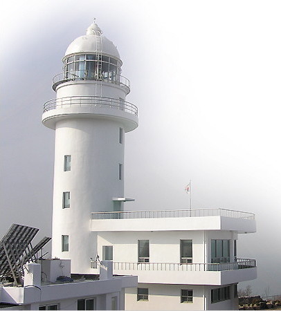
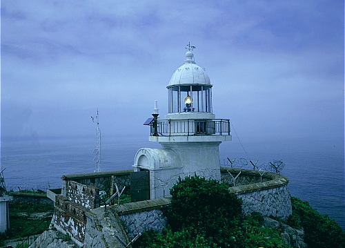
2003 (station established 1934). Active; focal plane 172 m (564 ft); white flash every 12 s. 19.5 m (64 ft) round cylindrical concrete tower with lantern and gallery attached to a 2-story concrete staff building. Lighthouse painted white. Additional keeper's houses and other light station buildings. A photo is at the top of this page, additional photos (halfway down the page) are available, and Google has a good satellite view. This is the highest lighthouse in South Korea. The original 9.5 m (31 ft) lighthouse has been demolished. This lighthouse is the landfall light for Incheon, the largest port of Korea's west coast. Located at the western tip of Seonmido (Sunmido), an island off the northwestern corner of the much larger island of Deokjeokdo. Accessible only by boat and a hiking trail. Site open, and the tower may be open as well. KR-3363; Admiralty M4148; NGA 18040.
* Deokjeok Bukri (North) Breakwater (2)
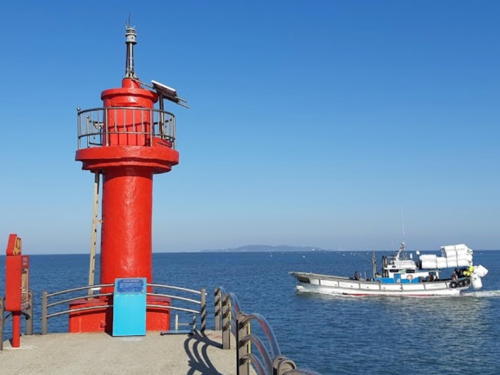
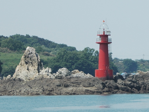
Date unknown (station established 1964). Active; focal plane 11 m (36 ft); red flash every 4 s. 7 m (23 ft) round cylindrical concrete tower mounted on a square concrete base. Entire lighthouse is red. Kim Tae Young has the 2019 closeup photo seen at right, another closeup photo (first photo on the page) is available, and Google has a distant satellite view. Located on the north breakwater of Deokjeokdo harbor, on the northeast side of the island. Accessible by walking the pier. Site open, tower closed. KR-3365; Admiralty M4149; NGA 18048.

North Breakwater Light, Deokjeokdo, March 2019
Google Maps photo by Kim Tae Young
Ungam (Dohang Sudo)
Date unknown. Active; focal plane 15 m (49 ft); two red flashes every 6 s. 16 m (52 ft) round concrete tower, painted red. A photo is at right, a portfolio of photos is available, Heeyong Yoo has a distant view, and Bing has a satellite view. Located off the eastern tip of Deokjeokdo, marking the entrance to a narrow inlet between that island and the neighboring island of Soyado. Accessible only by boat. Site open, tower closed. KR-3164.1; Admiralty M4149.1; NGA 18051.
Soyari
Date unknown. Active; focal plane 12 m (39 ft); red flash every 4 s. 12 m (39 ft) round concrete tower, painted red. This light is on the left in Bryan Word's photo of the Soyado Bridge and Google has a sea view and a satellite view. Located on the south side of the bridge between Soyado and Deokjeokdo. Accessible only by boat. Site open, tower closed. KR-3367; Admiralty M4149.4; NGA 18050.
Jilli
Date unknown. Active; focal plane about 12 m (39 ft); three quick white flashes every 10 s. Approx. 12 m (39 ft) concrete tower painted black with one yellow horizontal band. This light is on the right in Bryan Word's photo of the Soyado Bridge and Google has a sea view and a satellite view. Located about 200 m (220 yd) west of the Soyari light. Accessible only by boat. Site open, tower closed. KR-3367.1; Admiralty M4149.5.
Soyado
Date unknown. Active; focal plane 24 m (79 ft); white flash every 4 s. 10 m (33 ft) octagonal cylindrical white concrete tower. A photo (third photo on the page) is available and Google has a satellite view of the station. This light and the Dongbaekdo Light (next entry) frame a passage through the islands for ships approaching Incheon. Located on the southeastern tip of Soyado. Site status unknown. Admiralty M4168.5; NGA 18052.

Ungam Light, April 2012
ex-Panoramio photo copyright plumgarden; used by permission

Jawol Township Lighthouses

Ijak Islands Lighthouses
This is a group of three main islands (Soijakdo, Daeijakdo, and Seungbong) and several small islands lying southeast of Daekjeokdo and Soyado.
Dongbaekdo (Tongbaekdo)
Date unknown. Active; focal plane 34 m (112 ft); 13 m (43 ft) octagonal cylindrical white concrete tower with gallery. A photo is available and Google has a satellite view. This light and the Soyado Light (previous entry) frame a passage through the islands for ships approaching Incheon. Located atop a small island off the northwestern end of Soijakdo. Accessible only by boat. Site status unknown. KR-3369; Admiralty M4168; NGA 18056.
Ijakdo (Daeijakdo, Ijak To) (2)
Date unknown. Active; focal plane 15 m (49 ft); green flash every 4 s. 14 m (46 ft) round concrete tower, painted green. Shim JaeHee's photo is at right, another photo is available (halfway down the page), Cheonsu Kim has a very distant view, and Google also has a satellite view. An older, much smaller light stood next to the current light, but the smaller tower was removed sometime in 2009-10. Located on the northwestern tip of Daeijakdo. Accessible only by boat. Site status unknown. KR-3373; Admiralty M4170; NGA 18060.
Gwangyeo (Kwangyo)
Date unknown. Active; focal plane 13 m (43 ft); red flash every 5 s. 16 m (52 ft) round concrete tower, painted red. A 2010 photo (seventh photo on the page) and a distant view are available and Google has a satellite view. Located on an islet about 4 km (2.5 mi) northwest of Budo. Accessible only by boat. Site open, tower closed. KR-3373.4; Admiralty M4170.4; NGA 18062.
Beosapcho (Haejeonseo, Haejonso)
Date unknown. Active; focal plane 12 m (39 ft); two white flashes every 10 s. 13 m (43 ft) round tower, painted black with one red horizontal band. No photo available but Google has a satellite view. Located on a reef about 1 km (0.6 mi) north of Seungbong. Accessible only by boat. Site open, tower closed. KR-3494; Admiralty M4170.2; NGA 18063.
Huseo
Date unknown. Active; focal plane 14 m (46 ft); two white flashes every 10 s. 16 m (52 ft) round tower, painted black with one red horizontal band. No photo available but Google has an indistinct satellite view. Located on a reef at the south edge of the Ijak Islands. Accessible only by boat. Site open, tower closed. KR-3423.1; Admiralty M4170.1.
Ijakdo Light
Ijakdo Light, Jawol, August 2009
ex-Panoramio photo copyright Shim JaeHee; permission requested

Jawoldo Area Lighthouses
Jawol is an island about 10 km (6 mi) long located about 15 km (9 mi) north of the Ijak Islands and 8 km (5 mi) west of Yeongheung.
Jawoldo
Date unknown. Active; focal plane about 10 m (33 ft); three white flashes every 7 s. Approx. 10 m (33 ft) round concrete tower, painted white with a blue horizontal band. Byeongnam Yang has a very distant view from shore and Google has a satellite view. Located about 500 m (0.3 mi) east of the pier at Jawoldo. Accessible only by boat. Site open, tower closed. KR-3372.3. Not listed by the Admiralty.
Wolamdu (Wolamdo)
Date unknown. Active; focal plane 10 m (33 ft); red flash every 5 s. 14 m (46 ft) round tower, painted red. No photo available but Google has a satellite view. This light and the next one frame a passage southeast of the island of Jawoldo. Located on a reef about 1 km (0.6 mi) south of Jawoldo. Accessible only by boat. Site open, tower closed. KR-3375; Admiralty M4163.5; NGA 18063.5.
Hangseo (Chawoldo, Jawoldo Southeast)
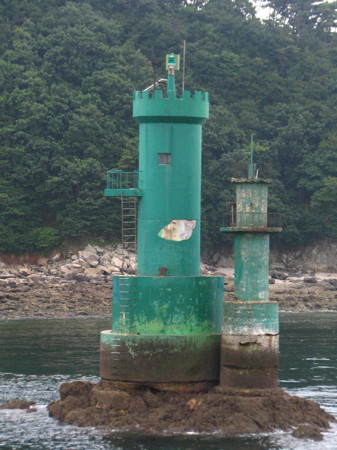
Date unknown. Active; focal plane 12 m (39 ft); three green flashes every 7 s. 16 m (52 ft) round tower, painted green. Google has a street view (a portion is seen at right) and a satellite view. Located on a reef about 2.5 km (1.5 mi) southeast of the Wolamdo light. Accessible only by boat. Site open, tower closed. KR-3496; Admiralty M4163.7; NGA 18063.7.
Muktongdo (Moktongdo)
Date unknown. Active; focal plane 26 m (85 ft); white flash every 6 s. 9.5 m (31 ft) round white concrete tower. No photo available but Google has a distant satellite view. This light guides vessels bound for Incheon around the west end of Jawol. Located on a small island just off the west end of Jawoldo. Accessible only by boat. Site open, tower closed. Admiralty M4169; NGA 18064.
Chochido (Sochochi Do)
Date unknown. Active; focal plane 27 m (89 ft); white flash every 4 s. 8 m (26 ft) square white concrete tower. No photo available but Google has a satellite view. The Chochi Islands are a group of small islands about 5 km (3 mi) northwest of Jawol. The shipping channel leading to Incheon passes through the gap between this light and the Muktongdo Light. Located on Sochochido, the southernmost of the Chochi Islands. Accessible only by boat. Site status unknown. KR-3379; Admiralty M4169.5; NGA 18068.
Chochiam (Chociam)
Date unknown. Active; focal plane 14 m (46 ft); two white flashes every 5 s. 15 m (49 ft) round tower, painted black with a red horizontal band. No photo available but Google has a satellite view. Located on a reef about 7 km (4.5 mi) northwest of Chawoldo. Accessible only by boat. Site open, tower closed. KR-4155; Admiralty M4169.7; NGA 18069.

Hangseo Light, Jawol, July 2018
unattributed Google Maps street view

Yeongheung Township Lighthouses

Budo Area Lighthouses
Budo is a small island at the eastern end of the Ijak group. Lights in this area are guides for ships approaching the Dangjin and Pyeongtaek harbors south of Incheon.
Budo (Bu Do)
1904. Active; focal plane 42 m (138 ft); white flash every 15 s. 12 m (39 ft) round stone tower with lantern and gallery, attached to a keeper's house. 3rd (?) order Fresnel lens in use. Lighthouse painted white. 2-story red brick administration and coast guard building. Fog horn (one blast every 40 s). Sanyu Hwa's photo is at right, a blog has photos from a 2010 visit, Jianzhong Zhang has a view from the sea, and Google has a good satellite view. The original lantern is displayed outside the National Lighthouse Museum in Homigot (see the Pohang Area page). A new and more powerful lens, installed in 2001, increased the range of the light to 50 km (30 mi). Located at the summit of Budo. Accessible only by boat. Site status unknown. KR-4145; Admiralty M4158; NGA 17932.
Nambongyeo (Budo East)
Date unknown. Active; focal plane 15 m (49 ft); six quick white flashes followed by one long white flash every 15 s. 19 m (62 ft) round concrete tower, upper half painted yellow, lower half black. A very distant view (last photo on the page) is available and Google has a distant satellite view. Located on a reef about 1.2 km (3/4 mi) east of Budo. Accessible only by boat. Site open, tower closed. KR-3398; Admiralty M4158.1.
Tongseo (Tongso)
Date unknown. Active; focal plane 12 m (39 ft); green flash every 5 s. 16 m (52 ft) round concrete tower, painted green. No photo available but Google has a satellite view. Located on a rock about 5 km (3 mi) northeast of Budo. Accessible only by boat. Site open, tower closed. KR-3493; Admiralty M4163; NGA 17934.
Mudangseo
Date unknown. Active; focal plane 17 m (56 ft); two white flashes every 5 s. 19 m (62 ft) round cylindrical concrete tower with gallery, painted black with one red horizontal band, mounted on a round concrete pier. No photo available but Bing has a satellite view. Located on a reef in the northern approach to Pyeongtaek. Accessible only by boat. Site open, tower closed. KR-3401; Admiralty M4158.2; NGA 17940.
Budo Light
Budo Light, Yeongheung, June 2013
ex-Daum.net Creative Commons photo by Sanyu Hwa

Yeongheungdo Area Lighthouse
Yeongheungdo is an elliptical island about 10 km (6 mi) in diameter located just off the mainland of Hwaseong, a township south of Incheon. This is the only Ongjin Island accessible from the mainland by bridges.

Baegam (Paek Am)
Date unknown. Active; focal plane 18 m (59 ft); two green flashes every 6 s. 14 m (46 ft) round concrete tower, painted green. No photo available but Bing has a satellite view. Located on a rock off the southwestern tip of Yeongheungdo. Accessible only by boat. Site open, tower closed. Admiralty M4164; NGA 17944.
Namjangja-so
Date unknown. Active; focal plane 18 m (59 ft); red light occulting once every 4 s. 15 m (49 ft) round tower with gallery, painted red, mounted on a platform supported by tripod piles. No photo available but Google has a satellite view. Located on an isolated rock about 5 km (3 mi) north of Yeongheungdo. Accessible only by boat. Site open, tower closed. KR-3549; Admiralty M4164.5; NGA 17956.5.
Bukjangjaseo (Pukjangja-so)
Date unknown. Active; focal plane 18 m (59 ft); two white flashes every 5 s. 14 m (46 ft) round tower with gallery, painted black with one red horizontal band. No photo available but Google has a satellite view. Located on an isolated rock about 8 km (5 mi) north of Yeongheungdo. Accessible only by boat. Site open, tower closed. KR-3548; Admiralty M4166; NGA 17956.
* Jindu Hang
Date unknown. Active; focal plane 19 m (62 ft); green flash every 5 s. Approx. 15 m (49 ft) white concrete tower. Kimmi Somiin has a view from the sea and Google has a satellite view and a distant street view. Located on the outer breakwater of Yeongheungdo's small boat harbor, on the east side of the island. Accessible by walking the pier. Site open, tower closed. Admiralty M4164.27.

Information available on lost lighthouses:

Notable faux lighthouses:

Adjoining pages: North: Incheon Area | South: Dangjin and Pyeongtaek

Return to the Lighthouse Directory index | Ratings key

Posted February 4, 2008. Checked and revised July 8, 2024. Lighthouses: 44. Site copyright 2024 Russ Rowlett and the University of North Carolina at Chapel Hill.