Lighthouses of Egypt: Mediterranean Sea

The Arab Republic of Egypt (Miṣr in Arabic) links northeastern Africa and southwestern Asia with the land bridge of Sinai connecting the two continents. This position has made it an important crossroads of the world for the many millennia of its history. In modern times it became a particularly crucial crossroads in 1869 with the completion of the Suez Canal by a French company, linking Egypt's Mediterranean and Red Sea coasts. At that time Egypt was nominally a province of the Ottoman (Turkish) Empire but in fact it was ruled as a monarchy. British troops invaded and occupied the county in 1882 and it remained a de facto British protectorate until resuming its independence in 1922.

Egypt is famous as the home of the prototype of all lighthouses, the Pharos of Alexandria, built in the early third century BCE. At nearly 120 m (390 ft) it was as tall as a modern skyscraper and much taller than any modern lighthouse. It remained in operation until after the Arab conquest of Egypt in 642 and stood for centuries more, finally collapsing after several earthquakes.

Egypt is divided into 27 governorates and the governorates are subdivided into regions. This page includes lighthouses of the governates on Egypt's Mediterranean Sea coast; there are separate pages for the Sinai Peninsula and Gulf of Suez and for the Red Sea coast.

Arabic is the official language of Egypt. The Arabic word for a lighthouse is mnarh or manara (منارة). Ra's is a cape, jaza'ir or jazirat is an island, shi'b is a reef, shira' is a bay, and marfa is a harbor. Transliteration of Arabic to Latin characters can be done in many ways, so alternate spellings are common.

Coastal aids to navigation in Egypt are operated by the Egyptian Authority for Maritime Safely (EAMS), an agency of the Maritime Transport Sector. A private company, the Beacon Company of Egypt, maintains many of the lights under contract.

ARLHS numbers are from the ARLHS World List of Lights. Admiralty numbers are from volume N of the Admiralty List of Lights & Fog Signals (prior to 2013 the lights were in volume E with the same numbers). U.S. NGA List numbers are from Publication 113.

General Sources
Beacon Company of Egypt - List of Lights
This light list provides data on each light, but no photos. The Red Sea lights are not included.
EAMS - Projects
For lighthouse photos click to "Navigational Aids" and then on "ATON are divided as per their location."
Online List of Lights - Egypt
Photos by various photographers posted by Alexander Trabas. Photos for this coast are by Rainer Arndt or Capt. Peter Mosselberger ("Capt. Peter").
Lighthouses in Egypt
Photos by various photographers available from Wikimedia.
World of Lighthouses - Egypt
Photos by various photographers available from Lightphotos.net.
Afrikanische Leuchttürme auf historischen Postkarten
Historic postcard images posted by Klaus Huelse.
GPSNauticalCharts
Navigational chart for Egypt.
Navionics Charts
Navigational chart for Egypt.


1869 Port Said Light, Port Said, January 2019
Google Maps photo by Mohamed Ahmed

Western Desert Lighthouses

Matruh Governorate Lighthouses
The Matruh Governorate includes the northern portion of Egypt's Western Desert, a thinly populated area that includes a long coastline and a few fishing ports.

* [As Sallum (Saloum) (2)]
Date unknown. Active; focal plane 14 m (46 ft); three white flashes every 20 s. 10 m (33 ft)) steel post, upper half painted black, lower half white. EAMS has a closeup photo, Mohammed Hashem has a very distant view and Google has a satellite view. Located on the pierhead at Sallum, a Bedouin village about 8 km (5 mi) east of the Libyan border. Accessible by walking the pier. Site open, tower closed. Admiralty N6206; NGA 21428.
[Sidi Barrani (Ra's Haleima)]
Date unknown. Active; focal plane 20 m (66 ft); two white flashes every 15 s. 10 m (33 ft) steel post, painted white with a red top, mounted on a concrete base. EAMS has a closeup photo and Google has a distant satellite view. Sidi Barrani was the site of a British victory over Italian troops in December 1940. Located on a headland near Sidi Barrani, about 90 km (55 mi) east of the Libyan border. Site status unknown. Admiralty N6204; NGA 21424.
[Ra's Alam el-Rum]
Date unknown. Active; focal plane 48 m (157 ft); white flash every 5 s. 10 m (33 ft) steel post, painted white with a red band, mounted on a concrete base. EAMS has a closeup photo and Google has a satellite view. Located on heights above a prominent cape about 15 km (9 mi) east of Mersa Matruh. Site open, tower closed. Admiralty N6194; NGA 21420.
* Ra's Shakik (Ra's el Shaqiq, El Hamra)
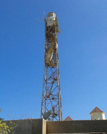
1987. Active; focal plane 47 m (154 ft); three white flashes every 15 s. Approx. 40 m (131 ft) square skeletal tower with lantern, gallery, and a large white rectangular slatted daymark. EAMS has the closeup photo seen at right, Ayman Mohamed has a distant view from a nearby beach, and Google has a satellite view. This lighthouse was built to guide tankers arriving at the El Hamra Oil Terminal, just offshore, where oil from Egypt's Western Desert is shipped. Located on a promontory about 30 km (19 mi) northwest of El Alamein. Site status unknown. ARLHS EGY-044; Admiralty N6193; NGA 21418.

Ra's Shakik Light, Markaz Al Alamein
EAMS photo

Al-Iskandariyya (Alexandria) Governorate Lighthouses

The city of Alexandria (al-ʾIskandariyya in Arabic) is named for Alexander the Great, who founded it in 331 BCE following his conquest of Egypt. Today it is a major port, the third largest city of Egypt, and the largest city of the Mediterranean Sea with a population of more than five million. Most of the harbor lights are maintained by the General Authority for Alexandria Port.

Western Harbors Lighthouses
Sidi Kerir North Breakwater
Date unknown. Active; focal plane about 14 m (46 ft); green light, pattern unknown. Approx. 9 m (30 ft) white tower. No photo available but Google has a distant satellite view. The light guides vessels into the Sidi Kerir Oil Terminal about 30 km (19 mi) southwest of Alexandria. Sidi Kerir is the western terminal of the Sumed Pipeline, which brings oil from Ain Sukhna on the Red Sea, bypassing the Suez Canal. Located on the north (main) breakwater of the harbor. Site and tower closed. Admiralty N6192.4.
Sidi Kerir South Breakwater
Date unknown. Active; focal plane about 14 m (46 ft); red light, pattern unknown. Approx. 9 m (30 ft) red tower. No photo available but Google has a distant satellite view. Located on the south side of the entrance to the harbor. Site and tower closed. Admiralty N6192.5.
Sidi Kerir Range Rear
Date unknown. Active; focal plane about 35 m (115 ft); red light, pattern unknown. Approx. 31 m (100 ft) square skeletal tower. No photo available but Google has an indistinct satellite view. Located behind the beach on the east side of the harbor. Site and tower closed. Admiralty N6192.1.
El Ajami (El Agami)
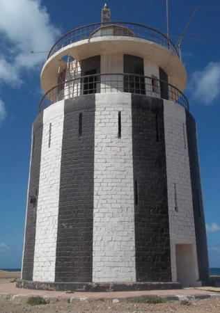
Date unknown. Active; focal plane 17 m (56 ft); two white flashes every 15 s. 14 m (56 ft) stone tower with lantern and gallery, painted with black and white vertical stripes. An EAMS photo is at right, Dimaratos Tchacos has a very distant view and Google has a satellite view. Located on a spit at the westernmost entrance to the Dikheila containership harbor area in El Agami, about 20 km (13 mi) southwest of the center of Alexandria. Site status unknown. ARLHS EGY-012; Admiralty N6173.5; NGA 21412.5.
El Dikheila (El Dikhelia) Breakwater
Date unknown. Active; focal plane 9 m (30 ft); four green flashes, in a 1+3 pattern, every 4 s. Approx. 6 m (20 ft) round tower. No photo available but Google has a satellite view. Located at the end of the breakwater of the Dikheila harbor extending from the end of the El Ajami spit. Site status unknown. Admiralty N6191.2; NGA 21413.7.
El Dikheila (El Dikhelia) Range Front
Date unknown. Active; focal plane 14 m (46 ft); white flash every 3 s. Approx. 13 m (43 ft) round cylindrical metal tower, painted with black and white horizontal bands. No photo available but Google has a satellite view. Located at the end of a pier at the Dikheila harbor. Site status unknown. Admiralty N6191; NGA 21413.
 

El AjamiLight, Alexandria, 2017
EAMS photo
 
El Dikheila (El Dikhelia) Range Rear
Date unknown. Active; focal plane 31 m (102 ft); white light, 1 s on, 1 s off. Approx. 27 m (89 ft) rectangular or triangular concrete tower painted with red and yellow horizontal bands. No photo available but Google has a satellite view. Located on the waterfront of the Dikheila harbor east of El Agami. Site status unknown. Admiralty N6191.1; NGA 21413.5.

Great Pass Lighthouses
Great Pass (Great Pass Beacon)
Date unknown (station established 1899). Active; focal plane 21 m (69 ft); white flash every 4 s. 21 m (69 ft) round cylindrical tower mounted on a round concrete pier. Lighthouse painted with red, green and white horizontal bands. The tower has a lean due to a collision with a ship. Trabas has Capt. Peter's photo and Google has a satellite view. This light marks a junction point on the main Great Pass channel into Alexandria; ships turn southward here to enter the El Dikheila harbor. Located about 1.6 km (1 mi) northeast of the harbor entrance. Accessible only by boat. Site open, tower closed. ARLHS EGY-046; Admiralty N6174; NGA 21370.
* El-Boughaz el-Kebir (Great Pass Range Front) (2)
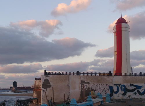
1908 (station established 1894). Active; focal plane 18 m (59 ft); three continuous lights, red near the top of the tower, white in the center, and red near the bottom. 20 m (66 ft) round tapered tower with a domed top rather than a lantern; the lights are shown through small openings. Tower painted with vertical red and white stripes. Wael Mamdoh's photo is at right, Trabas has Capt. Peter's photo, Mahmoud Abdelazez has a 2021 photo, and Google has a satellite view. Capt. Peter calls these lights "the most beautiful leading lights in the world." The range guides ships into the modern harbor of Alexandria, about 13 km (8 mi) southwest of the old city. The lighthouse stands beside the main street along the coast in an industrial area. Site appears open, tower closed. ARLHS EGY-013; Admiralty N6176; NGA 21356.

Great Pass Range Front Light, Alexandria, April 2017
(note 1894 light at lower left)
ex-Google Plus photo by Wael Mamdoh
* Al Maks Upper (Great Pass Range Rear)
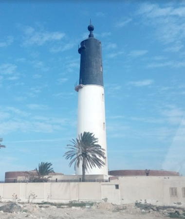
1894. Active; focal plane 38 m (125 ft); two continuous white lights, one above the other; the lower is at a focal plane of 29 m (95 ft). Approx. 30 m (98 ft) round tower with double gallery and a dome topped by a ball-and-spike daymark. Upper half of tower painted black, lower half white. Hisham Abdel Ghani's photo is at right, Trabas has Capt. Peter's photo, and Google has a satellite view. Located 740 m (0.46 mi) southeast of the front light, adjacent to a large petroleum tank farm. Site appears open, tower closed. ARLHS EGY-039; Admiralty N6176.1; NGA 21360.
Al Maks Lower (Great Pass Range Front) (1)
1894. Inactive since 1908. Approx. 11 m (36 ft) hexagonal concrete tower; the former conical dome is in ruins. The lighthouse was formerly painted black but it has lost its paint in recent years. Wikimedia has a nice photo by Ayman F. Khalil, Ahmad Fahmy has a 2022 photo, Mohammed Gad has a photo, Abu Youssef has a 2016 photo, Dosa Dedo has a photo and Google has a satellite view. The beacon was abandoned in 1908 when the line of approach was changed from 134° (southeast) to the present 113° (east southeast). Located on an islet just offshore, about 250 m (275 yd) northeast of the current front range light. Accessible only by boat. Site appears open, tower closed.

West (Inner) Harbor Lighthouses
Alexandria Quarantine Breakwater
Date unknown. Active; focal plane 20 m (66 ft); green flash every 3 s. 19 m (62 ft) square pyramidal skeletal tower, painted green. The top of the tower carries a rectangular slatted daymark painted green with a white vertical stripe. Trabas has Capt. Peter's photo and Bing has an indistinct satellite view. Located at the end of the breakwater on the east side of the entrance to Alexandria's west harbor. Site status unknown. Admiralty N6182; NGA 21384.
Arsenal Quay
Date unknown. Active; focal plane about 13 m (46 ft); green flash every 3 s. Approx. 12 m (39 ft) tapered square pyramidal skeletal tower, painted green with a white band at the top. Trabas has Arndt's photo and Google has an indistinct satellite view. Located at the end of a quay in Alexandria's west harbor. Site status unknown. Admiralty N6190; NGA 21412.
Arsenal Basin West Mole
Date unknown. Active; focal plane 18 m (59 ft); white flash every 3 s. Approx. 16 m (52 ft) square pyramidal skeletal tower with two galleries. The upper half of the tower is enclosed by daymarks colored with red and white horizontal bands. Trabas has Arndt's photo and Bing has an indistinct satellite view. Located at the end of a mole in Alexandria's west harbor. Site status unknown. Admiralty N6189; NGA 21408.

Great Pass Range Rear Light, Alexandria, February 2018
ex-Google Plus photo by Hisham Abdel Ghani
Ra's el-Teen (Ra's at-Tin, Ra's el-Tin)
1848. Active; focal plane 52 m (171 ft); three white flashes, in a 2+1 pattern, every 30 s. 55 m (180 ft) round cylindrical stone tower with lantern and gallery, painted with black and white horizontal bands. Peter and Carolyn Vehslage contributed the photo at right, Trabas has Arndt's closeup photo, EAMS has a closeup, a 2008 photo is available, Wikimedia has Leopold Müller's historic (1878) drawing, and Google has a good satellite view. Located at the western tip of the Ra's el-Tin peninsula marking the entrance to the western harbor of Alexandria. Site probably closed (the lighthouse may be on an Egyptian naval base), tower closed. ARLHS EGY-017; Admiralty N6173; NGA 21344.
Alexandria Outer Breakwater
Date unknown. Active; focal plane 20 m (66 ft); red flash every 3 s. 19 m (62 ft) square pyramidal skeletal tower, painted red. The top of the tower carries a rectangular slatted daymark painted red with a white vertical stripe. Trabas has Capt. Peter's photo, Dmitry Lapin has a view from the sea, and Google has a satellite view. Located at the end of the breakwater on the east side of the entrance to Alexandria's west harbor. Site status unknown. Admiralty N6180; NGA 21380.

Eastern Harbor Lighthouses
* Qaitbay (Qaitbey) Fort (?)
Date unknown. Active; continuous yellow light. This light has long been listed and it is charted by Navionics, but it is not seen in a Wikimedia view of the fort or Oliver Hamoui's closeup photo. Google has a satellite view. The Citadel of Qaitbay is named for the sultan Al-Ashraf Sayf al-Din Qa'it Bay who built it in the 1480s. It is one of Alexandria's best known tourist attractions and for lighthouse fans it is significant as the location of the ancient Pharos of Alexandria. In fact much of the stone in the fort came from the ruins of the Pharos. (The ancient stones are easy to recognize: they are much larger than the others.) Archaeologists working nearby have turned up many artifacts believed to come from the classic lighthouse. Located at the eastern tip of the Ra's el-Tin peninsula, marking the entrance to the eastern harbor of Alexandria. Site open. ARLHS EGY-042; Admiralty N6171.4; NGA 21340.
Ra's el-Tin Light
Ra's el-Teen Light, Alexandria
photo copyright Peter and Carolyn Vehslage; used by permission
Eastern Harbor West Breakwater
Date unknown. Active; focal plane 21 m (69 ft); green flash every 5 s. 10 m (33 ft) green post mounted atop a 1-story octagonal stone tower. Trabas has Arndt's photo, EAMS has a closeup, and Google has a satellite view. Located at the end of the breakwater extending eastward from the Qaitbay fort. Site status unknown. Admiralty N6171; NGA 21332.
Eastern Harbor Detached Breakwater
Date unknown. Active; focal plane 14 m (46 ft); red flash every 5 s. 6 m (20 ft) red post mounted atop a 1-story square stone tower. Trabas has Arndt's fuzzy photo, EAMS has a photo, and Google has a satellite view. Located at the west end of the detached breakwater opposite the west breakwater light. Accessible only by boat. Site status unknown. Admiralty N6170; NGA 21336.

Montazah Lighthouse
* Montazah Palace
Date unknown (1930s). Active (unofficial); focal plane about 23 m (75 ft); continuous (?) white light. Approx. 23 m (75 ft) round stone (?) tower, unpainted, with vertical fluting, lantern, and gallery. A photo is at right, Sherif Aboul Gadayel has a 2013 photo, Naresh Singhal has a 2010 photo, Hossam Elzagh has a 2022 photo, and Google has a satellite view. This frequently-photographed lighthouse is on the "King's Tea Island" in front of the Montazah Palace at the eastern end of Alexandria. The palace was built by Khedive Abbas II around 1900 but the lighthouse was added by King Farouk I, apparently in the late 1930s. It does not appear that this lighthouse was ever an official aid to navigation but Maged Samaan has a 2008 photo showing it in action. Site open, tower closed.

Abu Qir Area Lighthouses
[Jazirat Disuqi (Nelson Island)]
Date unknown. Active; focal plane 22 m (72 ft); white flash every 5 s. 10 m (33 ft) steel post mounted on a concrete base. Upper half of the post painted red, lower half white. EAMS has a photo, Trabas has Capt. Peter's photo, and Google has a satellite view. Named for the famous British admiral, Nelson Island is the site of a cemetery for British soldiers and sailors killed around Alexandria during the Napoleonic wars (1798-1801). Located on a small island off Abu Qir, about 40 km (25 mi) northeast of Alexandria harbor. Accessible only by boat. Site status unknown. Admiralty N6168; NGA 21328.
Abu Qir Range Front (2)
Date unknown. Active; focal plane 20 m (66 ft); continuous red and white lights, one above the other. This was originally a 20 m (66 ft) square skeletal tower originally mounted on a platform supported by piles; the light is now located on a large quay. Trabas has Capt. Peter's photo of the original light and Google has a satellite view of the current one. Located about 100 m (110 yd) offshore on the south side of Abu Qir. Accessible only by boat. Site open, tower closed. Admiralty N6168.3; NGA 21331.

Montazah Palace Light, Alexandria, January 2013
Wikimedia Creative Commons photo by Taha Ahmed
Abu Qir Range Rear
Date unknown. Active; focal plane 23 m (75 ft); continuous red and white lights, one above the other. 23 m (75 ft) square skeletal tower mounted on a platform supported by piles. Trabas has Capt. Peter's photo and Google has a satellite view. Located about 350 m (0.2 mi) south of the front light. Accessible only by boat. Site open, tower closed. Admiralty N6168.31; NGA 21331.1.

Nile Delta Lighthouses

In its modern form the Nile Delta is bounded by the two main branches of the river, the Ra'shid or Rosetta Branch on the west and the Dumyat or Damietta Branch on the east. Dumyat (Damietta), a large commercial seaport at the mouth of the Damietta Branch (Masaab Dumyat), has been improved for navigation by large ships. The Rosetta Branch (Masaab Ra'shid) is navigable only for small craft. The edge of the delta is subject to rapid erosion because modern dams prevent the Nile from bringing down sufficient sediment to combat rising sea levels.

Beheira Governorate Lighthouses
Maadiya (Mu'addīyah) Range Front
Date unknown. Active (privately maintained); focal plane about 19 m (62 ft); two continuous lights, white above red. 15 m (49 ft) square skeletal tower painted orange and carrying a triangular yellow daymark. No photo available but Google has a satellite view. The Maadiya harbor is maintained by Petrojet, an Egyptian oil and gas company. Located on the main breakwater of the harbor about 10 km (6 mi) southeast of Abu Qir. Site and tower closed. Admiralty N6168.5.
Maadiya (Mu'addīyah) Range Rear
Date unknown. Active (privately maintained); focal plane about 30 m (98 ft); two continuous lights, white above red. 24 m (79 ft) square skeletal tower painted orange and carrying a triangular yellow daymark. No photo available but Google has a satellite view. Located within the Petrojet facility 375 m (1/4 mi) south of the front light. Site and tower closed. Admiralty N6168.51.

Kafr el-Sheikh Governorate Lighthouses
* Ra'shid (Ra'schid, Rosetta) (3)
1991 (station established 1870). Active; focal plane 47 m (154 ft); four white flashes every 20 s. Approx. 40 m (131 ft) square skeletal tower with lantern and gallery carrying a rectangular vertically slatted daymark. EAMS has a closeup photo, Amr Rahma has a distant 2019 view and Google has a satellite view. Due to rapid erosion the original lighthouse, a black tripod skeletal tower with lantern and gallery, had to be replaced in 1967; there's a painting of that lighthouse dated 1962. Continued erosion forced another replacement in 1991. The new light station has been relocated well away from danger of erosion: it is in a large fish farm 1.9 km (1.2 mi) from the beach and 9 km (4.5 mi) east southeast of the current Rosetta Mouth of the Nile. Accessible by road. Site probably open, tower closed. ARLHS EGY-037; Admiralty N6166; NGA 21324.
* Borolus (Burullus) (1)
1870. Inactive since 1992. 39 m (128 ft) (?) cast iron tripod skeletal tower, with lantern and gallery. Large 1-story keeper's quarters complex. Hamid Abu-Zeid's photo is at right and Ahmed HanOura has a 2017 closeup and a photo showing both lighthouses; Google has a good satellite view. This lighthouse and its sibling at Ra's Gharib on the Gulf of Suez (see the Egypt Red Sea page) are two of four lighthouses ordered from France by Ismail Pasha in connection with the opening of the Suez Canal. According to EAMS the Damietta lighthouse was "renewed" in 1992 and a new lighthouse was constructed at Borolus. Accessible by road. Site probably open, tower closed. ARLHS EGY-009.
* Borolus (Burullus) (2)
1992 (station established 1870). Active; focal plane 47 m (154 ft); three white flashes every 20 s. 39 m (128 ft) (?) square skeletal tower with lantern and gallery. The lantern is painted white, and the upper 2/5 of the tower carries a rectangular vertically slatted daymark also painted white. EAMS has a photo, Hamid Abu-Zeid's photo is at right, Ahmed HanOura has a photo showing both lighthouses, and Google has a satellite view. Located about 150 m (500 ft) southwest of the historic lighthouse. The light marks the extreme northern end of the Nile Delta at Cape Burullus, about 6 km (4 mi) north of Baltim and on the west side of the town of Burullus. Accessible by road. Site probably open, tower closed. Admiralty N6162; NGA 21320.
Burullus Lights
New and Old Burullus Lights, Burullus, August 2007
ex-Panoramio photo copyright Hamid Abu-Zeid; permission requested

Dumyat (Damietta) Governorate Lighthouses
Damietta (Dumyat) Port Range Front
Date unknown. Active; focal plane 33 m (108 ft); continuous red light. Approx. 30 m (98 ft) round steel tower. The lighthouse is left of center in a 2020 photo and Google has a satellite view. Damietta Port is an artificial harbor created as part of an industrial development on the west side of the Damietta Mouth. Located on the waterfront of the port. Site and tower closed. ARLHS EGY-033; Admiralty N6159; NGA 21317.
Damietta (Dumyat) Port Range Rear
Date unknown. Active; focal plane 41 m (135 ft); continuous red light. Approx. 38 m (125 ft) square skeletal tower. The lighthouse is at the far left in a 2020 photo and Google has a satellite view. Located in the port area 170 m (185 yd) south of the waterfront. Site and tower closed. ARLHS EGY-033; Admiralty N6159.1; NGA 21317.1.
* Damietta (Dumyat) West Breakwater (Ra's el Bar) (2?)
Date unknown. Active; focal plane 14 m (46 ft); green flash every 10 s. 10 m (33 ft) octagonal tower with lantern and gallery. The tower appears to be white concrete; lantern painted green with a metallic gray dome. A photo is at right, EAMS has a closeup photo, Wikimedia has several photos, Ibrahim Albadrawi has a photo showing both breakwater lights, Taher Mohamed has a street view, Yousef Raouf has a second street view and Google has a satellite view. This lighthouse is part of the recent development of Damietta as an important port of entry. Located at the end of the west breakwater at the entrance to the Damietta Branch of the Nile. Accessible by walking the pier. Site open, tower closed. ARLHS EGY-014; Admiralty N6158; NGA 21312.
Damietta East Breakwater (Ezbat el-Burj)
Date unknown. Active; focal plane about 12 m (39 ft); red light, characteristic unknown. Approx. 10 m (33 ft) round concrete tower with gallery, painted red. EAMS has a closeup photo, Fadi Hallisso has a photo, Wikimedia has Heba Otefy's photo of the light in action, Ibrahim Albadrawi has a photo showing both breakwater lights, Yousef Raouf has a street view from the west breakwater and Google has a satellite view. Located at the end of the east breakwater at the entrance to the Damietta Branch of the Nile. Site and tower closed. Oddly, this light is not listed by the Admiralty.
Damietta (Dumyat) (2)
1992 (station established 1870). Active; focal plane 47 m (154 ft); two white flashes every 30 s. 39 m (128 ft) (?) square skeletal tower with lantern and gallery, two sides of the upper portion carrying a white daymark. Keeper's house. EAMS has a closeup, Google has copy of the EAMS photo, Mohamed Masoud Hamady has a 2019 view across the river, Taher Mohamed has a very distant street view from the west breakwater and Google has a satellite view. According to EAMS the Damietta lighthouse was "renewed" in 1992 and a new lighthouse was constructed at Borolus. The original lighthouse seems to have been replaced and demolished at that time. Ahmed Eldeyarby has a historic photo of the older light. Located on the east side of the entrance. Site and tower closed. ARLHS EGY-011; Admiralty N6156; NGA 21308.

West Breakwater Light, Damietta, January 2014
Flickr Creative Commons photo by camilo g.r.

Suez Canal Entrance Lighthouses

Bur Sa'id (Port Said) Governorate Lighthouses
The French founded the city of Port Said (Bor Sa'id in Arabic) in 1859 at the northern terminus of the Suez Canal; they named it for the Egyptian ruler Muhammad Sa'id Pasha, who had granted them the right to build the waterway. Today it is Egypt's fifth largest city with a population of more than 600,000. Lights in this section are maintained by the Suez Canal Authority.
* Port Said (3)
1997. Active; focal plane 47 m (154 ft); three white flashes every 15 s. 39 m (128 ft) square skeletal tower with lantern and gallery. The lantern is painted white, and the upper 2/5 of the tower carries a rectangular slatted daymark also painted white. An EAMS photo is at right, Taha El Hossary has a 2019 photo, Omar Mido has a photo and Google has a satellite view. The lighthouse is a sibling of the 1992 Borolus lighthouse seen above. Located about 2.5 km (1.5 mi) west of the entrance to the canal, across the street from the Port Said Stadium. Site and tower closed but the lighthouse is easily seen from anywhere in the neighborhood. Operator: Suez Canal Authority. Admiralty N5978.2; NGA 21276.
* Port Sa'id (2)
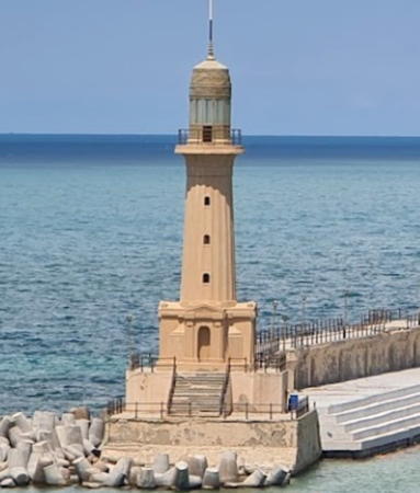
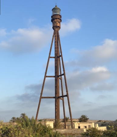
1869 (station established 1860). Inactive since 1997(?). 59 m (194 ft) octagonal reinforced concrete, brick-faced tower with lantern and gallery, attached to 2-story keeper's house. The north (seaward) side of the tower is painted with a black and white checkerboard pattern; the rest of the tower is unpainted yellow brick; lantern painted white. Mohamed Ahmed's 2019 photo is at the top of this page, Sherief Abd Elrahman has a 2021 photo, Michael Tyler has a good 2008 photo, Wikimedia has several photos, Atta Dergham has a photo, Mohammed Saber Al Samman has a closeup from the rear, Huelse has a historic postcard image and Google has a satellite view. This lighthouse is the tallest lighthouse in Africa. Built to mark the northern entrance to the Suez Canal, it was designed by François Coignet based on the Phare des Baleines on the Île de Ré on France's Charente coast. It was one of the first large lighthouses to be built using the relatively new technology of reinforced concrete. The checkerboard daymark pattern was applied in 1926. The first lighthouse was an octagonal wood skeletal tower. Located in downtown Port Said on the west side of the entrance to the canal. Site open, tower status unknown. ARLHS EGY-016; ex-Admiralty N5978.
Port Said Entrance Range Front
Date unknown. Active; focal plane 36 m (118 ft); continuous red light. 40 m (131 ft) square skeletal tower. The top of the tower carries a triangular daymark, point up; there is also a a large rectangular daymark on the upper part of the tower. Trabas has a photo by Douglas Cameron and Google has a satellite view. Located in a crowded dockyard on the west side of the canal, about 2.5 km (1.5 mi) south of the entrance. Site status unknown. Operator: Suez Canal Authority. ARLHS EGY-035; Admiralty N5980; NGA 21284.
* Port Said Entrance Range Rear
Date unknown. Active; focal plane 46 m (151 ft); red light occulting twice every 10 s. 54 m (177 ft) square pyramidal skeletal tower. The top of the tower carries a circular daymark; there is also a a large rectangular daymark on the middle part of the tower. Trabas has a photo by Douglas Cameron and Google has a satellite view. Located on Al Kaboti Street in a warehouse district, 1.1 km (0.7 mi) southwest of the front light. Site open, tower closed. Operator: Suez Canal Authority. ARLHS EGY-036; Admiralty N5980.1; NGA 21288.

1997 Port Said Light, Port Said, 2017
EAMS photo
Port Said East Breakwater
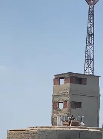
Date unknown. Active; focal plane about 38 m (128 ft); red light occulting once every 6 s. Approx. 28 m (92 ft) square skeletal tower with gallery, lower section enclosed, mounted on a square concrete base. Lighthouse painted red. A concrete harbor control tower (no longer used) is adjacent to the lighthouse. Jürgen Klinksiek has contributed the photo at right, Trabas has a good photo and Google has a satellite view. Located at the end of the east breakwater at the Suez Canal entrance. Site and tower closed. Operator: Suez Canal Authority. Admiralty N5979; NGA 21292.
El Bahar Tower
2008. Active; focal plane 42 m (38 ft); white light, 1 s on, 1 s off. 42 m (138 ft) skeletal tower, painted with red and white horizontal bands. No photo available and the tower is not shown in Google's satellite view. Described by the Suez Canal Authority as a "guidance light," this tower stands between the approach channels to the original Canal (western) entrance and the Bypass (eastern) entrance, about 6 km (3.6 mi) offshore. Accessible only by boat. Site status unknown. Admiralty N5978.6; NGA 21292.5.
Port Said Bypass West
1980s. Active; focal plane 25 m (82 ft); two green flashes every 10 s. 40 m (131 ft) square skeletal tower; the navigation light is shown about 2/3 of the way up the tower. Trabas has Jim Smith's photo and Google has a satellite view. Built in the early 1980s, the Port Said Bypass is an alternate northern entrance to the Suez Canal, located east of the original canal and allowing ships to bypass the crowded dock areas of Port Said. Located on the west side of the bypass opposite the Bypass East light. Site status unknown. Operator: Suez Canal Authority. ARLHS EGY-032; Admiralty N5985.2; NGA 21304.
Port Said Bypass East
1980s. Active; focal plane 25 m (82 ft); two red flashes every 10 s. 23 m (75 ft) square skeletal tower. Trabas has Jim Smith's photo and Google has a good satellite view. This light is on the east side of the bypass about 800 m (1/2mi) south of the entrance, marking a point where the waterway narrows sharply. Operator: Suez Canal Authority. Site status unknown. ARLHS EGY-031; Admiralty N5985; NGA 21300.
East Port Said West Breakwater
Date unknown. Active; focal plane about 23 m (75 ft); continuous white light. Approx. 20 m (66 ft) square pyramidal skeletal tower painted with green and white horizontal bands. Kynady Nady has a distant street view and Google has a satellite view. Located on the west breakwater of the East Port. Site status unknown. Admiralty N5983.2; NGA 21294.

Port Said East Breakwater Light, May 2001
photo copyright Jürgen Klinksiek; used by permission
East Port Said East Breakwater
Date unknown. Active; focal plane about 23 m (75 ft); continuous white light. Approx. 20 m (66 ft) square pyramidal skeletal tower painted with red and white horizontal bands. No photo available but Google has a satellite view. Located on the east breakwater of the East Port. Site status unknown. Admiralty N5983; NGA 21293.

Sinai Peninsula North Coast Lighthouses

North Sinai Governorate Lighthouse
Arish (El Arish) West Breakwater
Date unknown. Active; focal plane about 16 m (52 ft); green light, pattern unknown. Approx. 14 m (46 ft) round barbell-shaped green tower. EAMS has an indistinct photo, the light is near the left edge in a photo by Ragab Hafiez, and Google has a satellite view. Located near the base on the long west breakwater at Arish. Site status unknown. Admiralty N5974.
Arish (El Arish) Range Front
Date unknown. Active; focal plane about 16 m (52 ft); red light, pattern unknown. Approx. 14 m (46 ft) square skeletal tower carrying a large red slatted daymark. EAMS has a closeup photo, the light is near the right edge in a photo by Ragab Hafiez and Google has a satellite view. Located on the waterfront of Arish harbor. Site status unknown. Admiralty N5974.8.
Arish (El Arish) Range Rear
Date unknown. Active; focal plane unknown; red light, pattern unknown. Approx. 12 m (39 ft) square skeletal tower carrying a large red slatted daymark. EAMS has a closeup photo and the light is centered in a Google satellite view. Located about 250 m (820 ft) southwest of the front light. Site status unknown. Admiralty N5974.81.
Arish (El Arish) East Breakwater
Date unknown. Active; focal plane about 16 m (52 ft); red light, pattern unknown. Approx. 14 m (46 ft) round barbell-shaped red tower. EAMS has a photo and Google has a satellite view. Located at the end of the short east breakwater at Arish. Site status unknown. Admiralty N5974.5.
Arish (El Arish)
1997. Active; focal plane 39 m (138 ft); white flash every 5 s. Approx. 35 m (115 ft) round concrete tower with lantern and double gallery, painted with black and white horizontal bands. An EAMS photo is at right, Wajd Attal has a view from the sea and Google has a good satellite view. Located at the foot of the east breakwater on the waterfront of El Arish, a town on the northern shore of the Sinai Peninsula about 50 km (30 mi) west of the Gaza Strip border. Site status unknown. ARLHS EGY-034; Admiralty N5973; NGA 21274.

Information available on lost lighthouses:

  • Lake Menzaleh (1900?-?), Mediterranean coast near Port Said. There is no longer a light at this location. ARLHS EGY-047.

Notable faux lighthouses:


El Arish Light, El Arish, 2017
EAMS photo

Adjoining pages: East: Gaza | Southeast: South Sinai and Suez | South: Egypt Red Sea | West: Libya

Return to the Lighthouse Directory index | Ratings key

Posted July 25, 2006. Checked and revised June 5, 2023. Lighthouses: 48. Site copyright 2023 Russ Rowlett and the University of North Carolina at Chapel Hill.