Lighthouses of Spain: Coast of Morocco

The Kingdom of Spain includes two cities and several additional outposts on the north coast of Morocco. Ceuta is in the north of Morocco directly opposite Gibraltar. The city was occupied by Portugal in 1415 but it has been under Spanish control since Portugal and Spain separated in 1640. Melilla is in the northeastern corner of Morocco near the Algerian border. Melilla has been Spanish since 1497. These two cities were the first -- and are now the last -- European possessions on the African mainland.

Ceuta and Melilla have the status of autonomous cities within Spain. In addition to the two cities Spain administers as federal territories several small islands of the Mediterranean near the coast of Morocco, known collectively as the plazas menores de soberanía (lesser places of sovereignty). All these territories are claimed by Morocco.

The word for a lighthouse is faro in Spanish but its use is generally restricted to the larger coastal light stations. Smaller lighthouses are called balizas (beacons). In Spanish isla is an island, cabo is a cape, punta is a promontory or point of land, péñon is a rock, arrecife is a reef, bahía is a bay, ría is an estuary or inlet, estrecho is a strait, río is a river, and puerto is a port or harbor.

The navigational lights in Spain are the responsibility of the national port authority, Puertos del Estado, but most of them are operated and maintained by regional port authorities. The Comisión de Faros, founded in 1842 to build and maintain Spanish lighthouses, is now an advisory panel.

ARLHS numbers are from the ARLHS World List of Lights. ES numbers are from the Spanish national list of lights, Libro de Faros. Admiralty numbers are from volume E of the Admiralty List of Lights & Fog Signals. U.S. NGA List numbers are from Publication 113.

General Sources
Libro de Faros y Señales de Niebla
Online edition of the official Spanish light list.
Lighthouses in Melilla and Ceuta
Photos by various photographers available from Wikimedia.
World of Lighthouses - Non-continental Spain
Photos by various photographers available from Lightphotos.net.
Online List of Lights - Morocco Mediterranean and Strait of Gibraltar
Photos by various photographers posted by Alexander Trabas.
Afrikanische Leuchttürme auf historischen Postkarten
Historic postcard images posted by Klaus Huelse.
GPSNauticalCharts
Navigational chart information for northern Morocco.
Navionics Charts
Navigational chart for northern Morocco.
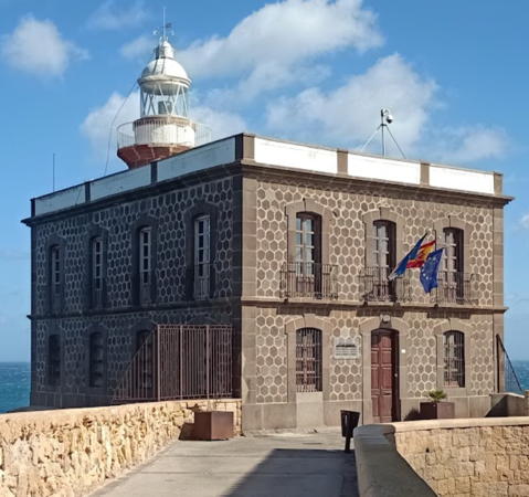


Bonete Light, Melilla, February 2024
Google Maps photo by Rubén González
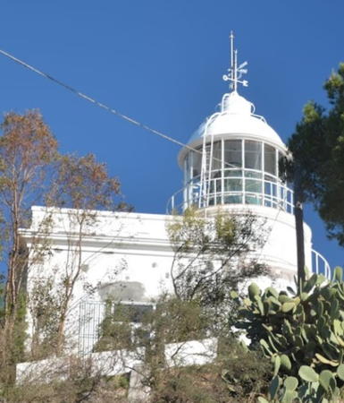
Ceuta City Lighthouse
Ceuta has a population of about 85,000. It has an active port and enjoys duty-free status.
* Punta Almina
1855 (extensively rebuilt 1919). Active; focal plane 148 m (486 ft); two white flashes every 10 s. 16 m (52 ft) round cylindrical masonry tower with lantern and gallery rising from a 1-story keeper's house. 2nd order Henry-Lepaute Fresnel lens (1919). Entire lighthouse painted white. The fog siren (two blasts every 45 s) is located 200 m (220 yd) northeast at the tip of the point. The lantern was installed during a major renovation in 1919; it is not clear if this renovation was a reconstruction or a repair of the original lighthouse.A 2023 photo by C. Antonio González is at right, Peter Goulding has a page with excellent photos, Xavier Rivera has a good photo, Trabas has a distant view by Capt. Peter Mosselberger, Benjamin Marfil Palomino has a closeup, Huelse has a historic postcard view, and Google has a satellite view. Punta Almina is the point of land in Africa directly opposite the Rock of Gibraltar, so this lighthouse marks the south side of the entrance to the Mediterranean Sea from the Strait of Gibraltar. Located at the northeastern point of the Isla de Santa Catarina, although the island has long been connected to the mainland by fill. Ceuta is accessible by ferry from Algeciras on the north side of the Strait of Gibraltar. Site open, tower closed. Operator: Autoridad Portuaria de Ceuta. ARLHS CEU-007; ES-20620; Admiralty D2482; NGA 22840.

Peñón de Vélez de la Gomera
Lighthouse
Peñón de Vélez de la Gomera is a small island (connected to the coast by a sandbar since 1934) about 40 km (25 mi) west of Al Hoceima. Spain has occupied the island continuously since 1564. A small Spanish military garrison is based on the island; there is an aerial photo of the fortress.

Peñón de Vélez de la Gomera
1899. Active; focal plane 47 m (154 ft); three white flashes every 20 s. 6 m (20 ft) gray mast mounted on a short, square tower at one end of a 1-story stone keeper's house. Pedro Garcia has a photo, another photo is available, and Bing has a satellite view.Located on the north side of the island. Accessible only by boat. Site and tower closed (restricted military area). Operator: Autoridad Portuaria de Melilla. ARLHS CEU-010; ES-72660; Admiralty E6788; NGA 22816.

Punta Almina Light, Ceuta, February 2023
Google Maps photo by Carlos Corzo

Melilla City Lighthouses
Primarily a fishing port, Melilla has a population of 86,000.
* Bonete (Melilla) (2)
1918 (station established 1888). Active; focal plane 40 m (131 ft); white light oculting twice every 6 s. 12 m (39 ft) round stone tower with lantern and gallery, rising from the front of a rectangular 2-story stone keeper's house. The lighthouse is unpainted reddish stone; the lantern is silvery metallic. A 2024 photo by Rubén González is at the top of the page, a fine closeup and a second closeup are available, Wikimedia has numerous photos, Huelse has a historic postcard view, Raúl García has a street view, and Google has a satellite view. This lighthouse is part of the historic bastion of Melilla; it is perched on a massive stone foundation rising above the north side of the harbor. Huelse also has a 1909 postcard view of the original lighthouse; it was established by the military by adding a lantern to an existing watch tower. Site closed, but the lighthouse can be viewed from nearby. Operator: Autoridad Portuaria de Melilla. . ARLHS CEU-011; ES-72900; Admiralty E6758; NGA 22736.
Melilla Northeast Breakwater
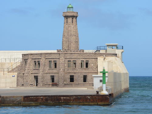
1937. Active; focal plane 33 m (108 ft); green flash every 4 s. 30 m (98 ft) hexagonal cylindrical stone tower with six stone buttresses, lantern and gallery. The lighthouse is unpainted gray stone; lantern is weathered green. A 1-story keeper's quarters encircles the tower. A 2013 photo is at right, Oscar Vivar has a 2019 photo, Enrique Perez Martinez has a 2020 photo, Yeray Díaz Zbida has a view from the sea, and Google has a satellite view. The green post light on the corner of the quay is also active (focal plane 7 m (23 ft); green flash every 4 s). Located at the end of the breakwater at the north end of the harbor of Melilla. Site and tower closed. Operator: Autoridad Portuaria de Melilla. ARLHS CEU-002; ES-72910; Admiralty E6762; NGA 22740. Green pierhead light: ES-72911; Admiralty E6763; NGA 22742.


Northeast Breakwater Light, Melilla, August 2013
Wikimedia Creative Commons photo by Miguel


Islas Chafarinas Lighthouses
The Islas Chafarinas are three islands located about 3 km (2 mi) off Ra's el Ma (Cap de l'Eau) at the eastern end of the Moroccan coast. There are no permanent settlements but since 1847 there has been a Spanish military garrison on Isla Isabel II, the second largest of the islands. In fact, the original light was established by the army on one of its watchtowers; officers were impatient with the bureaucrats who could not decide what kind of lighthouse to build.

Isla del Congreso
Date unknown. Active; focal plane 36 m (118 ft); red flash every 4 s. 3 m (10 ft) round cylindrical white conctete tower. The light is right of center in Dima Rahhal's very distant view and Google has a satellite view. Located on the southern tip of Isla del Congreso, the westernmost of the islands. Accessible only by boat. Site status unknown. ARLHS CEU-006; ES-73120; Admiralty E6752; NGA 22732.
Isla Isabel II (Islas Chafarinas) (2)
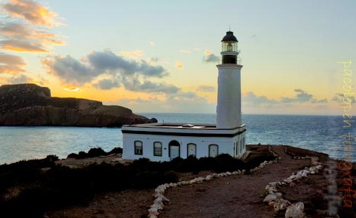
1899 (station established 1884). Active; focal plane 52 m (171 ft); white flash every 7 s. 18 m (59 ft) round masonry tower with lantern and gallery, rising from one side of a 1-story keeper's house. Lighthouse painted white; lantern, gallery, and watch room painted green; house painted green with white trim. A portion of a panoramic photo by Paco Lopez is at right, C.W. Bash has a 2007 photo by Angel Ruiz Migens, Sheila Geary has a 2008 view from the sea, and Google has a satellite view. Located on the northwestern point of the island, about 48 km (30 mi) east of Melilla. Accessible only by boat; there is a distant view from the beach at Ra's el Ma. Site and tower closed (restricted military area). Operator: Autoridad Portuaria de Melilla. ARLHS CEU-001; ES-73100; Admiralty E6754; NGA 22724.

Isla Isabel II Light, Islas Chafarinas, November 2011
Flickr Creative Commons photo by Paco Lopez

Information available on lost lighthouses:

Notable faux lighthouses:

Adjoining pages: North: Eastern Andalusia | Surrounding: Northeastern Morocco | West: Northwestern Morocco

Return to the Lighthouse Directory index | Ratings key

Posted August 10, 2005. Checked and revised June 2, 2024. Lighthouses: 6. Site copyright 2024 Russ Rowlett and the University of North Carolina at Chapel Hill.