Lighthouses of Northeastern Morocco

The Kingdom of Morocco occupies the northwestern corner of Africa across the Strait of Gibralter from Spain. It has a long coast facing northwest on the Atlantic Ocean and a much shorter coast facing north on the easternmost Mediterranean Sea. During most of the nineteenth century France, Spain, and other European countries maneuvered to gain control of Morocco. In 1912 it was finally divided; although the monarchy remained in place France and Spain assumed formal protectorates over the country. The French protectorate included the northwestern coast from the Agadir area through Mehdia, while Spain had a protectorate over the northern coast and portions of the far south. In 1923 the northwestern city of Tangier was removed from the Spanish sector to become an international zone. Morocco resumed its independence in 1956 but Spain continues to control the northern cities of Ceuta and Melilla and several small islands off the Mediterranean coast.

For lighthouse fans the implication of this history is that Morocco's lighthouse heritage is partly Spanish and partly French. The French zone of influence extends from Mehdia to Agadir, with Spanish influence to the north and south. However, the design of lighthouses in all parts of the country shows a strong native Moroccan style.

This page includes lighthouses of Morocco's northeast coast facing the Mediterranean Sea; it includes lighthouse from two of the country's twelve administrative regions. There are separate pages for Southwestern Morocco, Northwestern Morocco and the Spanish Coast of Morocco (including Ceuta and Melilla).

Arabic and Berber are the official languages in Morocco. Darija (a Berber-influenced dialect of Arabic) and French are common spoken languages. The Arabic word for a lighthouse is mnarh or manara (منارة). Ra's is a cape or headland.

Lighthouses in Morocco are operated by the Etablissements de Signalisation Maritime (ESM) division of the infrastructure ministry (Ministère de l'Équipement et de l'Eau).

ARLHS numbers are from the ARLHS World List of Lights. Admiralty numbers are from volumes D and E of the Admiralty List of Lights & Fog Signals. U.S. NGA List numbers are from Publication 113.

General Sources
Online List of Lights - Morocco Mediterranean
Photos by various photographers posted by Alexander Trabas.
Lighthouses in Morocco
Photos by various photographers available from Wikimedia.
World of Lighthouses - Morocco
Photos by various photographers available from Lightphotos.net.
Phares d'Afrique
Photos by various photographers posted by Alain Guyomard and Robert Carceller.
Afrikanische Leuchttürme auf historischen Postkarten
Historic postcard images posted by Klaus Huelse.
GPSNauticalCharts
Navigational chart information for northern Morocco.
Navionics Charts
Navigation chart for Morocco.


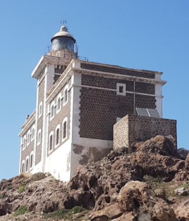
Cap des Trois Fourches Light, June 2022
Google Maps photo by Khalid Yek
Tanger-Tetouan-Al Hoceima Region: Lighthouses East of Ceuta
For lighthouses of this region west of the Spanish city of Ceuta see the Northwestern Morocco page.

*
Marina Smir
Date unknown. Active (privately maintained?); focal plane 11 m (36 ft); green light, 2 s on, 2 s off. Approx. 7 m (23 ft) round strongly conical stone tower; the upper 3/4 of the tower is painted green. Adnan Al Deibani has a distant view across the harbor, Morad Sital has a distant street view from the beach, and Google has an indistinct satellite view. Located at the end of the breakwater at Marina Smir, a resort harbor about 16 km (10 mi) south of Ceuta. Accessible by walking the pier. Site open, tower closed. Admiralty E6830; NGA 22838.
* Ra's El Aswad (Ra's Tarf, Cabo Negro)
Date unknown. Active; focal plane 135 m (443 ft); white light occulting once every 4 s. 13 m (43 ft) octagonal cylindrical tower with gallery and a small lantern. Upper 2/3 of the tower is gray, lower 1/3 white. Younes Rahali has a fuzzy street view and Google has a satellite view. This lighthouse is in an area developed intensively for tourism. The lighthouse is listed as an attraction and is known for commanding a spectacular view of the Mediterranean Sea and the Rif Mountains, but photos are very difficult to find. Located on a cape near Mdiq, about 8 km (5 mi) north of Martíl. Site open, tower closed. ARLHS MOR-017; Admiralty E6824; NGA 22832.
Oued Laou (Ra's Menkal)
1986. Active; focal plane 150 m (492 ft); white light occulting twice every 6 s. Described by NGA only as a "white round tower." No closeup photo available but Google has an indistinct satellite view. The lighthouse is barely visible in a view from the beach bySteve Sanderson and in a similar view from the beach by Hicham El Mejdoubi. Located atop a sharp promontory about 4 km (2.5 mi) north of Oued Laou. Site status unknown. ARLHS MOR-026; Admiralty E6789.5; NGA 22822.
El Jebha (Jabha, Pointe des Pêcheurs) (1 and 2)
Date unknown. Active; focal plane 38 m (125 ft); two white flashes every 10 s. 4 m (13 ft) round tower painted black with a white horizontal band. This light replaced a light mounted on or in a 1-story square equipment room. Both lights are seen, side by side, in Mohamed Nana's 2024 photo and a 2022 photo; only the earlier light is seen in Ismail Moukafih's 2016 photo. Google has an indistinct satellite view. Located on the slope of a steep bluff at El Jebha, about 100 km (60 mi) west of Al Hoceïma and a similar distance southeast of Martíl. Site status unknown. ARLHS MOR-023; Admiralty E6789; NGA 22820.
* Sidi Abed (Ra's el Jadid, Sidi Abid, Morro Nuevo, Punta de los Frailes) (2?)
Date unknown. Active; focal plane 151 m (495 ft); two white flashes every 10 s. 16 m (52 ft) square tower with lantern and gallery. Lighthouse is white; lantern painted black. Miguel Ruiz has the photo at right and Google has a satellite view. 200 m (1/8 mi) southwest is a tall control tower with communications gear and a radar antenna. Located on a cape at the western entrance to the Bay of Al Hoceïma. Accessible by road. Site open, tower closed. ARLHS MOR-008; Admiralty E6786; NGA 22788.
#Al Hoceïma (Alhucemas) East Breakwater (1)
Date unknown. Removed around 2018. 7 m (23 ft) round strongly conical white concrete tower on a square base. Mohammed al Arabi has a distant 2017 view and Enzo Pantosti has a 2004 aerial view, but no tower is seen in Google's satellite view of the breakwater. Located at the original end of the east breakwater at Al Hoceïma. The breakwater has been extended and the light has been moved to a 7 m (23 ft) post at the end of the extension (focal plane 12 m (39 ft); green light, 2 s on, 2 s off). Probably accessible by walking the breakwater. Site open, tower closed. Active light: Admiralty E6785.2; NGA 22808.
Sidi Abed Light
Sidi Abed Light, Al Hoceïma, October 2011
ex-Panoramio photo copyright Miguel Ruiz; used by permission
Al Hoceïma (Alhucemas) Range Front
Date unknown. Active; focal plane 27 m (89 ft); continuous green light. 5 m (16 ft) square tower carrying a diamond-shaped daymark. The range lights are seen on the hillside above the port in Dima Rahhal's photo; this is the lower light, on the right. The tiny light is centered in a Google satellite view. Site status unknown. Admiralty E6784.6; NGA 22800.
Al Hoceïma (Alhucemas) Range Rear
Date unknown. Active; focal plane 46 m (151 ft); continuous green light. 7 m (23 ft) square tower carrying a diamond-shaped daymark. The range lights are seen on the hillside above the port in Dima Rahhal's photo; this is the upper light, on the left. The tiny light is centered in a Google satellite view. Site status unknown. Admiralty E6784.61; NGA 22804.

Oriental Region: Lighthouses West of Melilla
* Cap Quilates (Ra's Tarf, Punta Barbazun)
1930. Active; focal plane 62 m (203 ft); three white flashes every 12 s. 32 m (105 ft) octagonal 3-stage concrete tower with castellated gallery and a small lantern, attached to the seaward side of a 2-story concrete keeper's house. The building is unpainted gray concrete. Abdelmounaim Ahabi's 2023 photo is at right, a page for the lighthouse is available, Elarbi Amakri has a 2017 closeup photo, Soufiane El Kadaoui has a photo, Daniel Brieba has another photo, and Google has a satellite view. Located on the cape about 40 km (25 mi) east of Al Hoceïma. Site open, tower closed. ARLHS MOR-004; Admiralty E6784; NGA 22784.
* Anse Tramontana (Ra's Barakat, Cala Tramontana)
Date unknown. Active; focal plane 49 m (161 ft); white light occulting three times, in a 2+1 pattern, every 12 s. 4 m (13 ft) round cylindrical concrete tower with a small lantern. Lighthouse is unpainted; lantern is green. Houssain Tork has a 2020 closeup photo and Google has a satellite view. Located on a bluff on the west side of the Trois Fourches peninsula about 15 km (9 mi) northwest of Melilla. Site open, tower closed. ARLHS MOR-013; Admiralty E6780; NGA 22776.
Cap des Trois Fourches (Ra's Tleta Madari, Cabo Tres Forcas)
1909. Active; focal plane 112 m (367 ft); four white flashes, in a 3+1 pattern, every 20 s. 18 m (59 ft) square cylindrical stone tower with lantern and gallery, rising from a 2-story stone keeper's house. A 1st order Fresnel lens is mounted in the lantern, although the light may have been moved to a post at the seaward end of the building. The house is dark stone with white trim; lantern painted red with a green dome. Khalid Yek's 2022 photo is at the top of this page, Hamid Kaouass has a closeup photo, Wikimedia has several good photos, Abdelbari Talbi has a street view, and Google has a satellite view. In all languages this is the Cape of Three Forks. It lies at the end of a rocky peninsula projecting about 30 km (19 mi) into the Mediterranean, making this one of the most critically important lights on the Moroccan coast. Located on the cape, about 20 km (13 mi) north of Melilla. Accessible by road, although 4WD may be needed. Site open, tower closed. ARLHS MOR-002; Admiralty E6778; NGA 22772.

Cap Quilates Light, Al Hoceïma, October 2023
Google Maps photo by Abdelmounaim Ahabi
Los Farallónes
1928. Active; focal plane 21 m (69 ft); white light occulting once every 4 s. 5 m (16 ft) round cylindrical masonry tower; lantern removed. Lighthouse painted with gray and white horizontal bands. Tomas Paz has a photo, Juan Pascual has a view from the sea, and Google has a satellite view. Located atop a small rocky island off the east side of Ra's Tleda Madari (Cap des Trois Fourches), about 15 km (9 mi) north of Melilla. Accessible only by boat. Site and tower closed. ARLHS MOR-025; Admiralty E6776; NGA 22768.

Oriental Region: Lighthouses East of Melilla
Ra's el Ma (Ra's Kebdana, Cap de l'Eau) (2)
1946. Active; focal plane 42 m (138 ft); two white flashes every 6 s. 8 m (26 ft) light tower centered on an octagonal stone keeper's house. Next to the historic lighthouse is a square cylindrical concrete tower about 25 m (82 ft) tall carrying a large round control room. The top of the taller tower has communications gear and a radar antennas. A 2021 street view is seen at right, a distant view are available, Lahouari Boulayoun has a distant street view and Google has a good satellite view. Located on the cape near Ra's Kebdana, just northwest of the harbor. Site status unknown. ARLHS MOR-018; Admiralty E6757; NGA 22720.
* Ra's Kebdana Directional
Date unknown. Active; focal plane about 16 m (52 ft); white, red or green light depending on direction, pattern unknown. Approx. 15 m (49 ft) square cylindrical tower rising from a 2-story building. Entire building is white. A 2021 distant view is available, Lahouari Boulayoun has a street view along the pier, and Google has a satellite view. Located on the north breakwater at Ra's Kebdana. Site open, tower closed. Admiralty E6757.1.

Ra's el Ma Light (right), Ra's Kebdana, July 2021
Google Maps street view by ahmed
* Ra's Kebdana North Breakwater
Date unknown. Active; focal plane 12 m (39 ft); green light, 3 s on, 3 s off. 7 m (23 ft) square cylindrical concrete tower, painted white. Nasraddine Touhami has a 2021 photo, this light is on the left in a Lightphotos.net photo of the two lights, Lahouari Boulayoun has a street view along the pier, and Google has a satellite view. Ra's Kebdana is a modern fishing port at the tip of the Ra's el Ma peninsula. Located at the end of the north breakwater. Accessible by walking the pier. Site open, tower closed. ARLHS MOR-035; Admiralty E6757.2; NGA 22721.
* Ra's Kebdana East Breakwater
Date unknown. Active; focal plane 13 m (43 ft); red light, 3 s on, 3 s off. 7 m (23 ft) square cylindrical concrete tower, painted white. Houssain Tork's photo is at right, this light is on the right in a Lightphotos.net photo of the two lights, Lahouari Boulayoun has a street view across the harbor, and Google has a satellite view. Located at the end of the east breakwater. Accessible by walking the pier. Site open, tower closed. ARLHS MOR-034; Admiralty E6757.25; NGA 22722.

Information available on lost lighthouses:

Notable faux lighthouses:


East Breakwater Light, Ra's Kebdana, April 2017
Google Maps photo by Houssain Tork

Adjoining pages: Enclaves: Spanish Morocco | East: Western Algeria | West: Northwestern Morocco

Return to the Lighthouse Directory index | Ratings key

Posted August 18, 2005. Checked and revised June 2, 2024. Lighthouses: 16. Site copyright 2024 Russ Rowlett and the University of North Carolina at Chapel Hill.