Lighthouses of Tanzania

Located on the east coast of Africa, the United Republic of Tanzania was formed by a merger of two dissimilar British colonies, Tanganyika and Zanzibar. Tanganyika included all the mainland of the present country and also Mafia Island. It was the major part of a German colony (German East Africa) until it was captured by British troops in World War I. Britain governed it under a League of Nations mandate until World War II and then under a United Nations trustreeship until it became independent in 1961. Zanzibar, which includes the islands of Unguja (Zanzibar) and Pemba, has a long history as an Arab outpost on the African coast. It was also the site of a Portuguese trading post throughout most of the 16th and 17th centuries, until the Sultan of Oman drove the Portuguese out in 1698. Zanzibar was placed under a British protectorate beginning in 1890 but it continued to be governed autonomously as a sultanate until the British ended their protectorate in 1963. After a revolution overthrew the sultanate Zanzibar joined Tanganyika to form Tanzania in 1964.

Mainland Tanzania is divided into 26 regions (mkoa). Zanzibar, an autonomous region with its own government and legislature, is divided into five regions, three on Unjuga and two on Pemba.

In Swahili, the common language of the Tanzanian coast, the word for a lighthouse is mnara wa taa (related to the Arabic manara). The Arabic word ras is used for a cape.

Lighthouses in Tanzania, except for Zanzibar, are operated by the Tanzania Ports Authority. Lighthouses in Zanzibar are operated by the Zanzibar Ports Corporation.

ARLHS numbers are from the ARLHS World List of Lights. Light List numbers are from volume D of the Admiralty List of Lights & Fog Signals. U.S. NGA List numbers are from Publication 112.

General Sources
Lighthouses of Tanzania in Danger
This July 2008 article in Lighthouse Digest carried alarming reports and photos showing the lighthouses of the Tanga area abandoned and stripped by vandals.
Online List of Lights - Tanzania
Photos by various photographers posted by Alexander Trabas.
Lighthouses in Tanzania
Photos by various photographers available from Wikimedia.
World of Lighthouses - Tanzania
Photos by various photographers available from Lightphotos.net.
Afrikanische Leuchttürme auf historischen Postkarten
Historic postcard views posted by Klaus Huelse.
Navionics Charts
Navigational chart for Tanzania.


Ras Kigomasha Light, Pemba Island, September 2022
Instagram photo by Alexander Georgiev

Zanzibar Lighthouses

Pemba Island Lighthouses
Pemba is a large island about 50 km (30 mi) off the mainland and 50 km (30 mi) north of Unguja (Zanzibar) island. Pemba has a population of about 400,000 and is governed as part of the semi-autonomous region of Zanzibar. As a tourist destination it is not so well known as Zanzibar, but it is popular with scuba divers and ecotourists.

North Pemba Region Lighthouse
*** Ras Kigomasha
1904. Active; focal plane 38 m (125 ft); flash every 55 s (!), alternately red and white. 27 m (89 ft) hexagonal cast iron skeletal tower with lantern, gallery, and central cylinder. Entire lighthouse painted white. Two 1-story keeper's houses. Alexander Georgiev's 2022 photo is at at the top of this page, Jan W. Badura has a 2020 photo, Aleksandar Mandzhukov has a 2016 photo, Erik Willis Garstka has a drone view, and Google has a good satellite view. The lighthouse was prefabricated in England by Chance Brothers. Located on the northwestern tip of Pemba. Accessible by road (4WD recommended). Site open; the keeper will allow visitors to climb the tower, for a fee. . ARLHS ZAN-008; Admiralty D6746; NGA 31276.

South Pemba Region Lighthouses
Matumbi Makubwa (Matumbe Makupa)
Date unknown. Active; focal plane 33 m (108 ft); three white flashes every 20 s. 31 m (101 ft) square stone tower painted with red and white horizontal bands. A 2021 photo is at right and Google has a good satellite view. This lighthouse was restored in 2002-03 by Salem Construction Ltd. Located on a small island off the southwestern tip of Pemba. Accessible only by boat. Site presumably open, tower status unknown. ARLHS ZAN-005; Admiralty D6751; NGA 31280.
[Mkoani Range Front]
Date unknown. Active; focal plane 4 m (13 ft); quick-flashing red light. 6 m (20 ft) skeletal tower atop a square concrete base, carrying a daymark with red and white horizontal bands. The light is in the center of Kassongo Silver's photo and Google has a satellite view. A town of about 25,000 residents, Mkoani is the regional capital and the terminal for ferries arriving from the mainland. Located at the edge of the water on the south side of the pier at Mkoani. Site status unknown. Admiralty D6748; NGA 31284.

Matumbi Makubwa Light, Pemba, January 2021
Google Maps photo by Brownboytravels dot blog

Unguja Island Lighthouses
The island of Unguja (Zanzibar) is 85 km (53 mi) long and up to 30 km (19 mi) wide. It is densely populated, with a population of about 900,000. The capital is the historic city of Stone Town (Mji Mkongwe) on the west coast of the island. Note: the smaller lights of Zanzibar are poorly known and photos of them are needed.

South Unguja Region Lighthouse
* Ras Makunduchi
Date unknown. Active; focal plane 44 m (144 ft); two white flashes every 15 s. 27 m (89 ft) tower, painted with red and white horizontal bands. Lighthouse Digest has Tim McCann's photo, Marco Prete has a 2009 photo, Tim Hennig has a 2021 closeup, a 2022 closeup is available, Trabas has Rainer Arndt's photo, a distant view is available, and Google has a satellite view. A marine science team from Newcastle University in England visited the lighthouse in August 2012 and found it staffed and operating but in need of paint. Their account has several photos. Located on the southeastern point of the island, near the village of Makunduchi. Site open, tower closed. . ARLHS ZAN-009; Admiralty D6700; NGA 31428.

West Unguja Region Lighthouses
Pungume Island
1919. Active; focal plane 26 m (85 ft); white flash every 3 s. 22 m (72 ft) square tower, originally painted with black and white vertical stripes but now with black and white horizontal bands. No photo available but Google has a good satellite view. Pungume is a small island off the southwestern coast of Zanzibar. Located at the southern tip of the island. Accessible only by boat. ARLHS ZAN-007; Admiralty D6702; NGA 31424.
**** Chumbe
1904. Active; focal plane 37 m (121 ft); white flash every 11 s. 34 m (112 ft) square 5-stage unpainted stone tower with lantern and gallery, painted white. Original 4th order Fresnel lens in use, lit by an AGA acetylene system installed in 1926. Keeper's house and a small mosque, built for the keepers, nearby. The keeper's house includes a restaurant and a small museum. Seven modern cottages provide overnight accommodations. A photo is at right, Jeremy Newhouse has a photo, Penny Wilby has a good photo, a 2010 photo and a 2022 closeup are available, and Google has a satellite view. The lighthouse, deteriorated after years of automated operation, was partially restored by Chumbe Island Coral Park, Ltd., which also operates the restaurant and cottages and offers day tours of the island and lighthouse. Lighthouse Digest has Jeremy D'Entremont's feature article on the lighthouse in connection with its 100th anniversary, celebrated in August 2004. This is easily Tanzania's best known lighthouse. Located on a small island 13 km (8 mi) southwest of Stonetown, Zanzibar's main harbor. Accessible by passenger ferry. Site open, tower open to guided tours. Site manager: Chumbe Island Coral Park. . ARLHS ZAN-001; Admiralty D6704; NGA 31416.
Zanzibar Range Front
Date unknown. Active; focal plane 9 m (30 ft); quick-flashing white light. 14 m (43 ft) square pyramidal skeletal tower mounted on piles. Omar Shehe Omar has a photo and Google has an indistinct satellite view. This range leads vessels through the Southern Pass, a break in the reefs southwest of Stonetown. Located about 500 m (0.3 mi) offshore. Accessible only by boat. Site open, tower closed. ARLHS ZAN-002; Admiralty D6706; NGA 31404.
Chumbe Light
Chumbe Light, Zanzibar, December 2010
Flickr Creative Commons photo by sheyneg
* Zanzibar Range Rear
Date unknown. Active; focal plane 40 m (131 ft); white flash every 6 s. 13 m (43 ft) square cylindrical stone tower, painted white. Omar Shehe Omar has a 2022 photo, Federico Debetto has a street view, and Google has a satellite view. This light seems overwhelmed by surrounding trees and buildings. Located on the west side of Nyerere Road south of Stone Town. Site open, tower status unknown. Admiralty D6706.1; NGA 31408.
* #Shangani (Beit-el-Ajaib, "House of Wonders") Clock Tower (2)
1924 (station established 1890s). Partially collapsed in 2020; listed with focal plane 44 m (144 ft); continuous white light. Light mounted on a mast atop a square clock tower on the front of a large palace. Entire building painted white. Trabas has Jim Smith's photo seen at right, Munisch Bhagwanani has a 2007 closeup, Jay Green has a good photo, Nasir Fazal has posted many photos, and Google has a 2019 street view, a satellite view, and a distant 2019 sea view. The Beit-el-Ajaib, or House of Wonders, was built by the Sultan Sayyid Barghash around 1883 as a ceremonial palace. A square clock tower and lighthouse was built in front of the palace, as seen in the postcard view posted by Huelse. In 1896 the buildings were badly damaged when British warships briefly shelled the town during a dispute over the royal succession, a conflict known in Zanzibar as the Shortest War in History (38 minutes). When the building was rebuilt in 1899-1900 the clock tower was incorporated into the center of the front of the building, creating one of Zanzibar's best known landmarks. The building has been used as a royal residence, for government offices, and as a museum. In 2020 the clock tower and some of the rest of the building collapsed during renovation work, as seen in Google's January 2021 street view. There are plans to rebuild the structure. Located on the waterfront of Stone Town. Site open, building open, but tower closed. Site manager: Zanzibar Department of Archives, Museums, and Antiquities. . ARLHS ZAN-010; Admiralty D6718; NGA 31384.
Maruhubi (Marubi) Palace Gardens Range Front
Date unknown. Active; focal plane 10 m (33 ft); quick-flashing white light. 6 m (20 ft) light atop a square stone pyramid. Entire lighthouse is white. No photo available but Google has a satellite view. This range guides vessels on a clear passage along the northwest coast of the island. Located on the beach on the north side of Stone Town, about 250 m (275 yd) south of the Tourism College. Site status unknown. Admiralty D6726; NGA 31376.
Maruhubi (Marubi) Palace Gardens Range Rear
Date unknown. Active; focal plane 28 m (92 ft); white light, 3 s on, 3 s off. 13 m (42 ft) skeletal tower mounted on a square stone tower. Entire lighthouse is white. No closeup photo available but Google has a distant street view and Bing has an indisinct satellite view. The Maruhubi Palace was built in the late 1800s and burned in 1899, leaving picturesque ruins. Located in the palace gardens on the north side of Stone Town, 384 m (1/4 mi) south southeast of the front light. Site status unknown. ARLHS ZAN-004; Admiralty D6726.1; NGA 31380.

Shangani (House of Wonders) Light, Zanzibar
photo copyright Jim Smith; used by permission
Beit-el-Ras Range Rear
Date unknown. Active; focal plane 12.5 m (41 ft); red light occulting once every 6 s. 13 m (43 ft) stone tower painted with black and white horizontal bands. No closeup photo available but Google has a satellite view and a distant street view. This range guides vessels northbound along the coast as they approach Stonetown. The front light is a small beacon on the beach near the Abla Beach Hotel (photo needed!). Located 230 m (250 yd) northeast of the front light, in a built-up area across Malawi Road. Site status unknown. Admiralty D6732.1; NGA 31372.

North Unguja Region Lighthouses
Mangapwani (2)
1926 (station established 1886). Active; focal plane 35 m (115 ft); white flash every 15 s. 23 m (75 ft) square stone tower with lantern and gallery, painted with black and white horizontal bands. The Zanzibar Ports Corporation has posted on Facebook a video showing the lighthouse and its interior. Google has a satellite view. The light marks the start of the coastal passage guided by the Marubi Palace Range Lights. Located on the northwest coast of the island about 25 km (15 mi) north of Stone Town. Site status unknown. ARLHS ZAN-003; Admiralty D6738; NGA 31356.
Tumbatu (Mwana Wa Mwana) Island
1889. Active; focal plane 26 m (85 ft); white flash every 10 s. 23 m (75 ft) six-stage square stone tower with lantern and gallery. The lighthouse appears to be unpainted white stone. Peppe Nesta has a photo, Marco Marini has a 2022 view from the sea, Christo Deysel has a 2023 photo, and Google has a satellite view. This not-so-well known tower is very similar to the famous Chumbe Light, but it is 15 years older. Tumbatu is a long, narrow island off the northwest coast of Zanzibar; it has several resorts, and transportation can be arranged from Stone Town or Nikokotoni. Located on an islet just off the northern tip of the island. Site probably open, tower closed. ARLHS ZAN-006; Admiralty D6740; NGA 31344.
* Ras Nungwi (Hog Point) (2)
1926 (station established 1881). Active; focal plane 18 m (60 ft); white flash every 5 s. 14 m (46 ft) 3-stage square tower with lantern and gallery, rising through the center of a 1-story keeper's house. Building painted white, lantern red. Kris Fricke's photo is at right, Trabas has Eckhard Meyer's photo, Kevin Harber has a closeup of the tower, Henry and Tersia Claasen have a December 2008 photo, Wikimedia has Jarod Burns's photo, and Google has a satellite view. Zanzibar's oldest light station may be endangered: beach erosion has created a steep scarp in front of the building, seen in Burns's photo. Located at the northern tip of Zanzibar. Site open, tower closed. . ARLHS ZAN-011; Admiralty D6742; NGA 31340.


Ras Nungwi Light, Zanzibar, November 2014
Flickr Creative Commons photo by Kris Fricke

Mainland Lighthouses

Tanga Region Lighthouses
Tanga is a seaport near the Kenyan border; it has a population of about 300,000. It was an important base for the German East Africa colony and was not conquered by British troops
until 1916.

Ulenge Island Range Rear (Tanga Bay) (2)
Date unknown (station established 1894). Reactivated (?); focal plane 26 m (85 ft); white light, 4.5 s on, 7.5 s off. 26 m (85 ft) square stone tower with lantern and gallery, painted with black and white horizontal bands. Sybille Riedmueller supplied a photo to Lighthouse Digest, Rachel Dove has a 2007 photo, and Google has a satellite view. This was the only Tanga light until the range was established in 1929. In 2008 Ms. Riedmueller reported that the Fresnel lens was smashed by vandals and the lantern subsequently removed. The tower itself was in dilipidated condition. However it looks better and appears to have a lantern in the current satellite view; also Navionics charts it as active. We need recent photos! This is an approach range guiding ships through the reef off Taanga. Wikimedia has a historic photo of the original lighthouse taken around 1910, and Huelse has a historic postcard view. Located on Ulenge Island, a small island on the north side of the entrance to Tanga Bay. Site status unknown. ARLHS TAN-013; Admiralty D6754.1; NGA 31300.
Ulenge Island Range Front (2)
Date unknown (station established 1929). Reactivated (?); focal plane 12 m (39 ft); quick-flashing white light. 15 m (49 ft) white concrete tower. No photo available but Google has a satellite view. Located 320 m (0.2 mi) southeast of the rear light. Site status unknown. ARLHS TAN-012; Admiralty D6754; NGA 31296.
Toten Island Range Front
Date unknown. Active; focal plane 11 m (36 ft); white flash every 2 s. 9 m (30 ft) white concrete tower. No closeup photo available but Google has a satellite view. Both range lights can be seen very distantly in Marshed Mohamed's view from the waterfront. This is the entrance range for Tanga harbor. Located at the eastern tip of Toten Island, an island off the Tanga waterfront. Accessible only by boat. Site status unknown. Admiralty D6759.55; NGA 31316.
Toten Island Range Rear
Date unknown. Active; focal plane 12 m (36 ft); white flash every 7 s. 9 m (30 ft) white concrete tower. No closeup photo available but Google has a satellite view. Located 75 m (250 ft) west southwest of the front light on Toten Island. Accessible only by boat. Site status unknown. Admiralty D6759.56; NGA 31316.1.
Tanga Inner Range Front
Date unknown. Active; focal plane 6 m (20 ft); white light, pattern unknown. 6 m (20 ft) white concrete tower. Romex Papehe has a view from the harbor showing both range lights, Henry Robert has a very distant 2022 view, and Google has a satellite view. Located just offshore east of the waterfront area of Tanga. Accessible only by boat. Site open, tower closed. Admiralty D6761.
Tanga Inner Range Rear
Date unknown. Active; focal plane about 10 m (33 ft); white light, pattern unknown. Approx. 10 m (33 ft) white concrete tower. Romex Papehe has a view from the harbor showing both range lights but trees appear to have hidden the light in Google's current satellite view. Located just offshore east of the waterfront area of Tanga. Accessible only by boat. Site open, tower closed. Admiralty D6761.1.
Ras Kasone (Kazone) Range Front
Date unknown. Active; focal plane 8.5 m (28 ft); white flash every 1.5 s. 12 m (39 ft) round white concrete tower. William Arnold has a 2019 photo and Google has a satellite view. This is the second range for ships entering Tanga. Located on a sandbar off Ras Kasone, the cape at the entrance to Tanga harbor, about 560 m (0.35 mi) northeast of the rear lighthouse (next entry). Accessible only by boat. Site open, tower closed. Admiralty D6757; NGA 31332.
* Ras Kasone (Kazone) Range Rear
Date unknown. Active; focal plane 29 m (95 ft); white flash every 10 s. 22 m (72 ft) round cylindrical concrete tower topped by a circular harbor control room, gallery, and signal mast. The light is probably displayed from the gallery. The lighthouse is white concrete with a narrow black vertical stripe. Hans Martin's photo is at right, Anthony Proches has a distant 2017 view, and Google has a satellite view. The control room has been abandoned and stripped of all its equipment. Located on Ras Kasone, the cape at the entrance to the harbor. Site status unknown. Admiralty D6757.1; NGA 31336.

Ras Kasone Range Rear Light, Tanga, April 2009
photo copyright Hans Martin; used by permission

Dar es Salaam Lighthouses
Dar es Salaam ("House of Peace" in Arabic) was a small village when it was selected in 1887 as the administrative center of German East Africa. Today it is one Africa's largest cities with a metropolitan population of more than 5 million.

Outer Makatumbe (Dar es Salaam Bay Range Rear) (LM8)
1894. Active; focal plane 29 m (95 ft); three white flashes every 20 s; in addition an occulting white light is shown southwestward as the rear light of the Makatumbe range. 29 m (95 ft) square masonry tower with lantern and gallery. Lighthouse painted with black and white horizontal bands (not red and white as listed by NGA); lantern dome painted red. A photo is at right, Martin Mobers has a 2017 photo, a distant view from the sea is available, Huelse has a historic postcard view, and Google has a satellite view. The range guides vessels in the narrow channel departing Dar es Salaam. The lighthouse appears to be a sibling of the Ras Mkumbi Light. It was refurbished as part of a harbor improvement project between 1997 and 1999. Located on Outer Makatumbe, a small, uninhabited island at the outer (northeastern) edge of the reef off Dar es Salaam harbor. Accessible only by boat. Site status unknown. ARLHS TAN-004; Admiralty D6672; NGA 31432.
Inner Makatumbe (Dar es Salaam Bay Range Front) (LM7)
Date unknown. Active; focal plane 15 m (49 ft); quick-flashing white light. 15 m (49 ft) square skeletal tower mounted on a square platform supported by piles. The tower carries a triangular daymark, point up. Stijn Lombaerts has a distant 2022 view (this light is in the center with the Outer lighthouse on the left) and Google has a satellite view. The range guides vessels departing Dar es Salaam. Located off the north side of Inner Makatumbe Island about 1.2 km (3/4 mi) southwest of the Outer Makatumbe lighthouse. Accessible only by boat. Site open, tower closed. Admiralty D6673; NGA 31431.

Outer Makatumbe Light, Dar es Salaam, June 2008
Wikimedia Creative Commons photo by Egbert
Kinondoni (Oyster Bay) Range Front
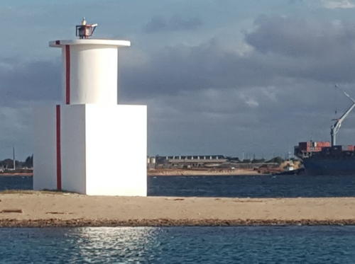
Date unknown. Active; focal plane 20 m (66 ft); quick-flashing white light. 9 m (29 ft) round cylindrical tower centered on a circular 1-story equipment room, painted white with a red vertical stripe on the range line. Wikimedia has the photo seen at right, Corrie Bornman has a 2016 photo, Eric Kija has a closeup, a 2009 photo is available, and Google has a satellite view. This is the Dar es Salaam approach range, guiding vessels around the north side of the Makatumbe reefs. Oyster Bay, on the north side of Dar es Salaam, was an area of European settlement in colonial times and is now an area of beach resorts. Located on the waterfront just off Kaunda Drive. Site status unknown. ARLHS TAN-005; Admiralty D6674; NGA 31436.
* Kinondoni (Oyster Bay) Range Rear
Date unknown. Active; focal plane 37 m (121 ft); quick-flashing white light. 26 m (85 ft) round cylindrical concrete tower. Tower painted white with a red vertical stripe on the range line. Google has a street view and a satellite view. Located on Kaunda Drive west of Kenyatta Drive, 400 m (1/4 mi) west southwest of the front light. Site open, tower closed. ARLHS TAN-006; Admiralty D6674.1; NGA 31440.
* Ferry Terminal Range Front (LM11)
Date unknown. Active; focal plane 17 m (56 ft); quick-flashing white light. 17 m (56 ft) square skeletal tower carrying a red triangular daymark, point up. Hassan Nassor has a photo, Rameez Esmail has a photo, and Google has a satellite view. This range guides vessels northward as they leave the inner harbor. Located just offshore at the main ferry terminal in downtown Dar es Salaam. Site open, tower closed. Admiralty D6698; NGA 31451.
* Ferry Terminal Range Rear (LM12)
Date unknown. Active; focal plane 25 m (82 ft); white light, 1 s on, 1 s off. Light on a mast atop the Tanzania Revenue Authority building on Samora Avenue, 255 m (837 ft) northwest of the front light. Jones Nde'kia has a photo showing various masts atop the building; it's not clear which one carries the light. Site open, tower closed. Admiralty D6698.1; NGA 31451.1.

Kinondoni (Oyster Bay) Range Front Light, Dar es Salaam, February 2017
Wikimedia Creative Commons photo by MISANA
Kurasini Range Front (LM5)
Date unknown. Active; focal plane 36 m (118 ft); quick-flashing white light. Approx. 31 m (102 ft) square skeletal tower carrying an orange triangular daymark, point up. No photo available but Google has a rooftop street view and a satellite view. This is the entrance range for Dar es Salaam harbor. The rear light (focal plane 44 m (144 ft), isophase white light) is located atop an office building adjacent to the port authority headquarters; Google has a satellite view. Located in a large dockyard in downtown Dar es Salaam. Site and tower closed. Admiralty D6694; NGA 31476.
Vijibweni Range Front (LM9)
Date unknown. Active; focal plane 21 m (69 ft); quick-flashing white light. Approx. 16 m (52 ft) skeletal tower. No photo available but Google has a satellite view. The range guides ships in the south harbor; it has the same line as the Ferry Terminal range in the opposite direction. Located at the end of the inner harbor. Site status unknown. Admiralty D6697; NGA 31453.
Vijibweni Range Rear (LM10)
Date unknown. Active; focal plane 27 m (89 ft); isophase white light, period unknown. Approx. 16 m (52 ft) skeletal tower. No photo available but Google has a satellite view. Located 100 m (330 ft) southeast of the front light. Site status unknown. Admiralty D6697.1; NGA 31453.1.
Minazi Mikinda Range Front
Date unknown. Active; focal plane about 12 m (39 ft); white light, pattern unknown. Approx. 10 m (33 ft) round barbell-shaped tower rising from a 1-story equipment building. The tower is painted with black and yellow horizontal bands. Gustav Noel has a photo and Google has a satellite view. This is the third approach range guiding vessels to the harbor. Located on the south side of the harbor entrance. Site status unknown. Admiralty D6686.

Kurasini Range Front Light, Dar es Salaam, August 2018
Google Maps photo by 360Panoramic Image
Minazi Mikinda Range Rear
Date unknown. Active; focal plane about 18 m (59 ft); white light, pattern unknown. Approx. 14 m (46 ft) round tower rising from a 1-story equipment building. The tower appears to be painted with black (?) and white horizontal bands. No photo available but Google has a satellite view. Located about 100 m (330 ft) southwest of the front light. Site status unknown. Admiralty D6686.1.
Ras Rangoni Range Front (LM3)
Date unknown. Active; focal plane 11 m (36 ft); quick-flashing white light. Approx. 9 m (30 ft) round concrete tower rising from a square 1-story base. No photo available but Google has an indistinct satellite view. This is the second approach range guiding vessels to the harbor. Located on Ras Rangoni, the cape on the south side of the entrance. Site status unknown. Admiralty D6684; NGA 31444.
Ras Rangoni Range Rear (LM4)
Date unknown. Active; focal plane 22 m (72 ft); isophase white light. Approx. 18 m (59 ft) skeletal tower. No photo available but Google has a satellite view. Located 260 m (285 yd) south of the front light. Site status unknown. Admiralty D6684.1; NGA 31448.

Southern Pwani Region Lighthouses
The Pwani Region surrounds Dar es Salaam and includes the central coast of Tanzania. The word pwani means "coast" in Swahili.

Ras Kanzi (2)
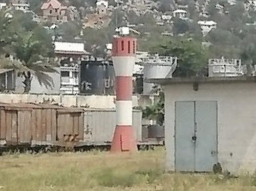
Date unknown (station established 1897). Active; focal plane 28 m (92 ft); white flash every 10 s. Approx. 12 m (40 ft) round hourglass-shaped white fiberglass tower colored with red and white horizontal bands. Amots Oko has a distant view (second thumbnail), Edwin Feruzi also has a distant view, and Google has a satellite view. Located adjacent to the ruined historic lighthouse. Admiralty D6668; NGA 31484.
Ras Kanzi (1)
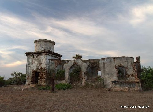
1897. Inactive and in ruins. Originally a 12 m (40 ft) gray square stucco-covered stone tower, attached to a keeper's house; all structures are in ruins, unroofed and collapsing. Jarle Naustvik's photo is at right and Bing has a good satellite view. Located on a promontory about 35 km (22 mi) southeast of Dar Es Salaam, marking the southern entrance to the Zanzibar Channel. Site open, tower open but dangerous. ARLHS TAN-008.
Nyororo (Niororo) Island
Date unknown (2012?). Active; focal plane about 13 m (43 ft); white flash every 10 s. 10 m (33 ft) round barbell-shaped fiberglass tower colored with red and white horizontal bands. Athuman Bakari has a 2020 closeup photo and Bing has a distant satellite view. Located on a small island about 25 km (15 mi) west of Ras Mkumbi (next entry). Accessible only by boat. Site open, tower closed. Admiralty D6667.
Ras Kanzi Light
Ras Kanzi Light ruins, Kidagaa Village
TripAdvisor (Lighthouse Beach Resort) Creative Commons photo by Jarle Naustvik
** Ras Mkumbi (Moresby Point, Mafia Island)
1894. Active; focal plane 31 m (102 ft); white flash every 5 s. 30 m (98 ft) square masonry tower with lantern and gallery, attached to a 1-story keeper's house. Lighthouse painted white with red horizontal bands on the upper half; the lantern dome is also painted red. Harry Davis's photo is at right, Matt Hinckley has a photo, Peter Byrne has a photo, Aali Sheikh has a 2021 photo, Gilbert Mushi has a 2023 photo, and Google has a satellite view of the station. Mafia Island is a 50 km (30 mi) long island off the southeast coast of Tanzania; it was under Arab control until it was purchased by Germany in 1890. Part of the island and the waters around the island are now incorporated in the Mafia Island Marine Park, and a number of resorts have been built on the island. The lighthouse is located on the northernmost tip of Mafia Island, accessible by 4WD. Site open; it is reported that the tower is open for climbing. . ARLHS TAN-011; Admiralty D6666; NGA 31492.
Fanjove Island (2)
1924 (station established 1894). Apparently reactivated (inactive from sometime after 1987 to sometime between 2015 and 2018); focal plane about 13 m (43 ft); white flash every 10 s. 17 m (55 ft) square tower with lantern and gallery rising from the center of a 1-story keeper's house. Lighthouse painted white. A 2012 photo and a second photo are available, Adam Moore has a 2019 street view from the beach, and Bing has a satellite view. The abandoned lighthouse was deteriorating rapidly and was clearly endangered; a 2015 photo shows its poor condition. However a 2018 photo by Johan Wessels shows the tower restored and apparently reactivated. The original lighthouse was a round, tapered tower. Located on a small island at the southern end of the Mafia group. Accessible only by boat. Site open, tower closed. ARLHS TAN-015; Admiralty D6659 (ex-D6662).
#Fanjove Island (3?)
Date unknown. Removed. This was a 10 m (33 ft) round barbell-shaped tower colored with black and white horizontal bands. The light is seen behind the the old lighthouse in a 2012 photo and a 2015 photo. In a 2021 photo by Katharina Marx the barbell-shaped tower has disappeared. Site open, tower closed.

Lindi Region Lighthouses
Rukyira Spit
Date unknown. Active; focal plane about 12 m (39 ft); white flash every 10 s. 10 m (33 ft) round fiberglass tower colored with black and white horizontal bands. No photo available but Google has a satellite view. Located on a sandy spit at the entrance to the small port of Kilwa Masoko. Probably accessible only by boat. Site status unknown. Admiralty D6658.

Ras Mkumbi Light, Mafia Island, October 2012
Wikimedia Creative Commons photo by Harry Davis
Ras Shuka
Date unknown. Active; focal plane 15 m (49 ft); white flash every 5 s. 6 m (20 ft) post attached to a square service building. No photo available but Google has a satellite view. Located on a promontory at the eastern entrance to Lindi Bay. Probably accessible only by boat. Site status unknown. Admiralty D6654; NGA 31500.

Mtwara Region Lighthouse
Mtwara Range Front (2?)
Date unknown. Active; focal plane 12 m (39 ft); quick-flashing white light. 9 m (30 ft) white concrete tower, upper part round and lower part square, with a red vertical stripe. No photo available but Google has a satellite view. NGA lists a skeletal tower. This is the entrance range for Mtwara, a small deepwater port in southernmost Tanzania. Located on the east side of harbor entrance. Site status unknown. Admiralty D6651; NGA 31520.
Mtwara Range Rear (2?)
Date unknown. Active; focal plane 19 m (62 ft); white flash every 2.5 s. 9 m (30 ft) white concrete tower, upper part round and lower part square, with a red vertical stripe. No photo available but Google has a satellite view. NGA lists a skeletal tower. Located 225 m (245 yd) southeast of the front light. Site status unknown. Admiralty D6651.1; NGA 31524.
Ras Jandoni Range Front
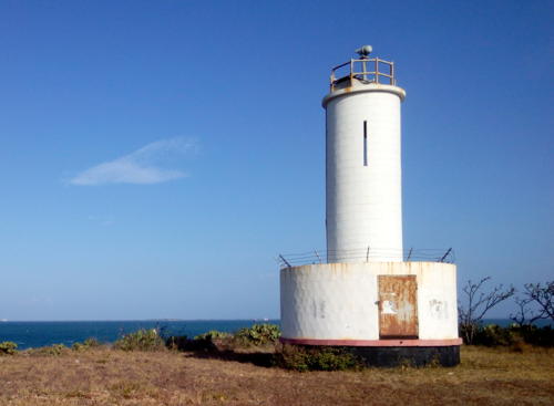
Date unknown. Active; focal plane 12 m (39 ft); white flash every 2 s. 9 m (30 ft) white concrete tower, upper part round and lower part square, with a red vertical stripe. Amin Ben Eshaq has the closeup photo seen at right and Google has a satellite view. This is the second range for Mtwara. Located on the east side of harbor entrance. Site status unknown. Admiralty D6653; NGA 31528.
Ras Jandoni Range Rear (2?)
Date unknown. Active; focal plane about 22 m (72 ft); two white flashes every 5 s. 12 m (39 ft) white concrete tower with a red vertical stripe. Faraji Benady has a very distant view and Google has a satellite view. The view also shows an older skeletal tower. Located on the mainland at the south end of the harbor, 715 m (0.44 mi) south of the front light. Site status unknown. Admiralty D6653.1; NGA 31532.
Ras Msangamkuu
Date unknown. Active; focal plane 26 m (85 ft); white flash every 10 s. 21 m (69 ft) square pyramidal skeletal tower, painted white. No photo available but the shadow of the tower is seen in Google's satellite view. Located on a sharp promontary at the eastern entrance to Mikindani Bay, about 10 km (6 mi) northeast of Mtwara in the far south of Tanzania. Site status unknown. ARLHS TAN-014; Admiralty D6650; NGA 31516.

Ras Jandoni Range Front Light, Mtwara, December 2017
Google Maps photo by Amin Ben Eshaq

Lake Victoria Lighthouses

Lake Victoria, the world's largest tropical lake, borders northwestern Tanzania, southern Uganda, and the southwestern corner of Kenya. The lake provides an important means of transportation between and within the three countries. In 2014 the Comarco Group received a contract to install lightbeacons at five locations on the lake in Tanzania, at Kisumu in Kenya, and at three locations in Uganda. Three of the five Tanzanian lighthouses are listed below; the lighthouses of Musoma, on the east coast of the lake, and Kemondo Bay on the west coast have not yet been located.

Bukoba Port
2015. Active; focal plane about 15 m (49 ft); light characteristics unknown. Approx. 11 m (36 ft) tower. No photo available but Google has a satellite view that probably locates the lighthouse (in front of the large square building). Bukoba is a city of about 145,000 residents on the southwest shore of the lake about 50 km (30 mi) south of the Ugandan border. Site status unknown.
Mwanza South Port
2015. Active; focal plane about 15 m (49 ft); light characteristics unknown. Approx. 11 m (36 ft) round barbell-shaped fiberglass tower colored with red and white horizontal bands. A photo by Gilbert Charles is at right and Google has a satellite view. Located at the southern end of Lake Victoria, Mwanza is a regional capital and the second largest city of Tanzania with a population of more than one million. Rail ferries arrive here from Jinja, Uganda, at the other end of the lake. The lighthouse is located at the rail ferry terminal. Site and tower closed.
Mwanza North Port
2015. Active; focal plane about 15 m (49 ft); light characteristics unknown. Approx. 11 m (36 ft) round barbell-shaped fiberglass tower colored with black and white horizontal bands. In Youngsan Lim's view from the lake the light can be seen near the foot of the pier (zoom in!) and Google has a satellite view. Nearby the improbably balanced Bismarck Rock is a well-known attraction. Located in the Kamanga Ferry Terminal, one of two ferry terminals in Mwanza's north port. Site status unknown.

South Port Light, Mwanza, October 2022
Google Maps photo by Gilbert Charles

Information available on lost lighthouses:

Notable faux lighthouses:

Adjoining pages: North: Kenya | South: Northern Mozambique | Southwest: Zambia | Northwest: Burundi

Return to the Lighthouse Directory index | Ratings key

Posted June 12, 2005. Checked and revised December 23, 2023. Lighthouses: 51. Site copyright 2023 Russ Rowlett and the University of North Carolina at Chapel Hill.