Lighthouses of Malawi

The Republic of Malawi is a landlocked country in Southeastern Africa, east of Zambia, south of Tanzania, and north of Mozambique. It was colonized by Britain under the name Nyasaland in 1891. From 1953 and 1963 it was included with Zambia and Zimbabwe in the Federation of Rhodesia and Nyasaland. After the Federation disbanded Malawi became an independent nation in 1964. Largely rural, Malawi is one of world's least-developed countries. It has a population of nearly 20 million.

Lake Malawi, Africa's third largest lake, occupies about 75% of Malawi's eastern boundary. It is long and narrow: roughly 570 km (350 mi) long north to south and generally 50-65 km (30-40 mi) wide. The lake drains southward through the Shire River, a tributary of the Zambezi River. Ferries provide transportation on the lake and there are many small fishing craft but cargo shipment is light. The most important port is Chipoka, on the southwest coast; it is the only port with a rail connection.

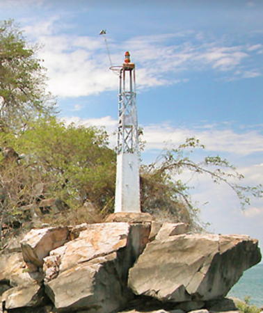
Navigation on the lake is guided by a series of small lighthouses sharing the design of the Nakantenga Island Light shown at right. We do not know the history of these lights, how many there are, or how and by whom they are maintained. This page lists several for which photos are available.

General Sources
Lake Malawi Locations
A large collection of photos posted by Malawi.si.
Political Map of Malawi
A useful map posted by NationsOnline.org.
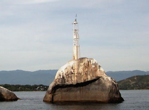

Mphanga Rocks Light, Chilumba, January 2007
Google Maps photo
by Ad Konings
Lighthouses
Mphanga Rocks
Date unknown. Active (?); focal plane about 15 m (49 ft); light pattern unknown. Approx. 8 m (26 ft) square white skeletal tower with an enclosed equipment cabinet in the base. Malawi.si has photos by Ad Konings and Pam Chin, one of Konings's photos is above, and Google has a distant satellite view of the rocks. Located about 3.2 km (2 mi) off the village of Chilumba on the northwest shore of the lake. Accessible only by boat. Site open, tower closed.
Penga Penga Island (Mbenji Islands)
Date unknown. Active (?); focal plane about 22 m (72 ft); light pattern unknown. Approx. 8 m (26 ft) square white skeletal tower with an enclosed equipment cabinet in the base. Malawi.si has photos by Ad Konings and Pete Barnes and Google has one of Konings's photos and a fuzzy satellite view. The Mbenji Islands are a group of small islands about 30 km (19 mi) northeast of the village of Chikhu on the west central coast of the lake. Accessible only by boat. Site open, tower closed.
Nankoma Island
Date unknown. Active (?); focal plane about 11 m (36 ft); light pattern unknown. Approx. 6 m (20 ft) square red tower. Donovan Callaghan has a photo, Nakul Patel has a street view, and Google has a fuzzy satellite view. Nankoma is the northernmost of the three Marelli Islands located just off the west coast of the lake about 25 km (15 mi) northeast of Chipoka. Located about 75 m (250 ft) off the northern tip of the island. Accessible only by boat but there's a good view from the Blue Zebra Island Lodge. Site open, tower closed.
Nakantenga Island
Date unknown. Active (?); focal plane about 16 m (52 ft); light pattern unknown. Approx. 8 m (26 ft) square white skeletal tower with an enclosed equipment cabinet in the base. A photo by Ad Konings is at right and Google has a distant satellite view. Nakantenga is the southernmost of the Marelli Islands. Located on the southeastern tip of the island. Accessible only by boat. Site open, tower closed.
Zimbawe Rock
Date unknown. Appears abandoned. Approx. 8 m (26 ft) square skeletal tower with an enclosed equipment cabinet in the base; the tower appeasr to be brown with rust. Malawi.si has photos by Pam Chin, Ad Konings, and Larry Johnson, B. van Dierendonck has a photo, and Google has a fuzzy satellite view. Located on a rock off Cape Maclear, the tip of a peninsula that shelters the east side of Kasankha Bay, a basin at the southwestern corner of the lake. Accessible only by boat. Site open, tower closed.

Nakantenga Island Light, Marelli Islands, November 2004
Google Maps photo
by Ad Konings

Information available on lost lighthouses:

Notable faux lighthouses:

Adjoining pages: North: Tanzania | East: Northern Mozambique | West: Zambia

Return to the Lighthouse Directory index | Ratings key

Posted November 20, 2021. Checked and revised January 22, 2024. Lighthouses: 5. Site copyright 2024 Russ Rowlett and the University of North Carolina at Chapel Hill.