Lighthouses of Norway: Central Trøndelag

The Kingdom of Norway (Norge in Norwegian) is one of the world's most maritime nations. The country is long and narrow, with drowned valleys called fjords that bring the sea far inland in most regions. The mainland coast is estimated to be 2650 km (1650 mi) long and when all the islands and minor indentations are counted the total coastline approaches an astonishing 60,000 km (37,500 mi), long enough the go around the world one and a half times. With such a lengthy and rocky shore it's not surprising that Norway has a large number of lighthouses.

Norway is divided into counties (fylker) and the counties are divided into municipalities (kommuner). This page lists lighthouses of the municipalities of Åfjord, Osen, Flatanger, and Namsos on the central coast of Trøndelag County north of Trondheim. It is one of four pages for this large county. Previously Åfjord and Osen were in Sør-Trøndelag County while Flatanger and Namsos were in Nord-Trøndelag. The two counties were merged in 2018 to form Trøndelag County.

In Norwegian a lighthouse is a fyrtårn (fire tower) or simply a fyr; a fyrlykt is a beacon and a lyktehus is a lantern. Øy is an island, holmen is an islet, skjær is a skerry (a tiny island or rocky reef), sund is a strait (often between an island and the mainland), bukt is a bay, nes is a headland, and havn is a harbor.

Aids to navigation in Norway are maintained by the Kystverket (Coast Directorate), an agency of the Ministry of Transport and Communications.

ARLHS numbers are from the ARLHS World List of Lights. NF numbers are from the Norsk Fyrliste. Admiralty numbers are from volume L of the Admiralty List of Lights & Fog Signals. U.S. NGA List numbers are from Publication 115.

General Sources
Norsk Fyrhistorisk Forening
News and photos from the Norwegian Lighthouse Association.
Online List of Lights - Norway
Photos by various photographers posted by Alexander Trabas. Many of the photos for this area are by Ronald Wöhrn, Michael Boucher or Arno Siering.
Lighthouse Pages from Anke and Jens - Norway
Excellent photos of more than 60 Norwegian lighthouses.
Norway's Fjorden and Lighthouses
Photos taken by Charles W. Bash on a 2010 cruise from Bergen to North Cape.
Leuchttürme an der norwegischen Küste
Photos posted by Bernd Claußen.
Lighthouses in Trøndelag
Photos by various photographers available from Wikimedia.
World of Lighthouses - Norway
Photos by various photographers available from Lightphotos.net.
Norwegische Leuchttürme auf historischen Postkarten
Historic postcard images posted by Klaus Huelse.
Norske Fyr
From Norwegian Wikipedia, a handy list of Norwegian light stations with their dates of establishment.
Norsk Fyrliste
The official Norwegian light list can be downloaded in six .pdf volumes.
GPSNavigationCharts
Navigational chart information for this section of the coast.
Navionics Charts
Navigation chart for Trøndelag.


Kya Light, Osen, June 2015
Wikimedia Creative Commons photo by Danckert Monrad-Krohn
for the Norwegian Culture Ministry

Åfjord Lighthouses
Strandaunskjæret
Date unknown. Active; focal plane 6 m (20 ft); white, red or green light depending on direction, 3 s on, 3 s off. 6 m (20 ft) square tower with lantern and gallery. Lighthouse painted white; lantern roof painted red. Google has a distant street view and Bing has a distant satellite view. Located on a skerry on the north side of the Åfjord about 1.6 km (1 mi) southwest of Monstad. Accessible only by boat. Site open, tower closed. NF-480500; Admiralty L1628; NGA 8332.
Smørholmskjæret
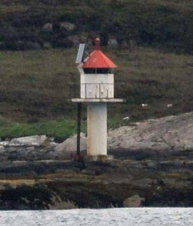
Date unknown. Active; focal plane 6 m (20 ft); white, red or green light depending on direction, 3 s on, 3 s off. 7 m (23 ft) lantern and gallery supported by piles. Lantern painted white with a red roof. Trabas has Boucher's photo and Google has a satellite view. Located on a skerry about 1.6 km (1 mi) west of Lauvøy. Accessible only by boat. Site open, tower closed. NF-479400; Admiralty L1616; NGA 8316.
Bingsholmråsa
Date unknown. Active; focal plane 5 m (17 ft); white, red or green light depending on direction, 3 s on, 3 s off. 7 m (23 ft) lantern and gallery supported by piles. Lantern painted white with a red roof. No photo available but Google has a satellite view. Located on a shoal off the northeastern tip of Lauvøy. Accessible only by boat. Site open, tower closed. NF-481000; Admiralty L1630; NGA 8336.
Synstskjæret (Sønstskjæret)
Date unknown. Active; focal plane 7.5 m (25 ft); white, red or green light depending on direction, occulting twice every 8 s. 8 m (26 ft) square skeletal tower with enclosed upper portion, lantern and gallery. Trabas has Siering's distant view and Bing has a satellite view. Located on the outermost of a group of skerries extending southwest from Linesøy. Accessible only by boat. Site open, tower closed. NF-481500; Admiralty L1636; NGA 8344.
Slåttøy
Date unknown. Active; focal plane 5.5 m (18 ft); white, red or green light depending on direction, 3 s on, 3 s off. 7 m (23 ft) concrete post with lantern and gallery. Trabas has Jim Smith's photo and Bing has a distant satellite view. Located on a skerry just off the east coast of Slåttøy, a smaller island off the southwest coast of Linesøy. Accessible only by boat. Site open, tower closed. NF-481600; Admiralty L1637; NGA 8352.

Smørholmskjæret Light, Åfjord, September 2011
photo copyright Michael Boucher; used by permission
Storskjæret
Date unknown. Active; focal plane 8 m (26 ft); white, red or green light depending on direction, occulting three times every 12 s. 8 m (26 ft) square square skeletal tower with enclosed upper portion, lantern and gallery. No photo available but Bing has an indistinct satellite view. Located on a skerry northwest of Linesøya. Accessible only by boat. Site open, tower closed. NF-482000; Admiralty L1640; NGA 8348.
Bruskjærbåan
Date unknown. Active; focal plane 5.5 m (18 ft); white, red or green light depending on direction, occulting three times every 12 s. 8 m (26 ft) lantern and gallery on tripod piles. Lantern painted white with a red roof. Trabas has Wöhrn's photo and Bing has a fuzzy satellite view. Located in the Linesfjord southeast of Linesøya. Accessible only by boat. Site open, tower closed. NF-482400; Admiralty L1642; NGA 8356.
Krokholmen
1924. Active; focal plane 5.5 m (18 ft); white, red or green light depending on direction, occulting twice every 8 s. 7 m (23 ft) square tower with lantern and gallery. Lighthouse painted white; lantern roof painted red. Trabas has Wöhrn's photo, a closeup is available. and Google has an indistinct satellite view. Located on a small island about 1.5 km (0.9 mi) southwest of the bridge. Accessible only by boat. Site open, tower closed. NF-483600; Admiralty L1656; NGA 8384.
Hosnaøyan
Date unknown. Active; focal plane 30 m (98 ft); flash every 5 s, white, red or green depending on direction. 8 m (26 ft) square tower with lantern and gallery. Lighthouse painted white; lantern roof painted red. A 2022 photo is available and Bing has a distant satellite view. Located on an island about 5 km (3 mi) northwest of Stokkøy. NGA lists this light as Hosenoyene. Accessible only by boat. Site open, tower closed. NF-484800; Admiralty L1670; NGA 8408.
Stokkneset (1) (?)
1924. Replaced in 2022. 7 m (23 ft) square tower with lantern and gallery. Lighthouse painted white; lantern roof painted red. Robert van Poppelen's photo is at right, Trabas has Wöhrn's closeup photo, another view is available (second photo on the page), and Google has a distant satellite view and a very distant street view from the bridge. This is (or was) one of Norway's most photographed small lighthouses because ferries and cruise ships must pass very close to it. The active light (red light, 2 s on, 2 s off) is now on a post. Located at the southeastern tip of the island of Stokkøya. Accessible only by boat. Site open, tower closed. ARLHS NOR-421; ex-NF-484200. Active light: NF-484202; Admiralty L1660; NGA 8392.

Stokkneset Light, Åfjord, February 2014
Google Maps photo by Robert van Poppelen
Skjærvikpynten
Date unknown (station established 1892). Active; focal plane 4 m (13 ft); white, red or green light depending on direction, occulting once every 6 s. 6 m (20 ft) lantern mounted on four straight piles. Lantern painted white with a red roof, piles black. Trabas has Wöhrn's closeup photo, Dominique Salé also has a photo, Herman Jelstad has a drone view, and Google has a distant satellite view. Located at the narrowest point of the Stokksund about 600 m (3/8 mi) northwest of the Stokkneset light. Accessible only by boat. Site open, tower closed. ARLHS NOR-420; NF-484400; Admiralty L1664; NGA 8400.
Marflesa
1897. Active; focal plane 7.5 m (25 ft); white, red or green light depending on direction, occulting twice every 8 s. 5.5 m (19 ft) stone cairn with lantern and gallery. Lantern painted white with a red roof. Trabas has Bash's photo, a view from the fjord is available, and Bing has a distant satellite view. Located on a skerry about 1 km (0.6 mi) west of Brandsøya. Accessible only by boat. Site open, tower closed. NF-485200; Admiralty L1674; NGA 8416.
Kaura
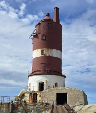
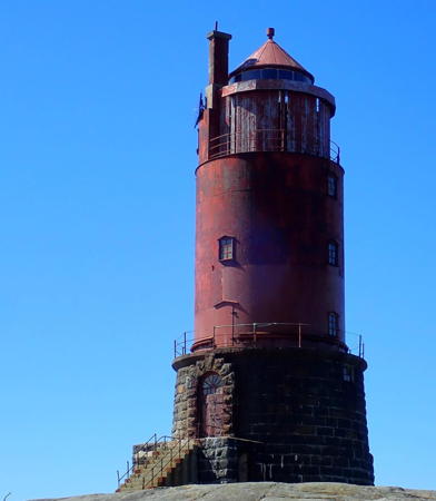
1931. Active; focal plane 30 m (98 ft); two flashes every 10 s, white, red or green depending on direction. 22 m (72 ft) round cylindrical cast iron tower with lantern and gallery, incorporating keeper's quarters, mounted on a round stone base. Lighthouse painted red with one narrow white horizontal band; stone base painted white. A concrete boathouse is connected to the lighthouse by a concrete bridge. Jan Erik Bangsund has the closeup photo seen at right, the Lighthouse Association has a page for the lighthouse, Trabas has Boucher's photo, Geir Ole Søreng has a good photo, Eric Kelly has a view from the sea, and Google has a satellite view. This design is the closest thing in Norway to the "sparkplug" cast iron lighthouses of the U.S. Sibling of Kya Fyr. The lighthouse is the last built of Norway's many cast iron lights. Located on a small skerry in the Norwegian Sea about 6 km (3.5 mi) northwest of Roan. Accessible only by boat. Site open, tower closed. . ARLHS NOR-135; NF-485800; Admiralty L1682; NGA 8432.
Terningen
Date unknown. Active; focal plane 7.5 m (25 ft); white, red or green light depending on direction, 3 s on, 3 s off. 4.5 m (15 ft) lantern mounted on a stone base. Lantern painted white with a red roof. Trabas has Wöhrn's photo and Bing has a distant satellite view. Not to be confused with the well-known Terningen lighthouse on Hitra. Located at the western tip of Terningen, an island on the south side of the entrance to the Bessakersund. Accessible only by boat. Site open, tower closed. NF-486200; Admiralty L1686; NGA 8444.

Kaura Light, Roan, July 2014
Google Maps photo by Jan Erik Bangsund

Osen Lighthouses
Ytterøyværet
Date unknown. Active; focal plane 12 m (39 ft); white, red or green light depending on direction, occulting three times every 12 s. 7 m (23 ft) square tower with lantern and gallery. Lighthouse painted white; lantern roof painted red. No photo available but Bing has a satellite view. Located on an island about 1 km (0.6 mi) west of Ytre Skjervøy. Accessible only by boat. Site open, tower closed. NF-487100; Admiralty L1694; NGA 8460.
Kya
1920. Active; focal plane 29 m (95 ft); white flash every 10 s. 23 m (75 ft) round cylindrical cast iron tower with lantern and gallery, incorporating keeper's quarters, mounted on a round stone base. Entire lighthouse painted red. Danckert Monrad-Krohn's photo is at the top of this page, the Lighthouse Association has a page for the lighthouse, a good closeup is available, Eric Kelly has a view from the sea, Trabas has Boucher's very distant view, and Bing has a satellite view. Not to be confused with another, less well known lighthouse in Frøya. This is one of the most exposed lighthouses of the Norwegian coast and despite its sturdy stone base it has suffered repeated storm damage over the years. It was a very difficult assignment for lightkeepers until the lighthouse was automated in 1958. Located on a tiny islet in the Norwegian Sea about 16 km (10 mi) northwest of Sandviksberget. Accessible only by boat. Site open, tower closed. . ARLHS NOR-147; NF-500000; Admiralty L1722; NGA 8548.
Søre Raudøya (Søre Rødøy, Sondre Rodoy) (Range Front)
Date unknown. Active; focal plane 14.5 m (48 ft); white, red or green light depending on direction, 1 s on, 1 s off. 7 m (23 ft) square tower with lantern and gallery. Lighthouse painted white; lantern roof painted red. No photo available but Bing has a distant satellite view. Located on the north point of Søre Raudøy, about 4 km (2.5 mi) southwest of Sætervågen. Accessible only by boat. Site open, tower closed. NF-489100; Admiralty L1716; NGA 8508.
* Sætervågen (South Breakwater)
Date unknown. Active; focal plane 7.5 m (25 ft); white, red or green light depending on direction, occulting once every 6 s. 6.5 m (21 ft) lantern mounted on a platform supported by four straightpiles. Lantern painted white, lantern roof red, piles black. Leif Buhaug has a closeup photo, Trabas has Jim Smith's photo, another photo is available, the light is seen at the right in Owen Morgan's aerial photo of the harbor and Google has a satellite view. Located at the end of the main breakwater mole of Sætervågen, a village about 2.5 km (1.5 mi) southeast of the Buholmråsa lighthouse. Accessible by walking the pier. Site open, tower closed. NF-488500; Admiralty L1708; NGA 8500.
Saksa
Date unknown. Active; focal plane 7.5 m (25 ft); white, red or green light depending on direction, occulting three times every 12 s. 8.5 m (28 ft) lantern and gallery on a short skeletal tower mounted on piles. Lantern painted white, lantern roof red. Trabas has Wöhrn's photo and Bing has a distant satellite view. Located on a skerry about 1.5 km (1 mi) west of the Buholmråsa lighthouse. Accessible only by boat. Site open, tower closed. NF-489600; Admiralty L1718; NGA 8520.
Buholmråsa
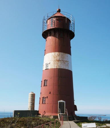
1917. Active; focal plane 36 m (118 ft); white, red or green light depending on direction, occulting once every 6 s. 23 m (75 ft) round cast iron tower with lantern and gallery, painted red with one white horizontal band. Two 1-1/2-story keeper's houses. Olga Tingstedt's photo is at right, Trabas has Wöhrn's photo, Claußen has a photo, Gunnar Storheim has a nice view from the sea, Bash also has a view from the sea, Åsa Karin Aronsen has a 2021 closeup, and Google has a distant satellite view. The houses are available for overnight accommodations. Air raids during World War II damaged several of the buildings at this station, which marks the entrance to the Svefjord. Located on a small island off the end of a peninsula about 4 km (2.5 mi) north of Sandviksberget. Accessible only by boat. Site open, tower closed. Site manager: Buholmråsa Fyr. . ARLHS NOR-063; NF-489700; Admiralty L1720; NGA 8524.

Buholmråsa Light, Osen, May 2023
Instagram photo by olgatingstedt

Flatanger Lighthouses
Leiskjæret
Date unknown. Active; focal plane 8 m (26 ft); white, red or green light depending on direction, 3 s on, 3 s off. 8 m (26 ft) lantern supported by piles. Lantern painted white with a red roof. No photo available but Google has a satellite view. This was originally the rear light of the Oterskjæret Range. Located on a skerry about 6 km (3.5 mi) west of Villa. Accessible only by boat. Site open, tower closed. NF-501500; Admiralty L1726; NGA 8528.1.
Trollsteinodden
Date unknown. Active; focal plane 21.5 m (71 ft); flash every 5 s, white, red or green depending on direction. 6 m (20 ft) square skeletal tower, covered with siding, with lantern and gallery. Lighthouse painted white, lantern roof red. No photo available but Google has a satellite view. Located on the southwestern point of Kvaløya, an island off Flatanger. Accessible only by boat. Site status unknown. NF-505000; Admiralty L1732; NGA 8564.
Krokholmen (1) (?)
Date unknown. Replaced and probably removed. 6 m (20 ft) lantern mounted on a platform supported by piles. Lantern painted white with a red roof. Bing has a satellite view. The active light (focal plane 5 m (16 ft); green light, 1 s on, 1 s off) is on a post. Located on a skerry about 1 km (0.6 mi) west of Villa. Accessible only by boat. Site open, tower closed. ex-NF-506200; Active light: NF-506203; Admiralty L1737; NGA 8580.
Villa
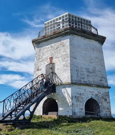
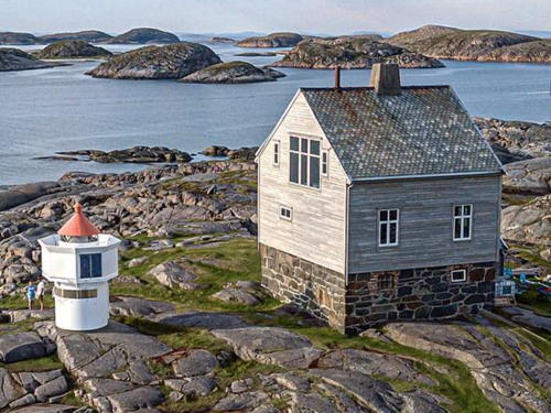
1839. Inactive since 1890. 15 m (49 ft) hexagonal cylindrical granite tower; an observation room has been built atop the tower. The tower is unpainted stone. Eirik Solheim's photo is at right, Arve Andersen has a 2020 photo, Lars Forseth has a 2006 photo, Flatanger Kommune has a page for the lighthouse, Magnus Harbak Nordvik has a nice view, and Google has a satellite view. This was the first lighthouse built north of Trondheimfjord. It was designed to burn coal and did so until it was converted to oil in 1859. A friends group, Villa Fyr Venneforening, was formed in 1976 and signed an agreement with the Kystverket to take over management of the building. Ownership was transferred to Flatanger Kommune in 2005 and later to the friends group. An assistant keeper's house has been renovated for overnight accommodations. The restoration seen in Solheim's photo took place in 2015; a modern observation room was added atop the tower. Located on an island off Flatanger. Accessible only by boat. Site and tower open. Owner/site manager: Villa Fyr Venneforening . ARLHS NOR-276.

Villa Light, Flatanger, June 2016
Wikimedia Creative Commons photo by Eirik Solheim
Ellingråsa (Ellingsråsa) (1)
1888. Inactive since 2001. 10 m (33 ft) 1-1/2 story wood keeper's house. The house is painted white. The light was shown through the window seen in the Culture Ministry photo at right. Magnus Harbak Nordvik has a view from the sea, another view is available, and Google has a satellite view. The station was purchased by Flatanger Kommune in 2005, and accommodations are now available. Located on the north coast of Byørøy, marking the passage between that island and Ellingen, about 5 km (3 mi) northwest of Lauvsnes. Site open, tower closed. Owner: Flatanger Kommune. Site manager: Ellingråsa Lighthouse Lodge. . ARLHS NOR-071.
Ellingråsa (Ellingsråsa) (2)
Date unknown. Active; focal plane 22 m (72 ft); two flashes every 5 s, white, red or green depending on direction. 6 m (20 ft) square skeletal tower, covered with siding, with lantern and gallery. Lighthouse painted white, lantern roof red. A closeup photo is available and Lighthouse Lodge has photos showing the new lighthouse. Located in front of the historic building. Site open, tower closed. Site manager: Ellingråsa Lighthouse Lodge. NF-509100; Admiralty L1750; NGA 8672.
Feøya
Date unknown. Active; focal plane 9 m (30 ft); white, red or green light depending on direction, 3 s on, 3 s off. 6 m (20 ft) square skeletal tower, covered with siding, with lantern and gallery. Lighthouse painted white, lantern roof red. No photo available but Google has a satellite view. Located on the northwest point of Feøy. Accessible only by boat. Site open, tower closed. NF-509000; Admiralty L1749; NGA 8668.
Ellingråsa Fyr
Ellingråsa Light, Flatanger
Norwegian Culture Ministry photo
Skjevillen
Date unknown. Active; focal plane 5.5 m (19 ft); white, red or green light, depending on direction, occulting twice every 8 s. 6.5 m (21 ft) lantern supported by piles. Lantern painted white with a red roof. No photo available but Bing has a distant satellite view. Located on a reef off the north coast of Asholmen. Accessible only by boat. Site open, tower closed. NF-509700; Admiralty L1756; NGA 8684.

Namsos Lighthouses
Flotra
Date unknown. Active; focal plane 16.5 m (54 ft); flash every 5 s, white, red or green depending on direction. 6 m (20 ft) skeletal tower with lantern and gallery. Lantern painted white with a red roof. Petter Hamnes has a distant photo and Bing has a distant satellite view. Located on a small island about 6.5 km (4 mi) northeast of Utvorda. Accessible only by boat. Site open, tower closed. NF-510500; Admiralty L1764; NGA 8692.
Bangsund
Date unknown. Active; focal plane 7 m (23 ft); white, red or green light depending on direction, 3 s on, 3 s off. 6 m (20 ft) square skeletal tower with lantern and gallery, covered with siding. Lighthouse painted white; lantern roof is red. No photo available but Google has a distant satellite view. Located on Brandøy, an island in the Lyngynfjord, marking the entrance to Bangsund. Accessible only by boat. Site open, tower closed. NF-512200; Admiralty L1774; NGA 8708.
Digerneset
Date unknown. Active; focal plane 7 m (23 ft); two flashes every 5 s, white, red or green depending on direction. 4 m (13 ft) lantern on a stone base with snow screen. Lantern painted white with a red roof. A photo by Andreas Köhler is at right, Trabas also has Köhler's photo, Erik Stenvik has a distant view from Namsos and Bing has a distant satellite view. Located on a promontory on the south side of the Namsen sound, about 1.6 km (1 mi) south of the Namsos waterfront. Site status unknown. NF-512400; Admiralty L1775.
Levra
Date unknown. Active; focal plane 7.5 m (25 ft); white, red or green light depending on direction, occulting twice every 8 s. 6 m (20 ft) lantern mounted on a platform supported by piles. Lantern painted white with a red roof. Trabas has Köhler's photo and Bing has a distant satellite view. Located on a skerry in the Surviksfjord. Accessible only by boat. Site open, tower closed. NF-513000; Admiralty L1778; NGA 8716.

Digerneset Light, Namsos, August 2019
photo copyright Andreas Köhler; used by permission

Information available on lost lighthouses:

Notable faux lighthouses:

Adjoining pages: North: Northern Trøndelag | South: Trondheim Area

Return to the Lighthouse Directory index | Ratings key

Posted August 3, 2006. Checked and revised July 5, 2023. Lighthouses: 32. Site copyright 2023 Russ Rowlett and the University of North Carolina at Chapel Hill.