Lighthouses of Canada: Nunavut and Northern Québec

The nation of Canada was created by the British North America Act in 1867 with Ontario, Québec, New Brunswick, and Nova Scotia as the four original provinces. At that time the Hudson's Bay Company controlled the northern territories of modern Canada; these holdings were transferred to the new Canadian confederation in 1870. After creation of new provinces and many boundary adjustments, Canada today is a federation of ten provinces and three large federal territories in the north of the country.

Nunavut is a territory encompassing the eastern portion of the Canadian Arctic. Separated from the Northwest Territories in 1999, Nunavut is thinly populated; its population in 2023 was estimated to be a little over 40,000. Iqaluit (formerly called Frobisher Bay) is the capital of the territory.

Commercial navigation began in these northern waters after a railroad was completed in 1929 to Churchill, Manitoba, on the southwestern shore of Hudson Bay. This allowed Canadian farmers to ship grain to Europe via Hudson Bay and Hudson Strait. In 1932 a series of skeletal lighthouses were built to improve the safety of navigation through the strait.

Also included on this page are several lights of Nunavik, Québec's northern territory, which faces Nunavut across the Hudson Strait.

Aids to navigation in Canada are maintained by the Canadian Coast Guard. In 2008, Parliament passed the Heritage Lighthouse Protection Act to designate and protect historic lighthouses.

ARLHS numbers are from the ARLHS World List of Lights. CCG numbers are from the Inland Waters list of the List of Lights, Buoys, and Fog Signals of Fisheries and Oceans Canada. Admiralty numbers are from Volume H of the Admiralty List of Lights & Fog Signals. U.S. NGA numbers are from Publication 110.

General Sources
Online List of Lights - Northern and Eastern Canada
Photos by various photographers posted by Alexander Trabas.
List of Lights, Buoys, and Fog Signals
Official Canadian light lists.
GPSNauticalCharts
Navigational chart information for Hudson Strait.
Navionics Charts
Navigation chart for Frobisher Bay and Nunavut.


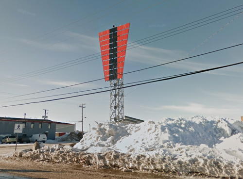
Koojesse Inlet Range Rear Light, Iqaliut, March 2013
Google Maps street view
Nunavut Lighthouses

Baffin Island Lighthouses

Baffin Island (Qikiqtaaluk) is the largest island of Canada and fifth largest island of the world. To the northeast Baffin Island faces Greenland across the Davis Strait and Baffin Bay; to the south it faces northernmost Québec across the Hudson Strait.
* Koojesse Inlet Range Front
Date unknown. Active; focal plane 13 m (43 ft); continuous green light. 13 m (43 ft) square skeletal tower carrying a daymark colored orange with a black vertical stripe. Tim Van Horn has a photo of the two range lights (second photo on the page), Google has a street view and Google has a satellite view. This is the final approach range for Iqaluit, the capital of Nunavut. Located on the town's waterfront. Site open, tower closed. CCG I-2585; Admiralty H0056.2; NGA 0652.
* Koojesse Inlet Range Rear
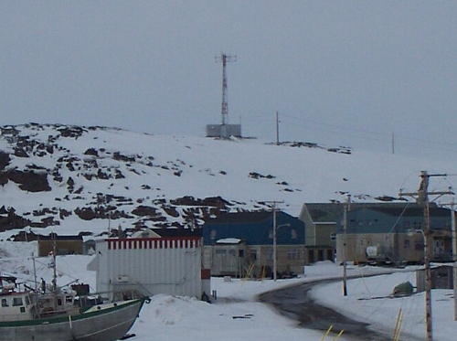
Date unknown. Active; focal plane 30.5 m (100 ft); continuous green light. 16.5 m (53 ft) square skeletal tower carrying a daymark colored orange with a black vertical stripe. Google has a closeup street view (also seen at the top of this page), Tim Van Horn has a photo of the two range lights (second photo on the page), and Google has a satellite view. Located at the intersection of Mivvik Street and Iglulik Drive in the center of Iqaluit. Site open, tower closed. CCG I-2586; Admiralty H0056.21; NGA 0656.
* Black Ledge Range Front
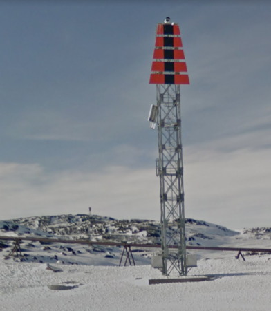
Date unknown. Active; focal plane 18.5 m (60 ft); red light, 1 s on, 1 s off, visible only on the range line. 17 m (56 ft) square skeletal tower carrying a daymark colored orange with a black vertical stripe. Casey Lessard has a 2022 street view and Google has the closeup street view at right and a satellite view. This range guides ships to the commercial docks for Iqaluit. The rear light (seen in the background of the street view) is on an 8.5 m (28 ft) skeletal tower on a hilltop 576 m (0.36 mi) to the west. Located on the west side of Koojesse Inlet about 2.5 km (1.5 mi) south of the town. Accessible by road. Site open, tower closed. CCG I-2582; Admiralty H0055.5; NGA 0657.
Monument Island
Date unknown. Active; focal plane 41.5 m (136 ft); red flash every 6 s. 9.5 m (31 ft) square skeletal tower carrying an ornge rectangular daymark. Google has a satellite view and a very distant street view. Located atop an island on the west side of the approach to Iqaluit and about 8 km (5 mi) south of town. Accessible only boat. Site open, tower closed. CCG I-2576; Admiralty H0056.4; NGA 0648.

Black Ledge Range Front Light, Iqaluit, March 2013
Google Maps street view
Resolute Lighthouses
Resolute (Qausuittuq) is a small Inuit community, population 183 in the 2021 census, on the south side of Cornwallis Island in Canada's high Arctic. The island is on the north side of the Parry Channel, a passage through Canada's Arctic Archipelago. The village is on the south side of the island facing Resolute Bay. These range lights are Canada's northernmost lights.

Resolute Bay Range Front
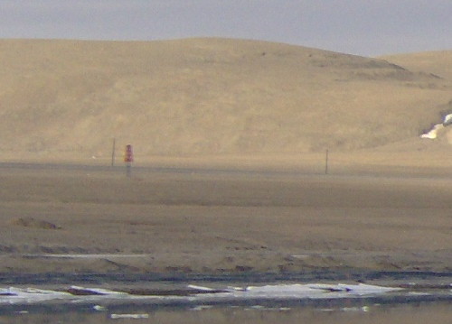
Date unknown. Active; focal plane 47 m (154 ft); white light, 1 s on, 1 s off. 13.5 m (45 ft) square skeletal tower carrying a trapezoidal daymark colored orange with a black vertical stripe. A distant view is at right and the shadow of the light is seen in Google's satellite view. This is the entrance range for Resolute Bay. Located about 2 km (1.25 mi) south of the village. Site open, tower closed. CCG I-2530; Admiralty H0014.8; NGA 0768.
Resolute Bay Range Rear
Date unknown. Active; focal plane 66 m (217 ft); white light, 1 s on, 1 s off. 8.5 m (28 ft) square skeletal tower carrying a trapezoidal daymark colored orange with a black vertical stripe. No photo available but the shadow of the light is seen in Google's satellite view. Located 304 m (1000 ft) north northeast of the front light. Site open, tower closed. CCG I-2531; Admiralty H0014.81; NGA 0772.

Resolute Bay Range Front Light, Resolute, July 2007
ex-Panoramio Creative Commons photo by tadilman

Kugaaruk Lighthouses
Kugaaruk (Pelly Bay) is an Inuit village of about 1000 residents facing Pelly Bay on the west side of the Simpson Peninsula of the mainland west of Baffin Island in the northwest of Nunavut.

Pelly Bay Range Front
Date unknown. Active; focal plane 11 m (36 ft); coninuous green light. Approx. 9 m (30 ft) square skeletal tower carrying a daymark colored orange with a black vertical stripe. No photo available but Google has an indistinct satellite view. The range guides ships on their final approach to Kugaaruk. The rear light is on a shorter skeletal tower 267 m (875 ft) to the southeast. Located on the shore about 400 m (1/4 mi) south of the town. Site open, tower closed. CCG I-2539; Admiralty H0014.6.
Simik Island Range Front
Date unknown. Active; focal plane 13.5 m (45 ft); coninuous red light. Approx. 10 m (33 ft) square skeletal tower carrying a daymark colored orange with a black vertical stripe. No photo available but Google has an indistinct satellite view. The range guides ships around Simik Island in the inital approach to Kugaaruk. The rear light is on a shorter skeletal tower 108 m (350 ft) to the east. Located on the shore about 2 km (1.25 mi) northwest of the town. Accessible only by boat. Site open, tower closed. CCG I-2535; Admiralty H0014.52.

Cambridge Bay Lighthouse
Cambridge Bay (Iqaluktuuttiaq) is an Inuit village of about 1800 residents on the south side of Victoria Island in the far northwest of Nunavut. The town is at the head of the bay for which it is named, an inlet of the Dease Strait, a link in the fabled Northwest Passage through the Canadian Arctic.

Canbridge Bay Range 2 Front
Date unknown. Active; focal plane 10 m (33 ft); coninuous yellow light. 9 m (30 ft) square skeletal tower carrying a daymark colored red with a white vertical stripe. No photo available but Google has a satellite view. The range guides ships northward in lower Cambridge Bay. The rear light is on a 6 m (20 ft) tripod tower on the mainland 479 m (0.3 mi) to the north. Located on a small island at the sharp westward bend of the bay. Accessible only by boat. Site open, tower closed. CCG I-2522; Admiralty H0013.84; NGA 0784.

Northern Hudson Bay Lighthouses
Bear Island
Date unknown (station established 1943). Active; focal plane 20 m (66 ft); white flash every 5 s. 12 m (39 ft) square skeletal tower carrying a rectangular orange daymark. No photo available but Google has a satellite view. Located on an island on the east side of the entrance to South (Munn) Bay, a sheltered embayment on the south side of Southampton Island. Accessible only by boat. Site status unknown. CCG I-2545; Admiralty H0034; NGA 0728.
Munn Bay (Coral Harbour, Salliq)
Date unknown (station established 1943). Active; focal plane 21 m (69 ft); white flash every 5 s. 11.5 m (38 ft) square skeletal tower carrying a rectangular orange daymark. No photo available but Google has a satellite view. Coral Harbour (Salliq), named for fossilized coral found in the area, is a Inuit village with about 850 inhabitants. Located on a slope about 6.5 km (4 mi) west of the village. Accessible by road or snowmobile. Site open, tower closed. CCG I-2546; Admiralty H0035; NGA 0732.

Western Hudson Bay Lighthouse (see also Manitoba)
Dunne Foxe Island
Date unknown. Active; focal plane 22 m (72 ft); white flash every 6 s. 10 m (33 ft) square skeletal tower. No photo available but Bing has a satellite view. Located on an island about 25 km (15 mi) northeast of the village of Whale Cove. Accessible only by boat. Site status unknown. CCG I-2601; Admiralty H0024; NGA 0740.
Walrus Island
Date unknown. Active; focal plane 28.5 m (95 ft); white flash every 6 s. 11 m (36 ft) square skeletal tower carrying an orange rectangular daymark. No photo available but Bing has a satellite view. Located on an island about 30 km (19 mi) south of the Dunne Foxe Island light. Accessible only by boat. Site status unknown. CCG I-2602; Admiralty H0025; NGA 0744.
Sentry Island
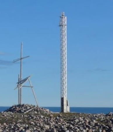
Date unknown. Active; focal plane 35.5 m (116 ft); white flash every 6 s. 18.5 m (61 ft) square white skeletal mast. Werner Müller's photo is at right and Google has a distant satellite view. This light guides ships to Arviat, a predominantly Inuit town of about 2500 residents on the west shore of Hudson Bay. Located on an island just off the northwestern coast of Hudson Bay about 15 km (9 mi) northeast of Arviat. Accessible only by boat. Site status unknown. CCG I-2603; Admiralty H0025.5; NGA 0746.

Sentry Island Light, Arviat, February 2021
Google Maps photo by Werner Müller

Eastern Hudson Bay Lighthouses
Broomfield Island (Sainsbury Point)
Date unknown. Active; focal plane 44 m (144 ft); red flash every 6 s. Square skeletal tower carrying a rectangular orange daymark. The height of the tower is not listed, but a tall tower would be required here. No photo available but the shadow of the light is seen in Bing's snowy satellite view. This light is near the southern end of the Belcher Islands, an archipelago in the southeastern corner of Hudson Bay, north of James Bay. Accessible only by boat. Site status unknown. CCG I-2552; Admiralty H0036.4; NGA 0714.
Cape Acadia
Date unknown. Active; focal plane 23.5 m (77 ft); white flash every 5 s. 19 m (62 ft) square skeletal tower carrying a rectangular orange daymark. No photo available but Google has the satellite view seen at right. Located at the southern tip of Mansel Island, a large island off the northwestern corner of Québec, in the entrance to Hudson Bay. Accessible only by boat. Site status unknown. CCG I-2551; Admiralty H0036.1; NGA 0712.
Mansel Island
Date unknown. Active; focal plane 18.5 m (60 ft); white flash every 5 s. 15.5 m (51 ft) square skeletal tower carrying a rectangular orange daymark. No photo available and Google has only a fuzzy satellite view of the location. Located at the northern tip of the island. Accessible only by boat. Site status unknown. CCG I-2550; Admiralty H0036; NGA 0708.
Coats Island (Carys Swan Nest)
Date unknown (station established 1932). Active; focal plane 12.5 m (41 ft); white flash every 6 s. 11.5 m (37 ft) square skeletal tower carrying a rectangular orange daymark. No photo available but Google has an indistinct satellite view. Coats Island is a large island about 130 km (80 mi) northwest of Mansel Island; the shipping route into or out of Hudson Bay passes between the two islands. Located at the southeastern tip of the island. Accessible only by boat. Site status unknown. CCG I-2549; Admiralty H0032; NGA 0716.
Cape Pembroke
Date unknown (station established 1968). Active; focal plane 16.5 m (54 ft); white flash every 5 s. 11 m (36 ft) square skeletal tower carrying a rectangular orange daymark. No photo available and Google has only a fuzzy satellite view of the location. Located at the northeastern tip of the Coats Island. Accessible only by boat. Site status unknown. CCG I-2548; Admiralty H0033; NGA 0720.
 

Cape Acadia Light, Mansel Island
Google Maps satellite view

Hudson Strait Lighthouses
Digges Islet
Date unknown (station established 1932). Active; focal plane 27.5 m (90 ft); white flash every 6 s. 8 m (26 ft) square skeletal tower carrying a square orange daymark. No photo available and Google has only a fuzzy satellite view of the location. Digges Islet is on the south side of the entrance to Hudson Strait from Hudson Bay. Located on the northern tip of the island. Accessible only by boat. Site status unknown. CCG I-2553; Admiralty H0038; NGA 0704.
Nottingham Island
Date unknown (station established 1932). Active; focal plane 27.5 m (90 ft); white flash every 6 s. 12.5 m (41 ft) square skeletal tower carrying a rectangular orange daymark with a black vertical stripe. No photo available and Google has only a fuzzy satellite view of the location. Nottingham Island is on the north side of the entrance to Hudson Strait from Hudson Bay, opposite the Digges Islet Light. Located on the southern tip of the island. Accessible only by boat. Site status unknown. CCG I-2554; Admiralty H0040; NGA 0700.
Charles Island West End
Date unknown (station established 1932). Active; focal plane 21 m (69 ft); white flash every 6 s. 16 m (52 ft) square skeletal tower carrying a rectangular orange daymark. No photo available and Google has only a fuzzy satellite view of the location. Charles Island is off Cap de Nouvelle-France on the south side of Hudson Strait. Located on the western tip of the island. Accessible only by boat. Site status unknown. CCG I-2556; Admiralty H0042; NGA 0676.
[Wales Island]
Date unknown (station established 1932). Active; focal plane 83 m (272 ft); white flash every 6 s. 7 m (23 ft) square skeletal mast carrying a rectangular orange daymark. No photo available and Google has only a fuzzy satellite view of the location. Located on the eastern tip of Wales Island, an island just off the Québec coast on the south side of Hudson Strait. CCG I-2558; Admiralty H0048; NGA 0668.

Northern Québec (Nunavik) Lighthouses

The vast territory of Québec north of latitude 55° is known as Nunavik. This area was governed as the Ungava District of the Northwest Territories until it was transferred to Québec in 1912. In 1975 the Québec government and Inuit leaders signed the James Bay and Northern Québec Agreement; one of its provisions created a regional government for Kativik, which includes all of Nunavik except a small Cree enclave in the southwest of the area.

Hudson Strait Lighthouse
Cape Hopes Advance
Date unknown (station established 1932). Active; focal plane 82.5 m (270 ft); white flash every 6 s. Approx. 7 m (23 ft) square skeletal tower painted with red and white horizontal bands. A distant view is at right and Google has an indistinct satellite view. Located about 10 km (6 mi) northwest of the Inuit village of Quactac marking a very prominent cape on the south side of the strait at the western entrance to Ungava Bay. Site status unknown. CCG I-2560; Admiralty H0052; NGA 0660.

Ungava Bay Lighthouses
Koksoak River Range Rear
Date unknown. Active; focal plane 39.5 m (130 ft); continuous green light visible only on the range line. 24.5 m (80 ft) square skeletal tower carrying a daymark colored orange with a black vertical stripe. No photo available but Google has a satellite view. The Koksoak River drains a large part of northern Québec. It is navigable to Kuujjuaq, the capital of Kativik, about 48 km (30 mi) from the mouth. Located on heights above the west side of the river about 15 km (9 mi) from the mouth. Site status unknown. CCG I-2592; Admiralty H0058.1; NGA 0601.1.
Koksoak River East Range Rear
Date unknown. Active; focal plane 35 m (115 ft); white light, 1 s on, 1 s off, visible only on the range line. 20 m (66 ft) skeletal mast carrying a large triangular daymark colored orange with a black vertical stripe. No photo available but Google has a satellite view. Located on heights above the east side of the river about 5 km (3 mi) from the mouth. Site status unknown. CCG I-2594; Admiralty H0058.41; NGA 0602.1.

Cape Hopes Advance Light, Quactac
Mapcarta Creative Commons photo by Golgo12

Information available on lost lighthouses:

Notable faux lighthouses:

Adjoining pages: East: Greenland | Southeast: Labrador | West: Northwest Territories

Return to the Lighthouse Directory index | Ratings key

Posted August 13, 2014. Checked and revised June 18, 2024. Lighthouses: 25. Site copyright 2024 Russ Rowlett and the University of North Carolina at Chapel Hill.