Lighthouses of Canada: Labrador and Belle Isle

Labrador is the mainland region of the Canadian province of Newfoundland and Labrador. Separated from the island of Newfoundland by the Strait of Belle Isle, the coast of Labrador stretches northwestward for some 1500 km (900 mi). Facing the Labrador Sea, an arm of the North Atlantic Ocean, the coast is rugged and indented with deep fjords and harbors. Settled communities with roads and lighthouses are found only on the southern section of the territory.

Britain transferred Labrador from its Québec colony (then called Lower Canada) to its Newfoundland colony in 1809. Newfoundland became a self-governing dominion under the British Crown in 1907 but gave up its dominion status in 1934, during the Great Depression. Newfoundland then joined Canada as the tenth province in 1949 following a referendum the previous year. The name of the province was changed from Newfoundland to Newfoundland and Labrador in 2001.

This page includes the lighthouses of Belle Isle, the island for which the strait is named. Since Labrador is an integral part of the province and does not have a separate administrative identity it's not clear whether Belle Isle should be considered part of Labrador or not. However, from the navigator's point of view the Belle Isle lighthouses fit in sequence with the lighthouses of the Labrador coast.

The south coast of Labrador is accessible from May through December by car ferry from St. Barbe, Newfoundland, to Blanc Sablon, Québec. In addition, Nunatsiavut Marine offers car ferry service from Corner Brook to Blanc Sablon and passenger ferry service along the Labrador coast. The Trans-Labrador Highway crosses southern Labrador, connecting the community of Happy Valley-Goose Bay in central Labrador to Québec and to the communities of the south coast. Paving of the highway was completed in 2022.

ARLHS numbers are from the ARLHS World List of Lights. CCG numbers are from the Newfoundland volume of the List of Lights, Buoys, and Fog Signals of Fisheries and Oceans Canada. Admiralty numbers are from Volume H of the Admiralty List of Lights & Fog Signals. U.S. NGA numbers are from Publication 110.

General Sources
Newfoundland Canada Lighthouses
Photos and notes by Kraig Anderson.
Lighthouses in Newfoundland and Labrador
Photos by various photographers available from Wikimedia.
Online List of Lights - Northern and Eastern Canada
Photos by various photographers posted by Alexander Trabas.
Leuchttürme Kanadas auf historischen Postkarten
Historic postcard views posted by Klaus Huelse.
List of Lights, Buoys, and Fog Signals
Official Canadian light lists.
GPSNauticalCharts
Navigational information for Labrador.
Navionics Charts
Navigational information for Labrador.


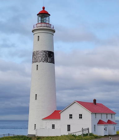
Point Amour Light, L'Anse Amour, July 2022
Google Maps photo by Corinne Gaudet

Hamilton Inlet Lighthouses
Hamilton Inlet is a nearly 150 km (90 mi) long, fjord-like inlet in southern Labrador. The western half of the inlet is a large basin called Lake Melville. The inlet leads to the town of Happy Valley-Goose Bay, which has a population of about 8000 and is the second largest settlement in Labrador.

South Wolf Island
Date unknown. Active; focal plane 88 m (289 ft); white flash every 6 s. 14 m (46 ft) skeletal tower. No photo available but Google has a distant satellite view. Much taller than most lights of the Labrador coast, this light serves as a landfall light for Hamilton Inlet. Located on the northeastern coast of South Wolf Island, about 40 km (25 mi) southeast of the entrance to the Inlet. Accessible only by boat. Site status unknown. CCG N-283; Admiralty H0081; NGA 0920
* Rigolet
Date unknown. Active; focal plane 12.5 m (41 ft); white flash every 4 s. 9 m (30 ft) square cylindrical skeletal tower. No photo available and the light is hard to distimguish in Google's satellite view. Rigolet is an Inuit village on the west side of a narrow section of the Inlet leading to Lake Melville. Located on the waterfront south of the docks. Site open, tower closed. CCG N-291; Admiralty H0075.6.
Kenamu River Range Rear
Date unknown. Active; focal plane 19 m (62 ft); green light occulting once every 6 s. 19 m (62 ft) square skeletal tower carrying a trapezoidal daymark painted white with a red vertical stripe. No photo available but Google has a distant satellite view. This range guides vessels leaving the Terrington docks across Lake Melville. Located on the north side of the mouth of the Kenamu River, which flows into the south side of Hamilton Inlet just west of Lake Melville. Site open, tower closed. CCG N-302; Admiralty H0077.1; NGA 0908.
Terrington Narrows Sector
Date unknown. Active; focal plane 10.5 m (35 ft); continuous or alternating light, white, red or green depending on direction. 10 m (33 ft) square skeletal tower carrying a red and white rectangular daymark. Google has a street view and a satellite view. Located on the Terrington Docks, the commercial pport of Happy Valley-Goose Bay. Site and tower closed. CCG N-317.5; Admiralty H0076.3; NGA 0910.

Battle Harbour Area Lighthouses
Battle Harbour is on an island just off the Labrador coast at the northern entrance to the Strait of Belle Isle. A fishing port on the island was one of the largest settlements in Labrador from the late 1700s until the town burned in 1930; it has been only a summer fishing station since about 1970. Many of the buildings have been restored by the Battle Harbour Historic Trust, and the town has been declared a National Historic District. Passenger ferry service is available from the nearby mainland town of Mary's Harbour, which is accessible by car on highway 510.

Double Island
1905. Active; focal plane 38 m (126 ft); white light, 1 s on, 5 s off. 7 m (23 ft) round cylindrical cast iron tower with lantern and gallery; solar-powered lens. Lighthouse painted with horizontal black and white bands. A Coast Guard photo is at right, Lightphotos.net has Klaus Wolfgang's view from the sea, Trabas has a version of Wolfgang's photo, and Google has a satellite view. Sibling of the Long Island East End lighthouse on Newfoundland. Double Island is the easternmost land of Labrador. Located at the highest point of the island, on the approaches to Battle Harbour. Accessible only by boat or helicopter. Site open, tower closed. Site manager: Canadian Coast Guard. ARLHS CAN-681; CCG N-278; Admiralty H0092; NGA 0968.


Double Island Light, Battle Harbour, undated
Canadian Coast Guard photo

 
Camp Islands (2)
1961 (station established 1932). Active; focal plane 42 m (137 ft); white flash every 5 s. 7 m (22 ft) octagonal pyramidal concrete tower with lantern and gallery; solar-powered lens. Lighthouse painted white with a narrow red horizontal band, lantern red. Fog horn (blast every 60 s). 2-story and 1-story keeper's house, fog signal building, and other buildings. A Coast Guard photo is at the bottom of this page and Google has a satellite view of the station. Huelse has a historic postcard view of the original lighthouse. Sibling of the Cape Bauld lighthouse on Newfoundland. This station was staffed as recently as 1997. Located on a small island south of Battle Harbour. Accessible only by boat or helicopter. Site open, tower closed. Site manager: Canadian Coast Guard. ARLHS CAN-678; CCG N-279; Admiralty H0094; NGA 0976.

Belle Isle Lighthouses
Belle Isle is an uninhabited island lying in the entrance to the Strait of Belle Isle from the Atlantic. The island is about 16 km (10 mi) long and 5 km (3 mi) wide. Geologists regard it as the northernmost peak of the Appalachian Mountains.

Belle Isle Northeast (Belle Isle North End)
1905. Active; focal plane 42 m (137 ft); white flash every 11 s. 27 m (90 ft) 12-sided concrete tower with six flying buttresses, lantern and gallery. Lighthouse painted white, lantern red. Fog horn (blast every 30 s). 2-story and 1-story keeper's house, fog signal building, and other buildings. The lighthouse was built of cast iron; it was encased in the concrete in 1908. A 2007 photo is at right, Lighthouse Digest has a Coast Guard photo, Huelse has a historic postcard view, and Google has a satellite view of the station. Located at the northeastern end of the island, which lies halfway between the northern peninsula of Newfoundland and the Labrador mainland. Accessible only by boat (in heavy seas) or helicopter. Site open, tower closed. Site manager: Canadian Coast Guard. ARLHS CAN-648; CCG N-232; Admiralty H0096; NGA 0984.
Belle Isle Northeast Light
Belle Isle Northeast Light, Belle Isle, August 2007
ex-Panoramio Creative Commons photo by ghart27
Belle Isle South End Upper
1858 (François Baby). Active; focal plane 143 m (470 ft); white light, 5 s on, 5 s off. 19 m (62 ft) round limestone tower with lantern and gallery, faced with firebrick and shingles, attached to a 1-1/2 story stone keeper's house. Original 1st order Fresnel lens in use. Fog horn (2 blasts every 60 s). 1-story assistant keeper's house (1960s). Ryan Patey's 2021 photo is at right, Lighthouse Digest has a page with a 1993 Coast Guard photo and Google has a satellite view of the station. A historic lighthouse, one of four stone towers built on the northern approaches to the St. Lawrence in the 1850s. Its construction was a significant engineering accomplishment for its time. The lighthouse was granted Heritage status in 2015. Located on top of the main ridge of the island at the southwest end. Accessible only by boat (in heavy seas) or helicopter. Site open, tower closed. Site manager: Canadian Coast Guard. ARLHS CAN-675; CCG N-233; Admiralty H0102; NGA 0988.
Belle Isle South End Lower (2)
1908 (station established 1879). Active; focal plane 46 m (150 ft); white light, 5 s on, 5 s off. 7 m (23 ft) lantern, painted red, mounted on a stone foundation. Original 2nd order Fresnel lens. Google has a satellite view. This light is part of the South End Upper station; it was built at a low elevation so that it might be less likely to be obscured by low clouds and fog. Anderson has a historic photo of the first lighthouse, a square wood "pepperpot" tower. Located atop the bluff at the extreme southwest tip of the island. Accessible only by boat (in heavy seas) or helicopter. Site open, tower closed. Site manager: Canadian Coast Guard. ARLHS CAN-747; CCG N-234; Admiralty H0104; NGA 0992.

South Coast (Strait of Belle Isle) Lighthouses
* [Saddle Island (Red Bay) (3)]
Date unknown (station established 1906). Active; focal plane 36 m (118 ft); white flash every 5 s. 7 m (23 ft) square cylindrical skeletal tower. 1-1/2 story wood keeper's quarters, boat house, and other light station buildings survive. The keeper's house (1961) is occupied, presumably by Parks Canada personnel. Trabas has Klaus Wolfgang's photo, the light is just left of center in Hanhua Ge's 2024 view from the sea, and Google has a satellite view of the station. The skeletal tower replaced a 1912 octagonal wooden lighthouse seen in a historic photo. Red Bay is the site of a 16th century Basque whaling camp, and the island is the site of a whalers' cemetery. Located on an island in the entrance to Red Bay. The town of Red Bay is on NF 510 about 80 km (50 mi) northeast of L'Anse Amour. Passenger ferry service from the town to the island is available June through September, and hiking trails lead from the ferry landing to the light station. Site open, tower closed. Site manager: Parks Canada (Red Bay National Historic Site). ARLHS CAN-750; CCG N-230; Admiralty H0110; NGA 1000.
 

Belle Isle South End, Belle Isle, March 2021
Instagram photo by Ryan Patey
St. Modeste Island (2)
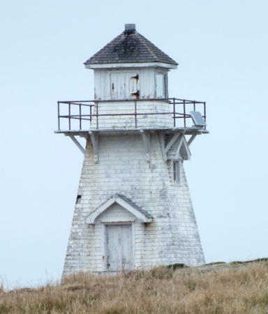
1956 (station established privately sometime before 1920). Inactive since 2010. 5.5 m (18 ft) square pyramidal wood tower with lantern and gallery, painted white; the lantern formerly had a red roof. Fog whistle (blast every 20 s). Marie-Laure Even contributed a 2011 photo, Robert Smith has a 2009 closeup and a 2008 photo, and Google has a distant satellite view. The abandoned lighthouse is probably endangered; it appears in rather poor condition in Andreas Köhler's 2019 photo at right. Descendents of the MacDonald family, who claim ownership of the island, are interested in acquiring the lighthouse as well. Located on a small island about 90 meters off the north coast of the Strait of Belle Isle. Accessible only by boat, but easily visible from land near the village of West St. Modeste. Site open, tower closed. Site manager: Canadian Coast Guard. ARLHS CAN-700; ex-CCG N-229; ex-Admiralty H0111; ex-NGA 1004.
**** Point Amour
1858 (François Baby). Active; focal plane 46 m (152 ft); white light, 16 s on, 4 s off. 33 m (109 ft) round tower with lantern and gallery, attached to a 2-story keeper's house. The tower is limestone covered with brick and then with clapboards. 2nd order Fresnel lens in use. Lighthouse painted white with a single black band; lantern roof is red. Fog horn (blast every 30 s). Two modern dwellings and other buildings; one of the houses is available for overnight accommodations. Fog signal building (1906). Corinne Gaudet's 2022 photo is at the top of this page, Anderson has a fine page for the lighthouse, the Labrador Coastal Drive tourist web site also has a page for the lighthouse, Mimi Godin has a 2021 photo, Huelse has a historic postcard view, and Google has a satellite view of the station. This historic lighthouse marks the narrowest point of the Strait of Belle Isle; the strait here is about 15 km (9 mi) wide. One of four stone towers built on the northern approaches to the St. Lawrence in the 1850s, it is still the second tallest lighthouse in Canada. The Labrador Straits Historical Development Corporation manages the light station, operating a museum in one of the buildings; the original lamp is on display. In December 2013 the lighthouse was declared a heritage property and it was announced that ownership of the station would be transferred to the provincial government; the transfer occurred shortly thereafter. The lighthouse was granted official Heritage status in 2015. Located off NF 510 at L'Anse Amour on the north shore of the Strait of Belle Isle east of Blanc Sablon at the Quebec border. Site open; tower open daily late May through mid October. Owner: Province of Newfoundland and Labrador. Site manager: Labrador Straits Historical Development Corporation . ARLHS CAN-665; CCG N-227; Admiralty H0114; NGA 1012.

St. Modeste Island Light, West St. Modeste, March 2019
Google Maps photo by Andreas Köhler; used by permission

Information available on lost lighthouses:

  • Cape Harrigan (1913-?), Nunaksaluk Island, northern coast. The light is now on a small fiberglass tower. CCG N-323; Admiralty H0064; NGA 0828.
  • Cape North (1909-?), Table Bay, southeastern coast. The light is now on a small skeletal tower. CCG N-284; Admiralty H0080; NGA 0916.
  • Copper Island (1926-?), southeast coast, near Battle Harbour. The light is now on a small fiberglass tower; Google has a distant satellite view. CCG N-277; Admiralty H0090; NGA 0972.
  • Cut Throat Island (1909-?), north side of the entrance to Hamilton Inlet. The light is now on a small skeletal tower. CCG N-318; Admiralty H0074; NGA 0856.
  • Domino Point (1913-?), Island of Ponds, southeastern coast. The light is now on a small skeletal tower. CCG N-281; Admiralty H0084; NGA 0928.
  • Drawbucket Tickle (?-?), Cairn Island, near Davis Inlet, north central coast. The light is on a small skeletal tower. CCG N-324; Admiralty H0062; NGA 0824.
  • Ford's Harbour (1913-?), east end of Paul Island, north central coast. The light is on a small skeletal tower. CCG N-325; Admiralty H0060; NGA 0820.
  • Henley Harbour (Château Point) (1929-?), south end of Castle Island, marking the entrance to Henley Harbour. The light is on a small skeletal tower; Google has a distant satellite view. CCG N-270; Admiralty H0108; NGA 0980.
  • Manuel Island (Napakataktalik) (1913-?), north central coast. The light is now on a small fiberglass tower. CCG N-322; Admiralty H0068; NGA 0832.
  • Pack's Harbour (1909-?), southeast coast. The light is now on a small fiberglass tower. CCG N-285; ARLHS CAN-1356; Admiralty H0078; NGA 0912.
  • Red Island (1928-?), Hawke Bay. The light is now on a small skeletal tower. CCG N-280; ARLHS CAN-1357; Admiralty H0086; NGA 0936.
  • Sandy Point Island (1920s?-1940s?), north central coast. ARLHS CAN-1358.
  • Sloop Harbour Point (1928-?), central coast. The light is now on a small skeletal tower. CCG N-319; ARLHS CAN-1359; Admiralty H0072; NGA 0852.
  • White Point (Indian Tickle) (1905-?), Indian Tickle near Cartwright. The light is now on a small skeletal tower. CCG N-282; ARLHS CAN-1360; Admiralty H0082; NGA 0924.
  • Winsor Harbour Island (Tikkerasuk Island) (1913-?), north central coast near Hopedale. The light is now on a small fiberglass tower. CCG N-321; ARLHS CAN-1361; Admiralty H0070; NGA 0848.

Notable faux lighthouses:


Camp Islands Light, Battle Harbour
Canadian Coast Guard photo

Adjoining pages: North: Nunavut and Northern Québec | South: Northern Newfoundland | West: Northeastern Québec

Return to the Lighthouse Directory index | Ratings key

Posted June 22, 2008. Checked and revised June 26, 2024. Lighthouses: 11. Site copyright 2024 Russ Rowlett and the University of North Carolina at Chapel Hill.