Lighthouses of New Zealand: Northern North Island

New Zealand is an independent island nation in the southwestern corner of the Pacific Ocean. Its location is remote, roughly 2000 km (1200 mi) southeast of Australia and 1000 km (600 mi) south of New Caledonia and Fiji. Settled in the 13th Century by a Polynesian people known as the Māori, it was colonized by Great Britain in 1840. It has been part of the British Empire and then the British Commonwealth ever since. It is a Commonwealth realm, recognizing the British monarch as head of state. New Zealand has a population of about 5.1 million.

New Zealand is larger than many Northern Hemisphere residents might suppose: roughly 1600 km (1000 miles) long from north to south, stretching from the subtropical north to the cool temperate south. It includes two large islands, North Island and South Island, with many smaller islands. For local government the country is divided into sixteen regions, including eleven regional council areas and five unitary council areas. The regional council areas are subdivided into districts. This page describes lighthouses of the northern half of North Island (Te Ika-a-Māui) and nearby smaller islands, including the Northland, Auckland, Waikato, Bay of Plenty, and Gisborne Regions.

Most of the coastline of New Zealand is high and scenic. Many of the lighthouses are at remote locations and lighthouse fans need a good pair of hiking shoes to reach some of them, if they can be reached at all.

Coastal lighthouses are operated and maintained by Maritime New Zealand (MNZ). Information on most of these lighthouses is readily available on the MNZ web site. Harbor lighthouses, however, are owned and maintained by local harbor authorities and less information is available for most of them. There is no national lighthouse preservation group but Heritage New Zealand has acted to preserve several lighthouses after they were deactivated.

Many of the place names in New Zealand are in the Māori language. The Māori phrase for a lighthouse is whare rama or whare tūrama; motu is an island, toka is a rock, and whanga is a harbor.

ARLHS numbers are from the ARLHS World List of Lights. Admiralty numbers are from Volume K of the Admiralty List of Lights & Fog Signals. U.S. NGA light list numbers are from NGA Publication 111.

General Sources
Maritime New Zealand - Lighthouses of New Zealand
Information available on Maritime New Zealand's lighthouse site.
List of Lights
Official light lists posted by Land Information New Zealand.
Online List of Lights - New Zealand
Photos by various photographers posted by Alexander Trabas. Many of the photos for North Island are by Michael Boucher.
Encyclopedia of New Zealand - Lighthouses
A historical account by Helen Beaglehole.
List of Lighthouses in New Zealand
Index to Wikipedia articles.
Leuchttürme.net - Neuseeland
Photos and data posted by Malte Werning.
New Zealand Lighthouses
Data and photos posted by Kevin Mulcahy of Lighthouses.net.au.
World of Lighthouses - New Zealand
Photos by various photographers available from Lightphotos.net.
Lighthouses in New Zealand
Photos by various photographers available from Wikimedia Commons.
New Zealand Lighthouses
Photos taken in 2017 by Larry Myhre.
Leuchttürme Australiens, Neuseelands und Ozeaniens auf historischen Postkarten
Historic postcard views posted by Klaus Huelse.
GPSNavigationCharts
Navigation chart information for New Zealand.
Navionics Charts
Navigation chart for New Zealand.
 

Kaipara North Head Light
Kaipara North Head Light, Pouto, March 2013
Flickr photo copyright Bill Dutfield; used by permission


Bean Rock Light, Auckland, January 2021
Google Maps photo by Julia MacArthur

Waikato Region West Coast Lighthouses

Waitomo District Lighthouse
Taharoa Ironsands
Date unknown. Active; focal plane 36 m (118 ft); white light, 2 s on, 4 s off, 2 s on, 12 s off. 12 m (39 ft) tower, painted with red and white horizontal bands, rising from a 1-story building. No photo available but Google has a distant satellite view. Located at the headquarters of the Taharoa Ironsands mine. Site and tower closed. Owner/site manager: New Zealand Steel. Admiralty K4096; NGA 4836.

Ōtorohanga District Lighthouse
Kawhia Harbour
Date unknown. Active; focal plane 11 m (36 ft); white light, 2 s on, 2 s off. 11 m (36 ft) tower, painted with yellow and white horizontal bands, mounted on a platform. No photo available but Google has a distant satellite view. Located in Kawhia Harbour, a sheltered harbor about 25 km (15 mi) south of Raglan Harbour. Accessible only by boat. Site open, tower closed. Admiralty K4101.1.

Waikato District: Raglan Lighthouses
Raglan Harbour (Putoetoe Point) Range Middle
Date unknown. Active; focal plane 13 m (43 ft); continuous red light. Approx. 8 m (26 ft) wood skeletal tower painted white and carrying a large triangular daymark, point up, painted orange with a white border. Google has a street view and an indistinct satellite view. Raglan is a town of about 3800 residents on the central west coast of North Island. Its harbor, called Whaingaroa Harbour, it is one few good harbors along this section of coast. The front light of the range is on a large triangular daymark panel on Putoetoe Point about 400 m (1/4 mi) west of the middle light. Located above the waterside trail off Wi Neera Street in Raglan. Site status unknown (the light is surrounded by heavy vegetation) but there's a good view from a nearby pedestrian bridge. Admiralty K4104.1; NGA 4848.
* Raglan Harbour (Putoetoe Point) Range Rear
Date unknown. Active; focal plane 26 m (85 ft); continuous light, white, red or green depending on direction. 8 m (26 ft) tripod carrying a very large diamond-shaped daymark panel painted orange with a white border, standing on a 1-story square wood equipment shelter; the light is mounted on the equipment shelter. Building painted black. Google has a street view but the light is hard to spot in Google's satellite view. Located on a hillside on Long Street in Raglan. Site open, tower closed. Admiralty K4104.2; NGA 4852.

Auckland Region West Coast Lighthouses

Manukau Harbour Lighthouses
Manukau Harbour is a sheltered bay about 20 km (13 mi) in diameter located on the southwest side of Auckland. It is connected to the Tasman Sea (on the west coast of the island) by a strait only 1800 m (1.12 mi) wide.

Manukau South Head (1) replica (Awhitu, Manukau Heads)
2006 replica of 1874 lighthouse. A decorative white light is displayed; focal plane 117 m (385 ft). 9 m (30 ft) octagonal wood tower with lantern and gallery. Lighthouse painted white, lantern black. The original cast iron lantern and 2nd order Fresnel lens, stored since 1986, have been reinstalled on the replica tower. Lee Gilbert's photo is at right, Phil Armitage has a good photo, another fine photo is available, Sandy Austin has a closeup, Lukas Falke has a street view, and Google has a satellite view. The Manukau Heads Lighthouse Trust was formed in 2000 to organize the reconstruction, which involved nearly everyone in the Manukau community in some way. The rebuilt lighthouse was dedicated by New Zealand Prime Minister Helen Clark on 23 September 2006 and a decorative light was established on 7 June 2008. Unfortunately the road to the lighthouse was closed by a major landslide during Cyclone Gabrielle in February 2023. The estimate is that access will not be restored until at least October 2024. Located at the end of Manukau Heads Road near the signal station. Accessible by road; parking available. Site and tower closed in 2024. Site manager: Manukau Heads Lighthouse Trust . ARLHS NZL-033M.
Manukau South Head (3)
1989 (station established 1874). Active; focal plane 234 m (768 ft); white light, 4 s on, 2 s off. Light mounted on a mast rising from a 1-story signal station building. Derek Collier has a photo of the mast and Google has a satellite view. The original lighthouse at this station was a 9 m (30 ft) wooden tower with a large lantern. It collapsed in 1944 when nearby coast artillery were test fired. The second light, a short concrete tower, came into imminent peril of collapse due to beach erosion; it was deactivated in 1986 and demolished early in the 1990s. Grant Maizels found rubble on the beach in 1998. The light was moved to the signal station high on the bluff above. Located at the south entrance to Manukau Harbour, southwest of Auckland. Site open, tower open daily. Operator/site manager: Ports of Auckland. ARLHS NZL-033; Admiralty K4108; NGA 4868.
Ninepin Rock (2?)
Date unknown. Active; focal plane 29 m (95 ft); four white flashes every 30 s. MNZ lists a 1 m (3 ft) pedestal but Victor Rull's photo shows a 5 m (17 ft) white concrete tower. Kelvin Reid also has a photo and Google has a satellite view. A panoramic street view shows the wonderful scenery of this area. Located atop a massive rock on the north side of the entrance to Manukau Harbour. Site and tower closed. Operator/site manager: Ports of Auckland. Admiralty K4107; NGA 4856.

Manukau South Head Light replica, Auckland, March 2014
Flickr Creative Commons photo by Lee Gilbert

Northern West Coast Lighthouses
* Piha
Date unknown. Active; focal plane 266 m (873 ft); white flash every 15 s. 5 m (17 ft) semielliptical white concrete tower. A 2018 photo is available and Google has a street view and a satellite view. This tower is said to be at a former Royal New Zealand Air Force searchlight station. Located atop a spectacular cliff at the end of Log Race Road, above the Piha beaches, about 12 km (7.5 mi) north of Manukau North Head. Site open, tower closed. Operator/site manager: Maritime New Zealand. ARLHS NZL-091; Admiralty K4122; NGA 4884.
Kaipara South Head
Date unknown. Active; focal plane 41 m (135 ft); white flash every 7.5 s. 4 m (13 ft) round white tower. No photo available but Google has a satellite view. Kaipara Harbour is a large estuary opening on the west side of the North Island north of Auckland. Located on the south side of the exit from Kaipara Harbour. Site status unknown (probably on private property). Operator: Kaipara Harbour Management. Admiralty K4132; NGA 4888.

Northland Region Lighthouses

Kaipara District Lighthouses
Kaipara North Head (Pouto)
1884. Inactive 1940-1947 and since 1956. 14 m (46 ft) hexagonal wood tower with lantern and gallery, painted white; lantern roof is red. Bill Dutfield's photo is at right, Kazuya Takahashi has a 2022 photo, Evan Kennedy has a 2017 photo, a 2012 closeup is available, Mulcahy's page has the history of the lighthiuse, and Google has a satellite view. This is a sibling of the Waipapa Point Light on South Island, which was completed the same year. These two lighthouses, designed by John Blackett, were the last two wood lighthouses built in New Zealand in the 1800s. The original lantern was removed in 1944 and relocated to Cape Saunders in 1948 (see the South Island page). The present lantern was relocated from Cape Foulwind in 1947. By 1971 the Marine Department was preparing to demolish the abandoned lighthouse. Area residents formed the Kaipara Lighthouse Trust to work for its preservation. In 1979 the property was conveyed to the New Zealand Historic Places Trust (now Heritage New Zealand). The Trust carried out a restoration of the lighthouse in 1982-84, just in time for the centennial of the light. The lighthouse was repainted and refurbished again in 2008. Located on the north side of the Kaipara Harbour entrance west of Pouto. Accessible by 4WD vehicles or by a hike of about 6 km (4 mi) on the beach. Site open, tower may be open on occasion (inquire locally). Owner/site manager: Heritage New Zealand. ARLHS NZL-030.
* Pouto Point (1) (relocated to Dargaville)
Date unknown. Inactive. 4 m (13 ft) octagonal wood lantern room, painted white with a red roof. Tania Phelan's photo is at right, Bill Dutfield has a 2013 closeup photo, Steve Withers has a distant street view, and the tiny lighthouse is centered in Google's satellite view. This light was formerly at the village of Pouto Point, a short distance northeast of Kaipara North Head; it was replaced there by a light on a square fiberglass cabinet (focal plane 5 m (18 ft); white flash every 5 s) seen in a Google street view. We need information on the history of this light beacon. The historic lighthouse stands now beside the entrance road to the Dargaville Museum on the south side of Dargaville. Site open, tower closed. Owner/site manager: Dargaville Museum. Modern light (Operator: Kaipara Harbour Management): Admiralty K4130; NGA 4904.
Sail Point
Date unknown. Active; focal plane 10 m (33 ft); white flash every 10 s. 3 m (10 ft) round cylindrical white fiberglass tower. No photo available but Bing has a satellite view. Located on the toe of a headland on the west side of upper Kaipara Harbour. Site status unknown. Operator: Kaipara Harbour Management. Admiralty K4140; NGA 4900.

Pouto Point Light, Pouto, July 2017
Google Maps photo by Tania Phelan

Far North District Lighthouses
Reef Point (Tauroa Point)
Date unknown. Active; focal plane 65 m (213 ft); two white flashes every 10 s. 3 m (10 ft) round cylindrical white fiberglass tower. A commercial photo is available and Google has a satellite view. The surrounding area is preserved as the Ahihara Gumfields Historic Reserve, where kauri gum (used in the production of varnish) was harvested during the late 19th and early 20th centuries. Located on an isolated headland west of Ahihara and about 100 km (60 mi) south southeast of Cape Reinga. Site open but not easy to reach, tower closed. Operator: Maritime New Zealand. ARLHS NZL-050; Admiralty K4153; NGA 4912.
Three Kings (Great Island, Manawatāwhi)
1969. Inactive. 5 m (17 ft) octagonal white concrete tower. No photo available but Bing has a distant satellite view. NZGeo.com has an article that mentions the lighthouse. The Three Kings Islands are a group of 13 rugged and uninhabited islands about 55 km (34 mi) northwest of Cape Reinga. The islands are a nature reserve. They are not part of the Northland Region but are administered by the central government as an Area Outside Territorial Authority. Located on the north edge of Great Island, the largest of the group. Accessible only by boat. Site and tower closed.
Cape Maria van Dieman (1) (Motuopao)
1879. Inactive since 1941. This was an octagonal wood tower with lantern and gallery; only the wood base remains. The Department of Conservation has the photo at right, Roger Boner has a very distant view, Peter Waworis has a similar view, and Google has a satellite view. The Department has placed a cap over the tower to protect it. Cape Maria van Diemen, facing the Tasman Sea, is the westernmost of the three points of land at the northern end of New Zealand, the other two being Cape Reinga and North Cape. Because of the difficulty in accessing and supplying the light station, the lighthouse was deactivated in 1941 and its lantern and lens transferred to a new tower at Cape Reinga (see below). Located on the summit of Motuopao Island off the point of the cape. Accessible only by boat. The island is a nature reserve closed to the public; the lighthouse is distantly visible from beaches on the mainland. Site and tower closed. Owner/site manager: N.Z. Department of Conservation (Motuopao Island Nature Reserve). ARLHS NZL-010.
Cape Maria van Diemen (2)
1941 (station established 1879). Active; focal plane 90 m (295 ft); three white flashes every 20 s. 3 m (10 ft) round cylindrical fiberglass tower; no lantern. Adam Penberthy has a 2017 photo, Peter Waworis has a 2013 photo, and Google has a satellite view. Located on the mainland point of the cape. Site open, tower closed. Operator/site manager: Maritime New Zealand. Admiralty K3686; NGA 3792.

1879 Cape Maria van Dieman Light, Motuopao Island
N.Z. Departmant of Conservation photo
* Cape Reinga
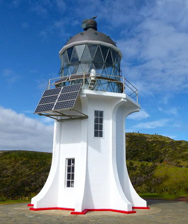
1941. Active; focal plane 165 m (542 ft); white flash every 12 s. 10 m (33 ft) octagonal concrete tower with lantern and eight ribs. Tower painted white; lantern roof is black. Bernard Spragg's photo is at right, Trabas has Boucher's closeup, Daniel Goertz has a 2022 photo, Rian Long has a good panoramic view, Wikipedia has an article with a photo by James Shook, Wikimedia has additional photos, Vasily Martynov has a street view, and Google has a satellite view. This light on Cape Reinga replaced the 1879 Cape Maria van Diemen lighthouse as the main landfall light at the northern extremity of New Zealand. It carries the original Maria van Diemen lantern, but the 1st order Fresnel lens has been replaced by a small modern lens. It stands on a spectacular site overlooking the Pacific to the northeast and the Tasman Sea to the northwest. The surrounding area is included in the Te Paki Recreation Reserve. Accessible by road from Kaitaia, and in 2010 the last 20 km (13 mi) of the road were paved. There's a walk of about 300 m (330 yd) round trip from the parking area to the lighthouse. Site open, tower closed. Operator/site manager: Maritime New Zealand. . ARLHS NZL-012; Admiralty K3688; NGA 3796.
* North Cape (Murimotu Island) (1) (lantern)
1929. Inactive since 1973. Round cast iron lantern. Originally located on Murimotu Island off North Cape, the northernmost point in New Zealand. The lighthouse was demolished in 1973 but the lantern stands beside Highway 1 at Waitiki Landing, about 25 km (15 mi) southwest of Cape Reinga. The Fresnel lens, formerly displayed with the lantern, has been stolen, and the lantern is also missing its ventilator ball. Google has a street view but a tree hides the lantern in Google's satellite view. Site open. Owner/site manager: Waitiki Tourist Complex. Original lighthouse: ARLHS NZL-066.
North Cape (Murimotu Island) (2)
1973 (station established 1929). Active; focal plane 99 m (325 ft); white flash every 8 s. 4 m (13 ft) round cylindrical white concrete tower. Trabas has Jim Smith's view, the small light is barely visible in an aerial photo of the island, and Google has a satellite view. No photos of the original lighthouse have been found. Located at the highest point of Murimotu Island, just off North Cape. The island is part of the North Cape Scientific Reserve and access is restricted. Site and tower closed. Operator: Maritime New Zealand. Admiralty K3690; NGA 3800.
Parengarenga Harbour (2)
Date unknown. Active; focal plane 47 m (154 ft); two white flashes every 5 s. 5 m (17 ft) sqaure white tower. No photo available but Bing has a distant satellite view. Parengarenga Harbour is an estuarine inlet about 13 km (8 mi) south of North Cape. Located on heights on the north side of the inlet. Site status unknown. Admiralty K3690.4; NGA 3804.

Cape Reinga Light, Cape Reinga, August 2015
Wikimedia Creative Commons photo by Bernard Spragg
[Cape Karikari]
Date unknown. Active; focal plane 59 m (194 ft); three white flashes every 15 s. 3 m (10 ft) round white concrete tower. No photo available but Google has a satellite view. There appears to be a small equipment shelter next to the light. Located on a prominent cape at the tip of the Karikari Peninsula about 80 km (50 mi) southeast of North Cape. There is a track to the lighthouse but it may pass through private property. Site status unknown. Operator: Maritime New Zealand. Admiralty K3694; NGA 3812.
Nukutaunga Island (Cavalli Islands)
Date unknown. Active; focal plane 111 m (363 ft); white flash every 10 s. 4 m (13 ft) round metal tower painted white. No photo available but Google has a satellite view. The Cavalli Islands are a group of high islands off Whangaroa. Located atop the island of Nukutaunga. Site status unknown. Operator: Maritime New Zealand. ARLHS NZL-076; Admiralty K3699; NGA 3824.
Veronica Channel Range Front
Date unknown. Active; focal plane 30 m (98 ft); quick-flashing white light. 18 m (59 ft) square cylindrical skeletal tower painted white. No photo available but Google has an indistinct satellite view. The range guides vessels in the Bay of Islands, a complex inlet popular as a resort area. The rear light is on a 6 m (20 ft) pole. Located on Veronica Point on the west side of the bay. Site status unknown. Admiralty K3705.1; NGA 3862.
Fraser Rock
Date unknown. Active; focal plane 13 m (43 ft); flash every 4 s, white or red depending on direction. MNZ lists a "metal tower," but Trabas has Boucher's photo showing what appears to be a 4 m (13 ft) square concrete tower. Bing has a satellite view. Located on a reef off Tapeka Point, a peninsula projecting into the south side of the Bay of Islands. Accessible only by boat. Site open, tower closed. Admiralty K3700; NGA 3832.
Cape Brett (1)
1910. Inactive since 1978. 14 m (46 ft) round cast iron tower with lantern, painted white. The 1-story wood keeper's house (one of three in the original light station) now shelters hikers. By 2005 the lighthouse was in critical need of restoration. In 2007 the Department of Conservation scraped 60 layers of paint from the lighthouse and restored the exterior to its original appearance; a good October 2007 photo shows the results. Michael Boucher's photo is seen at right, Grant Maizels also has a page on this light, Lightphotos.net has Jan de Jonge's photo, Jerry Liu has a beautiful 2018 photo, and Google has a satellite view. Trabas has Darlene Chisholm's photo of the active light (focal plane 146 m (479 ft); white flash every 15 s) on a 4 m (13 ft) cylindrical fiberglass tower standing in front of the historic lighthouse. In August 2009 the light station was registered as a Category I Historic Place. The Cape Brett area is now a national scenic reserve. Located at the end of a rugged peninsula on the south side of the Bay of Islands. Accessible by water taxi or by backpacking about 20 km (13 mi) from Rawhiti-Whangamumu Road. Site open, tower closed (may be open for tours; inquire locally). Operator: Maritime New Zealand. Owner/site manager: N.Z. Department of Conservation (Manawahuna Scenic Reserve). . ARLHS NZL-005. Active light (Operator: Maritime New Zealand): Admiralty K3709; NGA 3912.

Cape Brett Light, Manwahuna Reserve
photo copyright Michael Boucher; used by permission

Whangarai District Lighthouses
[Poor Knights Islands]
Date unknown. Active; focal plane 158 m (518 ft); white flash every 5 s. 4 m (13 ft) rectangular metal cabinet. Mulcahy has a photo and Bing has a satellite view. The Poor Knights Islands are isolated islands about 50 km (30 mi) northeast of Whangerai. Located atop the northernmost island of the group. Site and tower closed (nature reserve). Operator: Maritime New Zealand. ARLHS NZL-084; Admiralty K3711; NGA 3920.
Tutukaka Head (South Gable) (1)
1940. Inactive. 4 m (13 ft) square pyramidal concrete tower painted white; the tower is topped by a mast carrying wind measuring instruments. The active light (focal plane 92 m (302 ft); white flash every 10 s) is on a small square metal cabinet. Mulcahy has a photo, a 2021 photo and another photo are available, Trabas has Eckhard Meyer's photo, and Google has a fuzzy satellite view. Located on Kukutauwhao Island on the north side of the entrance to Tutukaka harbor northeast of Whangarai. The island is connected tenuously to the mainland by a sandbar, making the lighthouse accessible by a hiking trail. Site open, tower closed. Operator: Maritime New Zealand. ARLHS NZL-072(=088). Active light: ARLHS NZL-072; Admiralty K3712; NGA 3924.
[Bream Head]
Date unknown. Active; focal plane 172 m (563 ft); three white flashes every 20 s. 4 m (13 ft) rectangular metal cabinet. Talman Madsen has a distantphoto (light is at lower right), Sarjio Chadha has a distant drone view, and Bing has a satellite view. Located on a prominent headland at the north entrance to Bream Bay. Accessible by a strenuous hiking trail. Site open, tower closed. Operator: Maritime New Zealand. Admiralty K3713; NGA 3932.
Coppermine (Marotiri) Island
Date unknown. Active; focal plane 145 m (476 ft); white flash every 5 s. 3 m (13 ft) round cylindrical white metal tower. Mulcahy has a photo and Bing has a satellite view. Located at the east end of an island about 15 km (9 mi) east of Bream Head. Accessible only by boat. Site status unknown. Operator: Maritime New Zealand. Admiralty K3714; NGA 3976.
Marsden Point (Leading)
Date unknown. Active; focal plane 22 m (72 ft); continuous light, white, red or green depending on direction. 20 m (66 ft) skeletal mast. A distant aerial view is available (zoom in, tower is left of center at the water's edge) and Google has a satellite view. The light guides tankers to a large oil terminal in Whangerai Bay. Located on the point about 10 km (6 mi) west of Bream Head. Site and tower closed. Admiralty K3716; NGA 3933.
Mokohinau Islands (Burgess Island)
1883. Active; focal plane 122 m (400 ft); white flash every 10 s. 14 m (46 ft) round cylindrical stone tower with lantern and gallery. Lighthouse painted white, gallery black. Other light station buildings demolished. A 2020 photo is at right, Dave Saggs has a photo, and Google has a satellite view of the station. Wikimedia's article has a historic photo. The lighthouse is the landfall light for vessels arriving in Auckland from the north or northeast. Located on Burgess (Pokohinu) Island, the highest of the three Mokohinau Islands in the entrance to Hauraki Gulf about 100 km (60 mi) north of Auckland. Burgess is the only one of the islands open to the public. Accessible only by boat; the island is sometimes visited by ecotours from Auckland. Site open, tower closed. Operator: Maritime New Zealand. Site manager: N.Z. Department of Conservation (Mokohinau Islands Scenic and Nature Reserves). . ARLHS NZL-035; Admiralty K3734; NGA 3984.

Mokohinau Islands Light, Hauraki Gulf, December 2020
Instagram photo by ardeafish

Auckland Region East Coast Lighthouses

Northwestern Hauraki Gulf Lighthouses
Hauraki Gulf (Tīkapa Moana) is a protected, island-strewn bay opening to the Pacific Ocean north of Auckland. The gulf is about 100 km (60 mi) long and as much as 50 km (30 mi) wide.
[Cape Rodney]
1967. Active; focal plane 53 m (174 ft); four quick white flashes every 20 s. 4 m (13 ft) square cylindrical steel tower topped by a short mast. Google has a satellite view. In 2019 the land surrounding and including the lighthouse was for sale. Located on the cape, on the western shore of Hauraki Gulf near Leigh. Operator: Maritime New Zealand. Site and tower closed. Site manager: private. ARLHS NZL-013; Admiralty K3736.6; NGA 3992.
[Kawati Point]
Dare unknown. Active; focal plane 34 m (112 ft); white or red light, depending on direction, 3 s on, 3 s off. 4 m (13 ft) square cylindrical steel tower topped by a short mast. Mulcahy has a photo and Google has a distant satellite view. Located on the north point of Kawau Island, on the west side of Hauraki Gulf near Omaha. Accessible only by boat. Operator: Maritime New Zealand. Site and tower closed. Site manager: private. ARLHS NZL-081; Admiralty K3738.2; NGA 4008.
Flat Rock (Kawau Island) (5?)
1922 (station established 1867). Active; focal plane 13 m (43 ft); white flash every 7 s. 8 m (26 ft) round white fiberglass tower mounted on a round concrete pier. Pier also painted white. A photo is available and Bing has a satellite view.The first three beacons on this reef were washed away by storms. Located on a skerry off the east coast of Kawau Island. Accessible only by boat. Operator: Maritime New Zealand. Site open, tower closed. ARLHS NZL-023; Admiralty K3738; NGA 4020.
* Tiritiri Matangi (Tiritiri Island)
1865 (McLean, Simpson and Co.). Active; focal plane 91 m (300 ft); white flash every 15 s. 20 m (67 ft) round cast iron tower with lantern and gallery. Lighthouse painted white. Two 1-story keeper's quarters (1918), one used as a visitor center and the other as a park ranger residence. 1-story concrete fog signal building (1935); original diaphone fog signal in place but not used since about 1983. Auckland Harbour Board signal station (1912). Rubie Ji's photo is at right, Sandy Austin has a photo, another good photo is available, Trabas has Tom Chisholm's photo, and Google has a street view and a satellite view. The lighthouse was prefabricated in Pimlico, England, and is a twin of the Cape Egmont Light. This is New Zealand's oldest active lighthouse and the most complete light station in the country. The Supporters of Tiritiri Matangi work for the ecological restoration of the island and the preservation of the historic buildings. Native trees, birds, and other wildlife have been successfully reintroduced to the island. Located near the southeastern end of Tiritiri Island in Hauraki Gulf about 30 km (19 mi) north of Auckland. Accessible only by boat; the island is accessible by passenger ferry from Gulf Harbour and downtown Auckland (visitation is limited to 150 passengers per day). Guided tours of the island are available. Site open, tower closed. Operator: Maritime New Zealand. Site manager: N.Z. Department of Conservation (Tiritiri Matangi Scientific Reserve). . ARLHS NZL-054; Admiralty K3740; NGA 4028.

Tiritiri Matangi Light, Auckland, September 2019
Instagram photo by Rubie Ji

Auckland Harbour Lighthouses
Rangitoto Island
1905. Active; focal plane 21 m (69 ft); red light, 1.5 s on, 10.5 s off. 20 m (65 ft) round tapered concrete tower with gallery, painted white with narrow red horizontal bands. The lighthouse never had a lantern. Stefan Marks's photo is at right, Trabas has Darlene Chisholm's photo, Debra Markey has a fine 2008 closeup, a 2022 photo is available, and Google has a satellite view. The lighthouse was built in the 1880s but due to some bureaucratic bickering it was not activated until 1905. Rangitoto Island is a volcanic island (last active around 1450), one of several large islands in Auckland Harbour. It is protected as the Rangitoto Island Scenic Reserve and is accessible by passenger ferry from downtown Auckland. 4WD tours of the island often pass close to the lighthouse. The lighthouse is located on a small islet just off the western end of Rangitoto Island. Accessible only by boat. Site and tower closed. Operator/site manager: Ports of Auckland. . ARLHS NZL-045; Admiralty K3744; NGA 4048.
St. Leonard's Approach (Leading)
Date unknown. Active; focal plane 23 m (75 ft); continuous light, white, red or green depending on direction. Approx. 8 m (26 ft) "metal column," according to MNZ. Trabas has Boucher's view from the sea showing something more substantial than a post light. Vegetation hides the light in Google's satellite view. This is the approaching light leading vessels from the open Hauraki Gulf into Auckland. Located on a very steep bluff in the St. Leonard's Beach neighborhood north of Auckland. Site and tower closed. Operator/site manager: Ports of Auckland. Admiralty K3745; NGA 4052.
Bean Rock
1871. Active; focal plane 15 m (50 ft); three white flashes every 8 s. 15 m (50 ft) hexagonal cast iron skeletal tower supporting a hexagonal wood keeper's quarters with lantern centered on the roof. Entire structure painted white. Fog siren (blast every 30 s). Julia MacArthur has the 2021 photo seen at the top of this page, Paul Salmon has a 2018 photo, Trabas has Boucher's photo, Jeremy D'Entremont has written a feature article on the lighthouse for the February 2002 Lighthouse Digest, Werning has a page for the lighthouse, and Google has a satellite view. This unique lighthouse has been a landmark in Auckland Harbour ever since its construction; its 150th anniversary was celebrated in 2021. In 1985 the cottage was lifted to shore by helicopter and restored while the rotten legs of the structure were replaced with new hardwood on concrete pilings. Located on Te Toka a Kapetawa (the Rock of Kapetawa) off North Head at the entrance to Auckland's inner harbor. Accessible only by boat. Site and tower closed. Operator/site manager: Ports of Auckland. . ARLHS NZL-003; Admiralty K3748; NGA 4064.

Rangitoto Island Light, Auckland, September 2019
Flickr Creative Commons photo by Stefan Marks

Southern Hauraki Gulf Lighthouses
Maria (Ruapuke) Island
Date unknown. Active; focal plane 35 m (115 ft); three flashes every 15 s, white or red depending on direction. 4 m (13 ft) white concrete tower. Trabas has Boucher's distant view from the sea, Victor Chen has a very distant view, and Google has a satellite view. The photo suggests the tower may be taller than listed. Located atop one of The Noises, a group of small, uninhabited islands in the southern Hauraki Gulf. Accessible only by boat. Site and tower closed (the island is privately owned). Operator: Maritime New Zealand. Admiralty K3742; NGA 4036.
[Ponui Passage (Sandspit Passage) (3)]
1984(?) (station established 1871). Active; focal plane 6 m (20 ft); flash every 2 s, white or red depending on direction. 6 m (20 ft) post, painted white, mounted on remains of the hexagonal screwpile platform of the original lighthouse. No photo available but Google has a satellite view of the platform. The platform originally carried a hexagonal light tower centered on a wood keeper's cottage. The cottage was removed and relocated to Ponui Island in 1938; we do not know if it survives. The light tower was returned to the platform, where it served until 1984; a 1973 photo (halfway down the page) is available and Wikipedia has a portion of the same photo. The lantern is said to be on loan to the Dockside Restaurant in Wellington, but it does not appear in available photos of that restaurant. Located at the end of a submerged sandspit at the eastern entrance to a passage south of Ponui Island in the southeastern part of Hauraki Gulf, also known as the Firth of Thames. Accessible only by boat. Site open, tower closed. Operator: Maritime New Zealand. ARLHS NZL-041; Admiralty K3852; NGA 4224.

Waikato Region East Coast Lighthouses

Thames-Coromandel District (Coromandel Peninsula) Lighthouses
The rugged Coromandel Peninsula extends northward for 85 km (53 mi) separating Hauraki Gulf from the Pacific Ocean. The peninsula is as much as 40 km (25 mi) wide.
[Cow Island]
Date unknown. Active; focal plane 33 m (108 ft); one long white flash every 8 s. 3 m (10 ft) square concrete tower. No photo available but Bing has a satellite view. NGA lists the light as Coronandel (sic) Harbor. Located on a small island off the Coromandel Peninsula on the east side of Hauraki Gulf. Accessible only by boat. Operator: Maritime New Zealand. Site status unknown. Admiralty K3878; NGA 4260.
Channel Island
Date unknown. Active; focal plane 79 m (259 ft); two white flashes every 12 s. 4 m (13 ft) white metal tower. Wang Yaozong has a distant view from the sea and Google has a satellite view. Located atop a massive rock island in the Colville Channel, the entrance to Haauraki Gulf around the northern tip of the Coromandel Peninsula. Inaccessible. Site and tower closed. Admiralty K3882; NGA 4272.
Cuvier Island (Repanga)
1889. Active; focal plane 119 m (390 ft); white flash every 15 s. 15 m (49 ft) round cast iron tower with lantern and gallery, painted white; lantern roof is black. Other light station buildings demolished. An MNZ photo is at right, Mulcahy has another MNZ photo, Glenn Matthews has a distant view from the sea, and Bing has a satellite view. The first cast iron lighthouse to be prefabricated in New Zealand, this is the landfall light for vessels arriving in Auckland from the east. The island is a nature reserve and is included in the Hauraki Gulf Marine Park. Located at the eastern tip of an island in the southern entrance to Hauraki Gulf, southeast of Great Barrier Island. Accessible only by boat; the island is closed to the public, but ecotours from Auckland sometimes provide a view from the sea. Site and tower closed. Operator: Maritime New Zealand. Site manager: N.Z. Department of Conservation (Hauraki Gulf Marine Park). ARLHS NZL-018; Admiralty K3886; NGA 4284.
[Ohinau Island]
Date unknown. Active; focal plane 105 m (344 ft); white flash every 5 s. 4 m (13 ft) white aluminum cabinet. Mulcahy has an MNZ photo and Google has a satellite view. Located on a small island off Tokarahu Point at the northeastern corner of the Coromandel Peninsula. Accessible only by boat. Site status unknown. Operator/site manager: Maritime New Zealand. ARLHS NZL-082; Admiralty K3892; NGA 4288.
Slipper Island (Whakahau)
Date unknown. Active; focal plane 103 m (338 ft); two white flashes every 15 s. 4 m (13 ft) round cylindrical lantern, painted white. Photos (halfway down the page) are available, Mulcahy has a photo, and Google has a satellite view. Slipper Island is a small, privately-owned resort island. Located on the eastern end of the island, which lies about 8 km (5 mi) southeast of Pauanui on the east coast of the Coromandel Peninsula southeast of Auckland. Accessible only by boat. Site status unknown. Operator/site manager: Maritime New Zealand. ARLHS NZL-063; Admiralty K3896; NGA 4300.

Cuvier Island Light, Hauraki Gulf
Maritime New Zealand photo

Bay of Plenty Region Lighthouses

The Bay of Plenty (Te Moana-a-Toi) is a long bight on the northeastern coast of North Island, extending about 250 km (150 mi) from the Coromandel Peninsula east of Huaraki Gulf to Cape Runaway.

Tauranga District (Tauranga Harbour) Lighthouses
Tauranga Entrance Range Front/Cutter Channel Leading
Date unknown. Active; focal plane 11 m (36 ft); continuous green light; also two continuous red, green and white directional lights, one for arriving vessels (the Entrance Range Front Light) and one for departing vessels (the Cutter Channel Leading Light). 13 m (43 ft) white skeletal tower with a vertical black stripe on the range line. Trabas has Boucher's photo, Myhre has a photo of the two range lights, Muzz Handley has a street view from Mount Mauao on the other side of the harbor entrance, and Bing has a satellite view. Tauranga is a rapidly growing port on the Bay of Plenty, now New Zealand's fifth largest city. The light as moved back 70 m (230 ft) in 2020 to escape beach erosion. Located near the beach on the west side of the harbor entrance. Site status unknown. Operator: Port of Tauranga. Admiralty K3899.4; NGA 4328.
East Limit Range Front
Date unknown. Active; focal plane 12 m (39 ft); continuous red light. 12 m (39 ft) white skeletal tower with a vertical black stripe on the range line. Trabas has Boucher's photo and Bing has a satellite view. The light marks the east limit of the entrance channel for arriving vessels. The light as moved back 70 m (230 ft) in 2020 to escape beach erosion. Located about 50 m (164 ft) northwest of the centerline light (previous entry). Site status unknown. Operator: Port of Tauranga. Admiralty K3899.5.
Tauranga Entrance Range Rear
Date unknown. Active; focal plane 17 m (56 ft); continuous green light; also a continuous leading light, white, red or green depending on direction, at a focal plane of 12 m (39 ft). 19 m (62 ft) white beacon with a vertical black stripe on the range line. Trabas has Boucher's photo, Myhre has a photo of the two range lights and Google has a satellite view. Located 252 m (275 yd) south southwest of the front light. Site status unknown. Operator: Port of Tauranga. Admiralty K3899.41; NGA 4332.
East Limit Range Rear
Date unknown. Active; focal plane 14 m (46 ft); continuous red light. 14 m (46 ft) white skeletal tower with a vertical black stripe on the range line. Trabas has Boucher's photo and Google has a satellite view. Located about 70 m (230 ft) north of the centerline light (previous entry). Site status unknown. Operator: Port of Tauranga. Admiralty K3899.51.
* [The Mount (Mauao, Mount Maunganui)]
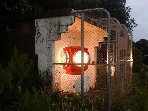
Date unknown. Active; focal plane 80 m (262 ft); white flash every 15 s. 1 m (3 ft) rotating aerobeacon protected by a concrete block wall behind and chain link fence in front. Trabas has Boucher's photo at right but the light is hard to find in Google's satellite view of the location. The Mount (Mount Maunganui) is an extinct volcanic cone 262 m (860 ft) high on the east side of the entrance to Tauranga Harbour. Located on the northern slope of the mountain. Accessible by road. Site open, tower closed. Admiralty K3899; NGA 4316.
[North Rock]
Date unknown. Active; focal plane 11 m (36 ft); flash every 3 s, white or red depending on direction. 5 m (17 ft) round solid concrete tower painted red. Trabas has Boucher's closeup photo and Google has a satellite view. Located on a reef on the east side of the entrance to Tauranga Harbour, at the foot of The Mount. Accessible only by boat. Site status unknown. Operator: Port of Tauranga. Admiralty K3899.1; NGA 4320.

Ōpōtiki District Lighthouse
Cape Runaway
Date unknown. Active; focal plane 57 m (187 ft); white flash every 5 s. 3 m (10 ft) round white fiberglass tower. Mulcahy has an MNZ photo and Google has a satellite view. Located on the cape at the eastern end of the Bay of Plenty. Site status unknown. Operator: Maritime New Zealand. ARLHS NZL-075; Admiralty K3929; NGA 4428.

The Mount Light, Tauranga
photo copyright Michael Boucher; used by permission

Gisborne Region Lighthouses

East Coast Lighthouses
[Matakaoa Point]
Date unknown. Active; focal plane 20 m (66 ft); four white flashes every 20 s. 4 m (13 ft) white square metal tower. No photo available but Google has a satellite view. Located about 30 km (19 mi) east of Cape Runaway. Site status unknown. Admiralty K3930; NGA 4432.
* East Cape
1900 (relocated to this site in 1922). Active; focal plane 154 m (505 ft); white flash every 10 s. 14 m (46 ft) round cast iron tower with lantern and gallery, painted white; lantern roof is black. Other light station buildings demolished. A 2022 photo is at right, Mike Roberts has a 2021 photo, Daniel Pietzsch has a good photo, Wikimedia has a closeup, Trabas has Boucher's closeup, Shaun Neill has a street view, Google has a very distant street view from the nearest road, and Google has a satellite view. The lighthouse marks the easternmost point of New Zealand; located only 128 km (80 mi) west of the International Date Line, it is the first lighthouse to see the sunrise of a new day. It was built originally on East Island, about 3 km (2 mi) off the cape, but it was relocated to the mainland in 1922 after earthquake-triggered landslides threatened that location. The site is spectacular. Located at the end of East Cape Road about 20 km (19 mi) east of NZ 35 at Te Araroa. Parking and a public toilet are provided, but it's a stiff climb up 800 steps to the lighthouse (bring water and sunscreen). Site open, tower closed. Operator/site manager: Maritime New Zealand. . ARLHS NZL-020; Admiralty K3932; NGA 4436.
[Gable End Foreland]
Date unknown. Active; focal plane 210 m (689 ft); white flash every 15 s. 4 m (13 ft) square metal cabinet. Mulcahy has a photo and Google has a satellite view. Located on a remote headland about 30 km (19 mi) northeast of Gisborne. Site status unknown. Operator/site manager: Maritime New Zealand. ARLHS NZL-078; Admiralty K3950; NGA 4456.
Tuaheni (Tuahine, Tuahene) Point (3)
1911 (station established 1905). Inactive since the 1950s. Approx. 24 m (79 ft) structure, including an 8 m (26 ft) octagonal cast iron tower with lantern and gallery, now in ruins, perched atop a tall concrete pillar. The iron tower is red with rust. Jordan Kappely has a photo, Mike Bartlett has a photo, and Google has a satellite view. Endangered. The first lighthouse burned soon after it was built, and its replacement (1909) was damaged by a landslide. The active light has been moved to a post atop the headland above the cape (focal plane 128 m (420 ft); white light, 2 s on, 6 s off). Tuaheni Point is a sharp cape at the end of the Mahia Peninsula. Located on a rock just off the tip of the point, about 6 km (3.5 mi) southeast of Gisborne at the south end of Wainui Beach. Site open but difficult to access; tower closed. Modern light (Operator: Maritime New Zealand): Admiralty K3954; NGA 4460.
* [Gisborne Entrance Channel Range Rear]
Date unknown. Active; focal plane about 12 m (39 ft); continuous blue light. 11 m (36 ft) post carrying a large triangular daymark colored orange with a black vertical stripe. Trabas has Boucher's photo and Google has a street view and an indistinct satellite view. The front light is on a short skeletal tower. Located on the main quay in downtown Gisborne, a city of about 40,000 residents. Site open, tower closed. Admiralty K3966.1; NGA 4480.

East Cape Light, Gisborne, August 2022
Instagram photo by the_treat_life
* Waikanae Beach Range Rear
Date unknown. Inactive since 2020. 21 m (69 ft) square cylindrical skeletal tower carrying an orange triangular daymark. The tower is in the distance in Boucher's closeup photo of the front light and Google has a street view and a satellite view. the range guides ships into Poverty Bay; The ships must then make a right-aangle turn into the Gisborner Entrance Channel. Admiralty dropped this light in 2016 when the front light was converted to a directional light. However, the New Zealand light list continued to list the rear light until 2020. Located on Awapuni Road southwest of Gisborne. Operator: Eastland Port. Site open, tower closed. ex-Admiralty K3958.1; NGA 4468.

Notable faux lighthouses:

Adjoining pages: North: Fiji | South: Southern North Island

Return to the Lighthouse Directory index | Ratings key

Posted April 2, 2004. Checked and revised December 9, 2023. Lighthouses: 45. Site copyright 2023 Russ Rowlett and the University of North Carolina at Chapel Hill.