Lighthouses of Southeastern Iran

The Islamic Republic of Iran has a long southern coastline on the Gulf of Oman and Persian Gulf and a much shorter northern coastline on the Caspian Sea. This page is for lighthouses of the southeastern coast on the Gulf of Oman and Strait of Hormuz; lighthouses of the Persian Gulf are on the Southwestern Iran page and the Northern Iran page has the lighthouses of the Caspian coast.

Notes on nomenclature: Historically Iran was called Persia in the west and the word Persian is often used in describing the country's culture and language. The language is also called Fārsī. The Persian Gulf (as it is usually known in the West) is called the Gulf of Fars (Xalij-e Fârs) in Iran and it is usually called the Arabian Gulf in Arabia. The International Hydrographic Organization calls it the Gulf of Iran, and many commentators avoid all nomenclatural problems by calling it simply "The Gulf".

Iran is divided into 31 provinces (ostān) and the provinces are subdivided into counties (shahrestan).

The Persian phrase for a lighthouse is فانوس دریایی (fānoos daryaii, "marine lantern"). Jazīreh is an island, tangeh is a strait, and bandar is a port or harbor.

Navigational aids in Iran are maintained by the Ports and Maritime Organization, an agency of the Ministry of Roads and Urban Development.

ARLHS numbers are from the ARLHS World List of Lights. Admiralty numbers are from volume D of the Admiralty List of Lights & Fog Signals. U.S. NGA List numbers are from Publication 112.

General Sources
World of Lighthouses - Iran
Photos by various photographers available from Lightphotos.net.
Online List of Lights - Iran and Persian Gulf
Photos by various photographers posted by Alexander Trabas.
GPSNauticalCharts
Navigational chart information for Iran.
Navionics Charts
Navigational chart for Iran.
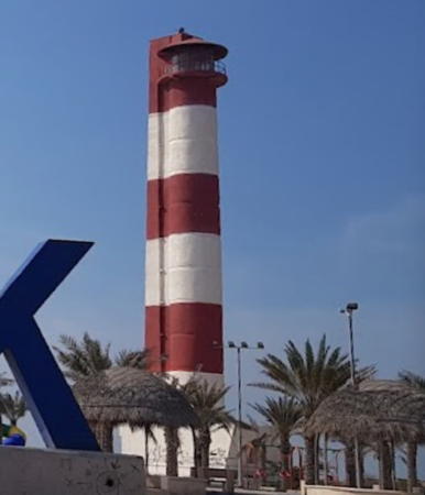
Larak Island Light
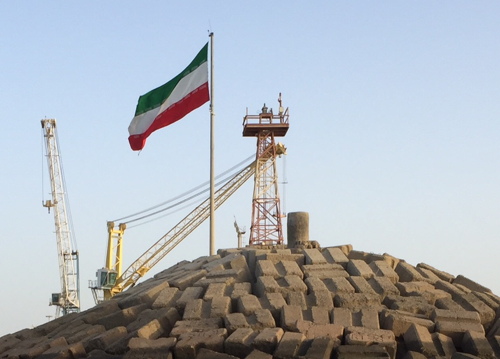
Lārak Island Light, Persian Gulf, December 2010
ex-Panoramio photo copyright Alireza Teimoury
used by permission

Sistan and Baluchestan Province Lighthouses

Chābahār County (Gulf of Oman) Lighthouses
Pasā Bandar (Pasabandar)
Date unknown. Inactive since 2023. Approx. 13 m (43 ft) square skeletal tower. No photo available but Google has a satellite view. Pasā Bandar is a small fishing port at the extreme southeastern tip of Iran, about 40 km (25 mi) from the Pakistani border. In 2015 Iran was improving the harbor and had a small naval base under construction. Located at the tip of the peninsula sheltering the harbor of Pasā Bandar. Site status unknown. ex-Admiralty D7725; NGA 28526.
Chābahār (Beheshti Port, Chah Bahar) (2)
2019 (station established 2008). Active; focal plane 38 m (125 ft); two white flashes every 10 s. Approx. 20 m (66 ft) square skeletal tower. No photo of the new tower available but Google has a satellite view. Hashem Moradi has a very distant view of the older tower. Chābahār, a city of about 70,000 in southwestern Baluchestan, has a recently-established free port. Located on the east side of the harbor entrance at Chābahār. Site status unknown. Admiralty D7720.2; NGA 28533.
Chābahār Beakwater (2?)
Date unknown. Active; focal plane about 11 m (36 ft); three green flashes every 6 s. Listed by the Admiralty as a "green pile" but Proshat Hosseini's distant 2023 street view shows a tower at least6 m (20 ft) tall. Bing has an indistinct satellite view. Located at the end of the main breakwater protecting the harbor. Site status unknown. Admiralty D7722.
Kalantari (Chābahār Pierhead)
2008. Active; focal plane 9 m (30 ft); three green flashes every 6 s. 6 m (20 ft) square pyramidal skeletal tower with gallery painted red with a white horizontal band. Saeid Hashemi's photo is at right and Google has an indistinct satellite view. Located at the end of the Kalantari quay at Chābahār. Site status unknown. Admiralty D7723; NGA 28534.

Kalantari Light, Chābahār, December 2015
ex-Panoramio photo copyright Saeid Hashemi; used by permission

Eastern Hormozgān Province Lighthouses

Jask County (Strait of Hormuz Approach) Lighthouses
The Strait of Hormuz is the narrow connection between the Persian Gulf and the Gulf of Oman. The strait is shaped like an inverted U, wrapped around the sharp northward projection of Arabia's Musandam Peninsula. At its narrowest point, the strait is 39 km (24 mi) wide. The strait and the province of Hormozgān are named for the kingdom of Hormuz (Ormus), which ruled this area from the 10th to the 17th century.
Ras-e Jask (3)
Date unknown (station established 1914). Active; focal plane 32 m (105 ft); two white flashes every 15 s. Approx. 20 m (66 ft) square skeletal tower, painted red. Obaidullah Shah Bakhsh has a 2020 distant view, Hamid Khura has a fuzzy street view, and Google has a satellite view. The original light was mounted on the telegraph office; this was replaced before 1942 by a "circular white tower." Iran established a new naval base at Jask in 2008. Located on a sharp promontory on the east side of the entrance to the Strait of Hormuz. Site status unknown. Admiralty D7713; NGA 28540.
Jask West Breakwater (1)
Date unknown. Inactive. 4.5 m (15 ft) square white concrete tower. Tareq Jashooei has a photo (also seen at right) and Google has a satellite view. The breakwater was extended and the light moved to a post at the end of the extension (focal plane 7 m (23 ft); three green flashes every 10 s). Located on the west (main) breakwater of Jask. Site status unknown. Active light: Admiralty D7714; NGA 28540.5.
Ras-e Kuh (Kuh-e Mubarak, Ras al-Kuh) (2)
Date unknown. Active; focal plane 45 m (148 ft); white flash every 10 s. Approx. 30 m (98 ft) round concrete tower with lantern and gallery. NGA lists a 20 m (66 ft) skeletal tower but Google has a good satellite view of the new tower. The lighthouse resembles the Lārak Island lighthouse seen at the top of this page. Ras-e Kuh is a prominent cape at the southeast entrance to the narrow portion of the Strait of Hormuz. Located on heights about 5 km (3 mi) north of the cape. Site status unknown. Admiralty D7712; NGA 28544.

West Breakwater Light, Jask, February 2020
Google Maps photo by Tareq Jashooei

Sirik County Lighthouse
Bandar-e Sirik
Date unknown. Active; focal plane 25 m (82 ft); three white flashes every 10 s. Approx. 22 m (72 ft) square skeletal tower. No photo available but Google has a satellite view. Located in Sirik, a small port on the east coast of the Strait of Hormuz. Site status unknown. Admiralty D7711; NGA 28548.

Minab County Lighthouse
Khowr-e Minab
Date unknown. Active; focal plane about 12 m (39 ft); white flash every 3 s. Approx. 10 m (33 ft) square skeletal tower. No photo available but Google has a satellite view. NGA lists a "beacon" with a focal plane of only 2 m (7 ft); this is either a mistake or a description of an earlier light (such a small light would be of little use at this location). Located in marshland on the approach to Minab, a fishing port with a population of about 73,000, on the northeast side of the Strait of Hormuz. Site status unknown. Admiralty D7710; NGA 28620.

Bandar Abbas County Lighthouses
Bandar Abbas (Bandar-e ‘Abbās), at the northern bend of the Strait of Hormuz, is a major seaport, naval base, and capital of Hormozgān Province. The modern port is artificial: it consists of a canal-like cut oriented precisely north and south.
Hurmoz (Hormoz) West Breakwater
Date unknown. Active; focal plane about 12 m (39 ft); green flash every 5 s. Approx. 6 m (20 ft) round concrete tower painted green. Vahid Goudarzi has a 2019 photo, Reza Arabsheibani has a distant street view, and Google has a satellite view. Hormuz Island is a rugged, roughly round island about 8 km (5 mi) in diameter about 25 km (15 mi) southeast of Bandar Abbas. Located on the west breakwater at Hormoz. Site status unknown. Admiralty D7709.9.
Hurmoz (Hormoz) East Breakwater
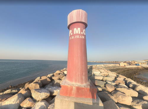
Date unknown. Active; focal plane about 12 m (39 ft); red flash every 5 s. Approx. 6 m (20 ft) round concrete tower painted red. Trabas has a photo by Alfonso Biescas Vignau, Reza Arabsheibani has the closeup street view seen at right, and Google has a satellite view. Located on the east breakwater at Hormoz. Accessible by walking the pier. Site open, tower closed. Admiralty D7709.91.
Haghani East Breakwater
Date unknown. Active; focal plane about 10 m (33 ft); green light, pattern unknown. Approx. 6 m (20 ft) round green concrete tower. Mohammad Mosapoor has a view from the harbor, Zahra Safary has a distant view of both breakwater lights, and Google has a satellite view. The busy Haghani Passenger Terminal has departures for Hurmoz and Qeshm. Located on the east breakwater of the terminal on the east side of Bandar-e Abbās. Site status unknown. Admiralty D7709.852.
Haghani West Breakwater
Date unknown. Active; focal plane about 10 m (33 ft); red light, pattern unknown. Approx. 6 m (20 ft) round red concrete tower. Mohammad Hosseini has a distant view, Zahra Safary has a distant view of both breakwater lights and Google has a satellite view. Located on the west breakwater of the terminal on the east side of Bandar-e Abbās. Site status unknown. Admiralty D7709.85.

East Breakwater Light, Hormuz, February 2020
Google Maps street view by Reza Arabsheibani
Bandar-e Abbās (Bandar Abbas) Entrance Range Rear
Date unknown. Active; focal plane about 20 m (66 ft); white light, 2 s on, 2 s off. 15 m (49 ft) square pyramidal skeletal tower, painted with red, white and blue horizontal bands. No photo available but Google has an indistinct satellite view. The front light is on a similar but shorter tower. Located about 800 m (1/2 mi) north of the north end of the port. Site status unknown. Admiralty D7709.41; NGA 28636.
#Hormozgān Terminal
Date unknown. Inactive since 2017 and apparently removed. This was an approx. 28 m (95 ft) skeletal tower. No photo available and Google's satellite view no longer shows the tower. Located at the Hormozgān oil terminal east of Shahīd Rajāī, about 15 km (9 mi) west of Bandar Abbas. Site status unknown. ex-Admiralty D7707.5; ex-NGA 28647.5.
Bandar-e Shahīd Rajāī (Shahid Rajaee) East Breakwater (2)
Date unknown. Active; focal plane about 15 m (49 ft); green flash every 5 s. Approx. 9 m (30 ft) round hourglass-shaped green fiberglass tower. Ali Nejatpour has a very distant street view from shore and Google has a satellite view. The Admiralty and NGA list a framework tower. There is probably a similar light on the inner breakwater. Located on the east outer breakwater of the Shahid Rajaee port, about 20 km (13 mi) west of Bandar Abbas. Site and tower closed. Admiralty D7708; NGA 28648.
Bandar-e Shahīd Rajāī (Shahid Rajaee) West Breakwater (2)
Date unknown. Active; focal plane about 15 m (49 ft); red flash every 5 s. Approx. 9 m (30 ft) round hourglass-shaped red fiberglass tower. Ali Nejatpour has a very distant street view from shore and Google has a satellite view. The Admiralty and NGA list a framework tower. There is probably a similar light on the inner breakwater. Located on the west outer breakwater of the Shahid Rajaee port, about 20 km (13 mi) west of Bandar Abbas. Site and tower closed. Admiralty D7708.2; NGA 28652.
Bandar-e Shahīd Rajāī (Shahid Rajaee) Entrance Range Front
Date unknown. Active; focal plane 24 m (79 ft); white light occulting once every 4 s. Approx. 20 m (66 ft) square pyramidal skeletal tower. Ali Nejatpour has a street view (a portion is at right) and Google has a satellite view. Located on the west side of Shahīd Rajāī. Site status unknown. Admiralty D7707; NGA 28647.
Bandar-e Shahīd Rajāī (Shahid Rajaee) Entrance Range Rear
Date unknown. Active; focal plane 44 m (144 ft); white light, 2 s on, 2 s off. Approx. 35 m (115 ft) square pyramidal skeletal tower. No photo available but Google has a satellite view. Located beside highway 94, 2130 m (1.3 mi) west northwest of the front light. Site status unknown. Admiralty D7707.1; NGA 28647.1.

Shahīd Rajāī Range Front Light, Bandar Abbas, October 2021
Google Maps street view by Ali Nejatpour

Qeshm County (Upper Strait of Hormuz) Lighthouses
Qeshm (formerly spelled Kishm) is the largest island of Iran. 135 km (84 mi) long, it lies parallel to the mainland coast on the north side of the Strait of Hormuz.

Jazīreh-ye Lārak (Larak Island) North
2008. Active; focal plane 40 m (131 ft); two white flashes every 10 s. Approx. 32 m (105 ft) semi-elliptical cylindrical white concrete tower with lantern and gallery, rising from a 1-story base. Alireza Teimoury's photo is at the top of this page, Hasan Vali has a 2019 photo, and Google has a street view and a satellite view. This light replaced a light on a communications tower near the center of the island. Lārak Island, southeast of Qeshm on the north side of the Strait of Hormuz, is an important oil shipment port for Iran. Located on the northern tip of the island. Accessible only by boat. Site and tower closed. ARLHS IRA-006; Admiralty D7337.5; NGA 28669.
Qeshm
Date unknown. Active; focal plane 7 m (23 ft); red flash every 5 s. 6 m (20 ft) round red fiberglass tower on a square concrete base. Vahab Kosar has a view from an arriving ferry and Google has a satellite view. Located on the breakwater of the ferry port of Qeshm city, near the east end of the island. Site status unknown. Admiralty D7337.7.
Qeshm Southeast Inner Breakwater
Date unknown. Active; focal plane about 8 m (26 ft); green flash every 5 s. 6 m (20 ft) round green fiberglass tower on a square concrete base. No photo available but Google has a satellite view. Located on the inner breakwater of the recreational harbor of Qeshm city, at the east end of the island. Site status unknown. Admiralty D7337.82.
Qeshm Southeast Breakwater
Date unknown. Active; focal plane about 8 m (26 ft); red flash every 5 s. 6 m (20 ft) round red fiberglass tower on a square concrete base. No photo available but Google has a satellite view. Located on the outer breakwater of the recreational harbor of Qeshm city, at the east end of the island. Site status unknown. Admiralty D7337.8.
Jazīreh-ye Hengām (Hengam Island) South
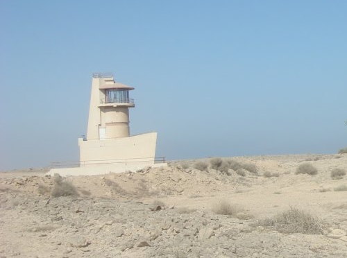
Date unknown. Active; focal plane 15 m (49 ft); white flash every 10 s. 5 m (17 ft) round tower with lantern, attached to a supporting structure. A photo of this curious light is at right and Google has a satellite view. Hengam is an island about 35 km (22 mi) in diameter lying just off the central south coast of Qeshm Island at the northwestern entrance to the Strait of Hormuz. Located near the south end of Hengam Island. Accessible only by boat. Site status unknown. Admiralty D7339.5; NGA 28684.1.
Dastakān
Date unknown. Active; focal plane 12.5 m (40 ft); three white flashes every 12 s. Approx. 8 m (26 ft) square pyramidal skeletal tower. No photo available but Google has a satellite view. Located at the southwestern tip of Qeshm Island. Site status unknown. Admiralty D7700; NGA 28732.

Hengam Island Light, Qeshm
unattributed ex-Panoramio photo salvaged by ipfs.io

Information available on lost lighthouses:

Notable faux lighthouses:

Adjoining pages: East: Pakistan | South: Oman | Southwest: United Arab Emirates | West: Southwestern Iran

Return to the Lighthouse Directory index | Ratings key

Posted October 9, 2010. Checked and revised September 11, 2023. Lighthouses: 25. Site copyright 2023 Russ Rowlett and the University of North Carolina at Chapel Hill.