Lighthouses of the Philippines: Negros and Siquijor

The Republic of the Philippines (Pilipinas in Filipino) includes more than 7600 islands stretching over 1750 km (1100 mi) of the western Pacific and separating the Philippine Sea on the east from the South China Sea on the west. The largest islands are Luzon at the northern end of the country and Mindanao at the southern end. As of 2020 the population of the country was about 109 million.

The archipelago was a Spanish colony until the Spanish-American War of 1898, which brought the islands under U.S. administration. Japan occupied the islands during World War II (1942-45) and the country became independent shortly thereafter (1946).

The Philippines is divided into 17 regions and subdivided into 81 provinces. Located in the central part of the country, the island of Negros is divided lengthwise by a volcanic mountain range. Currently the northwestern half of the island (Negros Occidental Province) is in the Western Visayas Region and the southeastern half (Negros Oriental Province) is in the Central Visayas Region. The island has a population of nearly 4.5 million. The largest cities are the two provincial capitals, Bacolad in Negros Occidental and Dumaguete in Negros Oriental. The Tañon Striat separates Negros from Cebu on the east and the Guimaras Strait separates Negros from Guimaras and Panay to the west. The north coast faces the Visayan Sea and the southwest coast faces the Panay Gulf and Sulu Sea. Spanish colonizers named the island Negros ("Blacks") after its darker-skinned inhabitants; the indigenous name of the island was Buglas.

Siquijor (pronounced "seek-e-hor") is a much smaller island lying about 30 km (19 mi) southeast of Cebu and Negros and 40 km (25 mi) southwest of Bohol. The island is about 25 km (15 mi) in diameter and has a population of about 100,000. Formerly a subprovince of Negros Oriental, Siquijor became in separate province in 1971.

Filipino and English are official languages in the Philippines. In Filipino a lighthouses is called a parola; an island is an isla or pulo. Many English maritime terms have been adopted into Filipino, including cape, bay, and port, and the names of historic lighthouses are often retained in their Spanish forms.

Lighthouses in the Philippines are maintained by the Marine Safety Services Command of the Philippine Coast Guard. Notices to Mariners are posted by the National Mapping and Resource Information Agency (NAMRIA).

Many Philippine lighthouses are not well known so better information and photos are always needed.

ARLHS numbers are from the ARLHS World List of Lights. PCG numbers are the Philippines Light List numbers, where known. Admiralty numbers are from volume F of the Admiralty List of Lights & Fog Signals. U.S. NGA List numbers are from Publication 112.

General Sources
Lighthouses in the Philippines
Photos and observations in blog entries by Loyd Martinez.
Lighthouses in the Philippines
Wikipedia article, with links to articles on several of the individual lighthouses.
Spanish Lighthouses of the Philippines
This is the Directory's own list of the Spanish light stations, with notes on their current status.
Lighthouses in the Philippines
Photos by various photographers available from Wikimedia.
World of Lighthouses - Philippines
Photos by various photographers available from Lightphotos.net.
Online List of Lights - Philippines
Photos by various photographers posted by Alexander Trabas.
Navionics Charts
Navigation chart information for Negros.
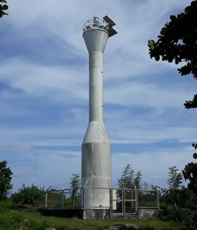

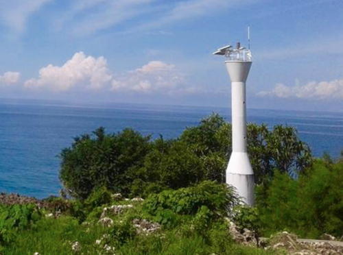
Apo Island Light, Bohol Sea, September 2018
Google Maps photo by Michael Maleriado
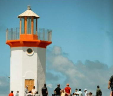

Pierhead Light, Cadiz, February 2024
Philippine News Agency photo
Negros Oriental Province Lighthouses

East Coast (Tañon Strait) Lighthouses
Guihulngan
Date unknown. Active; focal plane 11 m (36 ft); three white flashes every 12 s. Approx. 10 m (33 ft) round hourglass-shaped fiberglass tower. Entire lighthouse is white. A 2014 photo is available showing the light just south of the Guihulngan port; Google's more recent satellite view shows the lighthouse now surrounded by trees. Located in Guihulngan. Site status unknown. PCG-0235; Admiralty F2352; NGA 14764.
* Bais City (Daco Island, Dacu)
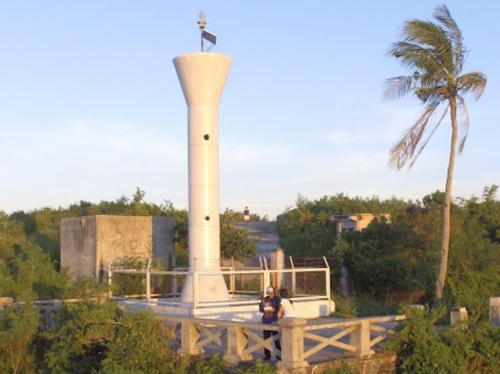
Date unknown. Active; focal plane unknown; white flash every 5 s. 10 m (33 ft) round barbell-shaped white fiberglass tower. Reginald Aragones has a 2017 closeup photo and a second photo also seen at right and Google has a satellite view. The viewing platform surrounding the base of the lighthouse provides a wide view of the sea. Located at the summit of Dacu (Dewey) Island at the harbor of Bais. Accessible by road. Site open, tower closed. Admiralty F2350.5; NGA 14775.
Amlan (Amblan) Point
2008. Active; focal plane 11 m (36 ft); white flash every 6 s. 10 m (33 ft) square metal post with gallery. Entire lighthouse is white. Ian Yee has a photo and a closeup street view, Maricris Cabrera has a 2023 photo, and Google has a satellite view. This light marks the west side of the narrowest passage between Negros and Cebu. Located on a low point near the mouth of the Amlan River. Site status unknown. PCG-0233; Admiralty F2348; NGA 14780.

South Coast (Bohol Sea and Sulu Sea) Lighthouses
* Dumaguete
Date unknown. Active; focal plane 12 m (39 ft); green flash every 5 s. 10.5 m (34 ft) square white concrete pillar mounted on a square base, with a stairway winding around the tower, rising from one end of a former passenger terminal building. A 2009 photo and a 2011 photo are available, and Google has a street view and an indistinct satellite view. The capital of Negros Oriental Province, Dumaguete is an important terminal for ferries crossing the Bohol Sea to Mindanao. Located on the wharf at Dumaguete. Site open, tower closed. PCG-0232; Admiralty F2346; NGA 14732.

Bais City Light, Bais, September 2017
Google Maps photo by Reginald Aragones
* Dumaguete Water Tower
Date unknown. Active; focal plane 30 m (98 ft); white light, 3 s on, 2 s off. Approx. 20 m (66 ft) round white concrete tower carrying a round tank. Google has a street view and a satellite view. Located on Katada Street in downtown Dumaguete. Site open, tower closed. Admiralty F2347; NGA 14736.
** [Apo Island (1)]
1917. Inactive since about 2005. 10.5 m (35 ft) concrete tower with gallery and external ladder, no lantern. 1-story keeper's house, abandoned. Edzel Rubite has a 2016 photo, Reginald Aragones has a drone view of both lighthouses, and Georg Kramer has a photo of both lighthouses. Located at the highest point of the island southeast of Zamboanguita in southernmost Negros. The island is a popular resort, and the lighthouse is accessible by hiking trails. Site open, tower can be climbed.
* Apo Island (2)
2005(?) (station established 1917). Active; focal plane 130 m (428 ft); white flash every 5 s. 11 m (36 ft) hourglass-shaped white fiberglass tower with gallery; access to the gallery is by an internal ladder. Michael Maleriado's photo is at the top of this page, Robin Directo has a 2018 photo, Robert Casaclang has a 2012 photo, Reginald Aragones has a drone view of both lighthouses, and Google has a satellite view of the station. Located close to the old keeper's house. Site open, tower closed. . Admiralty F2344; NGA 14796.
Antulang
Date unknown. Active; focal plane 26 m (85 ft); three white flashes every 15 s. 11 m (36 ft) round hourglass-shaped fiberglass tower. Entire lighthouse is white. A closeup photo, a 2023 closeup, and a view through trees are available, a Dumaguete tourist site has a photo (fourth photo on the page), and Google has an indistinct satellite view. The lighthouse is on the grounds of the Antulang Beach Resort. It is not at Siaton Point as the Admiralty Light List describes and Navionics charts. Located on Bonbonon Point, about 20 km (13 mi) east of Siaton Point, near the southern tip of Negros. Site open, tower closed. Admiralty F2345; NGA 14730.
Cansilan (Basay)
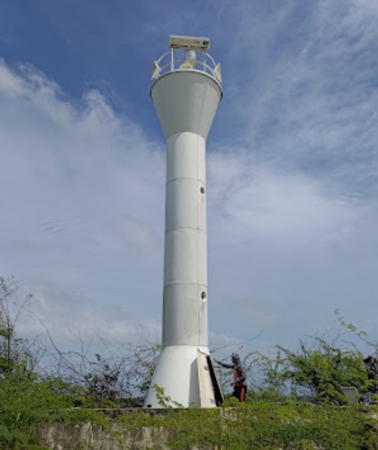
Date unknown. Active; focal plane about 26 m (85 ft); white flash every 5 s. Approx. 10 m (33 ft) round hourglass-shaped fiberglass tower. Entire lighthouse is white. Sigbun Luna has a 2018 photo (seen at right) and a view from the sea and Google has an indistinct satellite view. NGA is confused and lists this light twice. Located on a sharp promontory on the southwest coast of Negros about 15 km (9 mi) west of Bayawan. A trail descends from the highway to the light, but no parking is provided. Site open, tower closed. PCG-0742; Admiralty F2359.82; NGA 14718 (=14729).

Cansilan Light, Basay, June 2018
Google Maps photo by Sigbun Luna

Negros Occidental Province Lighthouses

West Coast (Sulu Sea and Panay Gulf) Lighthouses
Taliptipun (?)
2016. Active; focal plane unknown; white flash every 5 s. Approx. 10 m (33 ft) white fiberglass tower with gallery. No photo available. The location of this lighthouse is uncertain. Google has a satellite view of the listed location but no lighthouse is visible in that vicinity. Another Google satellite view may show the lighthouse near the coast. Located off the National Highway at Da-Og Point in the Hinoba-An municipality on the southwest coast of Negros. Site status unknown. PCG-0740; Admiralty F2359.78.
Matatindoc Point (Sipalay)
Date unknown. Active; focal plane unknown; white flash every 5 s. Approx. 10 m (33 ft) round barbell-shaped white metal and fiberglass tower. Jocar Acebuche has a 2022 street view and Google has a satellite view. Located on a headland marking the southwesternmost tip of Negros, about 5 km (3 mi) southwest of Sipalay. Site status unknown. PCG-0770; Admiralty F2359.75.
* Sojoton Point (Cayauan)
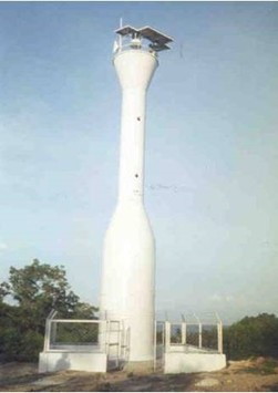
Date unknown. Active; focal plane unknown but probably at least 30 m (98 ft); two white flashes every 10 s. Approx. 11 m (36 ft) round barbell-shaped white metal and fiberglass tower. James Calzado has a 2021 closeup, a 2018 photo (also seen at right) and a second photo are available, and Google has a street view through trees and a distant satellite view. There is an observation deck next to the lighthouse. Located atop a high promontory at the southwestern corner of Negros, marking the south side of the entrance to the Panay Gulf from the Sulu Sea. Accessible by road and a short walking trail; limited parking is available. Site open, tower closed. PCG-0228; Admiralty F2359.7; NGA 14717.
Himamaylan
Date unknown. Active; focal plane 7 m (23 ft); reed flash every 5 s. 7 m (23 ft) concrete tower. No photo available but Google has an indistinct satellite view. Located on mud flats on the south side of the entrance to Himamaylan. Site status unknown. PCG-0550; Admiralty F2359.5; NGA 14716.
Pontevedra (?)
Date unknown. Active; focal plane unknown; red light, pattern unknown. No description and no photo available. Google has a satellite view of the listed location but no lighthouse is visible in that vicinity. Another Google satellite view may show the lighthouse on the south side of the entrance to the Marayo River in Pontevedra, a city of about 55,000 residents at the northern end of the Panay Gulf. Site status unknown. Admiralty F2359.4.

Northwest Coast (Guimaras Strait) Lighthouses
Pulupandan
Date unknown. Active; focal plane about 14 m (46 ft); red flash every 5 s. Approx. 10 m (33 ft) round barbell-shaped white metal and fiberglass tower. The light is seen in Ronn Elmer Antazo's 2023 video, a view from the sea is available, and Google has a satellite view. Located at the end of a pier at Pulupandan, a port and ferry terminal on the central west coast of Negros; ferries link Pulupandan to San Lorenzo, Guimaras. Site status unknown. PCG-0459; Admiralty F2359; NGA 14686.7.
* Bredco
Date unknown. Active (privately maintained?); focal plane about 12 m (39 ft); white flash every 5 s. Described by the light lists as a "tower," this light is actually on a mast centered on a large palm oil tank at the end of an indusrial quay. Google has a street view and a satellite view. Bredco is an acronym for the Bacolad Real Estate Development Corporation, which developed this port on a rectangular landfill. The tank is owned by ARES Merchants, a Singapore company. Located on the main quay at Bacalod. Site open, tower closed. PCG-0227; Admiralty F2358.5; NGA 14686.2.

Sojoton Point Light, Cayauan, August 2018
Google Maps photo by limitsfound
* Bacalod (Banago Wharf)
Date unknown. Active; focal plane about 16 m (52 ft); two red flashes every 5 s. Light mounted atop the Philippines Port Authority building. A photo is available and Google has a street view and a satellite view. With a population of more than half a million the provincial capital of Bacolod is the second largest city of the Visayas and a major port. Located at the end of the Banago wharf. Accessible by driving the pier. Site open, tower closed. PCG-0226; Admiralty F2358.2; NGA 14686.
Tomonton (Tomongtong) Point
Date unknown. Active; focal plane 12 m (39 ft); two white flashes every 6 s. Approx. 10 m (33 ft) round barbell-shaped white metal and fiberglass tower. No photo available but Google has an indistinct satellite view. Located on a marshy point at the northwestern corner of Negros. Site open, tower closed. PCG-0651; Admiralty F2357.7; NGA 14681.
Victorias
Date unknown. Active; focal plane about 10 m (33 ft); continuous green light. White tower on a square platform. At extreme zoom the light can be seen just to the left of center in Nelgine Lumihoc's view from the Baybay Mangrove Eco-Trail. Google has a distant satellite view. A city in northwestern Negros, Victorias is a terminal for ferries crossing the Guimaras Strait from Culasi Ajuy, Guimaras. The traditional ferry port is on the twisting Malijao River, but there is a new ferry port about 10 km (6 mi) to the west. Located on the west side of the channel entering the Malijao River. Accessible only by boat. Site open, tower closed. Admiralty F2357.6; NGA 14680.

North Coast (Visayan Sea) Lighthouses
Cadiz Entrance
Date unknown. Active; focal plane about 12 m (39 ft); red light, pattern unknown. Approx. 12 m (39 ft) mast atop a round white concrete tower with gallery. Jappet Gella has a distant view from shore and Bing has a distant satellite view. Located on the west (right) side of the entrance to Cadiz. Accessible only by boat. Site open, tower closed. Admiralty F2357.5.
* Cadiz (2)
Date unknown. Inactive since 2024. Approx. 18 m (59 ft) mast atop a 2-story port operations building. Marvin Espesor has a photo and Google has a satellite view. NGA lists a "wooden post" for this light. Located at the end of a long pier at Cadiz, a city of about 155,000 people at the north end of Negros. Accessible by driving the pier. Site open, tower closed. Admiralty F2357.4; NGA 14676.
* Cadiz (3)
2024. Active; focal plane about 13 m (43 ft); white flash every 5 s. Approx. 9 m (30 ft) octagonal tower with lantern and gallery, painted white with red trim. A photo is at the top of this page and Miguel Sedurifa has a November 2023 photo but the light is too new to appear in Google's satellite view. Located at the end of the pier at Cadiz. Accessible by walking the pier. Site open, tower closed. Not (yet) listed by the Admiralty.
Matabas Island
Date unknown. Active; focal plane about 13 m (43 ft); white flash every 5 s. 10 m (33 ft) round hourglass-shaped white metal and fiberglass tower. John Carlo Bual's 2023 photo is at right, Minda Monica Ponce-Rodriguez has a distant view from the sea, and Google has a satellite view. This light marks a narrow passage between Negros and Bantayan Island, Cebu Province. Located on the northwest corner of a small but inhabited island on a reef off the northeastern corner of Negros. Accessible only by boat. Site open, tower closed. Admiralty F2356.6; NGA 14750.

Matabas Island Light, Visayan Sea, March 2023
Google Maps photo by John Carlo Bual

Northeast Coast (Tañon Strait) Lighthouses
Escalante (Danao River) (2)
Date unknown. Active; focal plane 11 m (36 ft) (?); NGA lists a continuous red light but Navionics shows a white light. Originally a 10 m (33 ft) white concrete tower, but a photo by Neil Murite shows that the tower has been extended, perhaps to as much as 20 m (66 ft). Google has an indistinct satellite view. NGA describes the light as being "on ruins of wharf in Danao River," but the wharf has been rebuilt and no longer carries the light. Escalante, at the northeastern corner of Negros, is the terminal for ferries to Tabuelan in Cebu. Located near the new wharf. Site status unknown. PCG-0238; Admiralty F2356.4; NGA 14748.
Buenavista (Escalante)
Date unknown. Active; focal plane about 12 m (39 ft); light characteristic unknown. Approx. 10 m (33 ft) round hourglass-shaped white metal and fiberglass tower. No photo available but Bing has a satellite view. Located a short distance south of the Danao River entrance. Site status unknown. Admiralty F2356.2.
Refugio Island (Sipaway Island)
1913. Active; focal plane 37 m (121 ft); white flash every 7 s. 17 m (55 ft) square white steel tower with gallery. A 2020 photo is available and Google has a satellite view. Located on the northeastern shore of Refugio (Sipaway) Island, which protects the harbor of San Carlos City on the eastern coast of Negros. Site status unknown. ARLHS PHI-049; PCG-0236; Admiralty F2354; NGA 14744.
* San Carlos (3)
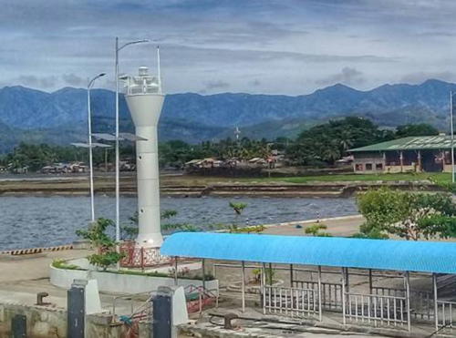
Date unknown (station established 1913). Active; focal plane about 20 m (66 ft); two red flashes every 10 s. Approx. 16 m (52 ft) round hourglass-shaped concrete tower, painted white. A photo is at right, Jessamae Baje has a 2018 photo, Mark John Peña has a photo, Roy Espina has a street view, and Google has a satellite view. The light lists descibe a much shorter tower. San Carlos is a city of about 135,000 residents and the terminal for ferries crossing the Tañon Strait to Toledo, Cebu. Located on the ferry pier at San Carlos. Site open, tower closed. PCG-0237; Admiralty F2356; NGA 14740.

San Carlos Light, San Carlos, March 2010
ex-Panoramio photo copyright Marlon "Villegas" Briones; used by permission

Siquijor Province Lighthouse

Siquijor Lighthouses
Minarcahan Point
Date unknown. Active; focal plane 8.5 m (28 ft); three white flashes every 10 s. 8 m (26 ft) round barbell-shaped fiberglass tower. Entire lighthouse is white. A Coast Guard photo is at right and Bing has a satellite view. Located at the northern tip of Siquijor. Site status unknown. PCG-0799; Admiralty F2367; NGA 14783.
Minalulan Point
1999. Active; focal plane 56 m (184 ft); white flash every 10 s. 20 m (66 ft) round tower. Entire lighthouse is white. Adam Clemons has a distant view from the sea, Nico Rodriguez has a distant view, and Bing has a satellite view. Located in Lazi Municipality on the southeastern tip of the island. Site status unknown. ARLHS PHI-111; PCG-0518; Admiralty F2369; NGA 14793.
* [Lazi]
Date unknown. Active; focal plane unlisted; continuous red light. Light mounted on a square concrete pillar outside the 1-story harbormaster's office. A photo is available, Arniel Laureles has a drone view, Van Ambruce Ligutom has a street view, and Google has a satellite view of the wharf. Located on the quay at Lazi, at the eastern end of Siquijor. Site open, tower closed. PCG-0285; Admiralty F2370; NGA 14792.
Calambaguio
Date unknown. Active; focal plane 27 m (89 ft); three white flashes every 10 s. Approx. 12 m (39 ft) round barbell-shaped fiberglass tower. Entire lighthouse is white. A realtor has a photo and Google has a satellite view and a distant street view. Located on heights in San Juan above the south coast of Siquijor. Site status unknown. PCG-0744 (?); Admiralty F2371; NGA 14791.

Minarcahan Point Light, Siquijor
Philippines Coast Guard photo

Information available on lost lighthouses:

Notable faux lighthouses:

Adjoining pages: East: Cebu | South: Northern Mindanao | Northwest: Panay and Guimaras

Return to the Lighthouse Directory index | Ratings key

Posted July 24, 2005. Checked and revised December 12, 2023. Lighthouses: 26. Site copyright 2023 Russ Rowlett and the University of North Carolina at Chapel Hill.