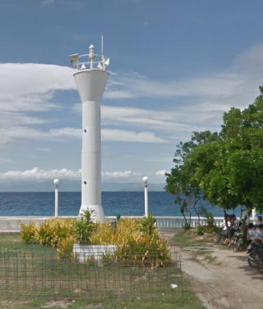
Lighthouses of the Philippines: Cebu

The Republic of the Philippines (Pilipinas in Filipino) includes more than 7600 islands stretching over 1750 km (1100 mi) of the western Pacific and separating the Philippine Sea on the east from the South China Sea on the west. The largest islands are Luzon at the northern end of the country and Mindanao at the southern end. As of 2020 the population of the country was about 109 million.

The archipelago was a Spanish colony until the Spanish-American War of 1898, which brought the islands under U.S. administration. Japan occupied the islands during World War II (1942-45) and the country became independent shortly thereafter (1946).

The country is divided into 17 regions and subdivided into 81 provinces. The Province of Cebu is part of the Central Visayas Region. Cebu is a long but narrow island, 225 km (140 mi) from north to south but only 45 km (28 mi) wide at its widest point. With a population of more than 3 million, Cebu is the most densely populated island of the central Philippines. On the west the Tañon Strait separates Cebu from Negros; on the east the Camotes Sea separates northern Cebu from Leyte and the Cebu (or Bohol) Strait separates southern Cebu from Bohol.

Filipino and English are official languages in the Philippines. In Filipino a lighthouses is called a parola; an island is an isla or pulo. Many English maritime terms have been adopted into Filipino, including cape, bay, and port, and the names of historic lighthouses are often retained in their Spanish forms.

Lighthouses in the Philippines are maintained by the Marine Safety Services Command of the Philippine Coast Guard. Notices to Mariners are posted by the National Mapping and Resource Information Agency (NAMRIA).

Many Philippine lighthouses are not well known so better information and photos are always needed.

ARLHS numbers are from the ARLHS World List of Lights. PCG numbers are the Philippines Light List numbers, where known. Admiralty numbers are from volume F of the Admiralty List of Lights & Fog Signals. U.S. NGA List numbers are from Publication 112.

General Sources
Lighthouses in the Philippines
Photos and observations in blog entries by Loyd Martinez.
Online List of Lights - Philippines
Photos by various photographers posted by Alexander Trabas. Photos from this area are by Rainer Arndt and Thomas Philipp.
Lighthouses in the Philippines
Wikipedia article, with links to articles on several of the individual lighthouses.
Spanish Lighthouses of the Philippines
This is the Directory's own list of the Spanish light stations, with notes on their current status.
Lighthouses in the Philippines
Photos by various photographers available from Wikimedia.
World of Lighthouses - Philippines
Photos by various photographers available from Lightphotos.net.
Navionics Charts
Navigation chart information for Cebu.
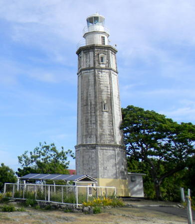

Bagacay Point Light, Cebu, April 2012
Wikimedia Creative Commons photo by P199
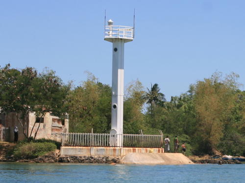
 
Visayan Sea Lighthouses
The Visayan Sea occupies an elliptical basin in the center of the Philippines. The islands of Cebu and Negros are to the south, Panay to the southwest, Leyte to the southeast, and Masbate to the north.
Bantayan
Date unknown. Active; focal plane 12 m (39 ft); two white flashes every 5 s. 10 m (33 ft) square white metal tower with gallery. Wikimedia has John Perry's photo at right and Bing has a satellite view. Bantayan is an island off the northwestern end of Cebu; it has a population of about 150,000. Located on the beach on the southwest side of the island and about 2 km (1.2 mi) north of the island's ferry wharf. Site status unknown. PCG-0222; Admiralty F2298; NGA 14660.
* Bontay (Buntay) Point (Madridejos)
1989. Active; focal plane 10 m (33 ft); white flash every 5 s. 10 m (33 ft) white concrete post light with gallery centered on a robust round concrete pier. Allan Jarina has a photo, another photo is available, and Google has a satellite view. Located on the beach at the northern tip of Bantayan Island. Site open; a ladder allows visitors to climb atop the pier. PCG-0215; Admiralty F2300; NGA 14664.
Tanguingui Island (3)
1994 (station established 1890s). Active; focal plane 39 m (128 ft); two white flashes every 5 s. 34.5 m (113 ft) octagonal cylindrical steel tower with lantern and gallery. Entire lighthouse is white. The 1-story concrete keeper's house and other station buildings are in ruins. Iam Myand has a 2022 photo, a 2010 view from the sea is available and Bing has a satellite view. This light is a sibling of the Manigonigo and North Gigante lighthouses. Nothing is known of the Spanish lighthouse here. The U.S. built a 14 m (45 ft) lighthouse in 1904. Located on Tanguingui, an island in the middle of the Visayan Sea about 20 km (12.5 mi) north of Buntay Point, Bantayan, and about 100 km (60 mi) east of the northeastern point of Panay. Accessible only by boat. Site status unknown. . ARLHS PHI-100; PCG-0192; Admiralty F2296; NGA 14652.
Guintacan (Kinatarcan) Island
1999. Active; focal plane 65 m (213 ft); white flash every 10 s. 20 m (66 ft) white octagonal metal tower. A photo (halfway down the page) is available and Google has a distant satellite view. Located on Guintacan, a popular resort island about 20 km (13 mi) northwest of Daanbantayan at the northern end of Cebu. Site status unknown. ARLHS PHI-027; PCG-0503;Admiralty F2297; NGA 14665.

Bantayan Light, Bantayan. March 2013
Wikimedia Creative Commons photo by John M. Perry
Chocolate (Paji, Padji) Island
1994. Active; focal plane 52 m (170 ft); white flash every 5 s. 10 m (33 ft) white concrete tower. Trabas has Philipp's distant view, John Mio Oclarit has a very distant 2022 view, and Google has an indistinct satellite view. Located on a small island about 2 km (1.25 mi) off the northern tip of Cebu and 6 km (3.5 mi) southwest of Malapascua Island (next entry). Accessible only by boat. Site status unknown. ARLHS PHI-103; PCG-0239; Admiralty F2410; NGA 14808.
** Malapascua Island (2)
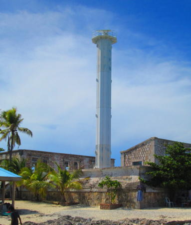
1994 (station established 1913). Active; focal plane 34 m (112 ft); two white flashes every 10 s. Approx. 16 m (52 ft) octagonal cylindrical steel tower with lantern and gallery, painted white. A photo is at right, a 2023 photo is available, Denver Gevero has 2021 photo, there's a November 2007 closeup by Christie Manguiat, Trabas has Philipp's photo, and Google has a satellite view and a street view taken from the base of the lighthouse. The original lighthouse was an 11 m (36 ft) wood skeletal tower, and NGA still lists 37 ft as the tower height. Located on Malapascua, an island about 25 km (15 mi) northeast of Bogo in northeastern Cebu. Site open, tower can be climbed if you locate a local guide who has a key. . ARLHS PHI-089; PCG-0240; Admiralty F2412; NGA 14812.
Carnaza (Carnasa) Island
1994. Active; focal plane unknown; two white flashes every 5 s. Approx. 10 m (33 ft) round barbell-shaped white fiberglass tower. A photo is available and Bing has a fuzzy satellite view. Located on Carnaza, a small island in the Visayan Sea about 20 km (13 mi) north of Malapascua Island. Site status unknown. Admiralty F2412.5; NGA 14810.

Camotes Islands Lighthouse
The Camotes Sea occupies a basin north of Bohol and between Cebu and Leyte. The four Camotes Islands are in the center of the Camotes Sea roughly 65 km (40 mi) east northeast of Cebu City. The islands have a total population of about 100,000.

*
Pilar (Ponson Island)
2002. Active; focal plane 13 m (43 ft); two white flashes every 10 s. 9.5 m (31 ft) round barbell-shaped tower. Entire lighthouse is white. Michael Wilkins has a distant street view from the town pier and Google has a fuzzy satellite view. Located south of the town pier at Pilar, a town at the northeastern end of Ponson, the easternmost of the Camotes islands. Site open, tower closed. PCG-0617; Admiralty F2442.2; NGA 14971.

Malapascua Island Light, Cebu
Cebu tourist develpment photo from Lakwatsero.com
Tudela
Date unknown. Active; focal plane 48 m (157 ft); continuous red light. NGA lists a 10 m (33 ft) white concrete tower but the listed location of the light is a communications tower seen in a photo of the Top View resort and no concrete tower has found elsewhere in the area. Google has a satellite view of the listed location. Located atop a steep bluff east of the port of Tudela on the central south coast of Poro Island. Site status unknown. Admiralty F2437; NGA 14964.
* Poro Island
2002. Active; focal plane about 13 m (43 ft); white flash every 7 s. 9.5 m (31 ft) round barbell-shaped white tower. A view from the sea is available, Wesley Chung has a street view from the dock (a portion is seen at right), and Google has a satellite view. Poro is the central island of the Camotes, and the largest. Located on the east side of the quay at Poro town, near the southwestern tip of the island. Site open, tower closed. Admiralty F2436.8; NGA 14969.
Pacijan
Date unknown. Active; focal plane about 12 m (39 ft); two white flashes every 10 s. Approx. 10 m (33 ft) round barbell-shaped tower. Entire lighthouse is white. Jeffrey Soriano has a distant view and Google has a satellite view. Located on the southwest coast of Pacijan, the westernmost of the Camotes. Site status unknown. Admiralty F2436.7; NGA 14958.2.
Tulang
1993. Active; focal plane about 20 m (66 ft); three white flashes every 15 s. Approx. 10 m (33 ft) round barbell-shaped tower. Entire lighthouse is white. Rogelio Otero has a 2021 photo and Google has a satellite view. Located on the northwestern tip of Tulang, an islet off the northwestern tip of Pacijan. Accessible only by boat. Site status unknown. PCG-0310; Admiralty F2436.3; NGA 14957.

Poro Island Light, Cebu, September 2018
Google Maps photo by Wesley Chung

Northeast Cebu Coast (Camotes Sea) Lighthouses
Bogo Bay
Date unknown. Active; focal plane 7 m (23 ft); red flash every 5 s. 7 m (23 ft) square concrete tower with gallery carrying red diamond daymarks. No photo available but Google has a satellite view. Bogo is a major ferry terminal on the northeast coast of Cebu, with ferry service to several ports in Leyte and Masbate. Located on the north side of the harbor entrance. Accessible only by boat. Site open, tower closed. PCG-0247; Admiralty F2408; NGA 14804.
Capitancillo Island (2)
1990s (?) (station established 1905). Active; focal plane 30 m (98 ft); three white flashes every 10 s. 25 m (83 ft) slender octagonal cylindrical steel tower with lantern, painted white. 1-story stone keeper's house in ruins. A photo is at right, Llöyd Cárdenas has a 2023 photo, Jade Villegas has a 2021 photo, Marcelino Rapayla has a photo, Tonee Despojo has a photo, and Google has a satellite view. Nothing remains of the original lighthouse, a cast iron tourelle. Located on Capitancillo, a small island about 10 km (6 mi) southeast of Bogo in northeastern Cebu. Site open, tower closed. ARLHS PHI-079; PCG-0248; Admiralty F2406; NGA 14800.
* Bagacay Point (Punta Bagacay, Liloan) (2)
1874 (station established 1857). Inactive at least since 1908. Approx. 5 m (17 ft) round stone tower. Joey Regis has a 2009 photo, another photo is available, Jay Dilan has a closeup, and Google has an indistinct satellite view. This is one of the oldest lighthouses in the Philippines, but it is obviously endangered. Site open, and the ruined tower is also open.
* Bagacay Point (Liloan) (3)
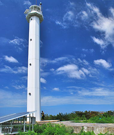
1908 (U.S) (station established 1857). Active; focal plane 44 m (146 ft); white flash every 5 s. 22 m (72 ft) octagonal concrete and stone tower with lantern and gallery. The tower is unpainted; lantern painted white. A photo is at the top of this page, Louraine Mae Sayson has a 2021 photo, Melissa de la Cruz has a 2010 photo, Lighthouse Digest has an article on the history of the station, and Google has a street view and a satellite view. This one of the earliest lighthouses to be built in the Philippines by the U.S. administration. By 2000 the lighthouse was reported to be in poor condition, but in March 2004 a group called Coastal Highpoint Ventures Inc. signed an agreement with the Coast Guard to restore and renovate the light station. The lighthouse looks to be in rather good condition in Panili's photo at the top of the page and in Benjo Rulona's October 2007 photo. The light marks the entrance to the Mactan Channel, which leads to Cebu City. Located on the point near Liloan, about 18 km (11 mi) northeast of Cebu City. Site open, tower closed. . ARLHS PHI-066; PCG-0250; Admiralty F2402; NGA 14824.

Capitancillo Island Light, Cebu, May 2018
Wikimedia Creative Commons photo by Defenestrated Juan

Cebu City Lighthouses
Cebu City is the metropolis of the Visayas with a population of nearly one million in the city and three million in the metropolitan area. The harbor of the city is a narrow strait protected by Mactan Island, which has an additional population of nearly one half million. Two bridges cross the strait.
* Tilhaon (Porters Marina)
Date unknown. Active (privately maintained); focal plane about 18 m (59 ft); continuous white light. Approx. 16 m (52 ft) round tower rising from a 1-story pierhead building and surrounded by an observation deck. Lighthouse painted with red, white and blue horizontal bands. A photo is available, Philix Mascardo has a photo of the light in action, and Google has a satellite view. Located at the end of the east pier of the marina in Calero, on the east side of Cebu City. Site open, tower closed. PCG-0744 (?); Admiralty F2401; NGA 14826.
Bantolinao Point (2)
Date unknown. Active; focal plane 9 m (30 ft); green flash every 5 s. 9 m (30 ft) round green fiberglass tower mounted on a square concrete pier. Von Ilao has a distant sea view and Bing has a fuzzy satellite view. The original light was on a square concrete post with gallery. Located off the northern tip of Mactan Island, which shelters the harbor of Cebu City, marking the northern entrance to the harbor. Accessible only by boat but easily seen from shore. Site open, tower closed. PCG-0260; Admiralty F2400; NGA 14828.
* Cebu Capitol
Date unknown (1937?). Possibly still active but unofficial since 2006. Light mounted atop the dome of the Cebu Provincial Capitol. Google has a street view and a satellite view. An Instagram photo shows how the dome is illuminated at night. The building was built in 1937. The Admiralty dropped this light in 2006 because it had become obscured by tall waterfront buildings. Located at the northern end of Osmeña Boulevard about 3 km (2 mi) north of the waterfront in downtown Cebu City. Site and building open. ARLHS PHI-102; ex-Admiralty F2392; ex-NGA 14840.
* Lapu Lapu City (Opon, Muelle Osmeña)
Date unknown. Active; focal plane 10 m (33 ft); red flash every 3 s. 8 m (26 ft) square light tower atop a 2-story pier building. Lighthouse painted white with red trim. A photo is at right, Richard Juanir has a photo, Norman Tejo has a photo, Lemuelle Moninio has a photo showing the lighthouse decked out for a holiday, and Google has a street view and a satellite view. Located on the traditional ferry wharf at Lapu-Lapu, on Mactan Island opposite the Cebu City waterfront. Site open, tower closed. PCG-0258; Admiralty F2398; NGA 14845.4.
Shell Island
Date unknown. Active; focal plane about 12 m (39 ft); two very quick white flashes every 4 s. 11 m (36 ft) round barbell-shaped tower. Entire lighthouse is white. A photo (misidentified by a commenter as Kawit Point) is available, Lightphotos.net has a good photo, and Google has a satellite view. Located on a small island opposite the Cebu City waterfront. Accessible only by boat. Site status unknown. PCG-0262; Admiralty F2393; NGA 14845.

Lapu Lapu Light, Lapu Lapu, August 2018
Google Maps photo by Wannabthat Girl
* Cauit Island (Kawit Point) (2)
1998. Active; focal plane about 14 m (46 ft); white flash every 5 s. Approx. 12 m (39 ft) round barbell-shaped tower. Entire lighthouse is white. Tommy Ladislao Arriesgado has a 2023 photo, Lightphotos.net has a 2014 view from the sea, and Google has a 2018 street view and a satellite view. Kawit was formerly a small island off the coast just south of Cebu City, but the South Reclamation Project has joined the island to the mainland to form a new port area. A large building was built behind the lighthouse in 2022-23. Located at what was once the eastern point of the island. Site open, tower closed. PCG-0252; Admiralty F2390; NGA 14846.
Lauis Ledge (2)
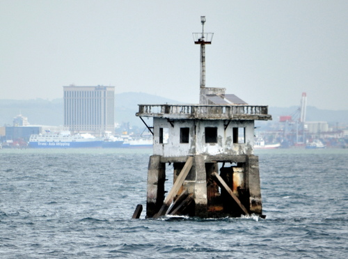
1998. Active; focal plane 16 m (52 ft); white flash every 10 s. 8.5 m (28 ft) mast atop a square concrete "dwelling" supported by piles. Entire lighthouse is white. A photo is at right, another photo is available, and Google has a satellite view. Obviously endangered; Timothy Lamoste's 2023 photo shows its poor condition.This light marks the southern entrance to Cebu City harbor. Located about 800 m (1/2 mi) off the southwestern tip of Mactan Island. Accessible only by boat. Site open, tower closed. PCG-0261; Admiralty F2388; NGA 14848.

Southeast Cebu Coast (Cebu Strait) Lighthouses
* Naga
2016 (?). Active; focal plane about 18 m (56 ft); white flash every 5 s. Approx. 16 m (52 ft) octagonal concrete tower with lantern and gallery centered on a square concrete tower with castellated top. Entire lighthouse is white. A closeup 2020 photo and a photo of the top of the tower is available and Google has a street view and a satellite view. The building is a Coast Guard Substation. Located at the northeast corner of the main quay at Naga, a city of 115,000 residents about 20 km (13 mi) southwest of Cebu City. Site open, tower closed. Admiralty F2389.
Argao
Date unknown. Active; focal plane unknown; two white flashes every 5 s. Approx. 10 m (33 ft) round barbell-shaped fiberglass tower. Entire lighthouse is white. No photo available and the tower is not seen in Google's satellite view. Located on a sandy point in Argao, on the southeast coast of Cebu. Site status unknown. Admiralty F2374.5; NGA 14866.

Lauis Ledge Light, Cebu, October 2012
Flickr photo copyright b0000rdz; permission requested
Sumilon Island
Date unknown. Active; focal plane unknown; white flash every 5 s. Approx. 17 m (56 ft) round concrete tower with gallery, an exterior ladder and four large buttresses at the base. The lighthouse is unpainted. Brennan Mercado has a closeup photo, another photo is available (fourth photo on the page), Potski Alvarez has a 2021 drone view, Mark Anthonie Bello has a street view of the base of the lighthouse, and Google has a distant satellite view. This lighthouse has an unusual design and we need information on its history; Navionics charts it as an "Old Tower." Sumilon is a small island about 2.5 km (1.5 mi) off the municipality of Oslob near the southeastern tip of Cebu. Located on the south side of the island. Accessible only by boat. Site open; nothing prevents visitors from climbing the tower, although this is dangerous. Site manager: Bluewater Sumilon Island Resort. Admiralty F2344.5; NGA 14781.

West Cebu Coast (Tañon Strait) Lighthouses
The Tañon Strait separates Cebu from the island of Negros to the west. The strait is roughly 20-25 km (13-15 mi) wide for most of its length but it narrows to 5 km (3 mi) at its southern end.

*
Ginatilan (Looc Point)
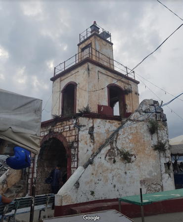
2002. Active; focal plane about 12 m (39 ft); white flash every 7 s. 9.5 m (31 ft) round hourglass-shaped white tower. A photo is available and Google has a street view seen at right and a satellite view. Located on the waterfront at Ginatilan on the southwest coast of Cebu. Site status unknown. PCG-0618; Admiralty F2359.85; NGA 14774.
Pescador Island
1999. Active; focal plane 25 m (82 ft); white flash every 5 s. 10 m (33 ft) round hourglass-shaped white tower. A distant view from the sea is available and Google has a distant satellite view. The island is a nature reserve. Located atop a small island about 10 km (6 mi) northwest of Badian on the southwest coast of Cebu. Site status unknown. ARLHS PHI-113; PCG-0246; Admiralty F2366; NGA 14772.
* Dumanjug (Tangil Wharf)
1988. Active; focal plane 10 m (33 ft), red flash every 5 s. 9.5 m (31 ft) round hourglass-shaped white tower. Shad Christian has a 2023 view and Google has a street view and an indistinct satellite view. Tangil is the terminal for ferries crossing the Tañon Strait from Guinbuingan, Negros. Located at the base of the Tangil Wharf, about 3 km (2 mi) north of Dumanjug on the southwest coast of Cebu. Site open, tower closed. ARLHS PHI-107; Admiralty F2364; NGA 14768.

Looc Point Light, Ginatilan, November 2016
Google Maps street view
* Toledo
Date unknown. Active; focal plane unlisted, red flash every 5 s. Approx. 12 m (36 ft) hexagonal (possibly octagonal) concrete post with a small lantern reached by an external spiral stairway. Nolly Senteciera has the 2017 photo seen at right, another good photo is available, and Google has a street view and a satellite view. Toledo is a city of about 210,000 residents on the west coast of Cebu about 70 km (45 mi) west of Cebu City. Ferries cross the Tañon Strait to Toledo from San Carlos, Negros. Located near the ferry wharf. Site open, tower status unknown; it may be possible to climb the external stairway. ARLHS PHI-122; PCG-0243; Admiralty F2363; NGA 14760.
* Balamban (2)
1981. Active; focal plane 13 m (43 ft); white flash every 5 s. 8.5 m (28 ft) concrete post with gallery, adjacent to a small equipment shed. Google has a street view and a satellite view. Located at Balamban, a city of about 100,000 residents, about 20 km (13 mi) north of Toledo. The caption on the linked photo calls this the "new lighthouse." Site open, tower closed. PCG-0242; Admiralty F2362; NGA 14752.
[Tabuelan]
Date unknown. Active; focal plane 6 m (20 ft); white flash every 5 s. 6 m (20 ft) white post. Lightphotos.net has a photo and Edz Nieves has a view from a passing ferry, but the small light is not seen in Google's satellite view. Tabuelan, a town of about 30,000 residents, is a ferry terminal for ferries crossing the Tañon Strait from Escalante, Negros. Located on the south side of the approach to Tabuelan. Site status unknown. PCG-0657; Admiralty F2405; NGA 14819.
Hagnaya Bay
Date unknown. Active; focal plane 14 m (46 ft); red flash every 5 s. 14 m (46 ft) white tower mounted on a round concrete pier. No photo available but Bing has a satellite view. Hagnaya, in the municipality of San Remigio, is a port on the northwestern coast of Cebu and a major terminal for ferries to Bantayan Island and to Cawayan across the Visayan Sea in Masbate. Located on the east side of the entrance to Hagnaya Bay and the port of Hagnaya. Accessible only by boat. Site open, tower closed. PCG-0241; Admiralty F2360; NGA 14816.
Medellin
Date unknown. Active (?) (privately maintained); focal plane about 12 m (39 ft); red light, pattern unknown. No photo or description available but Google's satellite view is consistent with a white fiberglass tower about 10 m (33 ft) tall. The light guides vessels to a large sugar mill. It was dropped from the PCG list in July 2023 but so far it remains on the Admralty list. Located on the shore of Hagnaya Bay south of Medellin. Site and tower closed. Owner/site manager: Bogo-Medellin Milling Company. ex-PCG-0678; Admiralty F2360.4.
 

Toledo Light, Toledo, August 2017
Google Maps photo by Nolly Senteciera
 

Information available on lost lighthouses:

Notable faux lighthouses:

Adjoining pages: Northeast: Leyte and Biliran | Southeast: Bohol and Siquijor | West: Negros

Return to the Lighthouse Directory index | Ratings key

Posted July 24, 2005. Checked and revised December 3, 2023. Lighthouses: 33. Site copyright 2023 Russ Rowlett and the University of North Carolina at Chapel Hill.