Lighthouses of the Philippines: Zamboanga and Sulu

The Republic of the Philippines (Pilipinas in Filipino) includes more than 7600 islands stretching over 1750 km (1100 mi) of the western Pacific and separating the Philippine Sea on the east from the South China Sea on the west. The largest islands are Luzon at the northern end of the country and Mindanao at the southern end. As of 2020 the population of the country was about 109 million.

The archipelago was a Spanish colony until the Spanish-American War of 1898, which brought the islands under U.S. administration. Japan occupied the islands during World War II (1942-45) and the country became independent shortly thereafter (1946).

Mindanao, the second largest island of the Philippines, occupies the southern end of the archipelago. The island is very irregular in shape; the largest portion is very roughly elliptical extending northeast to southwest and there is also a long curved extension, the Zamboanga Peninsula, on the west. The small islands of the Sulu Archipelago stretch southwestward from the end of the Zamboanga Peninsula towards Borneo. This page describes lighthouses of the Zamboanga Peninsula and the Sulu islands.

Filipino and English are official languages in the Philippines. In Filipino a lighthouses is called a parola; an island is an isla or pulo. Many English maritime terms have been adopted into Filipino, including cape, bay, and port, and the names of historic lighthouses are often retained in their Spanish forms.

Lighthouses in the Philippines are maintained by the Marine Safety Services Command of the Philippine Coast Guard.

Many Philippine lighthouses are not well known so better information and photos are always needed.

ARLHS numbers are from the ARLHS World List of Lights. PCG numbers are the Philippines Light List numbers, where known. Admiralty numbers are from volume F of the Admiralty List of Lights & Fog Signals. U.S. NGA List numbers are from Publication 112.

General Sources
Lighthouses in the Philippines
Wikipedia article, with links to articles on several of the individual lighthouses.
Spanish Lighthouses of the Philippines
This is the Directory's own list of the Spanish light stations, with notes on their current status.
Lighthouses in the Philippines
Photos by various photographers available from Wikimedia.
World of Lighthouses - Philippines
Photos by various photographers available from Lightphotos.net.
Online List of Lights - Philippines
Photos by various photographers posted by Alexander Trabas.
Navionics Charts
Navigation chart for Zamboanga.


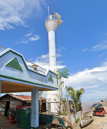
San Pablo Light, San Pablo, August 2022
Google Maps street view
Zamboanga Peninsula Region Lighthouses

Zamboanga del Sur Province Lighthouses
Zamboanga del Sur occupies the southeastern coast of the Zamboanga Peninsula facing south on the head of the Moro Gulf, a broad northern basin of the Celebes Sea.

* Tukuran (Tucuran)
Date unknown. Active; focal about 14 m (46 ft); white flash every 7 s. Approx. 12 m (39 ft) round barbell-shaped white steel and fiberglass tower. Google has a street view and the light is centered in Google's satellite view. Located at the fishing port in Tukuran, at the northern end of Pagadian Bay. Site open, tower closed. Admiralty F2225.2; NGA 15191.7.
Dao-Dao (Dumagok Island)
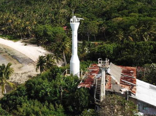
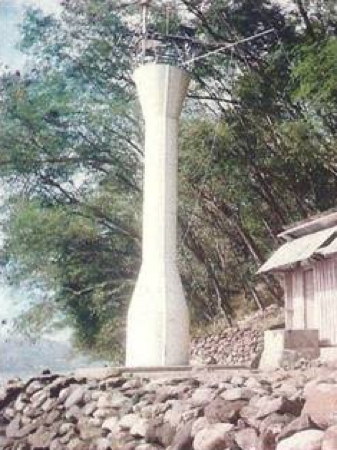
Date unknown. Active; focal plane unknown; two white flashes every 5 s. Approx. 12 m (39 ft) round barbell-shaped white steel and fiberglass tower. A photo is at right but trees obscure the light in Google's satellite view. Located on an island off the west side of Illana Bay about 2.5 km (1.5 mi) south of the waterfront of Pagadian, the provincial capital. Accessible only by boat. Site status unknown, probably open. PCG-0378; Admiralty F2224.7; NGA 15194.
San Pablo (Malubug Point)
Date unknown. Active; focal plane about 15 m (49 ft); white flash every 5 s. Approx. 12 m (39 ft) round barbell-shaped white steel and fiberglass tower. Carl Taucan has a photo and Google has the 2022 street view seen at the top of this page and a satellite view. Located at the base of the pier in San Pablo, on the west side of Illana Bay about 30 km (19 mi) south of Pagadian. Site status unknown. PCG-0772; Admiralty F2224.6.
Tabina (Tambatan Point)
Date unknown. Active; focal plane unknown; white flash every 10 s. Approx. 12 m (39 ft) round barbell-shaped white steel and fiberglass tower. Fernan Gonzales has a 2020 drone view and Google has a satellite view. Located on a sharp promontory about 8 km (5 mi) southeast of Tabina, at the southwestern entrance to Illana Bay. Site status unknown. PCG-0806; Admiralty F2224.5; NGA 15195.
Tambulian Point
Date unknown. Active; focal plane unknown; two white flashes every 10 s. No description and no photo available. Trees probably obscure the light in Google's satellite view. Located at the southern tip of the Baganian Peninsula. Site status unknown. Admiralty F2224.4.
* Margosatubig (2?)
Date unknown (station established 1910). Active; focal plane unknown; two white flashes every 5 s. Approx. 12 m (39 ft) round barbell-shaped white steel and fiberglass tower. Alvin Rex Lucero has a photo, Abu Zaeem has a 2023 photo, Google has a street view, and Bing has an indistinct satellite view. NGA describes a pierhead pole light at this port. Located at the base of the main pier at Margosatubig, a town on the east side of Dumanquillas Bay. Site open, tower closed. Admiralty F2224; NGA 15196.


Dao Dao Light, Pagadian, February 2011
ex-Panoramio photo by axlego


Zamboanga Sibugay Province Lighthouses
Zamboanga Sibugay occupies the central south coast of the Zamboanga Peninsula. Separated from Zamboanga del Sur in 2001, it surrounds Sibugay Bay, an embayment in the northwest corner of the Moro Gulf.

Malangas
Date unknown. Active; focal plane unknown; two white flashes every 10 s. Approx. 14 m (46 ft) round barbell-shaped white steel and fiberglass tower. In Crisanto Morales Garcia's distant aerial view the light is just to the left of the large cleared area on the far right. The top of the tower is seen in Google's street view and Bing has a fuzzy satellite view. Located on heights east of Malangas, a coal-shipping port and ferry terminal on the west side of Dumanguillas Bay. Site status unknown, probably open. Admiralty F2224.2; NGA 15197.
[Olutanga] (?)
Date unknown. Active; focal plane unknown; red light, pattern unknown. No description available. Olutanga is a ferry terminal on a large island in the Moro Gulf just off the mainland of the Zamboanga Peninsula. One would expect this light to be at the wharf, but a Google street view does not locate it. Google has a satellite view of the port. Admiralty F2223.
Naga
Date unknown. Active; focal plane unknown; three white flashes every 15 s. Approx. 12 m (39 ft) round barbell-shaped white steel and fiberglass tower. No photo available and the light has not been found in Google's satellite view. Located at Naga, a village at the head of Sibuguey Bay. Site status unknown, probably open. Admiralty F2222.5; NGA 15198.

Zamboanga City Lighthouses
Zamboanga is a large city at the extreme southwestern tip of Mindanao; it has an urban population of more than 2 million.

Zamboanga (2?)
Date unknown. Active; focal plane 11 m (36 ft) (?); red flash every 5 s. NGA lists a 9 m (30 ft) "beacon." Crowded with ships including numerous ferries, the Zamboanga waterfront does not have a light tower of this size. The likeliest location for the light is somewhere on an approx. 30 m (98 ft) slender skeletal tower, one of several that carries lights illuminating the wharves. A 2018 photo is available, Norwin Detalla has a street view, and Google has a street view and a satellite view. Located on the main quay at Zamboanga. Site status unknown. Admiralty F2220; NGA 15204.
Little Santa Cruz Island (2?)
Date unknown (station established 1906). Active; focal plane 16 m (52 ft); three white flashes every 15 s. 16 m (52 ft) round white barbell-shaped steel and fiberglass tower. NGA lists a "white framework structure," presumably the original lighthouse. No photo available but Google has a satellite view. Several coast guard buildings. This is the landfall light for Zamboanga for ships arriving from the west. Located on a small island about 4 km (2.5 mi) off the extreme southwestern tip of Mindanao. Accessible only by boat. Site status unknown. ARLHS PHI-037; PCG-0636; Admiralty F2218; NGA 15200.
* Batorampon Point (Labuan)
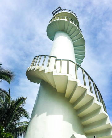
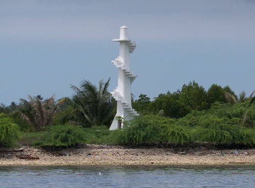
Date unknown. Active; focal plane unknown; three white flashes every 8 s. Approx. 14 m (46 ft) white concrete post; a stairway spirals around the post. Norwin Detalla has a closeup photo (also seen at right) and a street view from the top, and another photo is available, and Google has a satellite view. This light marks the westernmost point of the Zamboanga Peninsula. Located on a densely forested promontory about 30 km (19 mi) northwest of Zamboanga. Site open, and anyone can climb the stairway to the top of the tower. . Admiralty F2210; NGA 15214.


Batorampon Point Light, Zamboanga, June 2016
Google Maps photo by Norwin Detalla


Zamboanga del Norte Province Lighthouse
Zamboanga del Norte includes the northern coast of the Zamboanga Peninsula. The province has a population of about one million but much of the coastline is rugged and thinly populated.
* Sirawai
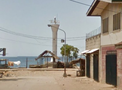
Date unknown. Active; focal plane unknown; three white flashes every 15 s. 9.5 m (31 ft) round white barbell-shaped steel and fiberglass tower. Google has a street view (a portion is seen at right) and a satellite view. Located on the quay at Sirawai, a town of about 30,000 residents about 13 km (8 mi) south of Siocon. Site open, tower closed. PCG-0369; Admiralty F2209; NGA 15214.3.
Santa Maria
Date unknown. Active; focal plane unknown; two quick white flashes every 2 s. Approx. 12 m (39 ft) round white barbell-shaped steel and fiberglass tower. No photo available and the light has not been found in Google's satellite view. Located on a promontory about 10 km (6 mi) northwest of Siocon. Site status unknown. Admiralty F2208; NGA 15214.5.
Coronado Point
Date unknown. Active; focal plane unknown; two white flashes every 10 s. Approx. 10 m (33 ft) round white concrete tower with gallery. No photo available but Google has a satellite view. Located on a forested promontory west of Gutalac and about 60 km (40 mi) northeast of Siocon. Site status unknown (this area is quite remote). Admiralty F2207.8; NGA 15214.8.
Murcielagos (Bayangan Island)
2008. Active; focal plane 11 m (36 ft); white flash every 7 s. 10 m (33 ft) round white barbell-shaped steel and fiberglass tower. Joven Embodo has a 2021 photo, the light is seen on the beach at left in a 2018 drone view by Norwin Detalla and Google has an indistinct satellite view. Located at the small settlement on Murcielagos, an island about 8 km (5 mi) northwest of La Liberdad. Accessible only by boat. Site open, tower closed. PCG-0692; Admiralty F2207.5; NGA 15214.7.

Sirawai Light, Sirawai, February 2016
Google Maps street view.
Sindangan (Liloy)
Date unknown. Active; focal plane unknown; four white flashes every 15 s. White tower, probably fiberglass. No photo available but Google has an indistinct satellite view. Located on a prominent cape about 4 km (2.5 mi) north of Liloy. Site status unknown. PCG-0367; Admiralty F2207; NGA 15215.
* Pulauan (Puluan, Dapitan Port)
Date unknown. Active; focal plane 44 m (144 ft); two white flashes every 5 s. 10 m (33 ft) concrete post with gallery and an external stairway winding around the tower. A view from the sea is available, the light is seen on the ridge right of center in Marlyn Boniao's 2018 view from the sea (light is to the right of center), and Google has a distant street view and a distant satellite view. This port is the terminal for ferries crossing the Sulu-Bohol Strait from Dumaguete, Negros. Located above the Pulauan waterfront about 13 km (8 mi) west of downtown Dapitan. Site apparently open, and the tower can probably be climbed for the view. PCG-0366; Admiralty F2284; NGA 15048.
* Tagolo (Tag-ulo) Point (3)
Late 1990s (station established 1911). Active; focal plane 33 m (109 ft); white flash every 5 s. Approx. 12 m (39 ft) round barbell-shaped white fiberglass tower. Wood keeper's cottage. A drone view is at right, Nathan Arevalo has a 2017 view from a nearby beach, Eden Recamara has a distant view, and Google has a satellite view of the station. The second (1940) light, a 7.5 m (25 ft) concrete post with an external stairway, is also standing. The City of Dapitan lists this light as a possible tourist attraction. Located on the point about 8 km (5 mi) northwest of downtown Dapitan, overlooking the Sulu Sea to the northwest and the Bohol Sea to the northeast. Site apparently open, tower closed. ARLHS PHI-098; Admiralty F2282; NGA 15052.
Selinog (Silino) Island
Date unknown. Active; focal plane about 11 m (36 ft); white flash every 5 s. Approx. 10 m (33 ft) round barbell-shaped white fiberglass tower. Jesson Astrologo has a closeup photo, a distant view is available, and Google has a satellite view. Selinog is a small island in the Bohol Sea about 30 km (19 mi) north of Dapitan. There is a resort and a nature preserve on the island. Accessible only by boat. Site open, tower closed. PCG-0776; Admiralty F2281.8; NGA 15051.8.
Piniahon (Pinihon) Island (Sibuta)
Date unknown. Active; focal plane about 15 m (49 ft); two white flashes every 10 s. Approx. 11 m (36 ft) round barbell-shaped white fiberglass tower. Antonio Soria has a 2016 photo, a 2018 photo and drone view are available, and Google has a satellite view. Located on a small island in Murcielagos Bay, an inlet of the Bohol Sea about 20 km (13 mi) east of Dapitan. Accessible only by boat. Site open, tower closed. Admiralty F2281.6; NGA 15050.
 

Old and new Tag-Ulo Lights, Dapitan, October 2020
Facebook photo posted by Dapitan City

Bangsamoro Autonomous Region: Sulu Archipelago Lighthouses

The Sulu Archipelago is a ragged chain of islands extending from the southwestern tip of Mindanao to the northeastern tip of Borneo. The largest islands are Basilan in the north, Jolo in the center of the chain, and Tawi-Tawi near the south end. The islands were governed historically as an independent sultanate. Although the islands were claimed by Spain as part of the Philippines, Spanish rule was sporadic and tenuous. In recent years, the islands were central to a Muslim separatist movement. A peace agreement in 2012 provided for the creation of an autonomous Muslim region called Bangsamoro, which includes the Sulu Archipelago and the provinces of Lanao del Sur and Maguindanao in south central Mindanao. Lighthouses in the mainland portion of the region are described on the Southern Mindanao page.

Basilan Province Lighthouses
Basilan is an island about 60 km (38 mi) long from east to west and 40 km (25 mi) wide. Under the Bangsamoro peace agreement its former capital Isabela remained part to the Zamboanga Peninsula Region while the rest of the island became part of Bangsamoro. Lamitan became the new provincial capital. Basilan is separated from Zamboanga City by the narrow (32 km, 20 mi wide) Basilan Strait.
Mataja Island
Date unknown. Active; focal plane 19 m (61 ft); white flash every 5 s. 15 m (49 ft) skeletal tower. No photo available but Google has an indistinct satellite view. This light guides ships through the Pilas Channel around the west end of Basilan. Located near the south tip of an island about 10 km (6 mi) off the western end of Basilan. Accessible only by boat. Site status unknown. Admiralty F2206; NGA 15224.
Malamaui (Malamawi) Island
1914. Reactivated; focal plane 11 m (36 ft); red flash every 5 s. 10 m (33 ft) white concrete post with an external stairway winding around the tower. Norwin Detalla has a 2018 sea view and Google has an indistinct satellite view. Mike Baylon's 2012 photo at right shows no light on the tower and Renato Apilado's photo, taken around 1990, shows that the light had been removed by that time. Located on the west side of the entrance to Isabela. Accessible only by boat. Site open, tower probably can be climbed. PCG-0413; Admiralty F2216; NGA 15220.
[Kulibato Point (Kulay Bato, Lamitan)]
Date unknown. Active; focal plane 72 m (236 ft); white flash every 5 s. 11 m (36 ft) mast painted with red and white horizontal bands. Merhan Malumin has a 2020 photo and the tip of the mast is visible above the "L" in "Lamitan" in a distant view. Google has an indistinct satellite view. Located on heights behind the port of Lamitan on the northeast coast of Basilan. Site status unknown. Admiralty F2221; NGA 15222.
Sibago Island
1915. Active; focal plane 215 m (705 ft); white flash every 10 s. 23 m (75 ft) "galvanized metal tower." Alzhaifhal Anuddin has a 2023 photo, Almadzhan Amil has a 2021 photo apparently showing part of the structure and another photo that must be taken from the top. Trees hide the tower in Google's satellite view. The 1920 light list refers to this as a "steel frame" tower. Located on a high island about 40 km (25 mi) southeast of Zamboanga, at the southwestern tip of Mindanao. Site status unknown. ARLHS PHI-057; Admiralty F2214; NGA 15216.
Malamawi Island Light
Malamawi Island Light, February 2012
Flickr photo copyright Mike Baylon; used by permission

Sulu Province Lighthouses
Sulu Province includes the central portion of the Sulu Archipelago including the major island of Jolo and surrounding smaller islands. The province has a population of about one million with about 530,000 on Jolo.
Tatalan Island
Date unknown. Active; focal plane 14 m (46 ft); white flash every 5 s. 10 m (33 ft) white concrete tower, probably with a stairway spiralling around the tower. No photo available but Google's satellite view probably shows the tip of the tower. This light marks a passage through the archipelago. Tatalan is a small forested island about halfway between Basilan and Jolo. Located on the southern tip of the island, marking a passage through the archipelago. Accessible only by boat. Site status unknown. Admiralty F2204; NGA 15228.
North Ubian Island
Date unknown. Active; focal plane 11 m (36 ft); white flash every 5 s. 10 m (33 ft) round white concrete tower mounted on a square concrete pier. No photo available but Bing has a satellite view. North Ubian Island is located about 65 km (40 mi) due west of Jolo. Located just off the northeastern tip of the island. Accessible only by boat. Site open, tower closed. Admiralty F2200; NGA 15240.
* Jolo Harbor (1)
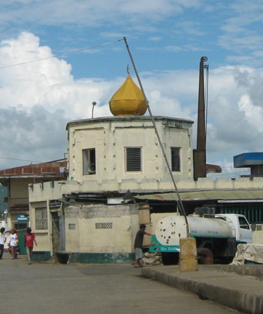
1879. Inactive since the 1930s at least. Approx. 7.5 m (25 ft) octagonal cylindrical masonry tower, now incorporated into the center of a small mosque, the Shariful Hashim Mosque. A portion of a 2009 photo is at right, a 2011 aerial photo is available, and Google has a satellite view. This is one of the oldest lighthouses in the Philippines. More recent views (no longer available online) show a ladder projecting from the top of the tower, and apparently the light was displayed for many years from the top of that ladder. Originally the tower was part of the fortifications built by Spanish forces after they captured Jolo in 1876. The mosque was apparently built around the tower in 1999 and expanded in 2010-11. Located at the base of the main wharf at Jolo. Site open, tower closed. Site manager: Masjid Shariful Hashim.
* [Jolo Harbor (3)]
2011 (station established 1879). Active; focal plane 18 m (59 ft); flashing white light. 16 m (52 ft) steel post, seen on the left in a 2023 photo. This tower replaced an earlier skeletal tower; the June 2009 photo of the mosque tower (previous entry) shows that the first skeletal tower had been removed by that time. Dr. Anak Iluh's blog post on the Jolo lighthouses states that the Coast Guard built a new lighthouse in 2011. Located on or near the base of the main wharf at Jolo. Site open. Admiralty F2196; NGA 15232.
Busbus Point (Siasi) (?)
Date unknown. Active; focal plane 9 m (30 ft); white flash every 5 s. 9 m (30 ft) white concrete quadrupod tower. No photo available but Google has an indistinct satellite view. Located on the reef on the east side of the entrance to the harbor of Siasi Island, about 80 km (50 mi) south of Jolo. Accessible only by boat. Site open, tower closed. Admiralty F2192.5; NGA 15236.5.
Jolo Light
1879 Jolo Light, Jolo, June 2009
Flickr photo copyright Pinoy Photographer; used by permission
* [Siasi Pier (2)]
Date unknown. Active; focal plane about 20 m (66 ft); continuous red light. Approx. 17 m (56 ft) steel mast. Norwin Detalla has a street view and Google has an indistinct satellite view. PCG and NGA list the mast height as 5 m (16 ft); such a short mast would be useless on the pier today. Located opposite the base of the pier at Siasi, a city of more than 80,000 residents about 80 km (50 mi) southwest of Jolo. Site open, tower closed. Admiralty F2192; NGA 15236.
Pearl Bank (2?)
Around 2018(?) (station established 1917). Active (?); focal plane 19.5 m (62 ft); white flash every 5 s. 17 m (57 ft) "red round steel tower." No photo available but Google' has a satellite view (in which the tower appears to be white). The Coast Guard listed this lighthouse as deactivated around 2012 and the Admiralty reported the light to be "temporarily extinguished" in 2008. We need information on the status of this historic light station. Located on a low island on the bank, a well-known navigational hazard about 170 km (110 mi) southwest of Jolo in the Sulu Archipelago. Site status unknown. ARLHS PHI-040; Admiralty F2194; NGA 15244.

Tawi-Tawi Province Lighthouse
Separated from Sulu Province in 1973, Tawi-Tawi Province includes the southernmost islands of the Sulu Archipelago and several isolated islands to the northeast in the Sulu Sea.
* Port Bongao
Date unknown. Active; focal plane about 12 m (39 ft); white flash every 5 s. 10 m (33 ft) white concrete tower with gallery, buttressed at the bottom, rising from a 1-story building. Raphael Navarro has a 2023 photo, Dan Noi has a 2020 photo, and Google has a satellite view. Located at the end of the pier at Bongao, the capital of Tawi-Tawi Province and the southernmost town of the Philippines. Accessible by walking the pier. Site open, tower closed. PCG-0420; Admiralty F2190; NGA 15248.
Saluag Island (1)
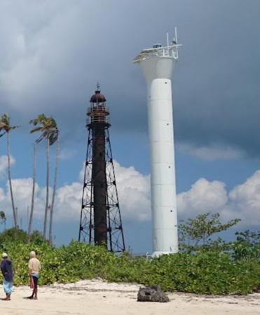
Date unknown. Inactive. 26 m (85 ft) square skeletal tower with lantern and central cylinder. A photo by Voughx Pajiji is at right, he has a closeup photo of both lighthouses, Jan Vincent Francisco also has a photo, Robin Directo has a 2022 photo, and Google has a satellite view of the station. The lighthouse must be from the early years of the American administration. It was active in the 1970s and probably for many years after that. Probably endangered now. Located on an islet off the south end of Sibutu Island. Accessible only by boat. Site status unknown. ex-Admiralty F2186.
Saluag Island (2)
Date unknown. Active; focal plane 29 m (95 ft); white flash every 5 s. Approx. 15 m (49 ft) round cylindrical steel or concrete tower, painted white. A photo by Voughx Pajiji is at right., Robin Directo has a 2022 photo, This is the southernmost lighthouse of the Philippines. Located adjacent to the historic lighthouse. Accessible only by boat. Site status unknown. ARLHS PHI-114; Admiralty F2189; NGA 15246.
Tandotao Point (Cagayan Sulu, Mapun)
Date unknown. Active; focal plane 118 m (387 ft); white flash every 5 s. 10 m (33 ft) white concrete post with an external ladder. A distant 2020 view from the sea is available (lighthouse on the summit on the right) and Google has a satellite view. Mapun (formerly called Cagayan de Sulu) is an isolated island in the southwestern Sulu Sea. Although it is remote from the Sulu Archipelago it is governed as a municipality within Tawi-Tawi Province. The population is about 30,000. Located on heights at the southeastern tip of the island. Site status unknown. PCG-0347; Admiralty F2142; NGA 14544.

Information available on lost lighthouses:

Notable faux lighthouses:

  •  

Old and new Salaug Island Lights, Tawi-Tawi, March 2016
Google Maps photo by Voughx Pajiji

Adjoining pages: Northeast: Northern Mindanao | East: Southern Mindanao | Southwest: Malaysia: Labuan and Sabah | West: Palawan

Return to the Lighthouse Directory index | Ratings key

Posted July 24, 2005. Checked and revised February 13, 2024. Lighthouses: 33. Site copyright 2024 Russ Rowlett and the University of North Carolina at Chapel Hill.