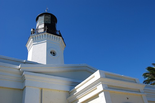
Lighthouses of Puerto Rico

Puerto Rico, the easternmost island of the Greater Antilles, was a Spanish colony until it was captured by U.S. forces during the Spanish-American War of 1898. It is now a self-governing commonwealth within the United States. The island is roughly 110 mi (180 km) long and 40 mi (65 km) wide.

Puerto Rico's 16 surviving light stations include 11 historic lighthouses built by the Spanish before the U.S. annexation. Some of these Spanish lighthouses are revered national monuments, but several others are abandoned and endangered. Fortunately, interest in lighthouse preservation has increased greatly in recent years, and major restoration projects have been carried out at Arecibo, Cabo Rojo, and Punta de las Figuras. But much remains to be done, and five Puerto Rican lighthouses remain on the Lighthouse Digest Doomsday List.

The Spanish word for a lighthouse is faro. Aids to navigation in Puerto Rico are maintained by the U.S. Coast Guard.

ARLHS numbers are from the ARLHS World List of Lights. Admiralty numbers are from volume J of the Admiralty List of Lights & Fog Signals. USCG numbers are from Volume III of the U.S. Coast Guard Light List. U.S. NGA List numbers are from Publication 110.

General Sources
Faros de Puerto Rico
Excellent photos and information on the history and status of the lighthouses, by José A. Mari-Mutt. The entire site is presented in both English and Spanish.
Puerto Rico Lighthouses
Photos and historical accounts posted by Kraig Anderson.
Faros de Puerto Pico
An excellent Spanish-language site by Alexis Colón-Sepúlveda, featuring photos and historical information on the historic Spanish lighthouses.
Puerto Rico Lighthouses
A Flickr.com set of photos, taken in 2010 by Larry Myhre.
Online List of Lights - Puerto Rico
Photos by various photographers posted by Alexander Trabas.
Lighthouses in Puerto Rico
Photos available from Wikimedia.
Coast Guard Lighthouses - Puerto Rico
Data and historic photos posted by the U.S. Coast Guard Historian's office.
The Doomsday Lighthouses of Puerto Rico
Lighthouse Digest article of February 2002 by Bob and Sandra Shanklin.
Lighthouses in the Caribbean
Excellent aerial photos posted by Marinas.com.
Leuchttürme Mittelamerikas und der Karibik auf historischen Postkarten
Historic postcard views posted by Klaus Huelse.

San Juan Light, San Juan, February 2004
Flickr Creative Commons photo
by Tomás Fano
Mona Island Lighthouse
Isla de Mona
1900. Inactive since 1976. 52 ft (16 m) pyramidal skeletal cast iron tower with central cylinder, lantern and gallery. Originally painted black, the lighthouse is now covered with rust. The active light (1976; focal plane 323 ft (98 m); white flash every 5 s) is on a 40 ft (12 m) steel tower. The original 2nd order Fresnel lens, the largest lens ever used in Puerto Rico, is in storage for eventual display at a proposed reseach and visitor center on the island. Anderson has a fine page with several photos, Colón-Sepúlveda has a recent photo, Marinas.com has aerial photos, Huelse has a historic postcard view, and Google has a satellite view. The Coast Guard has a photo of the light station in service, and Wikimedia has a 1977 photo from the Library of Congress. The lighthouse has deteriorated severely since deactivation and is in danger of being lost, according to an October 2004 article by Sandra Shanklin. The abandoned lighthouse has been added to the Lighthouse Digest Doomsday List. Mari-Mutt has a 2008 photo by Juan García and writes that the tower is "beyond repair." The Isla de Mona, part of the Commonwealth of Puerto Rico, is located in the Mona Passage between the Puerto Rican mainland and the Dominican Republic. Uninhabited except when visited by biological and ecological researchers, it is accessible by charter and tour boats (6 hour trip one way) from Mayaguez and Cabo Rojo. Located on a high bluff on the east side of the island, accessible by hiking trails from established campsites. Site open, tower closed. Owner: U.S. Coast Guard. Site manager: Departamento de Recursos Naturales. ARLHS PUR-011; Admiralty J5486; USCG 3-32295; NGA 14412.

Northern Puerto Rico Lighthouses
** Punta Higuero (Point Jiguero, Rincón) (2)
1922 (station established 1892). Active; focal plane 90 ft (27 m); white light occulting every 4 s. 69 ft (21 m) round cylindrical reinforced concrete tower with lantern and gallery; 250 mm lens. Tower painted white; the gallery and lantern roof are black. José Oquendo's photo appears at right, Anderson has a fine page with several photos, Mickey Carrasquillo also has a good photo, Marinas.com has aerial photos, the Coast Guard has a historic photo, and Google has a good satellite view. The original lighthouse was destroyed by the earthquake and tsunami of 11 October 1918; Huelse has a historic postcard view. The original lantern was installed on the new tower and remains in use today. The lighthouse is the centerpiece of El Faro Park, a popular surfing and whale watching site. The park includes a visitor center and gift shop. Located off highway 413 north of Rincón at the westernmost point of the island, marking the entrance from the Atlantic to the Mona Passage. Site open, tower closed. Owner: U.S. Coast Guard. Site manager: Municipio de Rincón. ARLHS PUR-019; Admiralty J5488; USCG 3-32400; NGA 14416.
* [Punta Borinquen (Aguadilla) (1)]
1889. Inactive since 1918, when the lighthouse was nearly destroyed by a tsunami. The lighthouse was an octagonal cylindrical stone tower with lantern and gallery, rising from a 1-story stone keeper's house, similar to the Cabo San Juan lighthouse. Foundations and portions of the walls are standing. Josh Bozarth has a good photo, a 2008 photo is available, and Google has Angel Reyes's street view and a satellite view. This lighthouse was very similar to the surviving Maunabo lighthouse (see below). Located at the northwestern tip of the island, about 2 km (1.25 mi) from the present lighthouse. Site open. Owner/site manager: U.S. Coast Guard. ARLHS PUR-022.
* Punta Borinquen (Aguadilla) (2)
1920. Active; focal plane 292 ft (89 m); two white flashes, separated by 4 s, every 15s. 60 ft (18 m) round cylindrical stone tower with gallery, unpainted; DCB-224 aerobeacon. The lantern was removed in 1947. The 1-story keeper's house is used as vacation housing for Coast Guard personnel. Anderson has an excellent page for the station, Marinas.com has aerial photos, the Coast Guard has a historic photo and second photo showing the original lantern, and Google has a satellite view. The lighthouse is adjacent to a popular golf course built on the former Ramey Air Force Base, now the Rafael Hernández Airport. Borinquen is the original Indian name of Puerto Rico. Located north of Aguadilla near the northwesternmost point of the island; Site and tower closed. Owner/site manager: U.S. Coast Guard. ARLHS PUR-013; Admiralty J5490; USCG 3-30715; NGA 14420.
Faro de Rincón
Punta Higuero Light, Rincón, September 2007
Wikimedia Creative Commons photo
by José Oquendo
*** Arecibo (Punta Morrillo)
1898. Active; focal plane 120 ft (36 m); white flash every 5 s. 46 ft (14 m) hexagonal cylindrical stone tower attached to 1-story stone office and keeper's house; 190 mm lens. Tower painted white. The original lantern, remove many years ago, has been replaced by a restored lantern with an unpainted copper roof. Myhre's 2010 photo is at right, Mari-Mutt has a good page for the lighthouse, Anderson also has a fine page with several photos, Marinas.com has aerial photos, the Coast Guard has a historic photo, Huelse has a historic postcard view, and Google has a distant street view and a good satellite view. This is the last lighthouse built by the Spanish in Puerto Rico; American forces placed it in service several months after conquering the island. The city replaced the lantern and restored the lighthouse in 2001-02 and has opened the building as a historical museum. Located northeast of Arecibo, on the east side of the harbor entrance. Site open (park entry fee), lighthouse open daily, tower status unknown. Owner: U.S. Coast Guard. Site manager: Municipio de Arecibo (Arecibo Lighthouse and Historical Park ). ARLHS PUR-001; Admiralty J5492; USCG 3- 30720; NGA 14432.
* Puerto San Juan (El Morro) (3)
1908 (station estalished 1846). Active; focal plane 181 ft (55 m); white flashes every 10 s, every fourth flash omitted. 51 ft (15.5 m) square brick Moorish tower atop the battlements of El Morro (San Felipe del Morro), the castle-like fort guarding the entrance to San Juan harbor. Light tower painted gray, gallery and trim white, lantern black. A 3rd order Fresnel lens installed in 1899 remains in use. Tomás Fano's photo is at the top of this page, Anderson has an excellent page for the lighthouse, Trabas has a closeup by Douglas Cameron, Marinas.com has fine aerial photos, and Bing has a satellite view. There was never a keeper's house at this station; keepers lived in the city of San Juan. This lighthouse, with its unique and beautiful design, represents Puerto Rico's oldest light station. Mari-Mutt has photos of the 1846 and 1899 towers; the former was demolished after being heavily damaged by U.S. bombardment in 1898. The lighthouse was restored by the National Park Service in 1991. Located on the east side of the entrance to San Juan harbor. Site open (1/4 mile (400 m) walk from parking), tower closed. Owner: U.S. National Park Service. Site manager: San Juan National Historic Site. ARLHS PUR-005; Admiralty J5494; USCG 3-30735; NGA 14436.
** Cabo San Juan (Fajardo)
1880. Active; focal plane 260 ft (79 m); white flash every 15 s. 45 ft (14 m) cylindrical stone tower; DCB-24 aerobeacon. Tower painted light gray with white trim, lantern black. The original 1-story neoclassical stone keeper's house is used as a nature center and marine laboratory operated by the Universidad de Puerto Rico en Humacao. Larry Myhre's photo is at right, a closeup of the tower is available, Marinas.com has aerial photos, the Coast Guard has a historic photo, Huelse has a historic postcard view, and Google has a good satellite view. This beautiful and well-preserved Spanish lighthouse is the oldest surviving lighthouse in Puerto Rico. It was repaired after being heavily damaged by the San Ciprián hurricane in September 1932. The Puerto Rico Conservation Trust purchased the surrounding land in 1975 and restored the lighthouse in 1990. Located in the Cabezas de San Juan Nature Reserve on the northeasternmost point of the island, northeast of Fajardo, commanding a spectacular view. Site and tower open to guided tours Friday through Sunday (reservations required). Owner: U.S. Coast Guard. Site manager: Puerto Rico Conservation Trust (Fideicomiso de Conservación de Puerto Rico). ARLHS PUR-021; Admiralty J5528; USCG 3-31155; NGA 14464.

Arecibo Light
Arecibo Light, Arecibo, February 2010
Flickr Creative Commons photo by Larry Myhre

Faro de Fajardo
Cabo San Juan Light, Fajardo, February 2010
Flickr Creative Commons photo by Larry Myhre


Culebra and Vieques Lighthouses
Note: Vieques and Culebra are islands located off the east coast of Puerto Rico. Vieques is about 34 km (21 mi) long and has a population of about 10,000. Culebra is about 8 km (5 mi) in diameter has has a population of less than 2,000. Both islands are accessible by air and by ferries from Fajardo and San Juan.
Culebrita
1886. Reactivated (inactive 1959-1975); focal plane 305 ft (93 m); white flash every 10 s. 43 ft (13 m) cylindrical stone tower rising from the center of a 1-story stone keeper's house. Although a July 2006 photo shows the small modern light in the shattered lantern, it is amazing that this lighthouse is in service. As of late 2000, the building was in ruins, severely damaged by vandals and by Hurricanes Hugo (1989) and Marilyn (1995). Anderson has a good page for the light station, Marinas.com has aerial photos, Huelse has a historic postcard view, Colón-Sepúlveda has an 1895 historic photo, and Google has a satellite view. This is another lighthouse on the Lighthouse Digest Doomsday List. The building is reported to be hazardous inside. In 2003 ownership of the light station was transferred from the Culebra National Wildlife Refuge to the Municipality of Culebra. A commonwealth grant of $700,000 was reported to be available for preliminary restoration, and architects had been hired to supervise the work. However, Mari-Mutt reports that the restoration project failed to take place. Yubal Oliveras's June 2007 photo and an April 2008 photo show no evidence of work in progress. In January 2015, the environmental organization Para la Naturaleza signed an agreement with the municipality of Culebra to restore the lighthouse, beginning with stabilzation of the surviving structure. Located on the highest point of Culebrita, off the eastern tip of Culebra and overlooking the Virgin Passage. Accessible only by boat (good anchorage available; day tours available from Culebra, which can be reached by air from San Juan or by ferry from Fajardo). However, it's a long, hot hike from the beach to the lighthouse. Site open; tower open. Owner/site manager: Municipio de Culebra. ARLHS PUR-004; Admiralty J5608; USCG 3-31685; NGA 14480.
* Punta Mulas (Morropó, Isabella Segunda)
1896. Reactivated; focal plane 68 ft (21 m); red light occulting every 4 s. 32 ft (10 m) octagonal cylindrical brick tower rising from 1-story brick keeper's house; original 6th order Fresnel lens. Lighthouse painted cream with white trim, lantern black. John Y. Lee's photo is at right, Anderson has a good page for the lighthouse, Colón-Sepúlveda has good photos, and the Coast Guard has a historic photo, Huelse has a historic postcard view, and Google has a satellite view. Restored in 1992, the building formerly housed a small museum. However, Mari-Mutt reports that the building has deteriorated and is now closed to the public. Located on the east side of the entrance to the harbor of Isabella Segunda (Vieques) on the north side of the island of Vieques. Site open, tower closed. Owner: U.S. Coast Guard. Site manager: Municipio de Vieques. ARLHS PUR-015; Admiralty J5592; USCG 3-31530; NGA 14497.
* Puerto Ferro
1896. Inactive since 1926. Octagonal cylindrical stone tower rising from the center of 1-story stone keeper's house. The active light (focal plane 56 ft (17 m); white flash every 4 s; USCG 1- 31715) is on a skeletal tower next to the lighthouse. Lantern removed. Anderson has a good page for the lighthouse, Colón-Sepúlveda has a portfolio of historic photos, the Coast Guard has a historic photo, and Google has a satellite view. Endangered by decay and lack of maintenance, the lighthouse has fallen into ruin and has been added to the Lighthouse Digest Doomsday List. The lighthouse is in the former U.S. military base area; the Navy withdrew from these bases, after years of public protests, in May 2003. Located on the central south coast of Vieques inside the former Camp Garcia Marine Base. Accessible by a hike of about one hour round trip (Mari-Mutt recommends visiting early in the day). Site open weekdays, tower closed. Owner: U.S. Coast Guard. Site manager: U.S. Marine Corps. ARLHS PUR-024.

Punta Mulas Light, Isabella Segunda, Vieques, December 2004
Flickr Creative Commons photo
by John Y. Lee

Southern Puerto Rico Lighthouses
*** Punta Tuna (Maunabo)
1892. Active; focal plane 111 ft (34 m); two white flashes, separated by 10 s, every 30 s. 49 (15 m) ft octagonal cylindrical brick tower rising from a 1-story brick keeper's house; 190 mm lens. Lighthouse painted white, lantern black; the keeper's house is painted cream with white trim. The original 3rd order Fresnel lens, somewhat damaged by vandals, remains in the tower but is not in use. Jorge Rodriguez's photo is at right, Anderson has a fine page for the station, Marinas.com has aerial photos, Huelse has a historic postcard view, and Google has a satellite view. In 2006, George Van Parys founded a support organization called Faro de Punta Tuna or Punta Tuna Lighthouse to work toward ownership and restoration of the lighthouse. In 2009 the lighthouse became available for transfer under NHLPA, and in October 2012 it was announced that it will be transferred to the City of Maunabo. Located southeast of Maunabo on a sharp promontory at the southeasternmost point of the island. Site open, lighthouse and tower open daily Wednesday through Sunday. Owner: U.S. Coast Guard. Site manager: City of Maunabo. ARLHS PUR-016; Admiralty J5545; USCG 3-31800; NGA 14512.
* Punta de las Figuras (Point Figuras, Arroyo)
1893. Inactive since 1938. Approx. 50 ft (15 m) octagonal cylindrical brick tower attached to 1-story brick keeper's house. Lighthouse painted cream with white trim. Larry Myhre's photo is at right, Hector Vincent Alvarez has a closeup photo, and Marinas.com has aerial photos. The original lantern and lens were destroyed by vandals in 1969. By early 2001, the lighthouse was in very poor shape, with no roof and only scraps of its lantern; this earned it a spot on the Lighthouse Digest Doomsday List. However, the Compañía de Parques Nacionales beautifully restored the lighthouse in 2002-03. The restoration cost $2.3 million and is part of a larger project creating a public recreation facility in the area. Google's satellite view shows the swimming pool and other facilities located adjacent to the light station. On the beach nearby is the metal ruin of a former range light, also long abandoned. Located southeast of Arroyo on the southeastern coast of the island. Owner/site manager: Puerto Rico Compañía de Parques Nacionales (Parque Nacional Punta Guilarte). ARLHS PUR-014; ex-Admiralty J5489.
Isla Caja de Muertos (Coffin Island, Muertos Island)
1887. Active; focal plane 297 ft (91 m); white flash every 30 s. 63 ft (19 m) cylindrical stone tower attached to 1-story stone keeper's house; 500 mm lens. Lighthouse painted white, lantern black. Anderson has a good page with several photos, Marinas.com has aerial photos, Colón-Sepúlveda has an 1895 historic photo, the Coast Guard also has a historic photo, and Google has a satellite view. Poorly maintained, the light station is on the Lighthouse Digest Doomsday List. The Shanklins found the keeper's house unsecured and open to the elements, and Mari-Mutt writes that holes in the roof are allowing rain to drench the interior. Caja de Muertos is a small island in the Caribbean about 8 km (5 mi) southeast of Ponce; it is accessible by passenger ferry from Ponce on weekends. The island is a nature preserve. Lighthouse located on the highest point of the island, more or less accessible by a very steep and difficult hiking trail. Site open, tower apparently open but dangerous. Owner: U.S. Coast Guard. Site manager: Departamento de Recursos Naturales. ARLHS PUR-003; Admiralty J5556; USCG 3-31925; NGA 14524.
Isla de Cardona (Ponce, Cayo Cardona)
1889. Active; focal plane 46 ft (14 m); white flash every 4 s. 36 ft (11 m) cylindrical stone tower attached to 1-story stone keeper's house. Lighthouse painted white; lantern is black. The original 6th order Sautier, Lemonier & Cie. Fresnel lens is on display in the Coast Guard Museum in San Juan. Anderson has a good page with recent and historic photos, Marinas.com has aerial photos, Colón-Sepúlveda has a historic photo and an aerial photo of the island and lighthouse, the Coast Guard also has a historic photo, and Google has a satellite view. Mari-Mutt writes that salt spray has severely corroded the lantern and the lighthouse is probably in need of a complete restoration. Located on the highest point of a small island about 2 km (1.2 mi) southeast of Ponce, marking the entrance to Ponce harbor. Site and tower closed. Owner/site manager: U.S. Coast Guard. ARLHS PUR-009; Admiralty J5560; USCG 3-31950; NGA 14536.

Faro de Punta Tuna
Punta Tuna Light, Maunabo, January 2008
Flickr Creative Commons photo by Jorge Rodriguez

Faro de Arroyo
Punta de las Figuras Light, Arroyo, February 2010
Flickr Creative Commons photo by Larry Myhre

* Guánica (Cana)
1893. Inactive since 1950. Octagonal cylindrical masonry tower attached to a 1-story masonry keeper's house; lantern removed. The tower and and keeper's house are in ruins. The lighthouse was replaced by a buoy offshore. Anderson has an excellent page based on a recent visit, Colón-Sepúlveda has a historic photo and a portfolio of photos of the current ruins, a 2008 photo is available, the Coast Guard has a historic photo of the intact lighthouse, and Bing has a satellite view. This is a critically endangered lighthouse; the building appears to be in danger of collapse. Lighthouse Digest Doomsday List. Mari-Mutt writes that "in May 2007, the Guánica municipality and the Department of Natural Resources signed an agreement to restore the lighthouse and its surroundings," but no work had begun by the time of Larry Myhre's February 2010 photo. In November 2012 the newspaper El Nuevo Día reported that work was set to begin in 2013. So far, no evidence of this work has been seen. The lighthouse is within a commonwealth nature reserve, Bosque Seco de Guánica (Guánica Dry Forest). Located on PR 333 about 2.5 km (1.5 mi) south of Guánica, where the lighthouse formerly marked the east side of the entrance to the Bahía de Guánica. Site open, tower closed. Owner/site manager: Departamento de Recursos Naturales. ARLHS PUR-007.
**** Cabo Rojo (Los Morrillos)
1882. Active; focal plane 121 ft (37 m); white flash every 20 s. 40 ft (12 m) hexagonal cylindrical stone tower attached to a 1-story stone keeper's house; DCB-24 aerobeacon. Lighthouse painted gray with white trim. Don Gabo's photo is at right, Anderson has a good page with several photos. Phil Putnam has also posted a good photo, Marinas.com has aerial photos, Huelse has a historic postcard view, and Google has a satellite view. The lighthouse was renovated in 1986, but therafter it was not maintained and rapidly deteriorated through neglect and vandalism. In early 2001 the lighthouse was in very poor condition. In June 2002 the city government announced it would spend $4.5 million to restore the lighthouse, construct a visitor center, and establish a nature preserve in the surrounding area. Restoration of the light station began later in 2002 and was completed in October 2004. A second phase of the project developed the grounds with walkways and wildlife viewing platforms. The lighthouse reopened to the public in 2007; the city has a web page. Interior renovations were completed in 2013-14. The light station is located within the Cabo Rojo National Wildlife Refuge. Located on a dramatic limestone bluff overlooking the Caribbean at the end of PR 301 at Cabo Rojo, the southwestern tip of the island. Site open, lighthouse and tower open daily Wednesday through Sunday. Owner: U.S. Coast Guard. Site manager: Municipio de Cabo Rojo. ARLHS PUR-002; Admiralty J5578; USCG 3-32290; NGA 14572.

Information available on lost lighthouses:

  • Isla Cabras (Ceiba) (1908-1966), east end of Puerto Rico. This lighthouse was similar in design to the San Juan lighthouse. It was deactivated in 1937 and demolished in 1966--a great loss. The Vieques Southwest Channel Range Front Light (Admiralty J5536; NGA 14511) was near the site on a skeletal tower, but this light has also been discontinued. ARLHS PUR-008.

Cabo Rojo Light, Cabo Rojo, May 2007
Flickr Creative Commons photo
by Don Gabo

Adjoining pages: East: U.S. Virgin Islands | West: Dominican Republic

Return to the Lighthouse Directory index

Posted December 1999. Checked and revised November 6, 2014. Lighthouses: 16. Site copyright 2014 Russ Rowlett and the University of North Carolina at Chapel Hill.